Three fires spreading rapidly northeast of Flagstaff, AZ

Haywire Fire, Pipeline Fire, and Double Fire

Updated at 7:06 a.m. MDT June 14, 2022

map Pipeline & Haywire Fires 930 p.m. MDT June 13, 2022
Map showing the perimeters of the Pipeline & Haywire Fires at 9:30 p.m. MDT June 13, 2022. The red dots represent heat detected by a satellite at 1:41 a.m. MDT June 14, 2022.

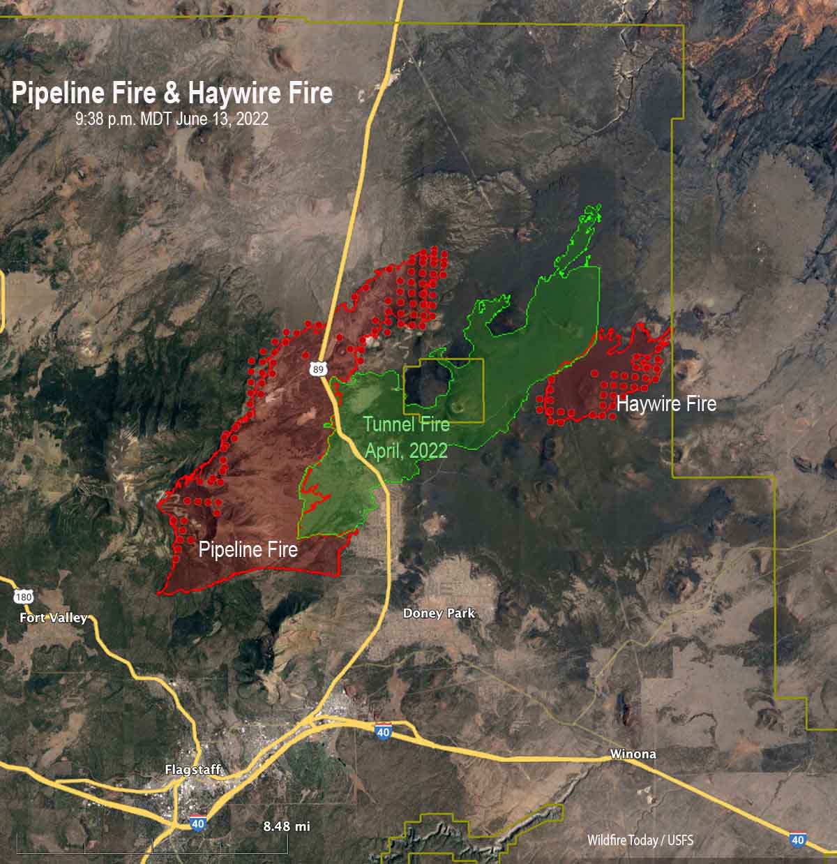
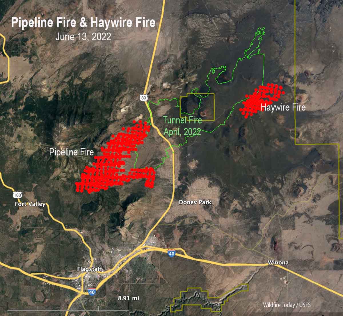
A mapping flight at 9:38 MDT Monday night determined that the Pipeline Fire had grown to 20,178 acres and the Haywire Fire was 4,051 acres. Both blazes are within the Coconino National Forest, but at that time the Haywire Fire had reached the boundary and may spread outside the Forest. The Double Fire appears to have merged with the Haywire Fire.

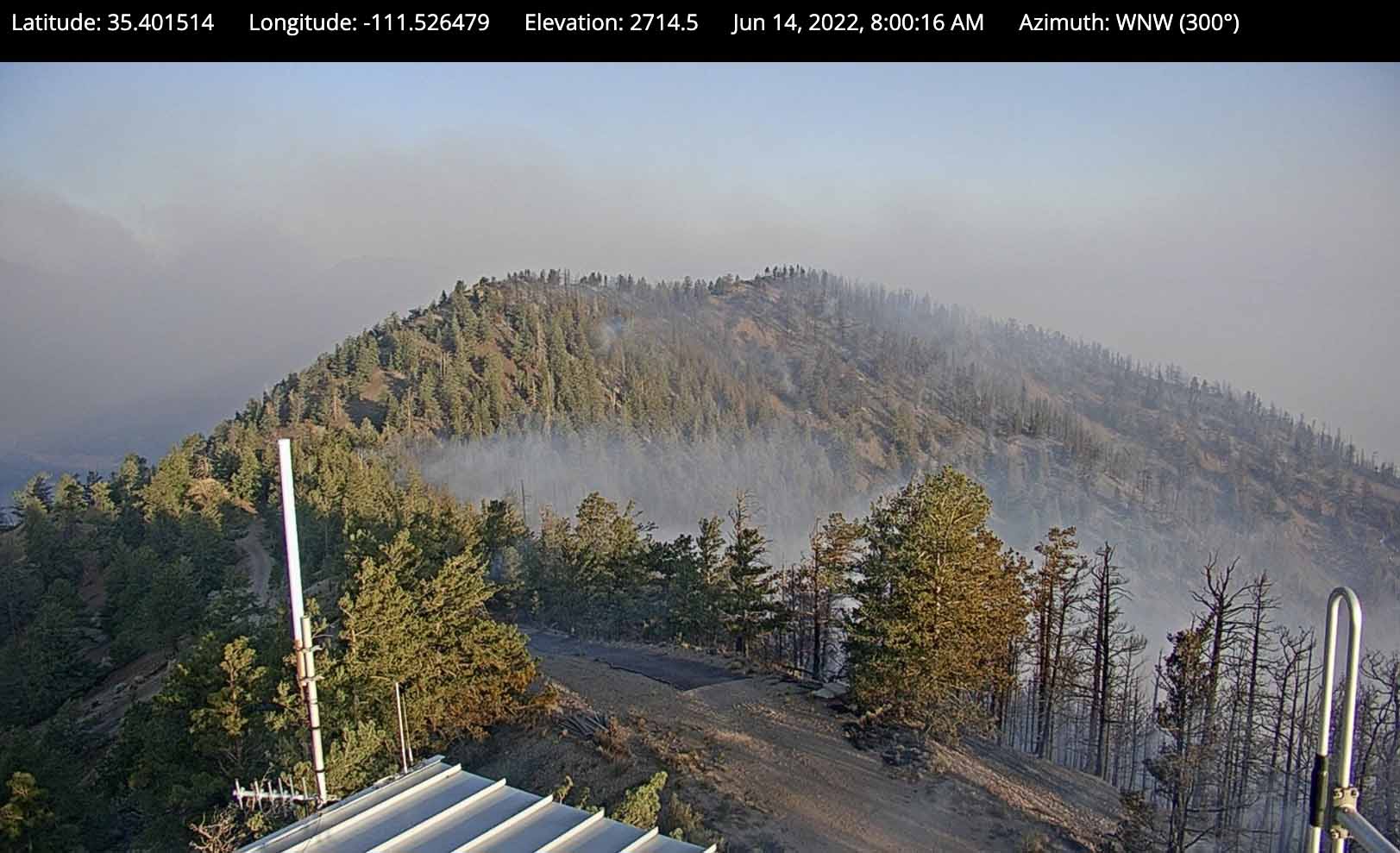
The fires are burning in timber and grass. Some of the areas near the Sunset Crater Volcano National Monument have volcanic soils with little vegetation between patches of shrubs, grass, and trees. The elevation ranges from 6,000 to 10,000 feet, with the higher elevations on the west side of the Pipeline fire having a much greater density of timber as evidenced by the photo below and the extreme fire behavior Monday when flames at least 400 feet high were seen in videos.

Pipeline & Haywire Fires June 14, 2022
View from the OLeary camera, north of the National Monument at 8 am. June 14, 2022.

In April of this year the 19,000-acre Tunnel Fire burned across the National Monument. The photo below was taken in 2017.

Sunset Crater Volcano National Monument
Sunset Crater Volcano National Monument, May 20, 2017.

Updated at 11:00 p.m. MDT June 13, 2022

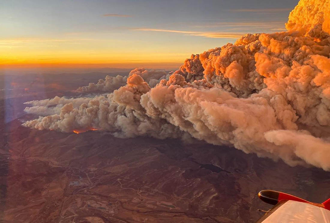
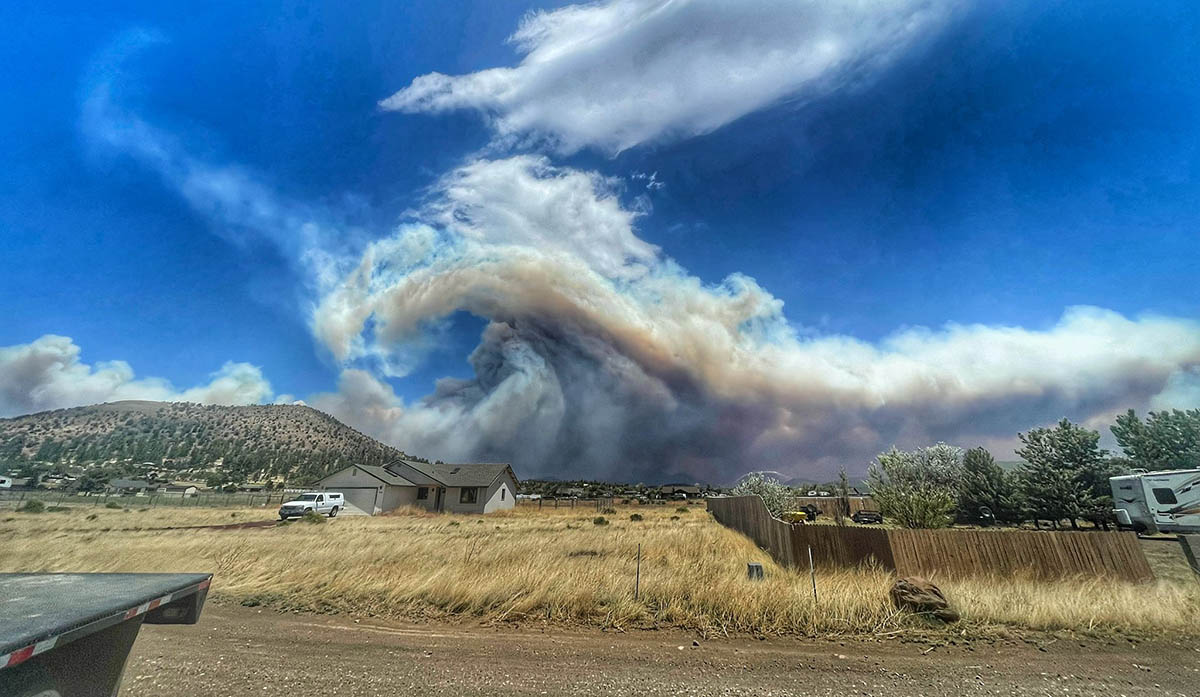
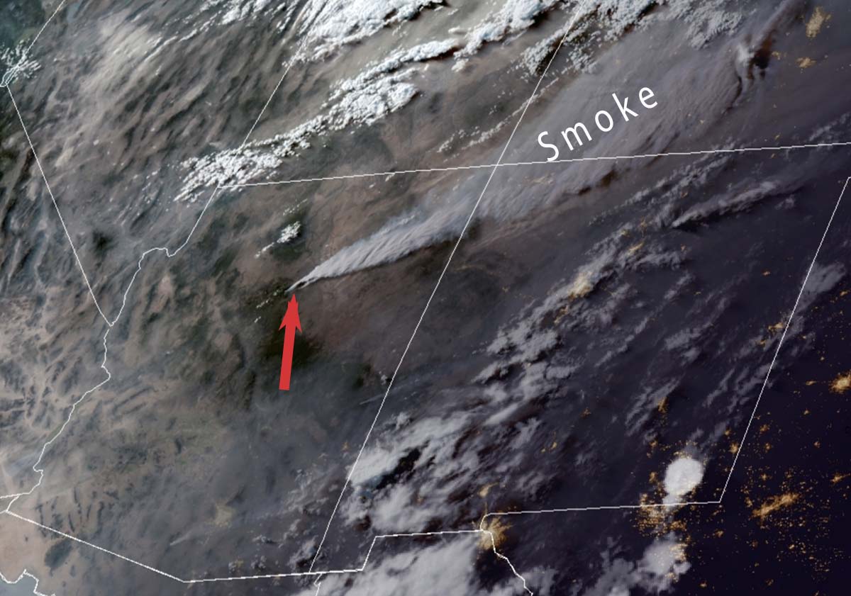
I have seen and been under many smoke columns, but I’ve never seen this on a large fire. Things that come to mind are mountain wave and wind shear. And, GTFO.

Here’s another photo.

Pipeline Fire north of Flagstaff June 13, 2022, by @russdussel

Fire officials said the Pipeline Fire has burned about 6,500 acres.

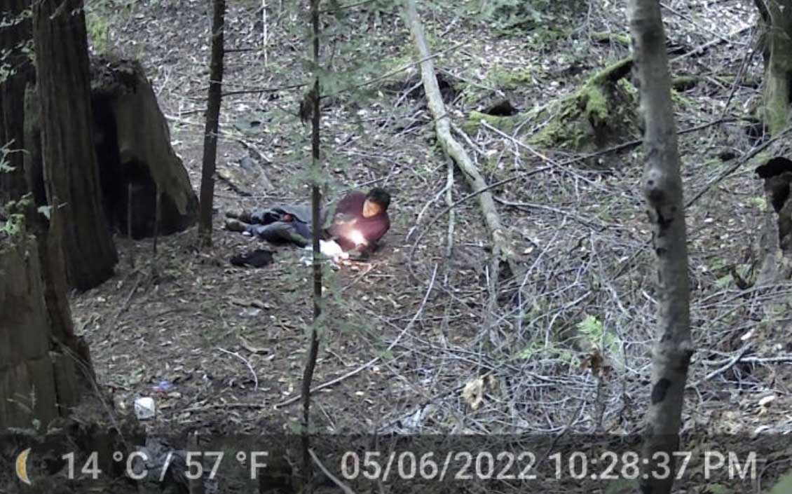
A man has been arrested Sunday in connection with starting the fire. He told officers he had ignited toilet paper after using it and placed it under a rock Saturday, and that he tried to put out the fire with his sleeping bag. His camp was 80 yards from where the fire started, according to court documents.

This is not the first time a wildfire has been ignited by burning toilet paper. We have eight other articles on Wildfire Today tagged “toilet paper”.

Thanks and a tip of the hat go out to Dick.


Updated at 8:13 p.m. MDT June 13, 2022

Map of the Pipeline & Haywire Fires
Map of the Pipeline & Haywire Fires. Data accessed at 7 p.m. MDT June 13, 2022. The exact time the data was created on June 13 is unknown.

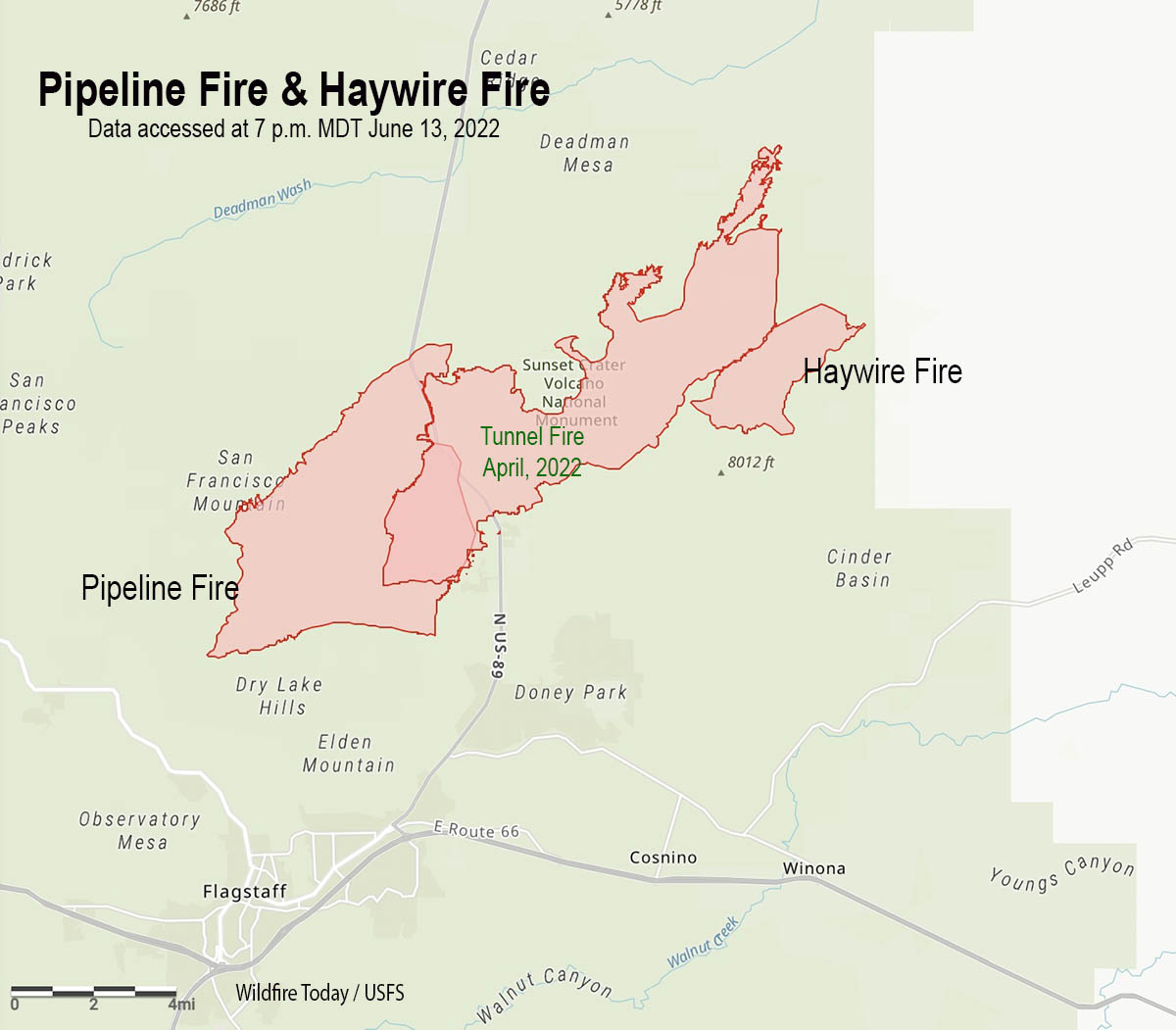
In a briefing Monday evening fire officials said at least one structure has been destroyed in the three fires burning north and northeast of Flagstaff, Arizona. It appears that the Pipeline, Haywire, and Double Fires have or will soon merge with the footprint from the Tunnel Fire that burned about 19,000 acres north of Flagstaff in April of this year.

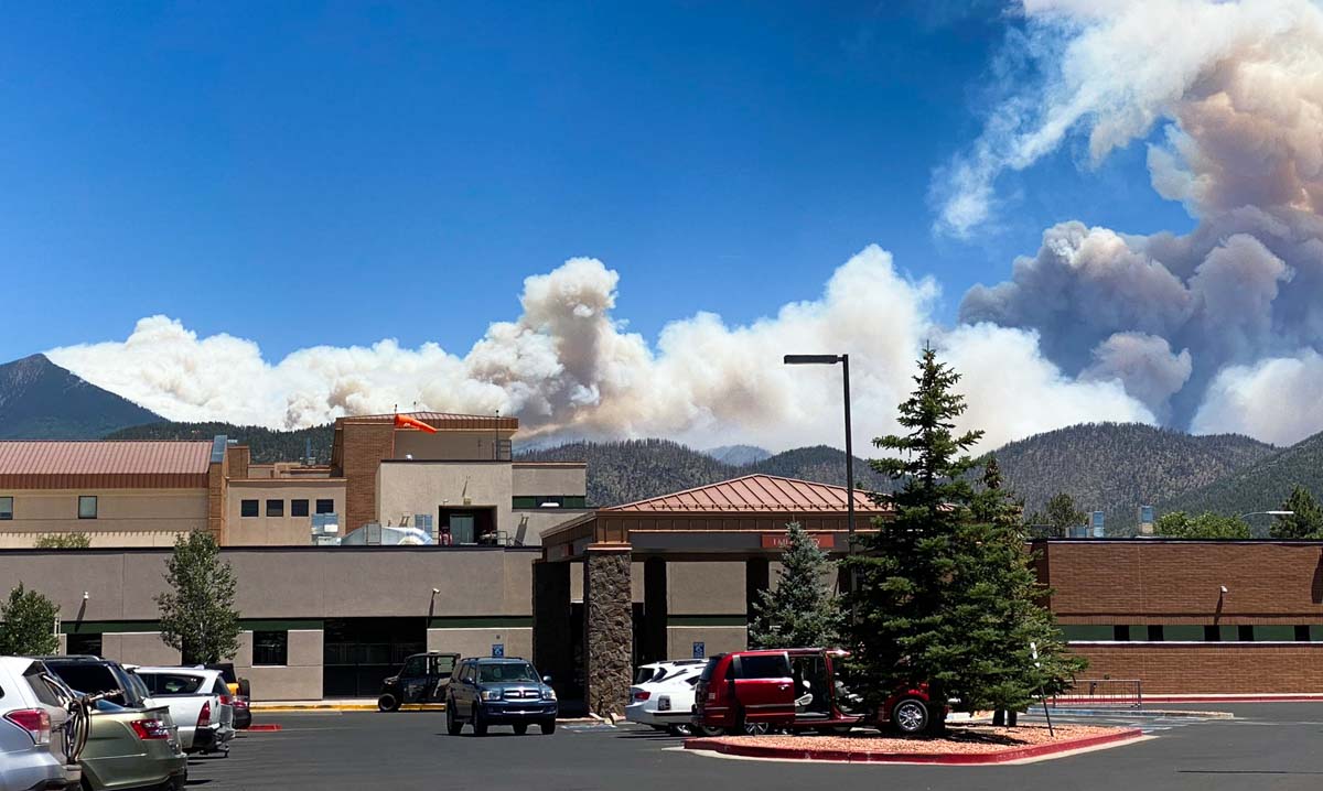
The blaze was exhibiting extreme fire behavior Monday afternoon.

Coconino County has established a website with maps showing evacuation status.

Satellite photo smoke Pipeline and Haywire Fires
Satellite photo showing smoke from the Pipeline and Haywire Fires at 6:21 p.m. MDT June 13, 2022. The red arrow points to the fires. NOAA.

Monday afternoon the wind near the fire was gusting as high as 49 mph out of the south-southwest while the relative humidity dropped as low as 6 percent. This, and the very dry vegetation, accounts for the extreme fire behavior on Monday.


2:35 p.m. MDT June 13, 2022

map Pipeline Fire, June 13, 2022 Arizona Flagstaff
Map of the Pipeline Fire ane Haywire Fire, June 13, 2022. The Tunnel Fire, the green perimeter, burned in April, 2022. The red dots represent heat detected by a satellite at 2:49 a.m. MDT June 13, 2022.

Three fires in northern Arizona are spreading rapidly in the Coconino National Forest north and northeast of Flagstaff.

The Pipeline Fire six miles north of the city started Sunday morning June 12. On Monday it has been pushed by winds gusting out of the southwest at 25 to 35 mph as the relative humidity dropped to 10 percent in the afternoon. It has reached the Tunnel Fire that blackened about 19,000 acres in April of this year. Judging from the massive smoke column it appears to be burning around it. Fire officials estimate it has blackened approximately 5,000 acres, but that number is changing hourly.

Pipeline Fire, June 13, 2022 Arizona Flagstaff
Pipeline Fire, June 13, 2022, by @RealTaoOfSwan.

Another fire, the Haywire Fire, was was reported Sunday afternoon on the southeast side of the Tunnel Fire perimeter. It is about seven miles northeast of the Pipeline Fire, making it unlikely that it could have begun as a spot fire started by a lofted burning ember. Fire authorities said the probable cause of the 1,600- acre fire is from a lightning strike several days earlier and is expected to merge with the Double Fire.

A third fire was also reported Sunday afternoon about two miles south of the Haywire Fire. The Double Fire has burned about 500 acres according to Forest officials and was likely also caused by lightning.

Continue reading “Three fires spreading rapidly northeast of Flagstaff, AZ”

Sheep Fire prompts evacuations northeast of Wrightwood, California

22 miles northwest of San Bernardino

Sheep Fire map June 12, 2022
Sheep Fire map June 12, 2022.

The Sheep Fire just northeast of Wrightwood, California has prompted evacuations of some areas northwest of the community. The San Bernardino County Sheriff’s Office and NIXLE have the details. An evacuation center is at Serrano High School, 9292 Sheep Creek Road, Phelan, CA 92371.

The fire is burning on both sides of Highway 2 and Sunday evening was spreading toward Desert Front Road. Most of the heat detected by a satellite overnight was on the northwest side of the fire.

Smoke over the Sheep Fire
Smoke over the Sheep Fire at 8:24 a.m. June 13, 2022.

Monday morning the Southern California Geographic Coordination Center said it had been mapped at 939 acres, an increase of 139 acres overnight. It was reported Saturday June 11 at 6:30 p.m.

Sheep Fire, June 12, 2022
Sheep Fire, 1:18 p.m. June 12, 2022.

The incident is being managed by the Angeles National Forest, San Bernardino County Fire, and CAL FIRE in unified command.

Sunday afternoon a cell phone outage was reported in the Wrightwood area, and law enforcement was prepared to go door to door if additional evacuations were required.

California Incident Management Team 14 with Incident Commander Watkins will in-brief Monday at 5 p.m.

Sheep Fire, June 12, 2022
Sheep Fire, June 12, 2022. Photo by Local 935.

Multiple fires near Grapevine north of Los Angeles

Plant Fire
Plant Fire at 4:54 a.m. June 11, 2022.

Friday afternoon and early Saturday morning firefighters responded to multiple fires near Interstate 5 in the Grapevine area north of Los Angeles. The Grape Fire on Friday was mapped at 19 acres, according to @barkflight. Then at about 4 a.m. Saturday firefighters responded to the Plant Fire close to the freeway. @CAFireScanner noted that Engine 345 reported there were three separate fires on the west side of I-5 that would likely burn together, and then merge with the earlier Grape Fire.

Plant Fire
Plant Fire at 5:10 a.m. June 11, 2022.

At 7:33 a.m. PDT the Grapevine 2 AlertWildfire camera showed very little activity on the Plant Fire.

Plant Fire
Plant Fire at 7:33 a.m. PDT June 11, 2022.
Plant Fire map
The red squares represent the APPROXIMATE location of heat detected by a satellite as late as 3:28 a.m. PDT June 11, 2022.

Judging from the video below the fire was very active in the predawn hours.

A photo of a condor was grabbed by the AlertWildfire camera.

Condor #76
Condor #76 observing the Plant Fire
Condor #76 information

After numerous arson fires, citizen group solved the case using 50 cameras

A person is in a Northern California jail, charged with 10 counts of arson

smoke from a fire in Sonoma County near Monte Rio
Image of smoke from a fire in Sonoma County near Monte Rio as seen from the Alert Wildfire camera at Siri, at 9:37 a.m PT Feb. 11, 2022. The intersection of the lines from the two camera locations indicate the approximate location of the fire. More information about this fire.

Two women who were fed up with multiple arson fires set in the woods near Monte Rio in Northern California began an investigation that resulted in the arrest of Jack Stanley Seprish, a transient who was charged with 10 counts of arson in Sonoma County Superior Court. His bail was set by the judge at $920,000.

With the help of donations from the community of money and labor, they bought or borrowed and installed more than 50 motion-detecting cameras, with many of them mounted high up on trees in the forest around Monte Rio. Some of them could be monitored remotely and sent notifications to phones when motion was detected.

Below is an excerpt from the Press Democrat:

For [Kari] Morrissey, a criminal defense attorney, and her collaborator, Sara Paul, Seprish’s arrest marks the culmination of an intensive, three-month partnership with local fire officials — one undertaken on behalf of the community and with its support.

Funding for more than 50 cameras placed strategically near encampments and pathways that seemed likely to elicit hits, came largely from Friends of Villa Grande, as well as the private Bohemian Grove. Random citizens also dropped off money and cameras at the Monte Rio firehouse.

As a defense lawyer, Morrissey said she was not prepared to assume he was responsible for the fires “for quite along time,” however. Then May 6, a photo came across her phone of Seprish lying in the forest using some kind of torch that cast flames larger than a cigarette lighter.

It’s one of hundreds of photos she has turned over to Cal Fire, she said.

Person starting a fire
Person starting a fire. Kari Morrissey & Sara Paul.

Thanks and a tip of the hat go out to Pat.

US Forest Service says Colorado’s East Troublesome Fire was human caused

East Troublesome Fire October 21, 2020
East Troublesome Fire October 21, 2020 as seen from Colorado’s Multi-Mission Aircraft.

The East Troublesome Fire, the second largest wildfire in Colorado’s recorded history, was human caused, investigators said on Friday.

The October, 2020 fire burned 193,812 acres in Grand County. It created spot fires across the Continental Divide then spread to within a few miles of the town of Estes Park.

“Based on evidence gathered at the fire’s origin, investigators have determined the fire to be human caused,” the U.S. Forest Service said in a news release.

The Steamboat Pilot reported that the Grand County Sheriff’s Office released similar information during a meeting in March 2021, but this is the first time the Forest Service has issued it.

Saying it was human caused eliminates two possibilities — lightning and a volcano, which can often be ruled in or out very quickly. The USFS news release said their investigators, along with the Grand County Sheriff’s Office, are continuing to investigate.

Map of the east side of the East Troublesome Fire near Estes Park
Map of the East Troublesome Fire near Estes Park.

“Given the location and time of year that the fire started, it may have been caused by a hunter or a backcountry camper, and possibly by accident,” investigators said in a news release on Friday.

More than 300 homes and between 100 and 200 other structures were destroyed in the blaze. Lyle and Marylin Hileman, 86 and 84, respectively, died in the fire when their home near Grand Lake burned.

The largest wildfire in Colorado in terms of acres burned was the Cameron Peak Fire. It burned 208,913 acres in 2020 in Larimer and Jackson counties, Arapahoe and Roosevelt National Forest,  Rocky Mountain National Park, and surrounding communities.

Black Fire grows to a quarter of a million acres

Southwest New Mexico

Map Black Fire 11:09 a.m. MDT May 28, 2022
Map of the Black Fire. The red and yellow dots represent heat detected by a satellite as late as 11:09 a.m. MDT May 28, 2022. The red line was the perimeter at the end of the day on May 28. The white line was the perimeter on May 22.

The Black Fire in southwest New Mexico 25 miles west of Truth or Consequences has grown to 228,312 acres. The movement over the last week has mostly been to the north and south.

The fire was active Friday with extended downslope pushes through drainages on the east side of the Divide, additional spread to the south through heavy dead and down fuels, and uphill runs and spotting across containment lines on the northwest flank.

A Red Flag Warning is in effect Sunday for low humidity and winds gusting up to 40 mph.

The firefighters are being led by a Type 2 incident management team, Southwest Team 3. The estimated costs to date are $16,100,000.

Evacuations are still in effect (more information) and one residence has been destroyed.

Resources assigned to the fire Saturday evening included 21 hand crews, 26 engines, and 6 helicopters for a total of 756 personnel.

Map of the Black Fire, May 28, 2022
Map of the Black Fire, May 28, 2022. The black line is contained fire edge. The red line is not contained.