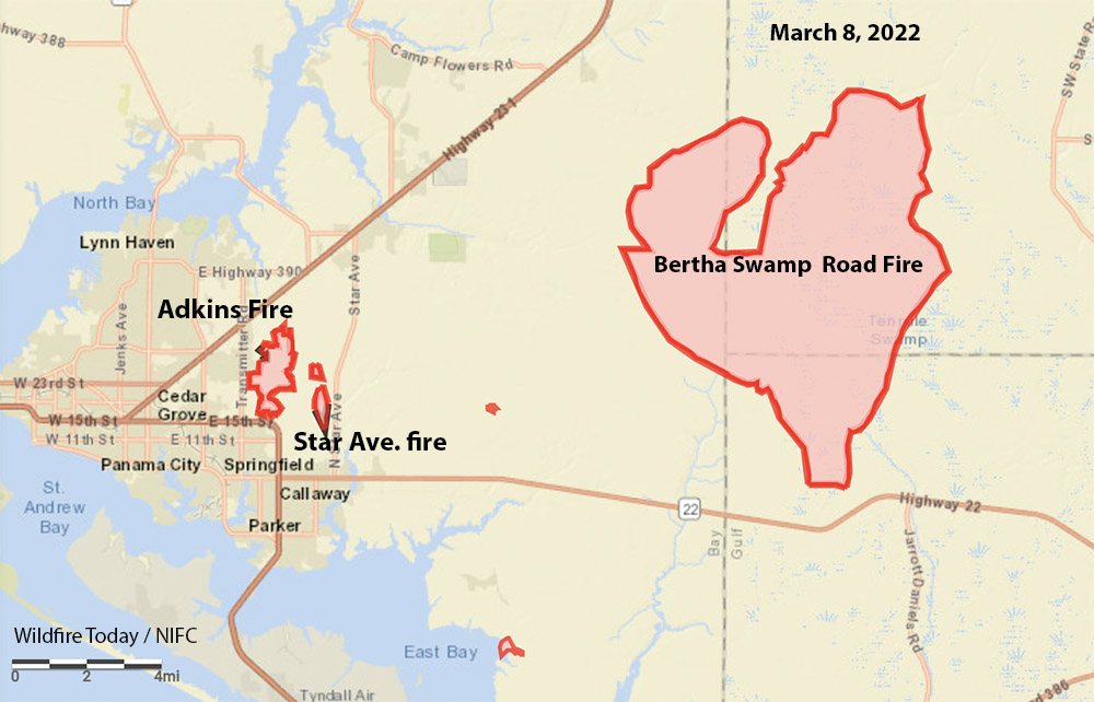
A large wildland fire about 10 miles east of Panama City, Florida has grown substantially in the last couple of days, doubling in size to about 28,000 acres according to the Florida Forest Service (FFS).
On Tuesday afternoon the rapid fire behavior prompted evacuations in the Broad Branch community near Kinard in Calhoun County.
While the weather forecast in the coming days calls for the possibility of rain, it will not be enough, the FFS said, to decrease the wildfire threat any time soon – especially in the Hurricane Michael-impact area.
Multiple pieces of heavy equipment battle the Bertha Swamp Road Fire. FFS photo.
The fire is part of the Chipola Complex of three fires east of Panama City. The other two are the Adkins Avenue Fire and the Star Avenue Fire. Both of those are nearing containment the agency said. Evacuation orders associated with these two wildfires have been lifted.
The FFS Blue Incident Management Team has assumed command of the Chipola Complex.
Florida Forest Service wildland firefighters and resources from countless other fire and emergency service departments are working around the clock to suppress the wildfires and protect communities. “We are truly grateful for all partners and their support in this fight. We will not back down,” the FFS said in a statement Tuesday evening.
The blazes are fueled by thick, dry vegeation and dead trees left behind after Hurricane Michael in 2018.
On Monday the resources working on the fire included more than 70 tractor-plow units and 10 air assets, including 2 FFS helicopters, 2 FFS fixed-wing aircraft, 2 Florida National Guard Black Hawk helicopters, 2 Florida National Guard Guard Chinook helicopters, and 2 Southeastern Compact single-engine air tankers (SEATS).
Dozers on the Bertha Swamp Road Fire, Florida, March 7, 2022. FFS photo.
Additionally, a strike team of heavy bulldozers is focusing on building firelines and defensible space around the communities near Bear Creek. The dozers are better equipped to move large volumes of debris and to establish wider firelines than typical initial attack tractor-plow units.
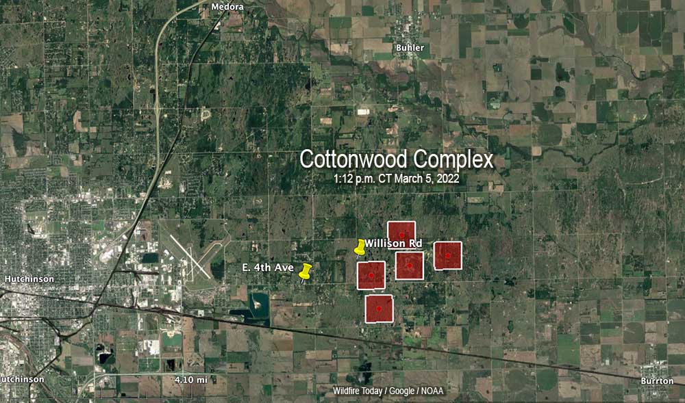
Approximately 30 air miles northwest of Wichita, Kansas
5 p.m. CT March 5, 2022
The red squares represent the approximate location of heat detected by a satellite at the Cottonwood Complex of fires, 1:12 p.m. CT March 5, 2022. The fire is east of Hutchinson, Kansas.
A wildfire that was reported east of Hutchinson, Kansas at about 12:30 p.m. Saturday has prompted evacuations. It started in the 800 block of Willison Road in Reno County and later spread east into Harvey County.
From The Hutchinson News:
“With Catastrophic Fire Danger and wind gusts upwards of 40 mph, firefighters had their hands full on arrival,” said Chief Doug Hanen, chief of operations for the Hutchinson Fire Department, at a 4:30 p.m. press briefing. “Units immediately engaged in structure protection and assisting residents in evacuating.”
The fire eventually crossed Buhler Road and spread rapidly through the Cottonwood Hills Golf Course, Hanen said. Winds then shifted to the west, making multiple fire fronts.
In the area of Fourth Avenue and Palamino Road, fire crews rescued several people from their homes or cars, but some residents also refused to evacuate.
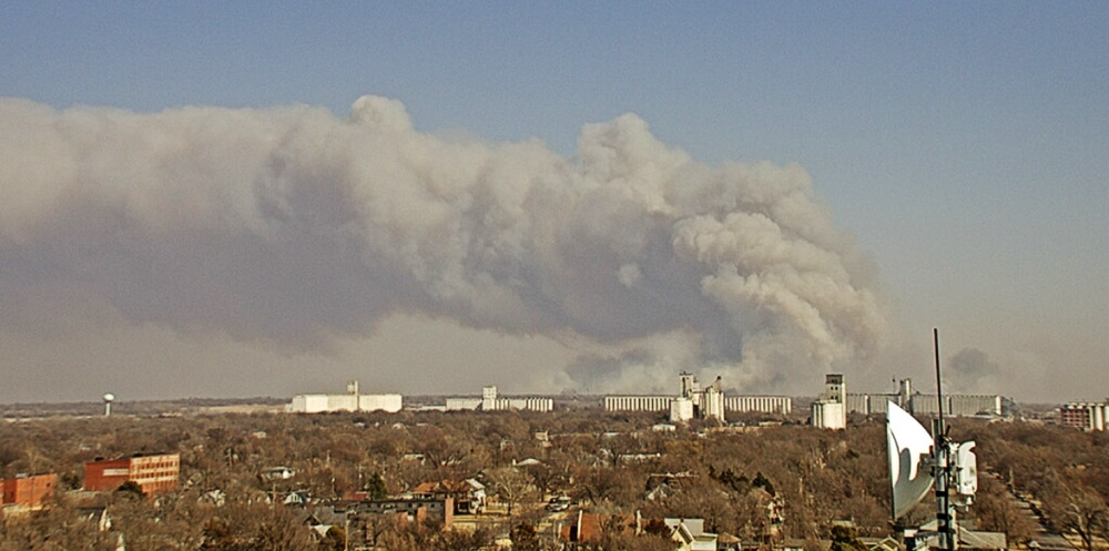
Fire east of Hutchinson, Kansas, at 1:55 p.m March 5, 2022. Image from First National Bank-Hutchinson camera.
There are reports that multiple homes were damaged or destroyed and several residents suffered burns.
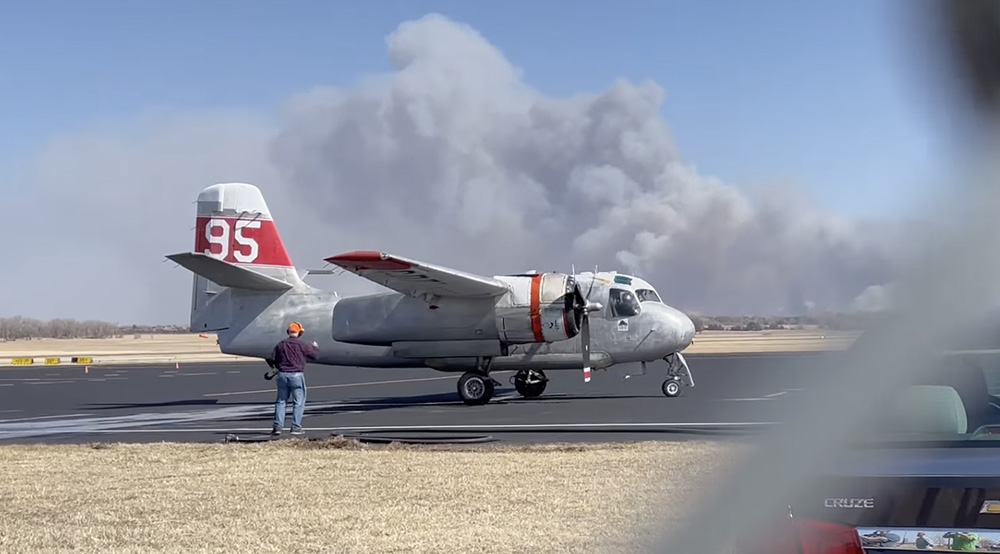
The Kansas Forest Service mobilized an air tanker, Tanker 95, a privately owned S-2 formerly operated by the California Department of Forestry and Fire Protection. It is now based in Kansas.
Air Tanker 95, an S-2, comes in for reloading with water after battling the Cottonwood Complex of fires east of Hutchinson, KS, March 5, 2022. Image by Heath Hensley.
The Kansas Division of Emergency Management has activated two UH-60 Black Hawk helicopters from the Kansas Army National Guard to assist firefighters beginning Sunday. The helicopters will have external water buckets.
Gov. Laura Kelly issued a verbal declaration of disaster emergency March 3, due to the potential for wildland fires in the state on Friday and Saturday. The declaration allows the state to preposition aerial firefighting assets from the Kansas Forest Service for a quicker response to any fires that may begin.
The video below shows Tanker 95 arriving to be reloaded with water. Smoke from the fire can be seen in the background.
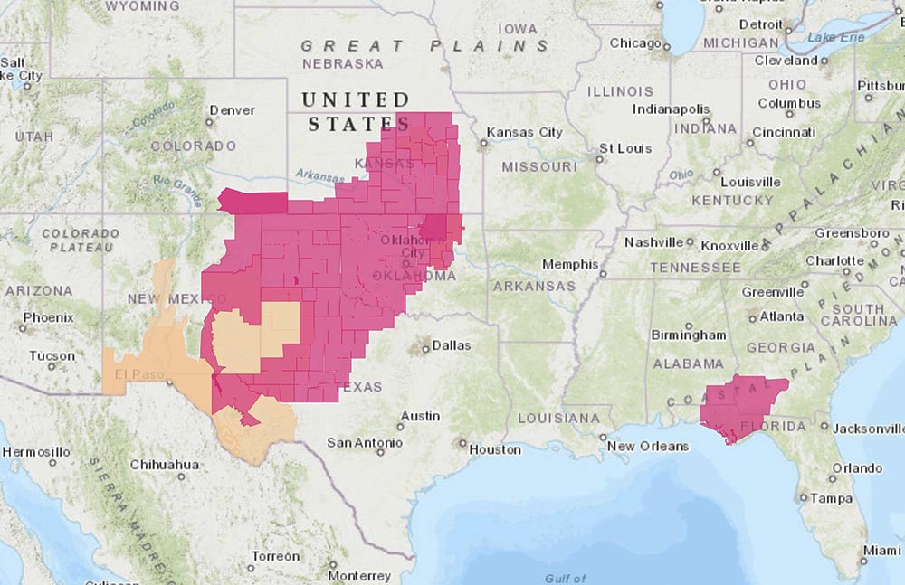
The area is under a Red Flag Warning on Saturday. Strong winds were predicted to come out of the west at 25 to 35 mph with gusts to 50 mph, with relative humidity as low as 10 to 15 percent.
Red Flag Warnings, March 5, 2022. NWS.
On February 8 another fire in the same general area ran for about two miles pushed by winds gusting at more than 30 mph. Shortly after it started Fire Marshal Michael Cain was investigating to determine if it was caused by embers from some of the 75 brush piles that were ignited on private land.
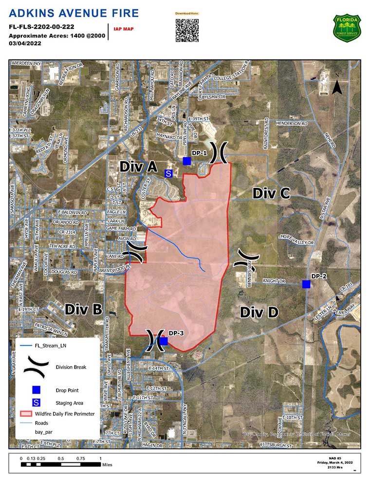
A fire on the east side of Panama City, Florida prompted the evacuation of about 600 homes, according to the Florida Forest Service (FFS). As of Friday evening the Adkins Avenue Fire had burned 1,400 acres in Bay County between U.S. 231 and Tram Road, west of North Star Avenue. The blaze is fueled by vegetation that was affected by Hurricane Michael in 2018.
Friday night the FFS reported that two structures have been destroyed and another 12 were damaged.
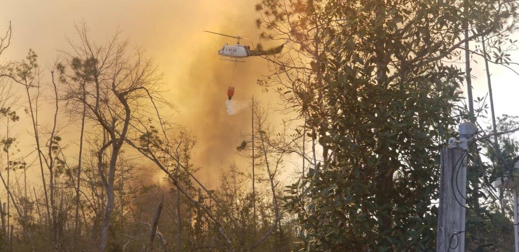
Helicopter drops water on the Adkins Avenue Fire. Photo: Bay County Emergency Services.
At least 200 personnel are committed to the fire including 12 tractor plows and multiple helicopters along with fire personnel from local and county departments.
Red Flag Warnings, March 5, 2022. NWS.
The area is under a Red Flag Warning until Saturday evening for 10 to 15 mph southeast winds gusting to 25 mph with relative humidity of 25 to 45 percent.
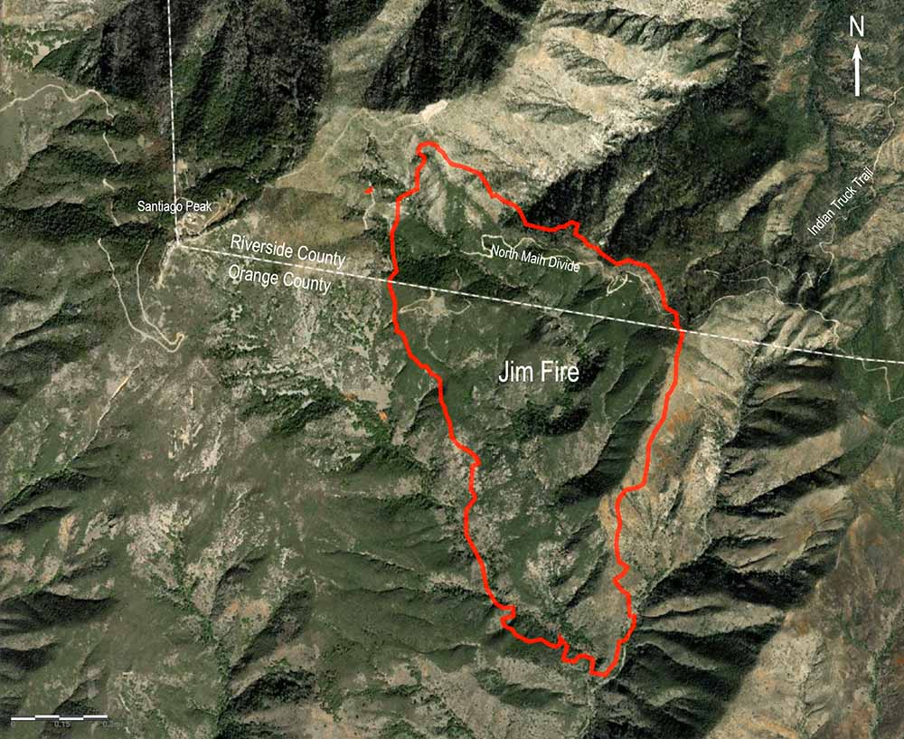
Firefighters are making good progress on the Jim Fire in the Cleveland National Forest in Southern California. On Thursday several air tankers and helicopters were assisting firefighters. There has been no mention of the fire spreading any more Thursday.
There has been no reported change in the size, and is still 553 acres.
The cause of the fire is officially still under investigation, but the Desert Sun reported that U.S. Marines were working with explosives in the general area about the time the fire broke out.
From the Sun:
Marine engineers from Camp Pendleton were in the area using explosives to demolish old dams, authorities said, as part of a long-running project to restore creek habitat for steelhead trout.
“There was a crew working in the area yesterday, but the fire is still under investigation,” said Nathan Judy, spokesperson for the Cleveland National Forest. “Forest Service law enforcement will be headed into that area to do the investigation.”
The video below from the FIRIS aircraft shows an air tanker dropping, and using infrared, the amount of heat remaining on the fire.
OCFA’s FIRIS Intel 12 on the Jim Incident showing retardant dropping on the Mike/Zulu Divisions. pic.twitter.com/7KBDccKmZO
The Jim Fire that started near Holy Jim Canyon spread very little after the late afternoon on Wednesday. The Cleveland National Forest said Thursday morning it has burned 553 acres. Today crews will continue to build hand and dozer lines around the fire and utilize water-dropping helicopters to assist with any remaining hotspots. Air tankers will be on standby to respond if needed.
It began in Orange County in Southern California Wednesday morning and burned uphill and north across the North Main Divide Truck Trail and into Riverside County.
As you can see in the photo below the fire is fairly quiet Thursday morning, with some interior heat still present.
Jim Fire, looking east-southeast from Santiago Peak at 8:42 a.m. March 3, 2022.
The thermal video below shows heat on the fire at 10:32 p.m. on Wednesday.
OCFA’s FIRIS Intel 12 showing a more detailed view at the head of the Jim Incident at 22:32 hours. pic.twitter.com/IkEwWf4ZYs
Fires in the Corrientes province of Argentina. The red dots represent heat detected by a satellite between Feb. 13 and 16, 2022. NASA/FIRMS/NOAA.
Residents in the Corrientes province of Argentina are hopeful that light rains over the weekend that are predicted to continue for a few days will slow the numerous wildfires that have been burning in the area for months.
Drought, low humidities, and a record-setting heatwave have created conditions in the northeast part of the country that has made it difficult to suppress the widespread fires, some of which started in December. Officials estimate that more than 1.5 million acres have burned, including areas near Iberá National Park.
On February 7, 2022, the governor of Corrientes declared a state of emergency and an agricultural disaster, retroactive to January 1. The same day, the National Institute of Agricultural Technology (INTA) estimated that the fires had affected roughly 6 percent of the province, which lies between the Paraná and Uruguay rivers near the border with Paraguay.
The growth of some of the fires can be linked to a non-native species, northern pine planted in the 1970s on abandoned areas formerly used for grazing after the old-growth forests had been logged. The government subsidized the conversion to the fast-growing pines to benefit the timber industry.
One species planted was radiata pine which is more flammable than the native trees. It has serotinous cones which open and disperse seeds after they are exposed to heat from fires. The resulting seedlings out-compete the native species so the diversity of the forest decreases and becomes more susceptible to fires. Rinse-repeat.
The video below from the Australian Broadcasting Corporation was published February 21, 2022.
Airport Fire, photo posted at 11:27 a.m. PT Feb. 17, 2022 by @captain2500agl
The growth of the Airport Fire slowed substantially by mid-day Thursday, judging from photos taken in the morning and afternoon. There are still a few residual smokes showing in the image shot by the camera on Marzano Peak at 1:56 p.m., but no dark gray columns.
Airport Fire, from the Marzano Peak camera at 1:56 p.m. Feb. 17, 2022 looking west-southwest.
Caltech, the operator of the Owens Valley Radio Observatory, said that as of Thursday morning at 11 a.m. personnel were reporting that a perimeter had been established around buildings and the main threat to the structures had passed. Assessment of instrumentation and antennas in the field surrounding the main facility structures, however, was ongoing.
The #AirportFire in California’s Eastern Sierra near the town of Big Pine is currently 3900 acres, 0% contained, and threatening the area near the Owens Valley Radio Observatory, a place near and dear to my heart. ? pic.twitter.com/BesGIxVrr5
CAL FIRE said at 9:53 a.m. Thursday that the Airport Fire had burned 3,900 acres.
Updated 9:47 a.m. PT Feb. 17, 2022
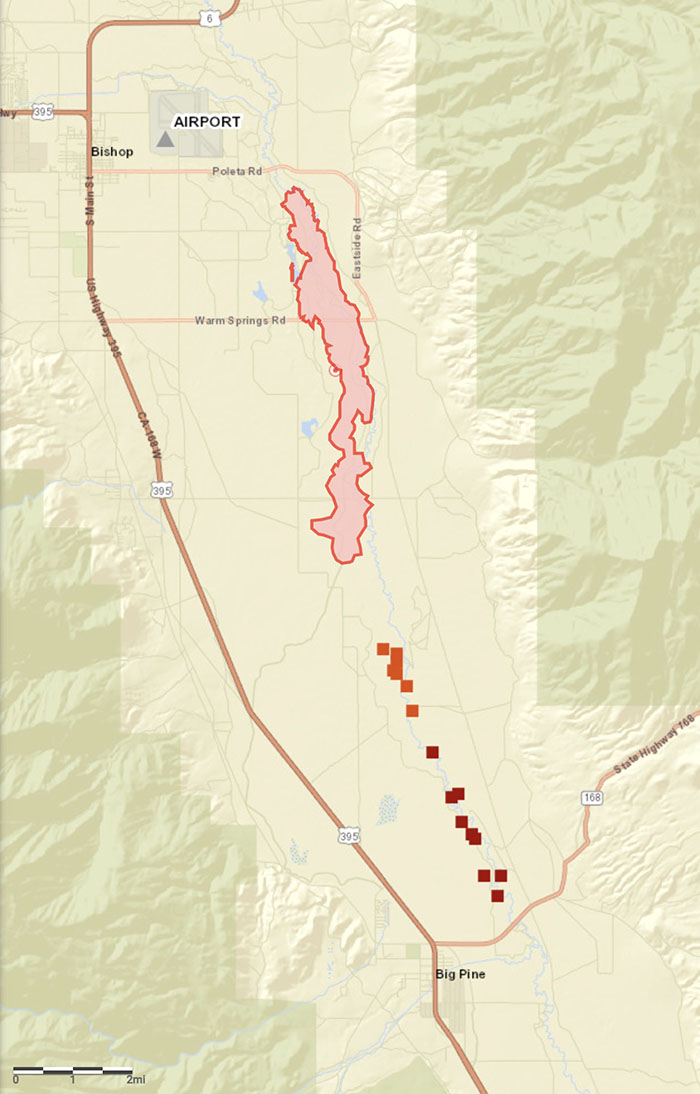
Map, Airport Fire. The red area shows the location of the fire mapped Wednesday afternoon by FIRIS. The red squares represent heat detected by a satellite at 8 a.m. PT, Feb. 17, 2022.
The map of the Airport Fire above is more accurate than our earlier map.
9:10 a.m. PT Feb. 17, 2022
Map of the Airport Fire showing heat detected by a satellite as late as 2:15 a.m. Feb. 17, 2022. The yellow dots exaggerate the extent of the fire, at least in its width. Many of the yellow dots are very questionable. The red dots appear to be more accurate. The gap between the yellow and red dots is likely the result of the light vegetation burning and cooling between the two satellite passes, which were about 11 hours apart.
The Airport Fire was very active Wednesday night. When the sun rose Thursday it spanned for about 13 miles from the airport in Bishop, California south to Big Pine. CAL FIRE reports that evacuations have been ordered for properties in Big Pine that are east of US Highway 395. The town has a population of about 1,500.
CAL FIRE dispatched six S-2 air tankers Thursday at about 8 a.m.
Areas that are threatened include two research facilities, White Mountain Research Center and Owens Valley (Caltech) Radio Observatory. Both were evacuated Wednesday.
The blaze started Wednesday afternoon near the Eastern Sierra Regional Airport at Bishop.
Photos taken from Marzano Peak early Thursday morning showed active fire near Big Pine. In the southernmost area of the fire dense, dark smoke was visible which could indicate heavy fuels, such as structures or vehicles burning.
Airport Fire, from the Marzano Peak camera at 6:15 a.m. Feb. 17, 2022 looking west-southwest.Airport Fire, from the Marzano Peak camera at 9:07 a.m. Feb. 17, 2022 looking west-southwest.
The wind, which on Wednesday was out of the north at 28 mph gusting up to 50 mph, slowed during the night but was still strong, 15 to 22 mph gusting at 26 to 32 mph with the relative humidity in the mid-30s. At 8:20 a.m. Thursday the Big Pine weather station recorded 15 mph north-northwest winds gusting to 21 mph while the relative humidity was 40 percent.
The forecast for Big Pine on Thursday is for 56 degrees, 16 percent relative humidity in the afternoon, and 10 to 14 mph winds out of the northwest gusting until noon at 20 mph. These conditions will be conducive to active spreading of the fire, as long as the fuel is continuous.
Resources assigned to the fire Thursday morning include 66 fire engines, 7 water tenders, 1 helicopter, 16 hand crews, and 7 dozers for a total of 432 personnel.