West Wind Fire burns grain elevators and dozens of structures in Denton, Montana

Grain elevators burn in Denton, Montana
Grain elevators burn in Denton, Montana Dec. 1, 2021. Fergus Co. Sheriff Office photo.

9:11 a.m. MST Dec. 3, 2021

The Fergus County Fire Warden, Ryan Peterson, said on December 1 that a power line was the suspected cause of the fire that destroyed grain elevators and 25 homes in Denton, Montana that day. Winds gusting up to 65 mph pushed the fire, spreading for 18 miles from Highway 80 to the east well past Denton.

The Opportunity Bank of Montana has started a donation drive to assist victims and evacuees. Checks can be made payable to the Denton Fire Relief Fund and mailed to the bank at PO Box 1047, Denton, MT 59430.

The state of Montana mobilized a County Assist Team and helicopters to aid in the suppression and recovery from the fire.

At the Coffee Creek N weather station northwest of Denton the high temperature recorded on December 1 when the fire burned through the town was 66 degrees at 1 p.m., with a minimum relative humidity of 37 percent. The maximum sustained wind speed and wind gust that day occurred at the same time — 41 mph gusting to 65.

The temperature was 30 degrees warmer than normal. According to Accuweather the average high temperature for Denton on December 1 is 36 degrees. The forecast for today, Friday December 3, is a high of 40 degrees with a 25 percent chance of snow Friday night.

Earlier this week new records were set in Montana and other western states for daily and monthly high temperatures.


7:46 p.m. MST Dec. 2, 2021

Grain elevators and 25 homes burned in Denton, Montana Wednesday December 1 as a large wildfire burned through the town, the Fergus County Sheriff’s office said.

The West Wind Fire was reported at 11:14 p.m. Tuesday Nov. 30 near Highway 80. Pushed by 24 to 40 mph winds gusting out of the west up to 60 mph hour it quickly spread east from Judith Basin County into Fergus County. On Wednesday Dec. 1 it burned into Denton, population about 300, and destroyed grain elevators, bridges, and 25 residences. The Sheriff’s Facebook page has a list of the affected homes.

West Wind Fire map Dec. 2, 2021
West Wind Fire map Dec. 2, 2021.

The wind was too strong on Wednesday for aircraft to assist firefighters.

The town was evacuated and there were no reports of serious injuries or fatalities. The Sheriff expected to lift the evacuation order Thursday afternoon. Highway 81 west of Denton is closed due to a bridge that burned.

The fire was no longer spreading on Thursday after burning  10,644 acres.

There has been record setting heat in Montana in recent days.

High temperatures in the West

The wildfire potential in central Montana is predicted to be higher than average in December.

December fire weather outlook

Do not drive into a flooded street. Do not drive into a fire.

Wildfire north of Honolulu threatened structures

And, the aircraft formerly known as the SuperTanker was spotted in Hawaii

Wildfire north of Honolulu, Nov. 26, 2021
Wildfire north of Honolulu, Nov. 26, 2021. Photo by Hiroshi Ando.

The day after Thanksgiving, November 26, a wildfire north of Honolulu, Hawaii threatened structures near Kalana Drive and Alu Street. After the report was received around noon 12 pieces of apparatus staffed with about 34 personnel responded.

Two helicopters owned by the City and County of Honolulu assisted firefighters by dropping water that was dipped out of a swimming pool at Kalihi Valley District Park.

Wildfire north of Honolulu, Nov. 26, 2021 helicopter drops water
MD 500N helicopter, owned by the City & County of Honolulu, working on a wildfire north of the city. Photo by Hiroshi Ando, Nov. 26, 2021.

In a news release the Honolulu Fire Department described the fire as “large scale, rapidly spreading” driven by wind. They said it burned about four acres.

Wildfire north of Honolulu, Nov. 26, 2021 helicopter drops water
MD 500N helicopter, owned by the City & County of Honolulu, dips water out of a swimming pool while working on a wildfire north of the city. Photo by Hiroshi Ando, Nov. 26, 2021.
Wildfire north of Honolulu, Nov. 26, 2021 helicopter drops water
MD 500N helicopter, owned by the City & County of Honolulu, working on a wildfire north of the city. Photo by Hiroshi Ando, Nov. 26, 2021.

It is dry in Hawaii. The Drought Monitor classifies conditions in the state as ranging from abnormally dry to exceptional drought.

Hawaii Drought Monitor, Nov. 23, 2021

These photos were taken by Hiroshi Ando who was one of the drop system operators on Global SuperTanker Services’ 747 SuperTanker. Earlier this year the company shut down and sold the aircraft to National Airlines, who re-registered it as N936CA and is using it as a freighter. Hiroshi shot the photo below earlier this month when the aircraft was in Hawaii. He said he has spotted the plane a few times there while it was flying on military cargo flights.

N936CA, formerly Tanker 944
N936CA, formerly Air Tanker 944, now owned by National Airlines. Photographed in Hawaii by Hiroshi Ando Nov. 4, 2021.

Hiroshi said the fire north of Honolulu started about four hours after Coulson’s C-130 Air Tanker 131, N131CG, departed Hilo after the crew stopped to spend the night on their ferry flight from the US West Coast on their way to begin a firefighting contract in Australia for the country’s 2021/2022 bushfire season.

In 2018 Hiroshi sent us photos he took of the Holy Fire while the SuperTanker was working on the fire which burned more than 22,000 acres northwest of Lake Elsinore, California.

DNA analysis of a tree leads to sentence of 20 months in prison for timber theft

The jury did not convict the defendant of starting the 3,300-acre Maple Fire in the Olympic National Forest

Maple Fire Olympic National Forest
Maple Fire, Olympic National Forest, Washington, 2018. IMT photo.

The lead defendant in a scheme to unlawfully harvest maple trees from the Olympic National Forest that resulted in the 3,300-acre Maple Fire in 2018 was sentenced November 8 to 20 months in prison. Justin Andrew Wilke, 39, was convicted in July 2021 of conspiracy, theft of public property, depredation of public property, trafficking in unlawfully harvested timber, and attempting to traffic in unlawfully harvested timber.

Maple trees are so valuable and prized by woodworkers, especially those who manufacture musical instruments, that it is a violation of the law in Washington to transport the wood without a state-issued specialized forest products permit. Armed with a permit that authorized the harvesting of maples from private land, Justin Andrew Wilke and Shawn Edward (Thor) Williams and others camped for several days in the Olympic National Forest scouting for big leaf maple trees with the highly desired figured wood pattern. They identified trees containing figuring by “checking” the trees, that is, using an axe to peel back the bark to expose the pattern of the wood, sometimes doing it at night to avoid detection.

When they found a tree they liked they would fell it with a chain saw, buck it up, and transport the wood to a mill in Tumwater, Washington, presenting the permit and saying it had been harvested with permission from private property. According to the federal grand jury indictment, Wilke and/or Williams made more than 20 trips to the mill between April and August of 2018, collecting more than $13,000 by selling illegally harvested National Forest timber.

This prosecution was the first use of tree DNA evidence in a federal criminal trial. At the trial, a Research Geneticist for the USDA Forest Service testified that the wood Wilke sold was a genetic match to the remains of three poached maple trees investigators had discovered in the Elk Lake area. The DNA analysis was so precise that it found the probability of the match being coincidental was approximately one in one undecillion (one followed by 36 zeroes). Based on this evidence, the jury concluded that the wood Wilke sold the mill had been stolen. The DNA evidence also concluded that Wilke had unlawfully harvested and sold wood from seven additional maple trees – but the precise locations of those trees have not been determined.

Maple Fire Olympic National Forest
Maple Fire, Olympic National Forest, Washington, 2018. IMT photo.

On August 3, 2018, Wilke led a group of two other individuals in deciding to cut a maple tree that contained a wasp’s nest near the base of the tree. To remove the nest, the group sprayed insecticide and likely gasoline on the nest and then lit the nest on fire. The group failed to extinguish the fire, which developed into the Maple Fire which cost approximately $4.2 million to suppress.  The other two members of the poaching group testified at trial that Wilke was standing next to the nest when it was lit on fire, and therefore appeared to have set the fire. However, because the fire was set at night, they were not able to see his exact actions, and testified that they did not know exactly how the fire started. The jury did not convict Wilke of the two federal counts related to the forest fire: setting timber afire and using fire in furtherance of a felony. The jury did convict Wilke of attempting to cut down the tree where the fire was set on the night of the fire.

Prosecutors recommended a 36-month sentence, noting that Wilke led the three-person tree-poaching ring that indisputably started the fire, and that Wilke likely set the fire himself based on the testimony at trial. At sentencing, Judge Benjamin H. Settle concluded that the evidence was clear and convincing that Wilke was present when the fire was set, that a member of Wilke’s poaching crew set the fire, and that Wilke more likely than not personally set or directed one of his crew to set the fire. But Judge Settle noted that Wilke had made positive strides while on pretrial release, and that prison time is more difficult during the COVID pandemic. Judge Settle therefore imposed the 20-month sentence.

Wilke was also ordered to forfeit the proceeds of his illegal poaching. He will be required to pay restitution to the United States Forest Service. The exact amount will be determined at a later hearing.

Maple Fire Olympic National Forest
Maple Fire, Olympic National Forest, Washington, 2018. IMT photo.

Thanks and a tip of the hat go out to Greg.

Night-flying air tanker crashes while working on wildfire in Colorado

The pilot was killed

Updated at 4:56 p.m. MST Nov. 17, 2021

Wednesday afternoon CO Fire Aviation released a statement that identified the pilot who was killed Nov. 16 during a night-flying air tanker mission on the Kruger Rock Fire southeast of Estes Park, Colorado.

The CO Fire Aviation family is deeply saddened by the sudden, tragic loss of one of our brothers serving as a tanker pilot. Marc Thor Olson was a highly decorated veteran of both the Army and Air Force with 32 years of service to our country. During Thor’s 42 years of flight, he had amassed more than 8,000 total flight hours with an impressive 1,000 hours of NVG flight including in combat and civilian flight.

Co Fire maintains a close working relationship with multi regulatory agencies and is fully cooperating with the proper authorities and partners during this investigation.

While we are gravely aware of the inherent dangers of aerial fire fighting and the questions that remain; we ask that family and friends be given distance and time to process and heal as we grieve this loss. Your prayers are appreciated during this difficult time.

A preliminary map appears to show that the fire was just inside the boundary of the Roosevelt National Forest. The Larimer County Sheriff’s office said on Wednesday that as of 7 a.m. Wednesday the fire was managed by a unified command with the US Forest Service and the Sheriff. In Colorado the local county sheriffs are given the responsibility for suppressing wildfires outside of cities unless they are on federal land.

Map, Kruger Rock Fire
The map shows the approximate location of the Kruger Rock Fire. It is based heat detected by satellites as late as 1:40 p.m. MST Nov. 16, 2021. Clouds degraded the ability of satellites to obtain good quality data.

The crash occurred at about 6:35 p.m MST on Tuesday Nov. 16 while attempting to suppress the fire. This was about 1 hour and 49 minutes after sunset, and was the first time a fixed wing air tanker had dropped fire suppressant on a fire at night in Colorado.


11:29 p.m. MST Nov. 16, 2021

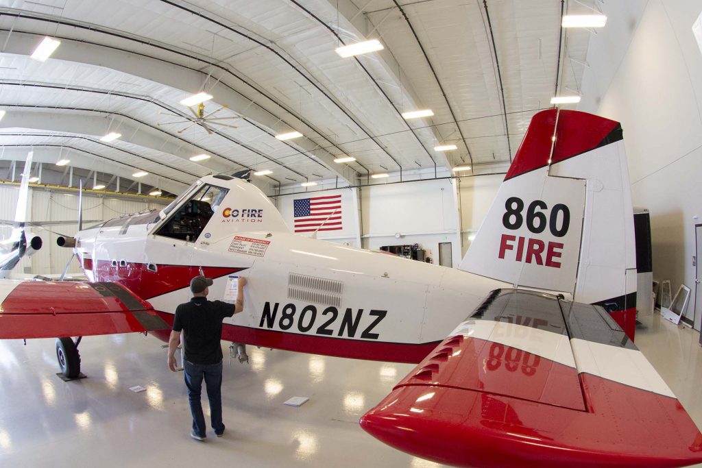
AT-802F single engine air tanker
File photo of the aircraft that crashed November 16, 2021. Air Tractor AT-802A, N802NZ, owned by CO Fire Aviation. Photo by Aviation Specialties Unlimited September, 2018.

An air tanker that was working the Kruger Rock Fire southeast of Estes Park, Colorado Tuesday night November 16 crashed, killing the pilot, the only person on board. The Single Engine Air Tanker (SEAT) had taken off from Northern Colorado Regional Airport, formerly known as the Fort Collins-Loveland Municipal Airport, at 6:13 p.m. MST Nov. 16 and disappeared from flight tracking 22 minutes later at 6:35 p.m. MST. Earlier in the day it departed from the Fort Morgan, Colorado airport, orbited the fire about half a dozen times, then landed at Northern Colorado Regional Airport at 4:38 p.m. MST.

The incident was first reported by KUSA, 9News in Denver. Marc Sallinger, reporter for the station, had interviewed the pilot earlier in the day, and wrote on Twitter, “My thoughts and prayers are with the pilot who took off tonight, so excited for this history-making flight. He told me ‘this is the culmination of 5 years of hard work.’ He showed me his night vision goggles and how they worked. He was so kind. Holding out hope for him.”

Eyewitnesses reported the crash at approximately 6:37 p.m., but in the dark it was very difficult to pinpoint the location. After three hours of searching, firefighters found it near the south end of Hermit Park. Unfortunately the pilot was deceased.

The aircraft was an Air Tractor 802A, registration number N802NZ, owned by CO Fire Aviation. In 2018 we wrote about the company’s efforts to configure this aircraft for fighting fires at night. Helicopters have been doing it off and on for decades, but a fixed wing air tanker dropping retardant on a fire at night is extremely rare. In 2020 and 2021 CO Fire Aviation had one of their SEATs working on a night-flying contract in Oregon. The company says they are the only operators of night-flying fixed wing air tankers.

Earlier this year a video was posted on YouTube that featured CO Fire Aviation conducting a night-flying demonstration at Loveland, Colorado. That segment begins at 8:15 in the video.

At 6 p.m. the Larimer County Sheriff’s office said the Kruger Rock Fire had burned about 133 acres. More information about the fire.

Our sincere condolences go out to the pilot’s family, friends, and coworkers.


The article was edited to show that the crash was first reported by KUSA, 9News in Denver.

Thanks and a tip of the hat go out to Tom.

Kruger Rock Fire prompts evacuations southeast of Estes Park, Colo.

Updated at 3:57 p.m. MST Nov. 17, 2021

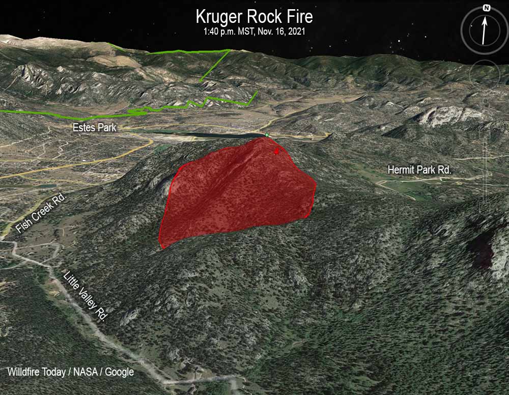
Map, Kruger Rock Fire 3D 140 p.m. MST Nov. 16, 2021
The map shows the approximate location of the Kruger Rock Fire. It is based heat detected by satellites as late as 1:40 p.m. MST Nov. 16, 2021. Clouds degraded the ability of satellites to obtain good quality data.

In Colorado the local county sheriffs are given the responsibility for suppressing wildfires outside of cities. The Larimer County Sheriff’s office has not released much more information about the Kruger Rock Fire since the pilot of a single engine air tanker was killed in a crash while attempting to suppress the fire at about 6:35 p.m MST on Tuesday Nov. 16. It occurred about 1 hour and 49 minutes after sunset, and was the first time a fixed wing air tanker had dropped fire suppressant on a fire at night.

Wednesday afternoon the operator of the aircraft, CO Fire Aviation, released the name of the pilot, Marc Thor Olson.

The Sheriff’s office said Wednesday morning that there were changes in the evacuation areas, which can be seen on their map. The size of the fire was estimated to be 140 acres.

An investigation into the cause of the fire has revealed high winds blew a tree onto a power line causing it to arc and start the fire.


4:50 p.m MST Nov. 16, 2021

Map, Kruger Rock Fire
Map showing the approximate location of the Kruger Rock Fire. The two red dots represent heat detected by a satellite at 11:06 a.m. MST Nov. 16, 2021.

A new wildfire in Colorado has prompted evacuations east of Rocky Mountain National Park.

The Kruger Fire was reported at about 7 a.m. near Little Valley Road and Fish Creek Road near Kruger Rock 3 miles southeast of Estes Park and 2 miles east of Mary’s Lake. It is about 3 miles east of Rocky Mountain National Park.

At 3 p.m. fire officials estimated it had burned 115 acres. There are 150 personnel currently working the fire with more ordered.

At about 1:10 p.m. local time the Larimer County Sheriff’s Office issued a mandatory evacuation order for the area between Pole Hill Road and Panorama Peak on the east side of Highway 36. An hour earlier the office had issued a mandatory evacuation order for the area of Meadowdale, and south to the Boulder County line, to include Big Elk Meadows and Pinewood Springs west of Highway 36.

The evacuation map below is available online.

Kruger Fire evacuation map
Kruger Fire evacuation map, 1:32 p.m. MST Nov. 16, 2021.

Colorado Highway 36 is closed in the area.

Kruger Rock Fire
Kruger Rock Fire. Image by Michael Warren the morning of Nov. 16, 2021.

Strong winds in the fire area have kept firefighting aircraft grounded, except for an intelligence-collecting Multi-Mission plane flying thousands of feet over the fire. The wind direction at a weather station just west of the fire (at 7,841 feet) was quite variable Tuesday, blowing from the south, west and north at 5 to 13 mph gusting at 25 to 34 mph. At noon it was 73 degrees with 26 percent relative humidity. The forecast for the fire area calls for continued very strong winds until sundown and a chance for snow Tuesday night. It will be dry Wednesday and Thursday with high temperatures in the 30s and 40s under mostly sunny skies with the relative humidity around 20 percent. The wind chill will be below zero from Wednesday afternoon until Thursday afternoon.

Officials estimate hundreds of giant sequoias were killed in the Windy Fire

Giant sequoia trees can live for up to 3,000 years

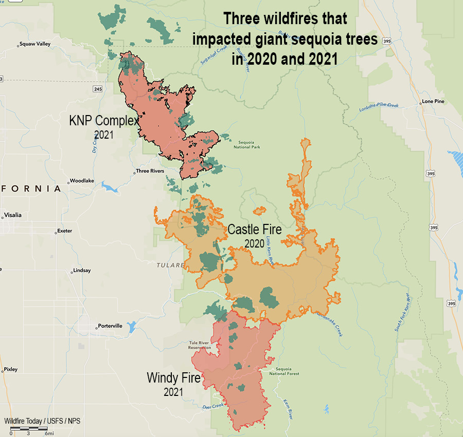
Three Fires, giant sequoia trees
Three fires in two years that killed giant sequoia trees. The darker green areas represent groves of giant sequoias.

11:30 a.m. PDT Nov. 4, 2021

Giant sequoia trees can live for up to 3,000 years, but in 2020, 10 to 14 percent of all giant sequoias in the Sierra Nevada that were at least four feet diameter were killed in the Castle Fire in the Sequoia National Forest. When post-fire surveys of the 2021 fires are complete that number will probably increase substantially. It will be many months before detailed surveys are complete, but the sequoia mortality can be estimated from how severely the fire burned.

The lightning-caused 97,528-acre Windy Fire just south of the Castle Fire (see map above) burned into eleven giant sequoia groves in September and October, 2021. The Forest Service is working to determine the impacts of the fire in the groves managed by the Forest Service. The agency said on November 2 that initial assessments based on observations by resource advisors and burn severity analysis indicate the fire killed hundreds of giant sequoias. Many more were heavily torched and may or may not survive.

A report released June 25, 2021 about the 2020 Castle Fire found that areas which burned with high intensity killed many giant sequoias. The data showed 97.3 percent mortality of the trees in high fire severity areas, and 55.1 percent in moderate severity locations.

Preliminary fire severity data is now available for a portion of one of the two 2021 fires that burned through groves of giant sequoias, in this case, Giant Sequoia National Monument in the Windy Fire.

2021 KNP Complex, BAER report on burn severity

Using the fire severity data for the portion of the Windy Fire in Giant Sequoia National Monument, if there was only one giant sequoia per acre before the fire, approximately 1,142 were likely killed. However, there were probably far more than one per acre.

While numerous fires were burning in 2021 in California there was a shortage of firefighters due to unfilled positions in the US Forest Service, COVID-19 restrictions keeping some on the sidelines, and competition for resources among the fires. The limited numbers that were available worked on suppressing the spread of the fires, and on the Windy and KNP Complex they also took actions to protect the huge sequoias as personnel were available.

Sequoia burn severity
Drone imagery of moderate severity patches within the large high severity patch of Redwood Mountain Grove. Because surviving trees in these patches could be limited, the acreage calculation for distance to live tree excluded these for the regeneration analysis (Paul Hardwick, personal communication). Orange squares are classified as moderate severity.

In some areas, they constructed firelines surrounding a grove or individual groups of trees, set up sprinkler systems, and removed ladder fuels from around individual trees in advance of the fire. After the fire burned through, additional efforts were made to further reduce the fire’s impact on giant sequoia trees by extinguishing hot spots in and around the trees, again, as personnel were available.

The US Forest Service said that from initial observations, it was apparent that giant sequoia trees treated before the Windy Fire swept through were more likely to survive. Those with duff and woody debris scraped away from their trunks, especially near burn marks, were less susceptible in most cases. In the Starvation Complex grove, four out of six giant sequoia trees treated before the fire reached them, survived. An estimated 116 trees not accessible before the fire, were killed. Similar conditions were found in the Long Meadow Grove, where more than a decade of fuels reduction efforts helped save the giant sequoia trees along the Trail of 100 Giants.

“Within the high severity burned areas, most of the giant sequoias were burned and killed,” said Forest Ecosystem Manager Gretchen Fitzgerald. “In moderate severity areas, some giant sequoias may survive while those in low severity burned areas are likely to survive the Windy Fire.”

The Sequoia National Forest will be partnering with researchers and local experts to monitor the groves and determine the impacts of the Windy and Castle Fires over the next year.

“Recent fires highlight the need for restoration in the giant sequoia groves,” stated Forest Supervisor Teresa Benson. “By reducing fuels through prescribed burning and other density-reduction treatments, the likelihood of future large, high-severity fires can be reduced. The Giant Sequoia National Monument Management Plan requires protection, preservation, and restoration of giant sequoias through management activities. We will continue to work with our partners, Tule River Indian Reservation, National Park Service, Save the Redwoods League, and CAL FIRE on best management practices to protect and restore our giant sequoia groves.”