
The strong winds in New Mexico and Arizona are indicated by the trajectory of the smoke plumes from the wildfires.

News and opinion about wildland fire

The strong winds in New Mexico and Arizona are indicated by the trajectory of the smoke plumes from the wildfires.
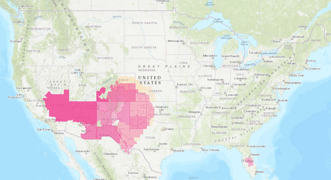
In the cross hairs are New Mexico, Kansas, and Nebraska
12:21 p.m. MDT May 8, 2022
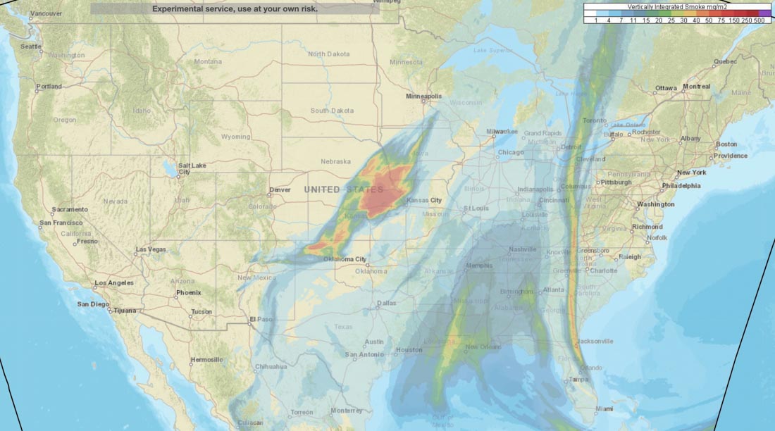
Above is a map from NOAA showing the distribution of vertically integrated smoke from wildfires at 11 a.m. MDT May 8, 2022.
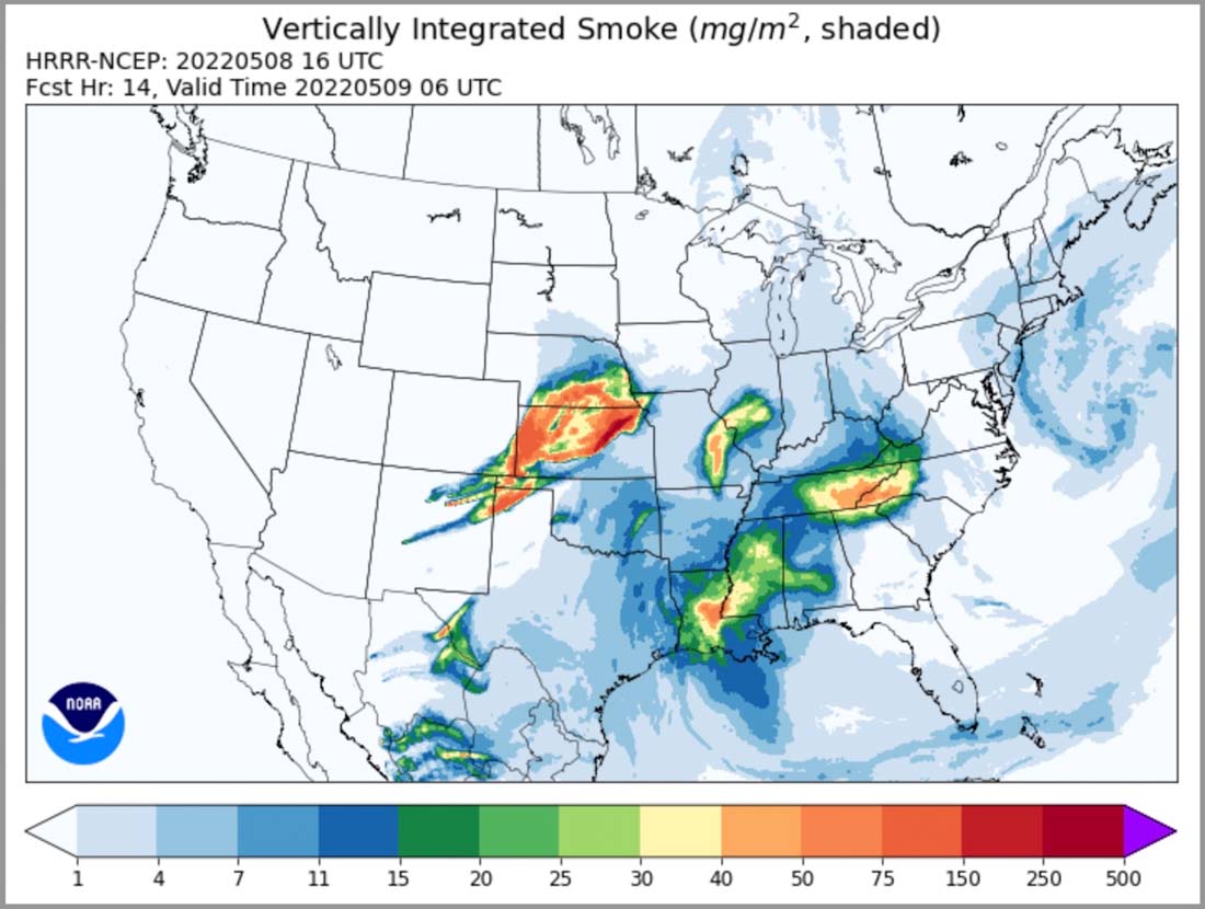
Below is the forecast for smoke at 12:01 a.m. MDT May 9, 2022.
The map below shows the areas under Red Flag Warning for elevated wildfire danger.
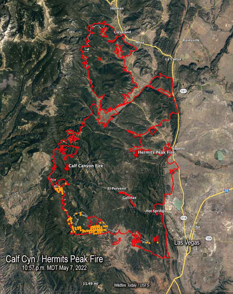
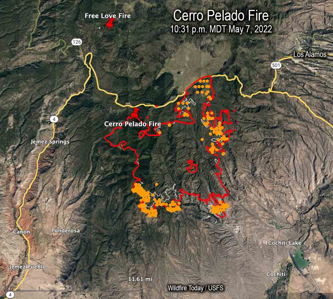
Calf Canyon / Hermits Peak and Cerro Pelado Fires
Updated at 12:15 p.m. MDT May 9, 2022
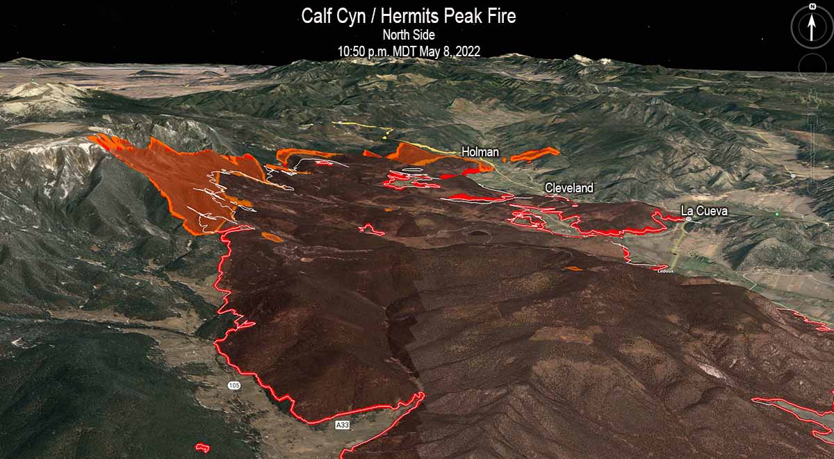
Updated to add the 3-D map of the north end of the Calf Canyon / Hermits Peak Fire.
To see all articles on Wildfire Today about the Calf Canyon / Hermits Peak Fire, including the most recent, click here.
Updated at 9:23 a.m. MDT May 9, 2022
Both of the large wildfires in Northern New Mexico were very active Sunday, pushed by the very strong winds.
Cerro Pelado Fire
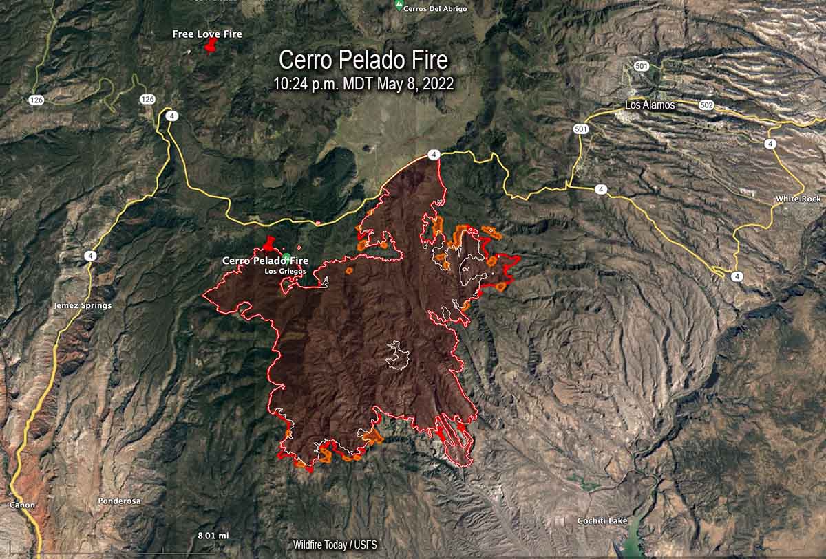
The most significant spread of the Cerro Pelado Fire Sunday was on the northeast side south of Highway 4 where it spread for about a mile east and crossed the FR 289 road. When the fire was mapped at 10:24 p.m. Sunday a large spot fire had come very close to crossing the next road to the east, FR 287. The fire grew by more than 3,000 acres Sunday to bring the size up to 40,958 acres.
Calf Canyon / Hermits Peak Fire
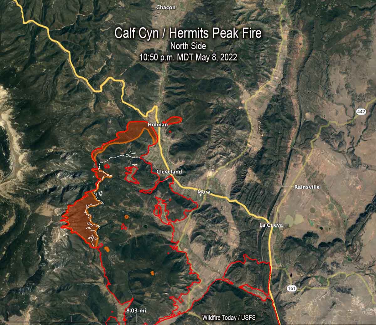
Most of the significant growth on the Calf Canyon / Hermits Peak Fire was on the north and south sides. When it was mapped at 10:50 p.m. on Sunday the north side, northwest of Cleveland, had advanced for about two miles further north coming close to Holman. There was a large 200-acre spot fire across Highway 518 east of Homan.
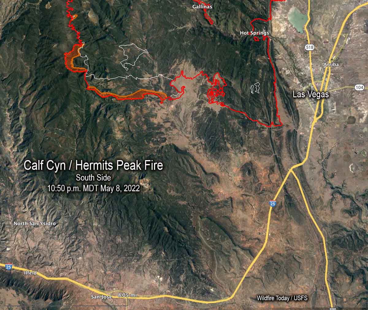
The east side of the Calf Canyon / Hermits Peak Fire still appears to be secure and the Sunday night map showed no change south of Mora and La Cueva near Highway 518. There was also no change near Las Vegas. But about 8 miles west of Las Vegas south of Highway 283 it spread south for an additional mile.
The fire grew by more than 13,000 acres Sunday to bring the size up to 189,767 acres.
Updated at 7:13 p.m. MDT May 8, 2022
Calf Canyon / Hermits Peak Fire
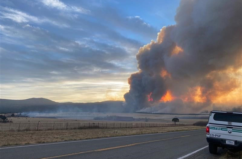
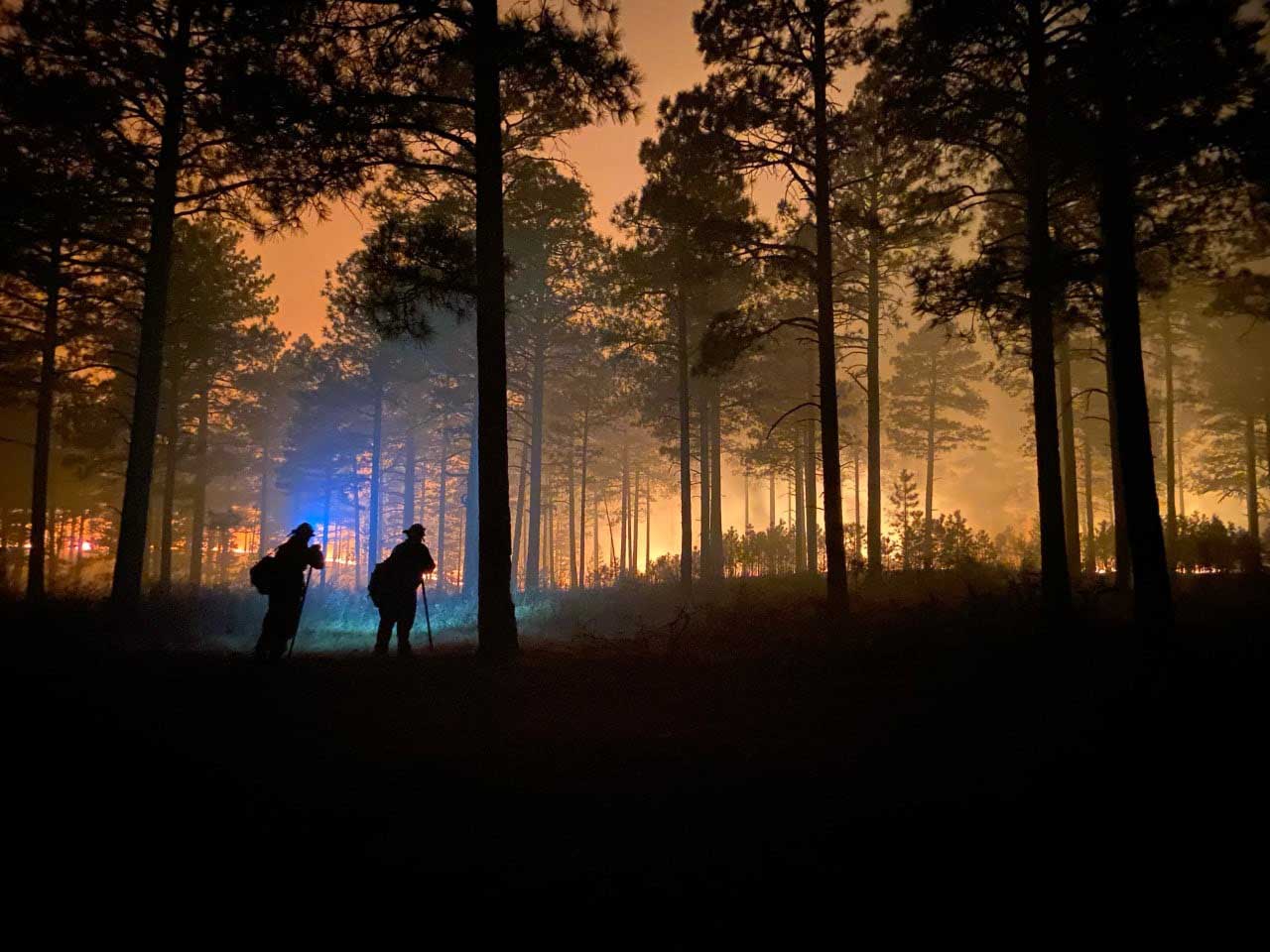
The Calf Canyon / Hermits Peak Fire near Las Vegas, New Mexico made it through Saturday’s wind event without any major devastating runs beyond the existing firelines, but it is not over yet. Red Flag Warnings are again in place Sunday for strong winds, low humidity, and very dry vegetation. The forecast for Sunday and Monday is for sustained 32 mph winds gusting out of the west-southwest at 40 to 48 mph with 8 percent relative humidity.
Operations Section Chief Todd Abel said Saturday evening that one of the most active areas on the fire was on the southwest side near Highway 283. He also said all aircraft working on the fire had to be shut down around noon Saturday when the winds became too turbulent.
The fire has burned 176,000 acres.
Cerro Pelado Fire
On Friday and Saturday most of the spread of the Cerro Pelado Fire was on the northeast side south of Highway 4, and on the southwest side. The 37,525-acre blaze is seven miles west-southwest of Los Alamos, New Mexico.
On the eastern side of the fire the FR 289 road is considered a primary line as the fire continued to advance in that direction pushed by 35 mph winds. A spot fire crossed the road late Saturday afternoon. Crews working that night shift described conditions in the area as “unbearable” due to wind, dust, smoke, and heat. Crews later engaged the spot fire at 3:00 a.m. Sunday when visibility had improved. Most of the movement to the east occurred in steep canyons. FR 289 has been prepped and plumbed with extensive hose lines.
Crews are coordinating with the National Park Service for structure protection in Bandelier National Monument and Valles Caldera National Preserve.
A Red Flag Warning is in effect for Sunday. The forecast for the fire area is for 39 mph winds gusting out of the west-southwest at up to 55 mph with relative humidity as low as 9 percent. On Monday the wind speeds will drop to 24 mph with gusts of 31 to 39 mph from the west-southwest.
Most of the blaze is in the footprint of the Las Conchas Fire that burned 156,593 acres in 2011. In a trial jurors found that two power companies were 95 percent responsible for starting that fire and the U.S. Forest Service was 5 percent responsible. The cause of the current Cerro Pelado Fire is listed as unknown.
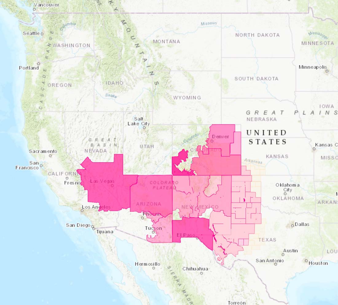
An analysis of their pay and costs of living found that federal wildland firefighters can’t afford to live in most counties in the Western United States. The study was conducted by a seasonal wildland firefighter with a background in government budgeting and financing who is currently pursuing a Master’s in Public Policy. It can shed light on some of the reasons firefighters are leaving the federal agencies in large numbers and why Forest Service Chief Randy Moore said last week that only 50 percent of Forest Service firefighter positions are filled in some Western areas.
The analysis for GS03 through GS09 firefighters assumed that they work 680 hours of overtime each year, which in a six-month fire season works out to 26 overtime hours each week. It is not unusual for them to work more than 1,000 O/T hours in what has become a normal year, but it can be much less in a very slow fire year. Working extremely long hours away from home with few days off is another reason why firefighters are getting burned out, suicide rates are very high, and family life is challenging.
If the analysis only considered base salary with no overtime, it is likely that the results would have been far different.
A county was considered affordable if it fell within what was described as the common “50-30-20” personal budgeting strategy. This strategy says that 50 percent of someone’s income should be spent on necessities, 30 percent on non-essential purchases, and 20 percent on savings / retirement.
Below are the first five paragraphs of the three-page analysis. You can download the full Microsoft Word document here.
Introduction
Advocacy groups like the Grassroots Wildland Firefighters and National Federation of Federal Employees have spent the last several years highlighting the pay and retention issues facing the wildland firefighting workforce. These efforts were successful when a roughly 50 percent pay increase for federal wildland firefighters was included in the 2021 Bipartisan Infrastructure bill.
However, federal wildland firefighters have yet to see this money hit their paychecks. One reason for this delay is that the bill included language that the pay increase would only apply to “difficult to recruit / retain” locations. Although Congress intended this pay increase to apply to every wildland firefighter, there are reports that the U.S. Departments of Agriculture and Interior are looking for a “data-based” justification that may cut some wildland firefighters out of the intended raise. The U.S. Forest Service reported they are conducting “initial analysis comparing average federal and state wages and house purchasing power for firefighters (delineated to common wildland fire geographic areas) … to determine a ‘specified geographic area that is difficult to recruit or retain.’”
This analysis [conducted by the firefighter] compared the salaries of the 2022 GS03 to GS09 pay rates to three cost of living factors: the price of a 1 bedroom rental, monthly food costs, and the total monthly costs of owning a car. Since wildland firefighters rely heavily on overtime and hazard pay, this analysis assumed a firefighter works a six-month season with about 680 hours of overtime but 0 hours of hazard pay. Counties were determined to be affordable if less than 50 percent of salaries went to cost of living. Healthcare, childcare, utility, and retirement costs were not included in this analysis. See end of report for details on methodology.
Results
This analysis found that the average cost of living in western counties was $2304 a month. The most expensive county with significant federal public lands presence was Skamania County, just northeast of Portland, Oregon at $3137 a month (Gifford-Pinchot National Forest). Sierra County, south of Albuquerque, New Mexico (Gila National Forest) was the least expensive at $1742 a month.
The majority of Western counties were not determined to be affordable on a GS03-GS09 salary, since living expenses far exceeded 50 percent of wildland firefighter salaries. The following table shows what percent of income a federal wildland firefighter at different GS levels would expect to spend on basic needs across the Western U.S.
Red Flag Warnings issued for parts of seven states
Strong winds and dry vegetation predicted for the next several days are raising the wildfire danger to the elevated and critical levels across much of the southwest. Areas affected by Red Flag Warnings include parts of Nevada, California, Arizona, New Mexico, Texas, Colorado and Kansas. (Southern Utah was somehow not included in the Red Flag Warnings.)
From the National Weather Service at 12:59 a.m. MDT May 7, 2022:
“The first in a series of active fire weather days is expected to unfold across the Southwest into the southern High Plains today. A broad upper trough will gradually amplify across the western CONUS, and surface low development will occur over the central High Plains this afternoon. Gradient flow and downward momentum transport support widespread 20+ mph sustained westerly surface winds, from the Nevada/Arizona border into the southern High Plains. 5-15 percent RH will coincide with this strong wind field for several hours during the afternoon, warranting the introduction of fire weather highlights. Critical highlights are in place where the aforementioned surface winds/RH will overlap with critically dry fuels (i.e. forecast ERCs [Energy Release Component] approaching or exceeding the 90th percentile)”


This weekend we are continuing something we began last week. Borrowing an idea from The War Zone, this post can serve as the beginning of an open thread where our readers can talk about issues that we have, or have not, gotten into yet. This is literally an off-topic thread.
The usual rules about commenting apply. And in light of some recent articles, remember, no personal attacks.
So let’s enjoy a wide-ranging debate!
(Oh, and send us pics of staging areas. Date, location, and photographer’s name would be nice.)
