At least 580 homes have burned in the Marshall Fire
Updated at 8:23 p.m. MST Dec. 30, 2021
Map showing heat on the Marshall Fire detected by satellites at 2:05 p.m. MST Dec. 30, 2021.
To see all articles on Wildfire Today about the Marshall Fire, including the most recent, click here.
Evacuation Map for the Marshall Fire, accessed at 8 p.m. Dec. 30, 2021. Boulder County. More details.
The Element Hotel in Superior, CO burned:
Structures burn, including an Element Hotel, as a wind-driven wildfire forced evacuation of the Superior suburb of Boulder, Colorado. Photo by Trevor Hughes/USA TODAY NETWORK pic.twitter.com/3Te1fwEkMc
At a 5 p.m. briefing Boulder County Sheriff Joe Pelle said he was not aware of any fatalities that had occurred at that point on the Marshall Fire, which has burned approximately 1,600 acres southeast of Boulder, Colorado. One officer has been injured. (see maps below)
“However,” he said, “I would like to emphasize that due to the magnitude of this fire, the intensity of this fire, and its presence in such a heavily populated area we would not be surprised if there are fatalities.”
The Sheriff listed the numbers of structures that had burned at the time of the briefing. The numbers, totaling about 580, are approximate:
370 homes in the Sagamore subdivision just west of Superior,
210 homes in the Old Town Superior area,
The Target shopping complex in Superior was on fire,
The Element Hotel in Superior was “fully engulfed”.
Sheriff Pelle said the Middle Fork Fire 5 miles north of Boulder near Highway 36 was reported at about 10:30 Thursday morning. The spread has been stopped.
The Marshall Fire, still vigorously spreading, started just after 11 a.m. Thursday.
Three evacuation centers are available: North Boulder Recreation Center, Longmont Senior Center, and the YMCA in Lafayette. Cots are on their way and authorities are arranging for meals. Large animals should be taken to Jefferson County Fairgrounds, 15200 W. 6th Ave., Golden, CO 80401. The Boulder County Fairgrounds was reported to be full Thursday afternoon.
Weather Forecast
The forecast for the fire area Thursday night is for partly cloudy skies with a low around 27. The wind speeds will be decreasing through the night, with a south-southeast wind 19 to 24 mph becoming southwest 10 to 15 mph after midnight. Winds could gust as high as 37 mph.
On Friday snow is expected after 11 a.m. The temperature will rise to 34 by noon, then fall to around 27 during the remainder of the day. The wind will be west-southwest at 7 to 11 mph becoming east-northeast in the morning. Winds could gust as high as 18 mph. The chance of precipitation is 80%. New snow accumulations of 1 to 3 inches are possible.
The National Weather Service posted this list of maximum wind gusts in Boulder County today.
Highest wind gusts reported in Boulder County, Dec. 30, 2021. (Each line is a separate weather station.)
Updated at 4:42 p.m. MST Dec. 30, 2021
Map showing heat detected by satellites on the Marshall Fire, 2:05 p.m. MST Dec. 30, 2021.
We now have a better map of the Marshall Fire (above), based on heat detected by satellites at 2:05 p.m. MST December 30.
Marshall Fire evacuation information. Boulder County. 4 p.m. Dec. 30, 2021.Marshall Fire, posted at 4:29 p.m. Dec. 30, 2021 by @KyleClark.Marshall Fire, posted at 1 p.m. Dec. 30, 2021 by @BouldeJeff.
Additions to the Incident Command System Standards for Geospatial Operations
Updated April 27, 2022
ICS Symbology 2022
(Updated April 27, 2022 to reflect the revisions for 2022)
You may have seen new symbols on wildfire maps this year. That is because the National Wildfire Coordinating Group approved new symbology again, this time for the 2022 fire season.
They were developed by the NWCG Data Management Committee and are now part of the Incident Command System Standards for Geospatial Operations. Many of the new symbols introduced in the last few years are for various types of fireline, such as Planned Hand Line, Planned Mixed Construction Line, Planned Road as Line, Planned Secondary Line, Temporary Flight Restriction, Foam Drop, Retardant Drop, Escape Route, plus — Structure Wrap, Retardant in Avoidance Area, UAS Launch and Recovery Zone, and many more.
Some of the new symbols will be fairly easy to remember. Others, not so much. A map in color will be necessary to easily differentiate a few of them, such as Fence vs. Other vs. Road Repair, and the three types of drops, Water, Foam, and Retardant. Most maps have legends to make the interpretation easier, and ArcGIS Pro has a filter to only display the features used on the map.
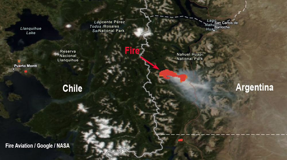
A helicopter under contract to the government of Argentina crashed Wednesday, Dec. 29 while working on a wildfire in the Patagonia region of the country according to local press reports. The two on board, a pilot and a mechanic, were killed.
The Bell 412 helicopter went down near Quillen, a lake in Neuquen province.
More than 200 personnel are assigned to the fire which has burned 9,900 acres (4,000 hectares) in or near Nahuel Huapi National Park.
The Federal Council of the Environment (Cofema) of Argentina and the Argentine Ministry of the Environment have declared an emergency throughout Argentina for the last 12 months due to drought and the risk of fires.
We send our sincere condolences to the family, friends, and co-workers of the two firefighters.
Inhaled microscopic particles from wood smoke can work their way into the bloodstream and reach the brain, putting people at risk for premature aging and various forms of dementia, depression, and even psychosis
Satellite photo, smoke from California fires at 7:01 p.m. PDT Aug 4, 2021.
The research outlined below by the University of New Mexico Health Sciences Center is further evidence of the importance of smoke management. Land managers, agency administrators, and incident management teams need to constantly consider methods of reducing smoke exposure to firefighters and the downwind population when planning, conducting, or suppressing wildfires and prescribed burns.
Woodsmoke from massive wildfires burning in California shrouded much of the West last summer, making it harder for people suffering from respiratory illnesses to breathe.
Those respiratory consequences can be dangerous — even life-threatening — but Matthew Campen, PhD, a professor in The University of New Mexico College of Pharmacy, sees another hazard hidden in the smoke.
In research published online this week in the journal Toxicological Sciences, Campen and his colleagues report that inhaled microscopic particles from woodsmoke work their way into the bloodstream and reach the brain, and may put people at risk for neurological problems ranging from premature aging and various forms of dementia to depression and even psychosis.
“These are fires that are coming through small towns and they’re burning up cars and houses,” Campen says. Microplastics and metallic particles of iron, aluminum and magnesium are lofted into the sky, sometimes traveling thousands of miles.
In the research study conducted last year at Laguna Pueblo, 41 miles west of Albuquerque and roughly 600 miles from the source of wildland fires, Campen and his team found that mice exposed to smoke-laden air for nearly three weeks under closely monitored conditions showed age-related changes in their brain tissue.
The findings highlight the hidden dangers of woodsmoke that might not be dense enough to trigger respiratory symptoms, Campen says.
As smoke rises higher in the atmosphere heavier particles fall out, he says. “It’s only these really small ultra-fine particles that travel a thousand miles to where we are. They’re more dangerous because the small particles get deeper into your lung and your lung has a harder time removing them as a result.”
When the particles burrow into lung tissue, it triggers the release of inflammatory immune molecules into the bloodstream, which carries them into the brain, where they start to degrade the blood-brain barrier, Campen says. That causes the brain’s own immune protection to kick in.
“It looks like there’s a breakdown of the blood-brain barrier that’s mild, but it still triggers a response from the protective cells in the brain — astrocytes and microglia — to sheathe it off and protect the rest of the brain from the factors in the blood,” he says.
“Normally the microglia are supposed to be doing other things, like helping with learning and memory,” Campen adds. The researchers found neurons showed metabolic changes suggesting that wildfire smoke exposure may add to the burden of aging-related impairments.
The research team included colleagues from the College of Pharmacy and the UNM Departments of Neurosciences, Geography & Environmental Studies, and Earth and Planetary Sciences, as well as researchers at Arizona State University, Michigan State University and Virginia Commonwealth University.
Story provided by University of New Mexico Health Sciences Center. Original written by Michael Haederle.
Journal Reference:
David Scieszka, Russell Hunter, Jessica Begay, Marsha Bitsui, Yan Lin, Joseph Galewsky, Masako Morishita, Zachary Klaver, James Wagner, Jack R Harkema, Guy Herbert, Selita Lucas, Charlotte McVeigh, Alicia Bolt, Barry Bleske, Christopher G Canal, Ekaterina Mostovenko, Andrew K Ottens, Haiwei Gu, Matthew J Campen, Shahani Noor. Neuroinflammatory and neurometabolomic consequences from inhaled wildfire smoke-derived particulate matter in the Western United States. Toxicological Sciences, 2021; DOI: 10.1093/toxsci/kfab147
Air Tanker 861 (N803NZ) drops on the Oak Fire Dec. 27, 2021. Still image from West Metro Fire video.
Monday afternoon December 27 a fire southwest of Denver burned 152 acres and prompted evacuations.
The Oak Fire was reported around 2 p.m. southwest of Columbine, southwest of the C470 highway which was temporarily closed. West Metro Fire said it started near the C470/Kipling intersection west of the Westerly Apartments in an open space area with several trails and heavy foot traffic. The specific cause is still under investigation. The evacuations were cancelled Monday evening.
Oak Fire, on the southwest side of Denver, Dec. 27, 2021. Photo by West Metro Fire.
A single engine air tanker from CO Fire Aviation was mobilized from Fort Morgan, Colorado, flown by the company’s Chief Pilot Chris Doyle. It took off at 3:46 p.m. and 20 minutes later landed at Northern Colorado Regional Airport NCRA near Fort Collins to get a load of plain water which took about 10 minutes. It then made the 19-minute flight south to the fire where it quickly sized it up, dropped the water just before sunset, and returned to NCRA.
Flight path of Air Tanker 861 (N803NZ) while working the Oak Fire Dec. 27, 2021. FlightAware.
The fire was driven by strong winds. Buckley Air Force Base on the east side of Denver recorded 22 to 28 mph out of the south with gusts to 35 while the relative humidity was in the high 20s with the temperature in the high 30s. However it was cooler on the other side of the city at a higher elevation near the fire, judging from the ice photographed on the air tanker’s landing gear.
Ice on the landing gear of Air Tanker 861 after dropping water on the Oak Fire, Dec. 27, 2021. Photo by Chief Pilot Chris Doyle.
Firefighters always get a lot of satisfaction conducting a mobile attack, as seen in the videos below. An engine drives near the edge of the fire while one or two firefighters operate nozzles while walking, sometimes one in front of the engine and another picking up what’s left behind the truck. Or a second engine could followup, making sure all the heat near the edge is extinguished.
The #OakFire has slowed somewhat, but it’s still being driven by strong winds. There are no air resources available in the region. Neighboring fire districts are assisting on the ground. Two buildings at the Westerly Apts have been evacuated. 1/2 pic.twitter.com/XwmpxkR8cW
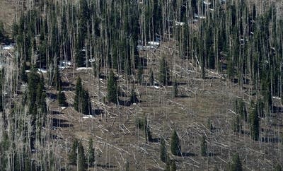
Research shows that warming shortens the time between beetle generations, supercharging beetle population growth
Pine trees killed by bark beetles. Photo by Ethan Miller.
In California’s Sierra Nevada, western pine beetle infestations amped up by global warming were found to kill 30% more ponderosa pine trees than the beetles do under drought alone. A new supercomputer modeling study hints at the grim prospect of future catastrophic tree die-offs and offers insights for mitigating the combined risk of wildfires and insect outbreaks.
“Forests represent a crucial buffer against warming climate and are often touted as an inexpensive mitigation strategy against climate change,” said Zachary Robbins, a researcher at Los Alamos National Laboratory, graduate student at North Carolina State University, and lead author of the paper on beetles and ponderosa pine tree die-offs. “Our research shows that warming shortens the time between beetle generations, supercharging beetle population growth. That can then spur catastrophic mortality in forest systems during drought in the Sierra Nevada and throughout the Western United States.”
In the recently published study in Global Change Biology, Robbins and his collaborators developed a new modeling framework to assess the risk western pine beetles, or bark beetles, pose in many forest ecosystems under climate change. If the effects of compromised tree defenses (15% to 20%) and increased bark beetle populations (20%) are additive, the team determined that 35% to 40% more ponderosa pines would die from beetle attacks for each degree Celsius of warming.
“Our study is the first to attribute a level of tree mortality to the direct effect of warming on bark beetles, using a model that captures both beetle reproduction and development rates and host stress,” Robbins said. “We found that even slight increases in the number of annual generations of bark beetles due to warming can significantly increase tree mortality during drought.”
Using Los Alamos supercomputers, the team modeled bark beetle dynamics and tree die-off during the extreme drought of 2012-2015 and earlier periods. Then they investigated those results using field observations of maximum and minimum temperature, precipitation, tree density, tree mortality, and beetle flight initiation (when fully developed beetles leave their tree of origin) along with lab studies on beetle rate of development.
They found that a quicker rate of producing new generations of off-spring contributed more to killer infestations than did surviving the winter in the absence of cold temperatures fatal to the beetle, yet, surprisingly, the increase in the number of generations was not very big.
“In the Sierra, we saw only about one-third more generations per year, but that really amplified mortality,” Robbins said. “It shows that a small impact in the success of these populations can have a big impact on tree mortality, where we previously thought the beetle needed one whole generation increase to substantially impact mortality.
“These findings should generally apply to many species of pine forests around the West, although the beetle species might be different,” said Chonggang Xu, coauthor of the paper. A senior scientist at Los Alamos, Xu simulates forest-vegetation dynamics in his research.
“Beetle-instigated die-off may cause forests to act as carbon sources to the atmosphere for decades,” Xu said. “Dead trees don’t absorb CO2 but release carbon to the atmosphere. This could potentially raise global forecasts of atmospheric carbon, which has not yet been explicitly considered in current-generation earth-system models.”
The research also has implications for forest management under climate change.
“A mechanistic understanding of the interactions among climate, forests, and disturbances can improve the planning of forest management actions and better predict the effects of climate change on biological systems,” Robbins said.
Older, bigger ponderosas are particularly vulnerable to beetle attacks because their size supports large infestations, Xu said, while younger, smaller trees can survive.
“A diverse forest that combines small and big trees and species diversity, as well, is more resilient,” Xu said. He pointed out that forest management to minimize wildfire risk often removes the smaller trees and preserves the larger ones, “which creates a forest of big trees. Then the beetle comes and the trees could be devastated at the same time.”
Bark beetles kill trees worldwide by chewing through bark and depositing their larvae in the inner bark. An increasing number of beetle outbreaks in the past two decades have devastated forests across the American West, including New Mexico, striking nearly 11 million acres nationwide and threatening the basic structure and ecological processes of some forests.
The beetles exploit the warming, drying climate in the West. When precipitation and temperature remain at historic levels, trees can defend themselves from infestation, but drought often sparks bark beetle outbreaks. That is because water-stressed trees suppress their photosynthesis, close their stoma, and grow more slowly, depleting their carbon storage, which may weaken their defenses.
The life-cycle of the beetle depends on temperature under the bark and in the air. Warmer temperatures reduce the number of beetles killed off by deep winter cold and accelerate and extend the breeding season. Outbreaks finally collapse when bark beetles exhaust the supply of susceptible trees, acutely cold temperatures kill off the beetles, or predators and parasites decimate bark beetle populations.
The study considered historic and contemporary temperature trends in a broad swath of the Sierra Nevada, including several national forests and Kings Canyon, Sequoia, and Yosemite National Parks.
In a new approach, the team used a model of the breeding cycles and population dynamics of bark beetles. The team incorporated this model into a tree-death and insect-attack model, which accounts for the number of bark beetles in flight, the number and size of trees available as hosts, and the drought. The models were validated against data from field observations.
Paper: “Warming increased bark beetle-induced tree mortality by 30% during an extreme drought in California,” by Zachary J. Robbins, Chonggang Xu, Brian H. Aukema, Polly C. Buotte, Rutuja Chitra-Tarak, Christopher J. Fettig, Michael L. Goulden, Devin W. Goodsman, Alexander D. Hall, Charles D. Koven, Lara M. Kueppers, Gavin D. Madakumbura, Leif A. Mortenson, James A. Powell, Robert M. Scheller, in Global Change Biology. DOI: 10.1111/gcb.15927.
Funding: University of California National Laboratory Fees Research Program at Los Alamos National Laboratory.
From Los Alamos National Laboratory. The paper, funded by taxpayers, is not open source. Copies are priced at $59.