MAFFS air tankers activated, only one DC-10 crew left

Preparing a MAFFS air tanker for deployment
Tech. Sgt. Mike Konegni, left, Airman Travis Mader, center, and Airman 1st Class Colton Shirley, with the 153rd Aircraft Maintenance Squadron, Wyoming Air National Guard, based in Cheyenne, Wyo., place orange tape on a C-130 cargo plane identified for an aerial firefighting mission, in the western portion of the United States, Sept. 8, 2011. The tape helps other aircraft identify the plane as part of the coordinated firefighting efforts. Photo by 1st Lt. Christian Venhuizen

Yesterday the National Interagency Fire Center activated two C-130 Modular Airborne Fire Fighting System-equipped (MAFFS) aircraft and support personnel from the 187th Airlift Squadron, 153rd Airlift Wing, Wyoming Air National Guard, out of Cheyenne, Wyoming. They will be based in Boise to fight fires in Nevada, Utah, and Idaho.

This was done because there are only 11 large air tankers left in the United States that are on exclusive use contracts, contrasted with the 44 we had in 2002. Aero Union has closed its doors and shut down their P3 air tankers due to inspection, safety, and contract issues, and the U. S. Forest Service is not interested in awarding exclusive use contracts for Very Large Air Tankers (VLAT) like Evergreen’s 747 or 10 Tanker Air Carrier’s DC-10s. CAL FIRE cancelled their exclusive use contract on June 30 for one of the DC-10s due to the state’s budget crisis, even though they were very happy with the effectiveness of the aircraft on fires.

Both Evergreen and 10 Tanker were only offered Call When Needed (CWN) contracts by the USFS this year for their VLATs. The proposed contracts did not even have a minimum number of days that they would be used on each activation, such as the 5 days that are stipulated in CAL FIRE’s current DC-10 CWN contract. Evergreen told the agency that they could not maintain their 747 in response-ready condition, with crews, without any guaranteed income. 10 Tanker reluctantly signed the CWN contract.

Within the last few weeks the USFS temporarily brought on six CWN air tankers — three Convair 580s and three CL-215 scooper aircraft.

Two DC-10 air tankers
Two DC-10 air tankers. Photo: 10 Tanker Air Carrier

10 Tanker has two DC-10 air tankers, but at this time they only have one DC-10 air tanker crew, so they can only operate one aircraft at a time. When mandatory days off are required, they have to shut the aircraft down rather than bring in a relief crew. With no guaranteed contract, they can barely keep one crew  available for CWN use.

One of the stated reasons for the USFS’s reluctance to use the VLATs is cost. But the MAFFS, with their large support crews, are not inexpensive. And the issue of using government air tankers instead of privately owned aircraft can’t be easily swept under the carpet.

Since dozens of air tankers were permanently grounded after two very old military surplus air tankers fell apart in mid-air in 2002, three studies have been commissioned to develop recommendations on how to reconstitute the large air tanker fleet. The last one was due in January, 2011, but it may not see the light of day until next year. But in the 9 years following those tragedies, nothing meaningful has been accomplished, and we’re down from 44 to 11 large air tankers. And no one has been fired.

One of the DC-10’s, the only one with a crew available, has been hired by the state of Texas for their current fire bust. At 12:40 p.m. MT they were reloading the aircraft with retardant for the third time today.

Map and update on the Riley Road fire in Texas

Riley Road fire map, 0530 CT 9-9-2011
Click to enlarge. Map of the Riley Road fire, 5:30 a.m. CT, 9-9-2011, showing the fire perimeter and heat detected by satellites.

As the spread of the devastating Bastrop fire slows and firefighters can envision containment, another fire in Texas, the Riley Road fire, is becoming increasingly active and is also destroying homes. The fire started Monday, 11 miles southwest of Montgomery, Texas and has burned approximately 58 homes, according to Texas Forest Service spokeswoman Carmen Apple. It has blackened 21,619 acres and is 60% contained.

Thursday night and early Friday morning the fire was very active on the northeast side between roads 1774 and 1486, moving much closer to the 1486 road where evacuations were ordered, including the Clear Creek Forest subdivision.

The above map shows the perimeter of the Riley Road fire and heat detected by satellites. WeatherUnderground has a zoomable map, making it possible to zoom in and see street names, but the perimeter as of 1:00 p.m. CT Sept. 9 does not show the latest spread of the fire on the northeast side where it approached Road 1486.

A Type 1 Incident Management Team, California Interagency Incident Management Team 4, with Incident Commander Rocky Opliger, arrived on Thursday. The Type 3 SanJac IMTeam has been there since Tuesday, Sept. 6.

The DC-10 Very Large Air Tanker, which carries 11,600 gallons of fire retardant, arrived at Austin, Tuesday night but it was not used on Wednesday or Thursday because the crew had to take two mandatory days off. During that time, a portable retardant plant was assembled so that the aircraft can reload at the Austin-Bergstrom International Airport. The plans are for the DC-10 to begin working on the fires Friday.

Bastrop fire in Texas: updated maps, 1,386 homes destroyed

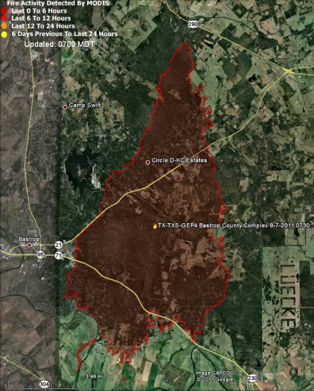
Map of Bastrop fire 9-8-2011
Map of Bastrop fire 9-7-2011. Google Earth
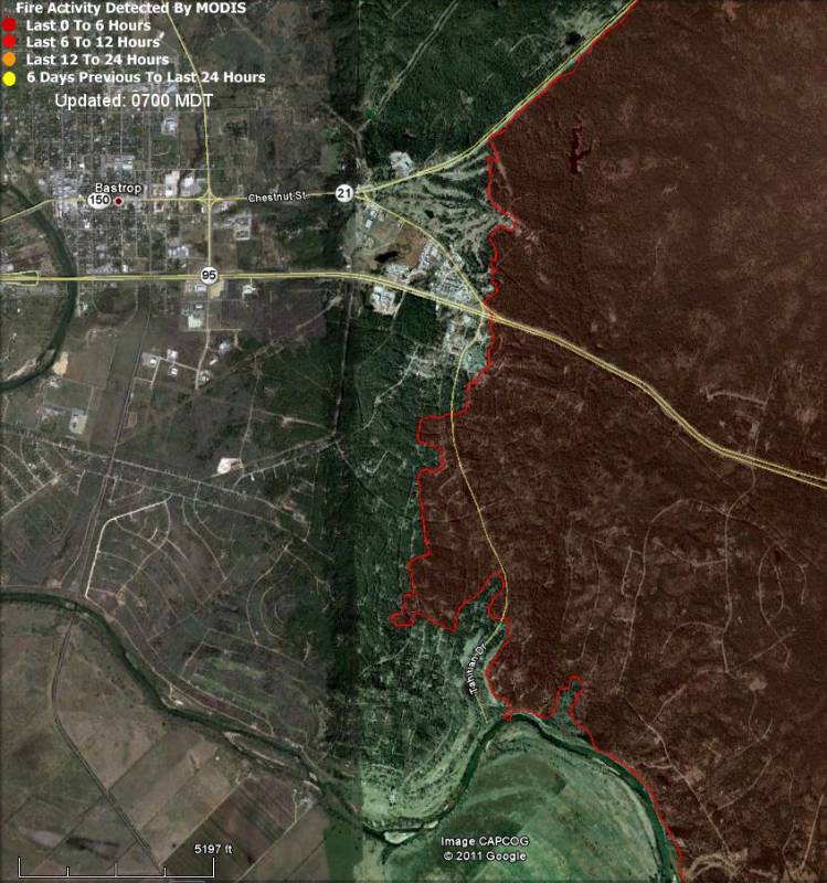
Map of Bastrop fire zoomed in on the area east of Bastrop, 9-8-2011
Click to enlarge. Map of Bastrop fire, zoomed in on the area east of Bastrop, 9-7-2011. Google Earth

Today we have updated maps of the Bastrop fire in Texas showing the actual perimeter that has been mapped by firefighters. The perimeter was created at 7:30 a.m. on September 7, 2011. If a newer version becomes available later today we will replace the maps above.

The Texas Forest Service provided this information about the fire:

BASTROP COUNTY COMPLEX, Bastrop County. 34,068 acres, 30 percent contained. Heavy airtankers, scoopers, helicopters, and SEATs assisted on this fire that started in the Lost Pines area just northeast of Bastrop. Most of the forward progress of the fire has stopped, but significant intense burning continues in the interior. An assessment team has confirmed 1,386 homes have been destroyed. Two civilians were found dead Tuesday as search crews went through the charred subdivisions. A Southern Area Type I Incident Management Team is assisting in managing the fire. A FEMA Management Assistance Grant was received.

On Wednesday a search team, Texas Task Force 1, began scouring the sites of the burned homes for additional victims. The team of 100 people has 12 dogs that are trained to find human remains.

Bastrop County has posted a list of “destroyed structures” in Bastrop and Paige. They emphasize that it is not a comprehensive list.

The weather continues to be much less extreme than the conditions caused by the tropical storm winds that pushed dozens of fires out of control over the weekend. On Thursday and Friday the temperature will be in the low 90s, with winds at 5-10 mph, but the relative humidity will be in the low teens. This is considered moderate wildfire burning conditions, but it has enabled firefighters to begin to control the Bastrop and other fires in Texas.

If you need a more detailed map, check out the ESRI web site.

Learning to live with fire

Australia fire
An engine crew attacks a fire in Australia, Feburary, 2009.

The Australian publication The Age has a very interesting article about how our culture affects our understanding of wildfire and our ability co-exist with it in a fire-prone environment. The author, John Schauble, is the Captain of the Sassafrass / Ferny Creek (volunteer) Fire Brigade, which is located on the ridge which runs through the center of the Dandenong Ranges National Park, 25 miles east of Melbourne, Victoria.

Here is an excerpt:

…In his recent book Deep Survival: Who Lives, Who Dies and Why, American author Laurence Gonzales uses the simple example of crossing the road. People can’t naturally cross a busy street without being taught. That starts as children. ”Our culture places such great importance on that type of learning that by the time you grow up you don’t even think about crossing the street,” Gonzales notes.

Other cultures have other priorities, such as fishing skills, dealing with predatory animals or celestial navigation. In Australia, where settlement clings to the coast, we put a premium on teaching our children to swim that is absent elsewhere.

Strangely, given our fire history, the same culture places little or no importance on knowing the place of fire in the landscape. As a result, very few people have even a rudimentary understanding of bushfire.

This helps explain why people don’t automatically take safe actions in response to a fire. It helps explain why there is agitation for simplistic solutions that simply won’t work. It points to why many of the solutions proposed, such as mandatory evacuation, fire refuges and large fire-bombing aircraft, are not new.

Instead, communal beliefs about fire are often shaped by myth and misunderstanding. When tragedies such as 1939’s Black Friday, 1983’s Ash Wednesday or those of February 7 last year occur, we go through the process of relearning. Yet it seems few of the lessons are enduring.

Social, environmental and economic changes mean the impact of fire will most likely grow in coming years, probably faster than Victorians will grow to intuitively understand fire. In the meantime, the rest of us must play catch-up.

This means that when people choose to live in areas where there is a fire risk, they should understand and accept the risk…

Thanks go out to WOL

Report: fuel treatments were effective at the Wallow fire

A report has recently been released that highlights several examples during the Wallow fire when fuel treatments, modifying the vegetation near populated areas, were effective in reducing the intensity of the fire, making it possible for firefighters to remain in the area and prevent structures from burning. The fire burned in eastern Arizona in May and June, 2011. It burned 522,900 acres and 32 homes, becoming the largest fire in the history of the state.

Here is an excerpt from the report:

Fuel Treatment Units Slow the Wallow Fire– Allow Firefighters to Safely Attack

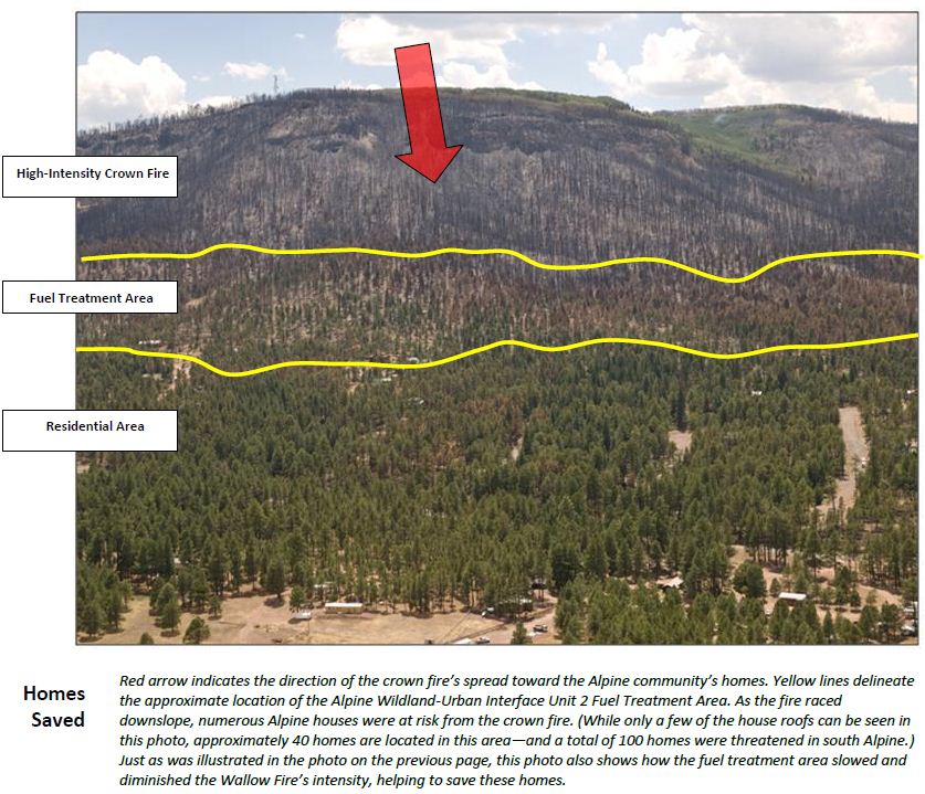
As the main fire enters the ½ mile-wide White Mountain Stewardship Fuel Treatment units located above Alpine, the blaze drops from up in the tree crowns down to the surface level. The fire’s rate-of-spread dramatically slows. Thanks to the influence of these previously developed treatment units—implemented beginning in 2004—flame lengths are now low enough to allow firefighters to safely attack the fire and protect homes and property.

Engines and crews successfully extinguish the spot fires. To further protect residents’ houses, these firefighters also conduct low-intensity “firing operations” from roadways and other fuel breaks. These aggressive firefighting suppression actions continue throughout the evening—successfully halting the spread of the Wallow Fire into the community of Alpine. In fact, all of this community’s structures—but one—are saved from the fire’s attack. (Actually, this single structure burned several days later when an ember—most likely transported downwind during the June 2 crown fire run—smoldered for several days before flaring up.)

Wallow fire fuel treatment report
An image from the Wallow fire fuel treatment report. Click to enlarge.

The report was written by Pam Bostwick, Jim Menakis, and Tim Sexton, all of the U. S. Forest Service.