Trainee firefighters with the Forestry and Fire Recruitment Program. Image from LA Times video.
Brandon Smith and Royal Ramey gained firefighting experience while incarcerated at a California facility for wildland fire crews. After being released they eventually obtained jobs fighting fires with government agencies but it took them two years. When they ran into their old inmate crew while assigned to a fire they were inspired to turn what they had learned into a training program designed for people with backgrounds similar to their own.
They founded the Forestry and Fire Recruitment Program (FFRP) and have helped hundreds of men and women get jobs. The organization provides help to those formerly incarcerated in California’s Conservation Camps, but accepts participants from all experiences and backgrounds.
“We navigated a maze and we want to help others, so they don’t go through what we did,” said Mr. Smith, now FFRP’s executive director. He cites the positive impact of a recent state law allowing inmate firefighters to become eligible for firefighting jobs by having their records expunged after completing their sentences.
FFRP also provides wildfire prevention and hazard mitigation services. Since 2017, they have grown to operate four trained crews in Southern California, including Los Angeles, San Bernardino, and Ventura Counties.
Firefighter Close Calls regularly sends out news about incidents that affect firefighters. Yesterday’s message described three that were rather bizarre.
Two firefighters in North Carolina were responding to a fire in their own vehicles at 2:30 a.m. when one of them ran off the road and crashed. Both were charged with Driving While Intoxicated. They were both already scheduled to appear in court in January to face multiple unrelated counts of arson, and now will also have court appearances in January to face the DWI charges. One of them is in line to become Chief of his department in January.
A fire apparatus in North Carolina rolled over while returning from a parade.
A Paramedic holding onto a utility vehicle while riding a bicycle to an emergency call was pulled under the vehicle and killed in the Line of Duty.
Here are the details from Firefighter Close Calls:
Two North Carolina Firefighters have been charged with DWI following a crash responding to a fire. Orrum Township VFD Assistant Chief Kenneth Aaron Caulder Jr. and Fairmont RFD Deputy Chief Melquan Williams have been charged with DWI and had their driver’s licenses revoked for 30 days following a crash on Saturday, Williams was to become chief of the department in January.
Reports are that the two men were responding to a structure fire when the crash occurred. Williams was following Caulder’s vehicle. Both men were driving their personal vehicles.
Caulder crashed his Jeep on N.C. 41 around 0231 hours when the vehicle crossed the centerline, “ran off the road to the right and struck a ditch.” He refused to take a breathalyzer test.
Caulder and his female passenger, who were not wearing seat belts, were ejected. Both were transported by Robeson County EMS to UNC Health Southeastern for treatment of minor injuries. Cops said Williams had a strong odor of alcohol and later blew a .14.
In July 2018, Caulder and Williams were among 10 other Firefighters with Fairmont Rural and Orrum Township VFD’s charged with arson. Charges came after an investigation by the Robeson County Sheriff’s Office; State Bureau of Investigation; Federal Bureau of Alcohol, Tobacco, Firearms and Explosives; and the N.C. Forest Service.
Caulder was charged with six counts of felony arson, burning a church, uninhabited house, store, two counts of felony setting fire to grass, brush, woods, and seven counts of felony conspiracy. He will appear in court for arson charges on Jan. 14 and on Jan. 20for the DWI charge.
Williams lost his job as a Maxton police officer in 2018 following the arson investigation, of which received charges of one count each of felony arson, burning a church, uninhabited house, store, and felony conspiracy. He will appear in court Jan. 7 for arson charges and Jan. 20 for DWI.
==RESPONDING FIRE APPARATUS ROLLS IN PA AND IN NORTH CAROLINA
==PENNSYLVANIA
Four Chester County (near Philly) Firefighters were injured after the fire apparatus they were in was involved in a crash, causing it to overturn. On Friday afternoon, Dec. 3, Sadsburyville Fire Co. was dispatched to Sadsbury Township for a report of an electrical fire inside a house. The engine was traveling south on Old Wilmington Road in the direction of the initial incident. The fire engine then became involved in a rollover crash.
Fortunately the 4 Firefighters inside the fire truck were wearing seat belts. The Firefighters were able to self-extricate from the vehicle and were tended to by EMS responders on the scene. All injuries were minor.
==NORTH CAROLINA:
A Hubert VFD fire apparatus returning from a parade rolled over this morning. The Captain was reportedly having chest pains just prior to the incident. KTIYP’s.
==LITTLE ROCK PARAMEDIC LODD UPDATE
A Paramedic was holding onto the roll cage of a utility vehicle while riding a bicycle to an emergency call at the Little Rock Marathon on Nov. 21 when he was pulled under the vehicle and killed in the Line of Duty.
EMS Major Dean Douglas, 50, died in the Line of Duty last Friday at the University of Arkansas for Medical Sciences from severe head trauma caused by the crash.
About 1000 hours Nov. 21, two hours after the marathon started, Douglas and two other EMS members were dispatched to a call about a marathon runner needing medical assistance. Neothe EMS members in the UV were injured.
Major Douglas’ last act of heroism was donating his organs. A father of three, owned D2 Comics and More in Jacksonville, and was a volunteer Fire Captain with the Gravel Ridge Fire Department. He also was a Navy veteran who served in Operation Desert Storm.
Take Care. Be Careful. Pass It On.
BillyG
The Secret List 12/4/2021-1545 Hours
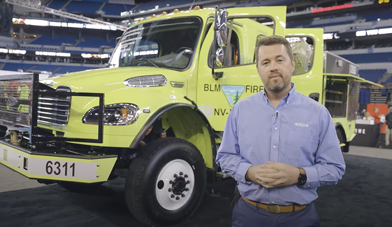
Pierce Manufacturing has produced a video walk around of the Bureau of Land Management’s Freightliner wildland fire Type 3 heavy fire engine, escorted by Scott Kiernan, Chief Engineer at Pierce. The apparatus is designed to carry 3,000 pounds of equipment, 800 gallons of water, and 20 gallons of foam. The rear-mounted pump is driven with a separate engine.
New BLM Engine 6311, rear of cabin. Image from Pierce video.
Due to previous fatal rollovers, the BLM wanted a safe cab. The new engine is equipped with side roll protection and public service vehicle (PSV) seats. The roll cage maintains the cab structure in the event of a rollover crash. The vertical framework structure integrated into the body and subframe can withstand a 60,000 pound static load and will not deflect below the cab height in a crash.
Example of data from satellite-based location reports, Caldor Fire, September, 2021. Dingell Act Resource Tracking (DART) team image.
In September during the late stages of the Caldor Fire which burned about a quarter-million acres near South Lake Tahoe, California an interagency team conducted a pilot deployment of location tracking and common operating picture technologies. They tested three different systems that track hardware mounted on vehicles or carried by personnel. They also evaluated real time video shot by an aircraft and made instantly available to firefighters. Other pilot projects were conducted on the Tussock Fire in Arizona in May, and the Tamarack Fire which burned from California into Nevada in July.
These two categories of information comprise what we have called the Holy Grail of Wildland Firefighter Safety — knowing the real time location of the fire and firefighters. Dozens, if not more, firefighters have been killed when this information was not known. If you think about firefighter entrapments, many could have been prevented if, for example, the Crew Boss, Division Supervisor, or Safety Officer had access to this real time situational awareness information.
Tracking fire resources
Legislation passed March 12, 2019 addressed this issue. The John D. Dingell, Jr. Conservation, Management, and Recreation Act mandated that the *five federal land management agencies “jointly develop and operate a tracking system to remotely locate the positions of fire resources for use by wildland firefighters, including, at a minimum, any fire resources assigned to Federal type 1 wildland fire incident management teams”, due by March 12, 2021.
Tracker (white box) installed on BLM engine. BLM photo.
The Bureau of Land Management has installed hardware for Location Based Services (LBS) which are now operational on more than 700 wildland fire engines, crew transports, and support vehicles. Vehicle position and utilization data are visually displayed via a web-based portal or mobile device application.
“The LBS system has been implemented program wide and used successfully during the 2021 fire year by wildland fire managers and dispatchers to view nearly real time locations of BLM firefighting vehicles,” said Jessica Gardetto, BLM Chief of External Affairs. “The system and its viewer are gaining widespread use, especially as LBS data is visible in the Enterprise Geospatial Portal (EGP). EGP is widely used in dispatch centers and by fire managers to display wildland fire information viewable by multiple agencies and accessible by all cooperators.”
The US Forest Service is thinking about it.
“Based on the results of these pilot programs, strategies are being prepared for the adoption of tracking units for all agency-owned or operated incident vehicles and interagency hotshot crews,” said Stanton Florea, Fire Communications Specialist for the Forest Service.
We asked the Forest Service if they had installed any tracking units, and if so how many, and did not receive an answer by publication.
(UPDATE December 10, 2021. Wildfire Today received additional information from Mr. Florea today. He said the Angeles National Forest in Southern California has installed location trackers on engines and other fire vehicles. He explained that, “The USDA Forest Service and its Dept. of Interior partners are working on developing an investment proposal to support the acquisition and operation of a system.”)
Real time mapping or video
A requirement of the Dingell Act was that was due by September 12, 2019 was to “…develop consistent protocols and plans for the use on wildland fires of unmanned aircraft system technologies, including for the development of real-time maps of the location of wildland fires.”
We asked Ms. Gardetto about the status of real time mapping. She said the agency has developed plans and protocols for real-time mapping processes, “but they remain constrained by connectivity in remote locations. Real-time mapping capacity is dependent on the availability of technology and subsequent deliverables, though again, real-time mapping services by UAS are not generally requested by incident management teams or fire management personnel.”
If the service does not exist, it is unlikely that any firefighting resources are going to request it during an incident.
We asked the US Forest Service about the status of providing real time mapping to firefighters on the ground and did not receive an answer by the time of publication.
(UPDATE December 10, 2021. Wildfire Today received additional information from Mr. Florea today. He mentioned, as we described below, the pilot deployment on the Caldor Fire of a military aircraft with Distributed Real Time Infrared (DRTI) live video. There was no indication of widespread or routine deployment of real time video.)
Findings from the pilot deployment on the Caldor Fire
The pilot deployment on the Caldor Fire of common operating picture technologies showed that the technology exists, and it is a matter of selecting the hardware and support systems that can make the information available to firefighters.
It is impressive from a technological perspective. The three tracking systems they worked with were:
Everywhere Hub devices: Garmin inReach® Mini and inReach® SE+ send the data to the Enterprise Geospatial Portal (EGP) for viewing in a variety of tracking systems.
Team Awareness Kit (TAK). A smartphone app that uses a phone’s GPS to track its user’s location, and displays the locations of other TAK app users.
Vehicle trackers on BLM fire apparatus. Uses both cellular and satellite connections to send the vehicle’s location to the EGP.
On the Caldor Fire a military aircraft with Distributed Real Time Infrared (DRTI) program also was deployed and provided fire managers with the only source of live aerial video. DRTI is a collaboration between the U.S. Forest Service and the Air National Guard. This program provides real-time intelligence to fire managers using Air National Guard RC-26 aircraft equipped with high resolution thermal infrared and visible light cameras. These aircraft downlink a live video stream of wildland fires to National Guard soldiers on the ground, who can receive the video on a handheld military ROVER radio and display it on a tablet or television screen for fire managers to view.
DART focused on issuing Everywhere Hub devices to specific divisions on the east zone of the Caldor Fire in an attempt to saturate areas of fireline, ensuring that as many resources as possible in the areas were tracked. A total of 185,382 position reports were received during the 14-day DART deployment on the Caldor Fire.
Elon Musk’s Starlink system
Starlink satellite dish providing internet service on the Caldor Fire. BLM photo.
The new technologies used included Starlink, a system developed by an Elon Musk company to eventually provide internet connectivity virtually anywhere in the world via a 23-inch satellite dish. (There is a newer version that is smaller and lighter, 12 by 19 inches weighing in at only 9.2 pounds.) The dish was tested by DART as a means to provide high-speed, low-latency internet service to remote areas of the Caldor Fire. They also used a Jagwire Server, which serves the aircraft’s live video stream to firefighters over cellular internet, and the Android Team Awareness Kit (ATAK) with an Unmanned Aerial System (UAS) Tool plugin. Speeds of 100-200 mbps down and 30 mbps up were found at the Starlink Dish.
*Five federal land management agencies involved in wildland fire are National Park Service, Fish and Wildlife Service, Bureau of Indian Affairs, Bureau of Land Management, and Forest Service.
Shows climate change has driven a significant increase in Australia’s forest fire activity over the last three decades
Climate change factors, wildfire weather and activity. From the research.
From CSIRO
A lengthening of the fire season towards Autumn and Winter was identified, along with an increase in fire activity in cooler and warmer regions including alpine forests in Tasmania and tropical rainforests in Queensland.
The research published in Nature Communications is the first of its kind and combines analysis of previous forest fire sites with eight drivers of fire activity including climate, fuel accumulation, ignition, and management (prescribed burning).
Thirty-two years of satellite data and 90 years of ground-based datasets from climate and weather observations, and simulated fuel loads for Australian forests, formed the basis of the research, which allowed researchers to identify climate change driven increases versus natural variability.
CSIRO scientist, Dr. Pep Canadell, said the research was one of the most extensive studies of its kind performed to date, and was important for understanding how continued changes to the climate might impact future fire activity.
“While all eight drivers of fire-activity played varying roles in influencing forest fires, climate was the overwhelming factor driving fire-activity,” Dr Canadell said.
“The results also suggest the frequency of forest megafires are likely to continue under future projected climate change.”
Over the last 90 years, three of the four mega fire years occurred after the year 2000. A mega fire year is defined as the cumulative burned area of forest over one year of more than 1 million hectares.
Australia’s mean temperature has increased by 1.4 degrees Celsius since 1910, with a rapid increase in extreme heat events, while rainfall has declined in the southern and eastern regions of the continent. Globally fire activity is decreasing, however, the extent of forest fires in Australia is increasing.
Burned area, whole of continental Australia including Tasmania, linear fit. From the research.
When comparing the first half (1988 – 2001) with the second half (2002-2018) of the record studied, the research showed that the average annual forest burned area in Australia increased 350 per cent, and 800 per cent when including 2019.
Comparing the same time period, the research showed a five-fold increase in annual average burned area in winter and a three-fold increase in Autumn, with Spring and Summer seeing a ten-fold increase.
“In Australia, fire frequency has increased rapidly in some areas and there are now regions in the southeast and south with fire intervals shorter than 20 years. This is significant because it means some types of vegetation won’t reach maturity and this could put ecosystems at risk,” Dr Canadell said.
“Understanding these trends will help to inform emergency management, health, infrastructure, natural resource management and conservation.”
Bushfire. Courtesy of CSIRO.
The research was conducted by J. G. Canadell, C. P. Meyer, G. D. Cook, et al.
The Fergus County Fire Warden, Ryan Peterson, said on December 1 that a power line was the suspected cause of the fire that destroyed grain elevators and 25 homes in Denton, Montana that day. Winds gusting up to 65 mph pushed the fire, spreading for 18 miles from Highway 80 to the east well past Denton.
The Opportunity Bank of Montana has started a donation drive to assist victims and evacuees. Checks can be made payable to the Denton Fire Relief Fund and mailed to the bank at PO Box 1047, Denton, MT 59430.
The state of Montana mobilized a County Assist Team and helicopters to aid in the suppression and recovery from the fire.
At the Coffee Creek N weather station northwest of Denton the high temperature recorded on December 1 when the fire burned through the town was 66 degrees at 1 p.m., with a minimum relative humidity of 37 percent. The maximum sustained wind speed and wind gust that day occurred at the same time — 41 mph gusting to 65.
The temperature was 30 degrees warmer than normal. According to Accuweather the average high temperature for Denton on December 1 is 36 degrees. The forecast for today, Friday December 3, is a high of 40 degrees with a 25 percent chance of snow Friday night.
Earlier this week new records were set in Montana and other western states for daily and monthly high temperatures.
7:46 p.m. MST Dec. 2, 2021
Grain elevators and 25 homes burned in Denton, Montana Wednesday December 1 as a large wildfire burned through the town, the Fergus County Sheriff’s office said.
The West Wind Fire was reported at 11:14 p.m. Tuesday Nov. 30 near Highway 80. Pushed by 24 to 40 mph winds gusting out of the west up to 60 mph hour it quickly spread east from Judith Basin County into Fergus County. On Wednesday Dec. 1 it burned into Denton, population about 300, and destroyed grain elevators, bridges, and 25 residences. The Sheriff’s Facebook page has a list of the affected homes.
West Wind Fire map Dec. 2, 2021.
The wind was too strong on Wednesday for aircraft to assist firefighters.
The town was evacuated and there were no reports of serious injuries or fatalities. The Sheriff expected to lift the evacuation order Thursday afternoon. Highway 81 west of Denton is closed due to a bridge that burned.
The fire was no longer spreading on Thursday after burning 10,644 acres.
There has been record setting heat in Montana in recent days.
The wildfire potential in central Montana is predicted to be higher than average in December.
Do not drive into a flooded street. Do not drive into a fire.
Major brush fire ongoing in Denton, MT. Less than a half mile out of town. No immediate threat to the community at the moment. Route 81 heading towards Coffee Creek is closed as the fire has jumped the highway. #MTwxpic.twitter.com/CTEKqs8oIu