Fire detection sensors are being set up around Maui and other Hawaiian islands to allow local resources to respond faster when wildfires break out, said Governor Josh Green today.
CNN reports that Maui Mayor Richard Bissen added, “The introduction of an early detection system will give our first responders a critical advantage in protecting our community. With this new technology, detecting fires at the very early phases will save lives.”
According to MauiNow, the remote sensors are en route to Kīhei and Lahaina, and they will use a combination of thermal imaging, gas detection, and Artificial Intelligence (AI) algorithms; the wildfire sensors detect concentrations or spikes in particulates or carbon monoxide to identify wildfire ignition — in real time. The sensors transmit data by email or text notifications to pre-set contacts, and the remote units are small enough for installation on utility poles or traffic lights. They can also work in all weather conditions, according to the U.S. Department of Homeland Security.
“What’s important is we get to the scene as fast as we can, so that we can catch fire in incipient phases,” said Maui Fire Chief Brad Ventura. “Today we share one more tool that’s going to help expedite our responses to our communities.”
About 80 fire sensors are being set up around the islands; the first 20 on Maui are planned for deployment by the first week of April.
These sensors detect heat and also can track anomalies such as airborne smoke particles and gases produced by fires — and can distinguish those from other substances common in the air around Hawai’i — including volcanic ash and ocean salt.
~ Thanks and a tip of the hardhat to Rick for this.
Guess which utility company in Oregon was ordered in a jury trial to cough up another $42 million for its negligence in starting the 2020 Labor Day fires?
It’s come to feel almost like a late-night comedy routine. Financial damages now total up in the billions of dollars, as PacifiCorp and others have racked up loss after loss in court with people who lost their homes, their properties, friends and family members, and often lifetimes of memories living in scenic river canyons of western Oregon. The utility company was ordered yesterday to pay off 10 more victims of the fires 3½ years ago that were driven by east winds, high temperatures, and flames started by neglected electric equipment owned and (not) maintained by Pacific Power, which is a part of PacifiCorp, which is a part of Berkshire Hathaway Energy.
Oregon’s 2020 Labor Day fires — Oregon State Fire Marshal photo
As an Associated Press report explains, in June of last year a jury found PacifiCorp liable for negligently refusing to cut power to its 600,000 electric customers, despite repeated warnings from fire and emergency officials. The jury determined that the utility had acted negligently and willfully and should have to pay punitive and other damages — a decision that applied to a class of current and potential litigants including the owners of up to 2,500 properties.
Tuesday’s decision was the third verdict applied to a specific set of plaintiffs. Last month, a jury awarded $85 million to a different group of nine plaintiffs, and the jury that initially found PacifiCorp liable awarded about $90 million to 17 homeowners named as plaintiffs in that case.
Other PacifiCorp lawsuits over the Labor Day 2020 fires are detailed HERE and HERE and HERE and HERE and HERE and HERE and HERE and HERE. Thousands of other class members are still awaiting trials, though the sides are also expected to engage in mediation that could lead to a settlement.
The U.S. government is also threatening to sue PacifiCorp to recover nearly $1 billion in costs related to the 2020 wildfires in southern Oregon and northern California, though the company is trying to negotiate a settlement. The PacifiCorp website says the company leads in wildfire mitigation, and its system-wide, six-state plan includes in-house emergency management and meteorology and data science teams — and features the installation of over 450 weather stations, grid hardening, fire-risk modeling software, and an “enhanced” vegetation management program.
“The safety of our employees, customers, and communities remains our top priority,” declares PacifiCorp.
Meanwhile in southeast Idaho, renewable energy developer NorthRenew Energy has sold its 300-MW-plus Arco Wind and Solar project in southeast Idaho to PacifiCorp. This is NorthRenew’s ninth project sale since the company’s inception in 2017.
The “most important law in the creation of eastern national forests” was established on this day 113 years ago.
The Weeks Act, signed into law by President William Howard Taft on March 1, 1911, allowed the federal government to purchase private land to protect the headwaters of rivers and watersheds in the eastern United States. The act nationalized the U.S. Forest Service, as neither federal nor state governments owned substantial forested lands east of the Mississippi River before the act’s passage.
According to the Forest History Society, in just 10 years Congress had rejected more than 40 bills calling for the establishment of eastern national forests.
Senators and congressmen opposed these measures for various reasons; some western representatives (and conservation groups) who supported national forests in principle resented the possible loss of funding to their eastern counterparts. Many fiscal conservatives agreed with House Speaker Joe Cannon when he declared “not one cent for scenery.”
Leadership on the issue came from a surprise source. Congressman John Weeks, a Republican from Massachusetts, was a former naval officer and a successful banker. Weeks was elected to the House in 1905, and two years later he was appointed to the House Committee on Agriculture by Speaker Cannon.
Congressman John Wingate Weeks
At first Weeks didn’t understand why — he had few farmers in his district, and he had little interest in agricultural issues in Congress. He was concerned, though, about the damage logging had caused in the White Mountains, near where he had grown up and where he now summered with his family. Speaker Cannon told Weeks that if he, as a businessman, could put together a forestry bill that he supported, then Cannon would get it considered in the House. The man who had once declared “not one cent for scenery” had changed his mind.
The Weeks Act not only paved the way for the National Forest System, but also established the nation’s first interagency wildland firefighting effort, an effort that continued and worsened the settler colonial practice of fire suppression through bans of cultural fire usage.
There were multiple reasons for prioritizing USFS fire control for the new forests, according to a system article published on the act’s centennial. A 1902 report described the biggest threats to Appalachian forests as being fires and logging. In 1910, a series of catastrophic wildfires now known as the “Big Blowup” devastated Idaho and Montana, killing more than 100 firefighters and destroying several towns. Forest reserve advocates used these and other fire events to convince Congress to establish an agency that would primarily focus on wildfire suppression.
“Fire lookout towers and trails were built and ‘forest guards’ were hired at a salary of $50 a month,” the USFS article said. “Because the Weeks Act provided matching federal funding for state wildfire management spending, state divisions of forestry also upgraded their fire control organizations.”
What wildland firefighters now affirm as an uninformed suppression effort was worsened through fear-based short-sighted decisionmaking, along with xenophobic attitudes toward the people who had long lived on the land.
The Karuk Tribe in California views the passage of the Weeks Act and the increasing catastrophic fires across the country as having a direct connection.
“The passage of the Weeks Act in 1911 following the Big Burn of 1910 made cultural uses of fire essentially illegal, and for the many decades following, less and less burning occurred while more and more vegetation grew,” the tribe’s website said. “Over a century of policies of fire suppression has created the conditions for the catastrophic, high-intensity wildfires we are seeing today. Warming temperatures and summer droughts further exacerbate these conditions.”
The USFS wildland firefighting system now largely understands the benefit of managed fire and makes an effort to include tribes in its decisionmaking. There is more work to be done, however, as climate change further exacerbates the cracks in the system that firefighters and managers are trying to mend. For better or for worse, it all started with the Weeks Act.
Aerial images from Hutchinson County, Texas shot with a drone yesterday show the aftermath of a huge fire adjacent to a 7-mile swath of land that was prescription burned a few months ago near Borger, a Panhandle town of about 12,000 in north Texas.
Borger, Texas, on Wednesday. Photo by City of Borger / Hutchinson County Office of Emergency Management.15:08 CST 02/29
Northeast of there, the Smokehouse Creek Fire, the largest of at least five other active fires in the Panhandle, has burned over 1 million acres, leaving charred homes and buildings behind. The fire’s doubled in size since 03:00 CST on 02/28.
The drone images in a CNN report feature a 7-mile prescribed burn that was conducted a few months ago.
Officials with Borger’s Office of Emergency Management said the prescribed burn prevented a fire flank from spreading into the southern parts of the town, including the Meadowlark, Country Club, and Bunavista areas.
“As much damage as we have, our proactive efforts did prevent even more,” Hutchinson County officials said. — [Panhandle fires photo gallery]
The fires in Texas and Oklahoma have burned so much land that the blackened ground is visible from space. Satellite imagery captured burn scars stretching from the Texas Panhandle into western Oklahoma Wednesday afternoon.
Satellite shots show burn scars in the Texas Panhandle in the wake of devastating fires. CIRA/RAMMB images.
Burn scars are often a combination of burned vegetation, debris, and a scorched layer of soil. In the satellite image above, the burn scar appears as charcoal gray and black against the tan unburned ground around it.
~ Thanks and a tip of the hardhat to Chris and Alison.
WEDNESDAY EVENING UPDATE FROM CNN: Fires burning in the Texas Panhandle and in Oklahoma have evacuated towns and killed at least one person. The 850,000-acre Smokehouse Creek Fire started Monday and is now 3 percent contained; it’s the second-largest fire in the state’s history.
Wildfires in the Texas panhandle are burning rapidly across drought-parched miles of grassy fuels, threatening towns and evacuating residents. How did the state’s second-largest fire ever burn to well over a half-million acres in just a couple days?
On the night of February 27 strong winds pushed the Smokehouse Creek Fire across several roads in the Texas Panhandle. Texas A&M Forest Service photo.
High winds and drought, mostly, according to the National Weather Service’s Amarillo office. The East Amarillo Complex in 2006 burned over 900,000 acres — in the same general location. Samuel Scoleri, a forecaster at the NWS, told Isabella O’Malley with the Associated Press that dry winters are fairly standard in the Panhandle, but temperatures on Tuesday were in the 70s rather than the usual 50s and 60s for late February. “It kind of just feels out of the ordinary,” he said, “considering at the top of the month we had places get almost half a foot of snow down south.”
Politico reported that the largest of the fires, the Smokehouse Creek Fire, closed highways and a nuclear weapons site. The Pantex facility for assembling and disassembling the country’s nuclear arsenal shut down operations Tuesday night as fires burned near its facility 30 miles east of Amarillo. Pantex issued a statement online saying it had paused operations until further notice.
Smokehouse Creek Fire 02/27/2024
The Smokehouse Creek Fire near Stinnett was first reported Monday evening; USA Today said by Wednesday the fire had grown to about 500,000 acres — twice its estimated size on Tuesday evening — and was still at zero containment, according to the Texas A&M Forest Service.
ABC7 News reported that Texas Governor Greg Abbott announced a disaster declaration yesterday for 60 counties, including all 26 counties in the Panhandle.
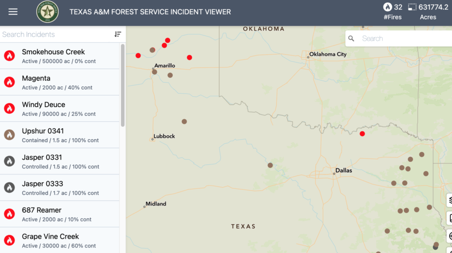
Texas fire map
Officials are warning those who evacuated from the town of Fritch ahead of the Smokehouse Creek Fire that destruction there is considerable. “People who live in the Fritch area are probably not going to be prepared for what they’re going to see as they pull into town,” said Deidra Thomas with the Hutchinson County Emergency Management. “There are still homes that are on fire.” The main road into the south side of Fritch is still closed. “Right now, we can’t let you in,” she said. “It is not safe to do that.”
Wildfires northeast of Amarillo in the panhandle, 06:00 EST 02/28/24 28, 2024. The largest, the Smokehouse Creek Fire, is estimated at 500,000 acres.
The governor also directed the Texas Division of Emergency Management (TDEM) to activate emergency response resources for local firefighters battling the multiple fires. “I issued a disaster declaration today to ensure resources are deployed to areas in the Texas Panhandle,” said Abbott.
Strong winds, unseasonably high temperatures, and dry grass are fueling the fires. Hot and dry and windy conditions should continue in the region in the coming days.
FIRE DANGER: Texas A&M Forest Service
Dry conditions and above-normal temperatures resulted in parts of the state facing increased fire risks, according to the Texas A&M Forest Service. Several wildfires across the Panhandle started on Monday, and the Forest Service responded to 13 new requests for assistance on wildfires burning nearly 80,000 acres across the state. CNN reported that the Smokehouse Creek Fire burned 500,000 acres in under 48 hours and forced evacuations in multiple counties. That’s more acres than the combined total of all Texas fires for 2023. Numerous homes on the perimeter of the town of Canadian were burned, Hemphill County Judge Lisa Johnson told The Canadian Record.
The Associated Press reported that fires tore through sparsely populated counties on the High Plains dotted with oil rigs and cattle ranches. By this morning wind speeds had decreased and the humidity has risen. Northwest winds are predicted throughout the morning, shifting to the east around 6 mph late in the afternoon, then to the south late in the day. Forecasters warned there’s also potential for wildfire fire activity in East Texas, the Rolling Plains, and western Cross Timbers, and fire conditions will likely pick up and increase again by the weekend.
There are currently 63 counties with burn bans in place.
~ Thanks and a tip of the hard hat to Jim, Brian, and Patrick.
The federal government plans to sue PacifiCorp for nearly $1 billion in costs related to the 2020 wildfires in southern Oregon and northern California; the company is trying to negotiate a settlement.
According to an Associated Press report, the pending lawsuits were disclosed in an annual report from the parent company, Berkshire Hathaway Energy, on Monday. The utility company has already agreed to pay hundreds of millions in lawsuits related to the 2020 fires.
Berkshire Hathaway Energy said the Department of Justice is seeking $625 million in suppression and cleanup costs that followed the Archie Creek and Susan Creek fires. Oregon’s Justice Department said it also wants $109 million in damages for those fires, and the Forest Service has asked PacifiCorp for $356 million for suppression and damages over the Slater Fire — which started in California and then burned over the state line into Oregon.
The company estimates that its utilities face at least $8 billion in claims from all the wildfire lawsuits already filed, but damages could be doubled or even tripled in some of those cases.
Other PacifiCorp lawsuits over the Labor Day 2020 fires are detailed HERE and HERE and HERE and HERE and HERE and HERE and HERE.
The PacifiCorp website says the company leads in wildfire mitigation, and its system-wide, six-state plan includes in-house emergency management and meteorology and data science teams — and features the installation of over 450 weather stations, grid hardening, fire-risk modeling software, and an “enhanced” vegetation management program.
“The safety of our employees, customers, and communities remains our top priority,” declares PacifiCorp.
Meanwhile in southeast Idaho, renewable energy developer NorthRenew Energy has sold its 300-MW-plus Arco Wind and Solar project in southeast Idaho to PacifiCorp. This is NorthRenew’s ninth project sale since the company’s inception in 2017.
NorthRenew energy projects
Renewables Now reported last week that the project in Bingham and Bonneville counties is designed with a storage capacity of more than 300 MW of wind and solar power, but could be expanded by as much as 800 MW of solar energy in the future. The project acquisition extends PacifiCorp’s diverse mix of generating resources across its system spanning the western states of Oregon, Washington, California, Utah, Idaho, and Wyoming.


 According to the