October wildfire potential to remain high in Montana, Northern California, and the Carolinas

New four-month forecast is available

3:49 p.m. MDT Oct. 5, 2021

wildland fire potential October 2021
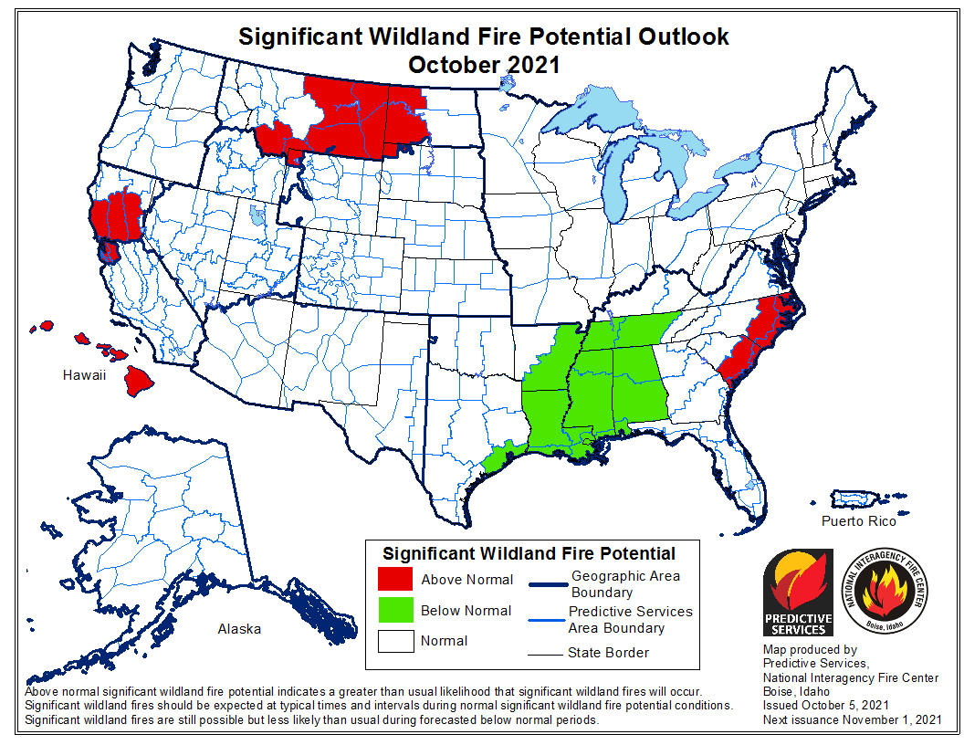
An updated forecast for wildland fire potential for the next four months was issued October 5 by the National Interagency Fire Center. If their predictions are correct:

  • October: The potential in Southern California will be below average through January; Northern California and parts of Idaho and Montana will be above average in October, while the Mid-South will be below average.
  • November: Northern California will remain above average along with Central Texas, Central Oklahoma and parts of the East Coast;
  • December: Central Texas, Central Oklahoma and parts of the East Coast will be above average.
  • January: Central Texas, Central Oklahoma, most of Florida, and the southern portions of Alabama and Georgia will be above normal.

The data from NIFC shown here represents the cumulative forecasts of the ten Geographic Area Predictive Services Units and the National Predictive Services Unit.

Below:

  • An excerpt from the NIFC narrative report for the next several months;
  • Additional NIFC monthly graphical outlooks;
  • NOAA’s three-month temperature and precipitation forecasts;
  • Drought Monitor;
  • Keetch-Byram Drought Index.

“Climate outlooks indicate warmer than normal conditions are likely for much of CONUS into winter with temperatures likely closer to normal in the Pacific Northwest, Northern Rockies, and into the western Great Lakes. Above normal precipitation is likely across the Pacific Northwest into the Northern Rockies through fall with below normal precipitation likely for the southern half of the West and the southern and central Plains. The Southeast is forecast to have below normal precipitation through fall, but portions of the region could be susceptible to heavy rainfall events.

“Above normal significant fire potential is forecast to continue into October for southwest Montana and eastern Montana into western North Dakota as these areas have missed the heavier precipitation in September. Western slopes of the northern Sierra through the Sacramento Valley to the Coast Ranges from the Bay Area to Ukiah, CA are forecast to have above normal potential through November, with leeside locations in Hawaii likely to have above normal significant fire potential into November as well. Portions of Oklahoma, Texas, and the eastern Carolinas into Florida are likely to have above normal significant fire potential this fall into winter, with portions of the Mid-Atlantic forecast to have above normal potential in November and December. All other areas are likely to have near normal significant fire potential or are out of fire season through January.”


wildland fire potential November 2021

wildland fire potential December 2021

wildland fire potential January 2021

90-day outlook, temperature and precip
Continue reading “October wildfire potential to remain high in Montana, Northern California, and the Carolinas”

KNP Complex of fires crosses Generals Highway east of Wilsonia, California

Burns most of the Redwood Mountain Grove, the largest grove of giant sequoia trees on earth.

 1:30 p.m. PDT Oct. 5, 2021

KNP Complex map north side Wilsonia
KNP Complex map, north side. The red line was the perimeter at 7:30 p.m. Oct. 4, 2021. The green areas are the APPROXIMATE locations of groves of giant sequoias.

On Monday the KNP Complex of fires in Sequoia National Park, pushed by 55 mph winds, crossed Generals Highway about a mile east of Wilsonia. The extreme fire behavior forced firefighters to temporarily move to safer locations. The additional growth resulted in the fire becoming well established in Redwood Creek and burning much of the Redwood Mountain Grove, which is the largest grove of giant sequoia (Sequoiadendron giganteum) trees on earth. It contains the world’s tallest giant sequoia, 312 feet (95 meters). The amount of mortality of the sequoias is unknown at this point.

At least two very large pyrocumulus convection columns of smoke were seen Monday on the north side of the fire that rose to more than 32,000 feet, indicating extreme fire behavior.

This additional growth threatens Hartland, Quail Flat, Wilsonia, and Grant Grove. Firefighters are doing what they can to provide structure protection in these locations.

KNP Complex map
KNP Complex map. The red line was the perimeter at 7:30 p.m. Oct. 4, 2021. The white line was the perimeter about 48 hours before. The green areas are the APPROXIMATE locations of groves of giant sequoias.

The KNP Complex has burned 79,382 acres. Resources assigned include 27 hand crews, 90 engines, 35 water tenders, 18 dozers, and 13 helicopters for a total of 1,566 personnel.

On the southern side of the fire Monday, firefighters worked along Mineral King Road to contain the spot fires from Sunday night. They also provided structure protection in Silver City and the Mineral King area. Helicopters were able to support ground resources with bucket drops on Monday after the smoke cleared enough to safely fly.

On Tuesday crews are working on control lines to keep the fire out of the communities near the Redwood Mountain Grove on the north side of the blaze.

KNP Complex of fires
KNP Complex of fires. Uploaded to InciWeb Oct 4, 2021.

Auburn Fire burns more than 900 acres north of Rapid City, SD

Evacuations were still in effect Tuesday morning

5:27 p.m. MDT Oct. 5, 2021

Map Auburn Fire 10-5-2021
Map produced by a multi-mission aircraft Tuesday morning, Oct. 5; 964 acres.

Tuesday morning an aircraft mapped the Auburn Fire north of Rapid City and determined it had burned 964 acres.

Firefighters have conducted one or two firing operations on Tuesday to help secure the firelines. They are being assisted by a Type 1 helicopter which is dropping water.

Another fire broke out Tuesday in Southwest South Dakota 14 miles east of Hermosa and burned 650 acres on the Pine Ridge Reservation. Three single engine air tankers helped slow the spread.


10:34 a.m. MDT Oct. 5, 2021

Auburn Fire map Rapid City South Dakota
The red dots on the map represent heat detected by satellites on the Auburn Fire as late as 2:54 a.m. MDT Oct. 5, 2021. Grass that burned and then cooled between overflights does not show up.

The Auburn Fire burned an estimated 500 to 750 acres north of Rapid City, South Dakota Monday. Overnight firefighters stopped the spread and completed a line around the blaze with the help of a tactical firing operation. Much of the fire burned through timber which will be smoking for days and will require extensive mop up.

It was reported at 1:49 p.m. Monday west of Auburn Drive between Haines and Deadwood Avenues north of Interstate 90. It started in Pennington County and spread north into Meade County.

Auburn Fire - Rapid City
Auburn Fire – photo by Rapid City FD, Oct. 4, 2021.

Evacuations ordered Monday were still in effect Tuesday morning. The areas affected theoretically could be seen on a map. However, our experience was that the map was not visible on a Chrome browser, but it did work on Firefox and Safari.

There have been no reports of any structures destroyed.

Resources on the fire Monday included one large air tanker, a large type 1 helicopter, two single engine air tankers, dozers, and federal, state, and local firefighters.

The Rapid City air tanker base at the airport was activated to reload the air tankers.

Auburn Fire - Rapid City
Auburn Fire, Oct. 4, 2021, looking north  from Mt. Rushmore Road/US 16. Photo by Pennington County Sheriffs Office.

Near critical fire weather conditions are expected through Wednesday. The forecast calls for temperatures to be in the upper 80s or lower 90s with relative humidity falling into the 7 to 20 percent range. Winds are expected to be out of the south at 10-20 mph.

The aircraft used Monday were still available Tuesday morning if needed.

Auburn Fire - Rapid City
Dozer on the Auburn Fire, Oct. 4, 2021. Photo courtesy of Great Plains Fire Information.
Auburn Fire - Rapid City
Auburn Fire – photo by Rapid City FD, Oct. 4, 2021.
Auburn Fire - Rapid City
Auburn Fire – photo by Rapid City FD, Tuesday morning Oct. 5, 2021.

Large firing operations underway on KNP Complex of fires

Sequoia National Park in California

4:13 p.m. PDT October 4, 2021

The firing operation on the north side of the KNP Complex along the Generals Highway/180 southeast of Wilsonia is moving along rapidly. It appears to have begun on Saturday, and by the time of the mapping flight Sunday night had spread half a mile to a mile south of the highway. It is now moving through the Redwood Mountain Grove, which is the largest grove of giant sequoia (Sequoiadendron giganteum) trees on earth. It contains the world’s tallest giant sequoia, 312 feet (95 meters).

Monday morning @mn_storm reported that a very large pyrocumulus convection column of smoke had been created that rose to 33,000 feet where the temperature reached -62°F. Monday afternoon @mm_storm said another pyrocumulus had reached 40,000 feet.

Nate Bogenschutz, an information officer for the fire, told Wildfire Today at 4 p.m. PDT Monday that the firing operation had remained within it’s intended boundaries and had not crossed Generals Highway/180. He said fire activity had increased around most of the fire today.

Our hope is that most of the smoke is not coming from the Redwood Mountain Grove and the tactical firing operation, and that the operation does not destroy large numbers of giant sequoia trees, which can live for more than 3,000 years old if climate change was not creating multi-year droughts and extremely low fuel moistures.


10:27 a.m. PDT Oct. 4, 2021

Map of the KNP Complex of fires
Map of the KNP Complex of fires, 8:46 p.m. Oct. 3, 2021. The dark red line was the perimeter on October 1. The green areas are groves of sequoia or redwood trees.

A drying trend over the last several days has led to an increase in fire behavior on the KNP Complex of fires in the Sequoia National Park in California. This has been especially apparent in lower elevations on the south and west sides where brush is the primary component of the vegetation.

Smoke trapped under an inversion has socked in the drainages and has limited the use of conventional aircraft for the last few days. However drones with infrared technology which can see through smoke have been flying, providing intelligence about the spread of the fire.

Map of the KNP Complex of fires
Map of the north side of the KNP Complex of fires, 8:46 p.m. Oct. 3, 2021, showing two firing operations. The dark red line was the perimeter on October 1. The green areas are groves of sequoia or redwood trees.

Two large firing operations are ongoing. On the north side near the Heartland community firefighters are working to keep the fire in Redwood Canyon, an area that is very steep and rugged all the way north to the Redwood Mountain Grove and the Generals Highway/180. The canyon is too steep and inaccessible and has multiple hazards, making it unsafe for firefighters. Saturday night a firing operation began at the highway to get the fire to back down the slope to the south, creating a buffer along the highway. By Sunday night fire personnel had ignited along four miles of the highway.

A few miles to the southeast, another firing operation is working north along the Generals Highway, starting near Dorst Campground. After it proceeds for a few miles, it will leave the highway to get onto a trail system to the west, closer to the fire, and will eventually meet up with the other operation which is working south off the highway.

KNP Complex of fires, Inyo Hotshots,
KNP Complex of fires, Inyo Hotshots, Sept 29, 2021. InciWeb.

The incident management team is having difficulty obtaining the firefighting resources they need. This is due to several reasons, including the fact that some seasonal employees on hand and engine crews are reaching the end of their employment periods, and other fires are competing for the same types of resources.

Sunday night strong winds on the south side of the fire caused a spot fire across Mineral King Road which prompted an evacuation order for Crest, Sierra King, Hammond, and Oak Grove. Evacuation details are available on a map and at the  Tulare County Sheriff’s Facebook Page.

Repeater installation KNP Complex of fires
Helicopter waits for technicians installing a radio repeater on the KNP Complex of fires, Oct. 2, 2021. InciWeb.

Grassroots Wildland Firefighters on CBS News

Discusses pay, pending legislation, and other issues

11:30 a.m. PDT Oct. 3, 2021

Riva Duncan, Executive Secretary of Grassroots Wildland Firefighters on CBS Sunday Morning, Oct. 3, 2021.

Riva Duncan, Executive Secretary of Grassroots Wildland Firefighters, was interviewed live today on CBS Sunday Morning. You can view the segment here.  

She was asked about the provisions in the infrastructure bill that is now languishing in the House of Representatives after being passed in the Senate.

About 0.3 percent, or approximately $3,369,000,000 in this $1 trillion infrastructure bill is directed at wildland fire. Another much more controversial “reconciliation” bill, mostly about social programs that may spend more than $3 trillion, is much more controversial, but some politicians want the two bills to be passed at the same time.

In additional to customary infrastructure like roads and bridges, the $1 trillion infrastructure bill appropriates funds toward a couple of dozen wildland fire issues, most of which are important, but especially a few that have been near and dear to the hearts of Federal firefighters Forestry Technicians for years, especially the creation of a Wildland Firefighter occupational series. This would mean if the bill passes they will no longer be pigeonholed as they are now in a Forestry Technician job description. A bump in salary is also included.

The bill authorizes $600 million for management of personnel — those who fight fires.

  • The bill directs OPM to develop a distinct “wildland firefighter” occupational series.
  • The DOI and FS shall convert no fewer than 1,000 seasonal wildland firefighters to wildland firefighters that are full-time, permanent, year-round Federal employees who will reduce hazardous fuels on Federal land for at least 800 hours each year.
  • The base salaries of Federal wildland firefighters will be increased by the lesser of an amount that is commensurate with an increase of $20,000 per year or an amount equal to 50 percent of the base salary.
  • Develop mitigation strategies for wildland firefighters to minimize exposure due to line-of-duty environmental hazards.
  • Establish programs for permanent, temporary, seasonal, and year-round wildland firefighters to recognize and address mental health needs, including care for post-traumatic stress disorder.

Other provisions of the the bill that are related to Wildland fire. (M = million)

  • $20M, Satellite fire detection
  • $10M, Radio interoperability
  • $30M, Reverse 911 systems
  • $50M, Slip-on firefighting modules for pickup trucks
  • $100M, Pre-fire planning, and training personnel for wildland firefighting and vegetation treatments
  • $20M, Data management for fuels projects and large fires
  • $20M, Joint Fire Science Program (research)
  • $100M, Planning & implementing projects under the Collaborative Forest Landscape Restoration Program
  • $500M, Mechanical thinning, timber harvesting, pre-commercial thinning
  • $500M, Wildfire defense grants for at risk communities
  • $500M, Prescribed fires
  • $500M, Constructing fuelbreaks
  • $200M, Remove fuels, produce biochar and other innovative wood products
  • $200M, Post-fire restoration
  • $8M, Firewood banks
  • $10M, Wildfire detection and real-time monitoring equipment

One issue this legislation does not address is the inadequate funding of aerial firefighting — the use of air tankers and helicopters to assist firefighters on the ground by dropping water or retardant to slow the spread of wildfires, which is necessary for Homeland Security. The Federal agencies entered the year with 18 large air tankers and 28 large Type 1 helicopters, when they should have 40 large air tankers and 50 large helicopters on exclusive use 10-year contracts instead of the existing 1-year contracts.

Firefighters climb giant sequoias on the Windy Fire

The blaze has burned more than 92,000 acres in California.

9:02 a.m. PDT Oct. 3, 2021

smokejumpers climb giant sequoia tree Windy Fire
Rick Rataj and Tyler Anderson, USFS California Smokejumpers, climb a giant sequoia to investigate an area on the tree that is burning. Windy Fire, Sept. 30, 2021. BIA photo by Laura Scott.

Smokejumpers who usually arrive at a fire by parachute have climbed at least one of the giant sequoia trees on the Windy Fire in California to investigate areas on the tree that were burning. The initial reports were that they would climb an adjacent tree and use a fire hose to apply water onto the burning tree. Smokejumpers are trained to climb trees in order to retrieve hung up chutes, but this is not a common task for them, climbing a tree that is burning. Usually they simply cut it down.

But these huge trees that can live for more than 3,000 years have been suffering during the multi-year drought  and dry windy weather that has caused very low fuel moistures and intense fires that can penetrate the foot-thick bark. Last year the Castle Fire, just to the north (see map below), destroyed an estimated 7,500 to 10,600 large sequoias with trunk diameters of more than four feet, which was 10 to 14 percent of all large sequoias across the tree’s natural range in the Sierra Nevada.

Windy Fire map
The red line on the map was the perimeter of the Windy Fire at 7:30 p.m. Oct. 2, 2021. The black line inside that, was the perimeter about 48 hours before. The darkest green areas are groves of giant sequoias.

The 92,473-acre Windy Fire has not spread as much in the last two days as it did earlier. Most of the additional growth was on the west side in and south of the Tule River Indian Reservation. During the Saturday night mapping flight the only large area with intense heat (dark red area on the map) was on the reservation.

Most of the north one-third of the fire has contained fireline, as do some of the areas around California Hot Springs, Pine Flat, and Sugarloaf Village but there is still work to do west of Fairview, on the Tule River Indian Reservation, and other locations near Sugarloaf Village.

Very dry daytime and nighttime conditions are expected to persist into early next week. On Sunday, the Kern River drainage will be very prone to strong winds, with gusts of 25–30 miles per hour; elsewhere, gusts will be up to 20 miles per hour. The result will be several hours of near-critical to critical fire weather conditions along the Kern River valley and adjacent slopes.

smokejumpers climb giant sequoia tree Windy Fire
Rick Rataj and Tyler Anderson, USFS California Smokejumpers, utilize a “bigshot” to launch ropes into the branches of a giant sequoia tree so they can climb up to investigate heat left by the Windy Fire on September 30, 2021. BIA photo by Laura Scott.
smokejumpers climb giant sequoia tree Windy Fire
Rick Rataj and Tyler Anderson, USFS California Smokejumpers, climb a giant sequoia to investigate an area on the tree that is burning. Windy Fire, Sept. 30, 2021. BIA photo by Laura Scott.
smokejumpers climb giant sequoia tree Windy Fire
Rick Rataj and Tyler Anderson, USFS California Smokejumpers, climb a giant sequoia to investigate an area on the tree that is burning. Windy Fire, Sept. 30, 2021. BIA photo by Laura Scott.