Air tanker crashes in Turkey with eight on board

Was being leased from Russia

9:29 a.m MDT August 14, 2021

Be-200ES
A Be-200ES rolls out for the public while another makes a demonstration water drop. May 30, 2016. Beriev photo.

(This article was first published on Fire Aviation)

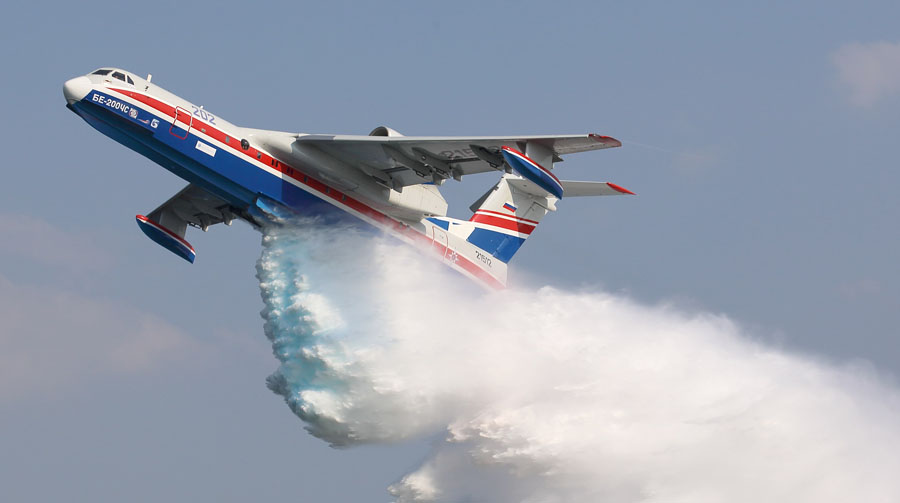
The Russian Defense Ministry has confirmed that a Beriev Be-200 air tanker crashed in Turkey Saturday. There was no immediate word on the condition of the five Russian army personnel and three Turkish officers that were on board.

A low resolution video (below) showed what may have been the aircraft dropping water then continuing toward what appeared to be rising terrain.

The aircraft was being leased from Russia and went down near Adana, the Russian Defense Ministry said.

The Turkish state news agency Anadolu reported that rescuers who rushed to the scene had video footage showing plumes of smoke from the site.

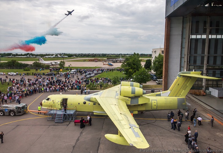
Beriev began manufacturing the Be-200 in 2003. It is one of the few purpose-built air tankers, designed primarily for fighting wildland fires. The aircraft can land or take off on water or land, and the firefighting version can scoop water to refill its 3,000-gallon tanks. It can be converted to haul passengers or serve as a search and rescue aircraft, landing on water to retrieve victims if necessary.

Roughly 10 years ago U.S. Forest Service employees traveled to Taganrog, Russia the home base of the Beriev company, to conduct tests to determine if the Be-200 could be approved by the Interagency Airtanker Board (IAB). At the time, we heard unofficial reports that it met the criteria for water-scooping air tankers, but tests were not completed for dropping fire retardant.

Be-200ES air tanker
File photo of Be-200ES air tanker. Beriev photo.

Thanks and a tip of the hat go out to Tom.

Smoke forecast and air quality, August 13, 2021

Forecast for near surface smoke
Forecast for near surface smoke at 6 p.m. PDT Aug 14, 2021.

Above is the forecast for the distribution of smoke from wildfires Saturday at 6 p.m. PDT August 14, 2021.

The map below shows the actual air quality in the Western U.S. at 6:46 p.m. PDT August 13, 2021, based on PM2.5 and PM10.

Air quality, at 6:46 p.m. PDT Aug 13, 2021
Air quality, at 6:46 p.m. PDT Aug 13, 2021, by AirNow.gov

To see other articles on Wildfire Today tagged “smoke”, including the most recent, click HERE.

Smoke linked to thousands of COVID-19 cases on West Coast

More than half of the 22 coronavirus fatalities in Calaveras County, CA were tied to smoke

Satellite photo, wildfires,
As the sun begins to set on the west coast, gray smoke from wildfires can be easily distinguished from white clouds. NOAA, GOES 17.

From the San Francisco Chronicle, Aug. 13, 2021


The presence of wildfire smoke last year during the pandemic may have been responsible for at least 19,000 additional coronavirus cases on the West Coast, and 700 subsequent deaths, a new study shows.

The study, published Friday in the journal Science Advances, offers the most detailed accounting yet of how the devastating 2020 wildfire season is believed to have amplified the coronavirus outbreak. It traces increases in infections to periods of smoke in more than 50 counties in California, Oregon and Washington.

While a correlation between wildfire smoke and COVID-19 doesn’t prove causation, the study’s authors say the tie is no coincidence. Plenty of research since the start of the pandemic has suggested that exposure to smoke’s primary unhealthy component PM 2.5, which refers to particulate matter that is 2.5 micrometers in size or smaller, compromises people’s immunity and increases susceptibility to COVID-19. Scientists also hypothesize that the virus may be spread by the particles.

The team’s models crunched coronavirus numbers in 92 counties during non-smokey periods from March 15 to Dec. 16 and how these numbers changed when wildfire smoke brought particulate pollution. The area that the researchers examined covered 95% of the population in California, Oregon and Washington. They excluded areas that did not have sufficient data for modeling.

Richard Spring Fire prompts evacuation of Lame Deer, Montana

The fire has burned more than 170,000 acres in the southeast part of the state

7:03 p.m. MDT August 13, 2021

Map of the Richard Spring Fire
Map of the Richard Spring Fire, 12:31 a.m. MDT August 13, 2021

The Richard Spring Fire reported August 8, 2021 10 miles southwest of Colstrip, Montana has burned along the Tongue River threatening multiple communities. It has been driven by strong winds through brush, short grass, and timber 90 miles east of Billings.

Evacuations are in effect for Lame Deer, Muddy Cluster, and Rosebud Cut Across.

Highway 212 is closed between Broadus and Crow Agency to all non-residents. Highway 39 is currently open, but this could change at any time.

The north side of the fire spread to the massive coal mines west of Colstrip. The south side, 12 miles to the south, jumped across US Highway 212 east of Lame Deer and has moved into heavier fuels. That is the area that showed the most activity in a 12:31 a.m. mapping flight Friday and is where many resources are currently concentrated.

Richard Spring Fire Montana
Richard Spring Fire. Burnout along Highway 212 August 11, 2021. InciWeb photo.

Firefighters, including four Hotshot crews, are constructing hand line south of Highway 212 in an effort to contain the fire north of the Lame Deer Divide Road. Air tankers and helicopters are supporting the ground-based crews.

Lame Deer Fire

A fire 4 miles west of the Richard Spring Fire, the Lame Deer Fire, has burned 5,427 acres just north of Highway 212 and the community of Muddy. It is 3 miles west of Lame Deer. Firefighters took advantage of the precipitation to construct line and conduct burnout operations. Those efforts have been successful so far, and crews now have initial control lines constructed around most of the perimeter and will continue to strengthen those lines.

Dixie Fire grows by 25,000 acres

Threatens Westwood and Chester

6:30 p.m. PDT August 14, 2021

Dixie Fire map NW Side
Dixie Fire map NW Side. The white line was the perimeter at 6:30 a.m. PDT Aug 14, 2021. The blue line was the perimeter 22 hours before. The yellow areas represent intense heat identified manually by the Infrared Analyst. Red dots are heat detected by a satellite at 1:51 p.m. PDT Aug. 14, 2021.

Here are some updated maps of the north half of the Dixie Fire. The south half is quiet.

Most of the fire activity Friday night and Saturday morning was:

  • Lassen Volcanic National Park;
  • Northeast and east of Chester;
  • South and southeast of Westwood;
  • West of Antelope Lake.
Dixie Fire map NE Side
Dixie Fire map NE Side. The white line was the perimeter at 6:30 a.m. PDT Aug 14, 2021. The blue line was the perimeter 22 hours before. The yellow areas represent intense heat identified manually by the Infrared Analyst. Red dots are heat detected by a satellite at 1:51 p.m. PDT Aug. 14, 2021.

Continue reading “Dixie Fire grows by 25,000 acres”

Four wildland firefighters receive minor injuries in vehicle rollover

Working on the Skyline Ridge Complex 22 miles southeast of Roseburg, Oregon

1:53 p.m. PDT August 12, 2021

Map of the Skyline Ridge Complex accident injuries firefighters
Map of the Skyline Ridge Complex of fires at 8:22 p.m. PDT August 11, 2021

Four firefighters assigned to the Skyline Ridge Complex of fires in Oregon were transported by ambulance Wednesday morning August 11 after their vehicle rolled over.

The Douglas County Sheriff’s Office reported that a crew vehicle transporting fire personnel from their night shift assignment on the Skyline Ridge Complex east of Canyonville struck approximately 60 to 70 feet of guardrail before driving up a hillside and rolling over. The crash resulted in non-life threatening injuries to four firefighters who were transported by ambulance to Mercy Medical Center in Roseburg, Oregon where they were treated and later released.

The call came in to 9-1-1 at approximately 9:53 a.m. of a single vehicle rollover crash in the 15000-block of Tiller Trail Highway roughly 10 miles east of Canyonville and Interstate 5.

The injured personnel are part of a 20-person crew assigned to the fire. Additional crew members traveling in two other vehicles were not involved in the accident.

Deputies determined the driver, a 38-year-old wildland firefighter from Salem, Oregon fell asleep at the wheel while returning to fire camp after working the night shift on the fire. Alcohol and speed were not contributing factors in the crash and no citations or arrests were made.

The Skyline Ridge Complex is a group of fires started from lightning on August 1, 2021 about south-southeast of Roseburg, Oregon. Combined, the fires have burned 3,546 acres.

These firefighters were very lucky. From 1990 through 2014, 22 percent of the wildland firefighter fatalities were the result of vehicle accidents.

Wildland firefighter fatalities 1990-2014

Articles on Wildfire Today tagged “sleep”.

Thanks and a tip of the hat go out to Kelly.