Oregon wineries suing PacifiCorp for 2020 wildfires

After a Lane County Circuit Court judge in Oregon denied PacifiCorp’s motion to dismiss the negligence claims back in December, KOIN-TV reports that a Willamette Valley winery is wanting accountability from utility companies after the devastating 2020 Labor Day fires.

Brigadoon Vineyards filed in June 2023 with negligence charges against Pacific Power — and its parent company PacifiCorp. KGW-TV reported last week that several vineyards in the Pacific Northwest have sued the utility company, claiming that the utility company’s  powerlines started some of the 2020 Labor Day fires, which tainted grape crops at numerous wineries with smoke wafting over Northwest vineyards during and after the 2020 firestorm.

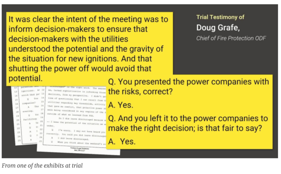
“It boggles the mind that they had an opportunity to turn off the power and they didn’t do it.”

Brigadoon argues in court that the Labor Day fires — the Santiam, Echo Mountain, Archie Creek Complex, 242, and South Obenchain  fires in western Oregon in 2020 — resulted from PacifiCorp’s electrical system failures and the utility’s decisons to not de-energize its powerlines — caused smoke to taint the winery’s grapes, which crippled wine production and the winery’s sales.  Multiple lawsuits filed by Willamette Valley vineyards and wineries against PacifiCorp, the parent company of electric utility Pacific Power, will proceed in court after several recent rulings. Attorneys for the winemakers plan to get other affected  businesses on board with the legal action.

Elk Cove Vineyards, Willamette Valley Vineyards, and Brigadoon Winery thus far are just three of the affected winemakers to sue PacifiCorp individually. The complaints were filed separately but are all substantively similar  — they each allege that PacifiCorp equipment failures ignited several of the Labor Day fires of 2020, and that the smoke from those fires then damaged grapes, the grape harvest, and wine sales for the wineries. Complainants are seeking almost  $16 million in damages.

Oregon vineyards

KOBI5 recently reported that Elk Cove Vineyards, Willamette Valley Vineyards, and Brigadoon Winery are just three of the winemakers to sue PacifiCorp so far, alleging that the power company’s lines, which they chose to not de-energize, started some of the 2020 fires that tainted or ruined the vineyards’ grape crops with heavy and longterm smoke.

Lawsuits from the 2020 Labor Day weekend fires have already cost PacifiCorp more than $73 million. Brigadoon Vineyards says PacifiCorp decided to not shut off power despite warnings from the National Weather Service and Oregon officials that a “historic red-flag-warning weather event would occur, producing catastrophic winds in excess of 50 mph, and hot dry air that was likely to cause electrical system failures that would cause dangerous fires.”

courtroom exhibit in the PacifiCorp trial

Brigadoon Vineyards says they were unable to sell wines to the public at their regular price — if at all –and the winery claims that it lost retail shelf spaces and also suffered reputational damage, which may take 5 to 7 years to recoup after the fires. Brigadoon is just one of several wineries, including Willamette Valley Vineyards, suing PacifiCorp for damages from the 2020 Labor Day fires.

Willamette Valley Vineyards

“Our grapes were just in the process of ripening at that time. And so many of the growers in the wineries were not able to use significant amounts of fruit they had grown,” said Jim Bernau, the founder of Willamette Valley Vineyards.

Australia 4 years ago today


December 31, 2019 Australia bushfire smoke

Very large bushfires in December of 2019 were rapidly spreading through areas of New South Wales and Victoria in southeast Australia, leaving behind hundreds of thousands of burned hectares, blackened forests, and destroyed structures in their wakes.

Victoria
Authorities in Victoria confirmed that at least 43 structures were destroyed in the Gippsland region where more than 400,000 hectares (988,000  acres) had burned. Many of the structures were in the Sarsfield and Buchan areas.

The military was activated to assist firefighters and the public. The Australian Defense Force deployed Black Hawk and Chinook helicopters, as well as fixed-wing aircraft and Navy vessels for firefighting support and evacuations. Authorities were considering using helicopters to fly in food and other supplies to people cut off by fires and road closures. Fire aviation specialists from the United States and Canada arrived in Australia to help manage aircraft.

12/31/2019 New South Wales

New South  Wales
At least 40 homes were destroyed by fires in Conjola Park on the south coast of NSW as the fire burned through on December 31. Many residents fled to the beach.

Many structures burned in Cobargo, including some of those along Princes Highway, the main street going through the town.

An engine crew from Fire and Rescue New South Wales Station 509 Wyoming recorded the video below showing the moment their truck was overrun by a fire south of Nowra, NSW. The crew was forced to shelter in their truck as the fire front passed through. The video was posted by NSW Rural Fire Service December 31, 2019 local time.

Maybe it wasn’t the hurricane that blew up the Maui wildfires

Scientists have introduced a new theory for the cause of the Maui fires in August, and the theory casts doubt on previous assumptions that linked the wildfires to nearby Hurricane Dora. Weather models show the fires were actually blown by the same meteorological phenomenon that’s often behind California’s worst wildfires — a downslope windstorm (see Rattlesnake).

Nearly four months after the Lahaina Fire that devastated Maui — leaving 100 people dead and 6,000 still homeless — scientists have clarified a new theory; according to a report by the Daily Mail, video footage documenting the fire revealed a wind-driven firestorm, but the power outages during the firestorm left scientists uncertain about which factors had caused the fire behavior.

Atmospheric researchers have now simulated the weather and fire trends in western Maui. In Lahaina, the main cause of the fires was a strong high-pressure system north of Hawai’i that intensified the easterly tradewinds, and when those winds ran up against the slopes in West Maui, the speed increased as the winds blew downhill. When they hit Lahaina they’d reached hurricane strength.

Simulations by the University of Nevada-Reno and the State University of New York at Buffalo showed that sustained winds in Lahaina on August 8 were nearly 80 mph with gusts exceeding 90 mph. Studies by the University of Hawaii and the University of Washington simulated similar wind speeds.

Cliff Mass, an atmospheric sciences professor at the University of Washington who simulated the Maui windstorm, said the combination of fuels, strong winds, and ignition sources is a common set-up for destructive wildfires.

“There’s a real story for Californians here because what happened in Maui, what happened in the Marshall Fire, what happened at Paradise … they’re all the same thing,” Mass told the San Francisco Chronicle.

The Chronicle reported that videos from Lahaina showed a wind-driven fire, but that because weather stations in the area had lost power during the fire, researchers could not be certain about exactly which factors had  combined to create the firestorm. Many had initially attributed the disaster to Hurricane Dora near the island.

Below is a  forecast vertical cross-section of the situation on the island at about 11 a.m. Hawaii time. Cliff Mass explains that winds are shown by the color shading and arrows.  “The solid lines are potential temperature. An extraordinarily high amplitude wave had formed, with air descending the western side of  the Maui Mountains, accelerating as it plummeted toward Lahaina. At low elevations, the flow abruptly ascended, in a feature often termed a hydraulic jump.”
Cliff Mass illustration -- Maui Mountains
Cliff Mass illustration — Maui Mountains

He said the Lahaina situation involved a wet winter, followed by a dry summer, causing grasses to grow exceptionally in the spring to create a  dense fuel load, ready to burn.

Nearly 6,200 people still struggle to find housing while residents and their beloved Maui town of Lahaina works to rebuild.

~ Thanks and a tip of the hardhat to Jim. 

August ‘pyrotornado’ in Canada validated by researchers

A video that claimed to show a rarely-seen wildfire phenomenon went viral in August. Now, researchers have confirmed its legitimacy.

An “extensive investigation” led by researchers at Western University’s Northern Tornadoes Project in Ontario started after the video of a vortex above British Columbia’s Gun Lake was shared by numerous news outlets after it was recorded on August 18.

“The Northern Tornadoes Project has been investigating this event since that time — very carefully, given this was potentially the first fire-generated tornado that we have recorded,” researchers said.

Researchers first confirmed the location and date of the video, then had to determine whether the vortex shown in the video met the definition of a tornado. The project was able to determine the tornado’s validity through multiple visual indications from the recording, including the presence of a spray vortex at the base of the tornado, how the vortex formed and the position of the vortex over the fire, all of which matched the scientific research related to fire-generated tornadoes.

“Though the terminology in this area of science is still developing, it should be pointed out that this intense vortex was not a brief, fire-filled ‘fire whirl‘ but an actual tornado that is sometimes referred to as a pyrotornado,” the researchers said. “This is the first such fire-generated tornado recorded by [the Northern Tornadoes Project], and appears to be the most thoroughly documented fire-generated tornado so far in Canada.”

The researchers confirmed that, yes, the event is classified as a tornado. The full extent of the damage from the tornado isn’t yet known, but the project says evidence is trickling in slowly.

The pyrotornado isn’t the only one that’s been thoroughly studied. The “world’s first wildfire tornado” was captured on video in 2003 during a wildfire outside of Canberra, Australia. The fire destroyed 500 homes and killed four people. The damage was worsened when the pyrotornado emerged.

“The Canberra fire tornado of 2003 was rated an EF3 on the Enhanced Fujita Scale, with horizontal winds of 160 miles per hour, roughly equivalent to a Category 5 hurricane,” an article from Smithsonian Magazine reads. “As the first documented example of its kind, it was a milestone — another harbinger of 21st-century fire.”

A similar event was recorded during the 2018 Carr Fire in Redding, California, dubbed “the most destructive fire in National Park System history.” The fire destroyed 1,614 structures, killed seven people, and burned 229,651 acres. The fire also has a place in history for the pyrotornado it generated, which has since helped forecasters’ and scientists’ ability to identify future fire-generated tornadoes. NOAA researchers studied the pyrotornado, which had many similarities to the Gun Lake tornado.

“A key factor in the vortex formation was the development of a fire-generated ice-topped cloud (i.e., a pyrocumulonimbus), which reached as high as 12 km aloft,” NOAA said. “These observations will help forecasters and scientists identify, and potentially warn for, future destructive fire-generated vortices.”

A video that claimed to show a rarely-seen wildfire phenomenon went viral in August. Now, researchers have confirmed its legitimacy.

An “extensive investigation” led by researchers at Western University’s Northern Tornadoes Project in Ontario started after the video of a vortex above British Columbia’s Gun Lake was shared by numerous news outlets after it was recorded on August 18.

Burning Alaskan permafrost increasing methane emissions

Posted on Categories ResearchTags , ,

The flames have died out on Alaska’s largest river delta, but emissions are still seeping out of the tundra’s ground.

A recent NASA study found that methane “hot spots” in the Yukon-Kuskokwim Delta are more likely to be found where wildfires burned into the tundra. The greenhouse gas reportedly originates from decomposing carbon stored in the tundra’s permafrost for thousands of years.

“We find that [methane] hotspots are roughly 29 percent more likely on average in tundra that burned within the last 50 years compared with  unburned areas, and that this effect is nearly tripled along burn scar perimeters that are delineated by surface water features,” the researchers said. “Our results indicate that the changes following tundra fire favor the complex environmental conditions needed to generate emission hotspots.”

Mackenzie Delta, Northwest Territories

The correlation also nearly tripled in areas where fires burned to the edge of a lake, stream, or other body of standing water, according to NASA. The highest ratio of methane hot spots occurred in recently burned wetlands. Researchers detected roughly 2 million hot spots across 11,583 square miles. The team believes more hot spots could soon emerge.

“By some projections, the fire risk in the Yukon-Kuskokwim Delta could quadruple by the end of the century due to warming conditions and increased lightning storms – the leading cause of tundra fires,” they said.

Alaska had two of its largest tundra fires ever in 2022. The East Fork Fire ignited on May 31 after a lightning strike, and burned more than 150,000 acres along the Yukon River. The Apoon Pass Fire, the second largest, burned 84,130 acres.

Previous research found that the majority of yearly methane emissions from Alaska’s tundra occur during the cold season between September and May, indicating that total emissions are sensitive to soil climate and snow depth.