Fire officials said if winds and slope align at the fire Sunday, there is a possibility for extreme fire behavior again
3-D map of the Pine Gulch Fire looking north. The red line was the fire perimeter at 8:08 p.m. MDT August 8, 2020. The white line was the perimeter three days before.
The Pine Gulch Fire 15 miles north of Grand Junction and 19 miles west of Parachute, Colorado has been very active for the last three days, spreading to the west, southeast, and especially to the north (see map below). The growth on August 7 was described as explosive, and at 7 a.m. Sunday morning a large smoke column was forming, which is unusual for that time of day. The fire has burned 23,882 acres.
Smoke from the fire has been moving into eastern Colorado and other states to the east and northeast.
The Pine Gulch Fire at 7 a.m. MDT August 9, 2020 as seen from the Incident Command Post. InciWeb.
(To see all articles on Wildfire Today about the Pine Gulch Fire, including the most recent, click HERE.)
From the Incident Management Team Sunday morning at 10 MDT:
Humidity recovery was poor again overnight. Humidity will decrease through the day [Sunday] with an expected minimum relative humidity as low as 8%. Temperatures are expected to be 85-88 degrees. Winds out of the southwest are again expected to pick up to 15 mph through the day. If winds and slope align over the fire, there is a possibility for extreme fire behavior again today.
Shot from Colorado National Monument August 7, 2020 about 15 miles Southwest of the Pine Gulch Fire. The view is looking towards the northeast and shows some of the explosive activity on the northern front Friday and the huge smoke plume extending to the east. Photo by Jennifer Deering.
Garfield County issued an evacuation order for residences on CR 202 and a pre-evacuation order for all residences on county roads 204, 207, 209, and Clear Creek Road. For more information on evacuation orders, visit https://garfieldcounty.net/.
Map of the Pine Gulch Fire. The red line was the fire perimeter at 8:08 p.m. MDT August 8, 2020. The white line was the perimeter three days before.
The map shows the distribution of smoke from vegetation fires at 1:58 p.m. MDT August 9, 2020. NOAA.
The map shows the distribution of smoke from vegetation fires at 1:58 p.m. MDT August 9, 2020. The largest producer is the Pine Gulch Fire in Colorado.
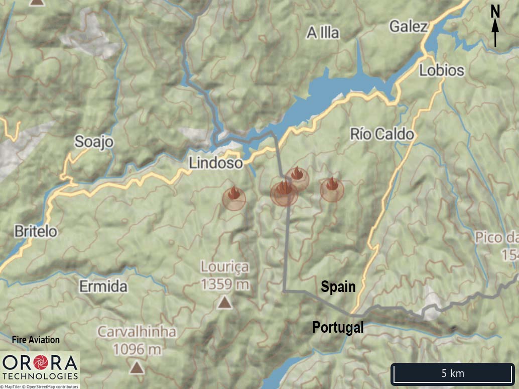
A Portuguese water-scooping air tanker crashed in Spain on August 8 while battling a wildfire that started near Lindoso, Portugal and burned across the international border. The pilot, Jorge Jardim, 65, was killed and the Spanish co-pilot was seriously injured.
Below are excerpts from an article at the Portugal Resident August 8, 2020:
The tragedy happened mid-morning as the plane was taking part in aerial attacks on a fire in the Peneda-Gerês national park at Lindoso, Ponte da Barca.
The downed plane had just finished a ‘scooping’ (collection of roughly 5000 litres of water) and was preparing to drop the load in an arc at the head of the fire.
By the time rescue workers got to the wreckage, both victims were in cardio-respiratory arrest. SAV (advanced life-support) technicians managed to ‘bring back’ the Spanish co-pilot, but were unable to resuscitate the 65-year-old pilot.
Eduardo Cabrita, minister for Interior Administration, issued a note of regret Monday afternoon, presenting his “heartfelt condolences” to the family, friends and colleagues of pilot Jorge Jardim who made up part of the special aerial fire combat force run by the Portuguese branch of the international company Babcock.
Mr Cabrita also wished for the full recovery of the co-pilot, saying “in this tragic moment I would like to send a word of solidarity to all those who give such selfless service to the country in the combat of fires”.
He also thanked Spanish authorities for their help in the difficult recovery operation.
The aircraft was a Canadair CL-215 (EC-HET) manufactured in 1975.
At the time of the accident, seven Portuguese and four Spanish aircraft were working on the fire.
The investigation will be conducted by Spanish authorities since it occurred on the Spanish side of the border.
YouTube has aerial footage of the crash site apparently filmed shortly after the incident which shows a small vegetation fire spreading uphill away from the wreckage. There are also photos on Twitter.
Our sincere condolences go out to the family, friends, and co-workers of Mr. Jardim and hope for a full recovery of the co-pilot.
The fire has burned over 29,000 acres north of Beaumont, California
Updated August 7, 2020 | 12:43 p.m. PDT
Smoke over the Apple Fire as seen from Snow Peak, looking southeast at 12:28 p.m. PDT August 7, 2020.
The U.S. Forest Service said at about 11:30 a.m. Friday that the very large amount of smoke on the east side of the Apple Fire is the result of a burn out operation:
This is a planned event and has adequate aerial support and ground resources in the area. The smoke is a result of crews doing a burn out operation to remove fuels in front of the fire.
Smoke over the Apple Fire as seen from Bear Mountain, looking southeast at 12:27 p.m. PDT August 7, 2020.U.S. Forest Service photo.
August 7, 2020 | 6:50 a.m. PDT
Map of the Apple Fire. The red line was the perimeter at 10:58 p.m. PDT August 6, 2020. The white line was the perimeter about 48 hours before.
More evacuation warnings were issued Thursday for the Apple Fire which has been burning since July 31 north of Beaumont and Banning in southern California. One of the areas on the list is the community of Morongo Valley. A warning is one level below an evacuation order.
(To see all articles on Wildfire Today about the Apple Fire, including the most recent, click here.)
“There is a potential threat to life and/or property,” the Sheriff’s Department said. “Those who require additional time to evacuate, and those with pets and livestock should leave now.”
This photo of the Apple Fire was shot by Sandy Wood August 1, 2020. It is looking east from Mill Creek in Forest Falls up to Mill Creek Jumpoff, with Galena Peak burning to the right.
A mapping flight at 10:58 p.m. Thursday determined that the Apple Fire had burned 29,267 acres. The largest concentrations of heat at that time were on the east side as it burned into Willard Canyon and Bear Wallow Spring.Another area of intense heat was on the northwest side of the fire where it was spreading near Cedar Mountain.
Two Very Large Air Tankers, a DC-10 and a 747, at the San Bernardino Air Tanker Base 16 miles northwest of the Apple Fire. USFS photo.
From the Incident Management Team Thursday night:
“Firefighters made good progress in the Oak Glen area and were able to build direct line just below the fire. The fire is headed towards a rocky area. The smoke in this area was due to heavy fuels burning on the top of Yucaipa Ridge.
“The fire burned through heavy fuels in the Millard Canyon area, but stayed in place on the western slopes of Millard Canyon. Planes and helicopters built a line of fire retardant today in preparation for firing out a portion of the vegetation this evening. The goal is to build a containment line to prevent fire movement to the east to the communities of Morongo Valley and Pioneertown.
“The fire has stayed in place in the San Gorgonio Wilderness to the north. Firefighters have made good progress with mop-up and backhaul of trash and excess equipment in the origin area of Cherry Valley and Banning Canyon; this area will be in patrol status tomorrow.”
Pyrocumulus clouds form over the Pine Gulch Fire north of Grand Junction, Colorado, August 5, 2020. Photo by Jennifer Deering.
Since the lightning-caused Pine Gulch Fire was discovered July 31 it has burned 11,846 acres 15 miles north of Grand Junction, Colorado. It was very active on Wednesday with most of the growth, an additional 6,161 acres, occurring on the northeast and northwest sides. The fire is expanding beyond lands managed by the Bureau of Land Management onto private property.
(To see all articles on Wildfire Today about the Pine Gulch Fire, including the most recent, click HERE.)
Aerial resources are available again Thursday to assist firefighters on the ground. Four more engines and additional crews will be added to a “swing shift.” These crews will work the late afternoon to early morning hours on the south side of the fire to continue operations initiated during the day.
Map of the Pine Gulch Fire at 9:31 p.m. MDT August 5, 2020.
A Red Flag Warning is in effect in the area from 11 a.m. to 8 p.m. due to gusty winds and hot, dry conditions. The forecast calls for wind gusts of 25 to 30 mph in the afternoon with very low humidity – near 10%. Conditions over next two days will be critical on the fire as activity is expected to increase, with the potential for high rates of spread.
Resources on the Pine Gulch Fire include 4 hand crews, 16 engines, 4 helicopters, and a variable number of air tankers for a total of 292 personnel.
A Type 2 Incident Management Team led by Incident Commander Troy Hagan is assigned.
Map of the Stagecoach Fire showing heat detected by a satellite as late as 3:12 a.m. PDT August 6, 2020.
The Stagecoach Fire 21 miles east of Bakersfield was very active Wednesday, putting up a large column of smoke as it spread into more rugged terrain primarily to the east and southeast. The fire is 9 miles south of the town of Lake Isabella.
Stagecoach Fire, from Breckenridge, at 7:16 am PDT Aug 6, 2020.
Wednesday at 7 p.m. fire officials with Kern County said it had burned 4,250 acres. Heat detected by satellites at 3:12 a.m. Thursday shows the fire could have grown by another 2,000 acres during the night (see map above). The unconfirmed satellite data indicates the Stagecoach Fire has moved into the Sequoia National Forest after burning on private property and land protected by the Bureau of Land Management.
Evacuations are in effect.
Stagecoach Fire as seen from Breckenridge, looking east at 6:18 pm PDT August 5, 2020.
As of Wednesday morning the Stagecoach Fire south of Lake Isabella in Kern County California had burned 4,100 acres, a spokesperson for CAL FIRE said. During the afternoon the intensity increased, sending up a large smoke column.
At least two homes have been destroyed as the fire continues to spread to the east.
Map of the Stagecoach Fire showing heat detected by a satellite as late as 2:54 p.m. PDT August 5, 2020.
Not much information about the fire is being released by Kern County.
To see all articles on Wildfire Today about the Stagecoach Fire, including the most recent, click here.
Air Tanker 944, a 747, drops on the Stagecoach Fire August 4, 2020. Photo by @SoCalFirePhoto.CAL FIRE Dozer 1743 on the Stagecoach Fire. CAL FIRE photo.Air Tanker 944, a 747, drops on the Stagecoach Fire August 4, 2020. Photo by @564fire.