Globe Hotshots, Mangum Fire, June 18, 2020. Photo by Mike McMillan. The parallel line pattern is a result of swinging the drip torch from side to side while walking.
Strategic burning operations are often conducted at night, giving firefighters more control over the behavior of the fire they are igniting.
Mike McMillan, a Task Force Leader on the Mangum Fire in northern Arizona, sent us these photos of the Globe Hotshots during a recent burning operation on the east side of the fire.
Thanks Mike!
Globe Hotshots, Mangum Fire, June 18, 2020. Photo by Mike McMillan.
3-D map showing the Central Fire which was mapped at 12:08 a.m. MDT June 22, 2020. The Bush and Bighorn Fires can be seen in the distance.
The Central Fire just east of New River, Arizona spread to the east Sunday to the top of New River Mesa, growing to 4,517 acres according to a mapping flight at 12:08 a.m Monday.
At a virtual community meeting Sunday night Ralph Lucas, the Operations Section Chief of Alan Sinclair’s Type 1 incident management team running both the Central and Bush Fires, said he did not expect the Central Fire to grow much more:
But when I last spoke to the Incident Commander on the Central Fire, he was confident with what they had going on, and thinks that we might be able to get around this thing and not see a drastic increase in acreage, but only time will tell depending on the weather and the wind.
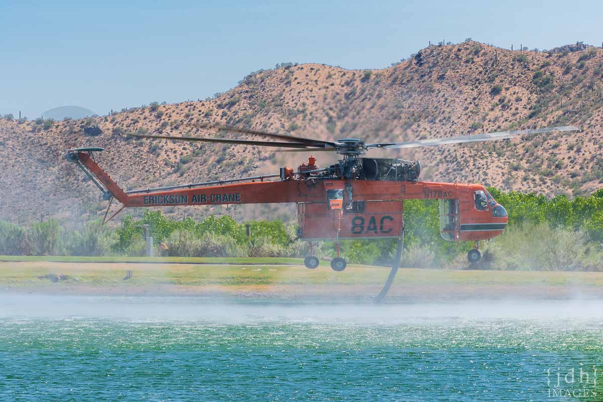
Skycrane “Isabelle” N178AC, a Sikorsky S-64F from Erickson Incorporated fills her 2,500 gallon tank at the Rancho Manana Golf Club while fighting the nearby Central Fire burning in the Tonto National Forest near New River, AZ on June 21, 2020. Photo by John Hall.
— Daisy Mtn Fire & Medical (@DaisyMtnFire) June 20, 2020
(Originally published at 12:47 p.m. MDT June 21, 2020)
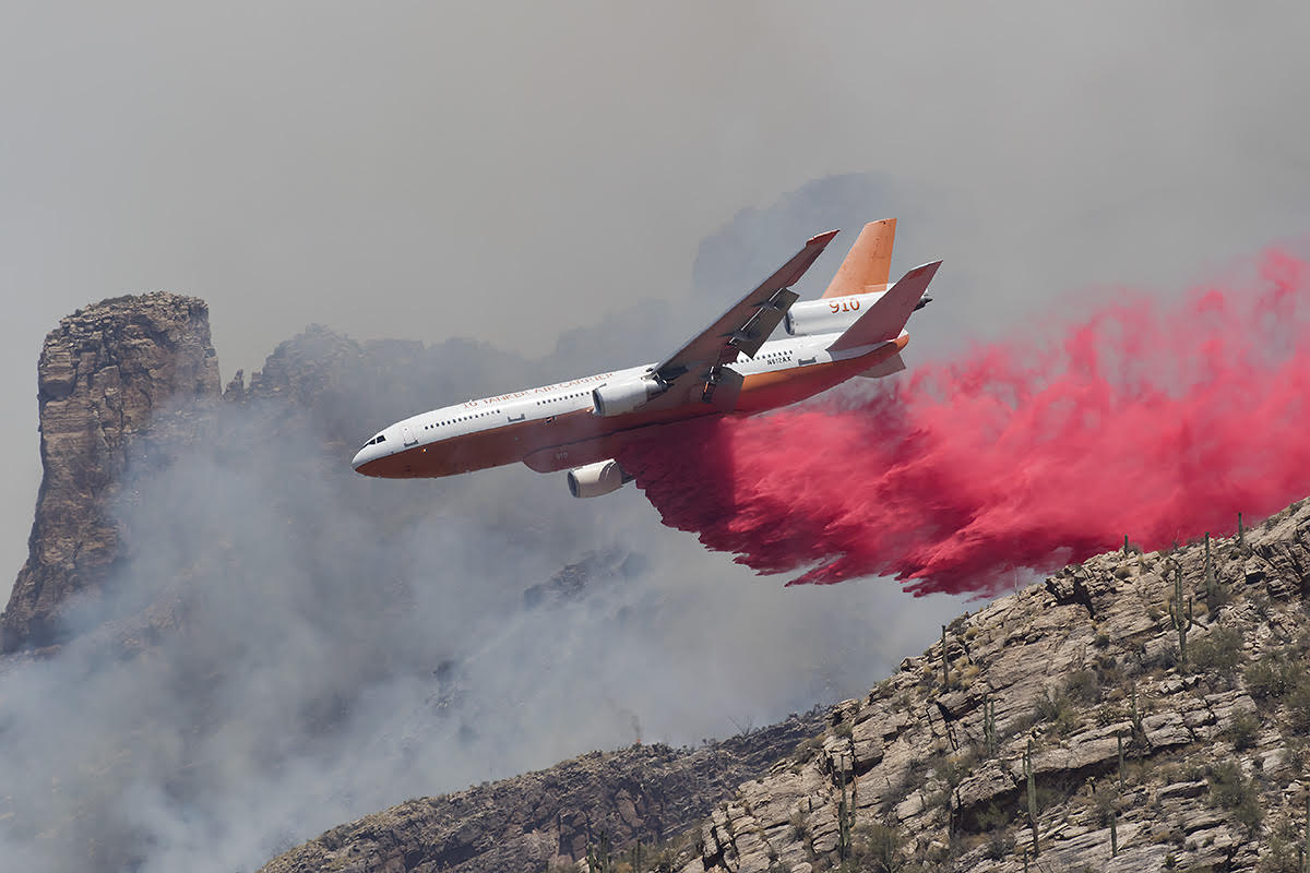
Air Tanker 914, a DC-10, drops retardant on the Central Fire, June 20, 2020. Photo by JDH Images.
Eleven months ago firefighters battled a wildfire north of Phoenix about 35 miles north of Phoenix, 4 miles east of Interstate 17. There was confusion about the name of the fire, switching from Central to Daisy and back to Central.
Saturday the same thing happened in the same location. A fire started in the footprint of the 2019 Central Fire. The name changed from Central to Daisy and back to Central.
Red dots represent heat on the June 20, 2020 Central Fire detected by a satellite at 3:21 p.m. MDT June 20, 2020. Retardant from the July 20, 2019 Central Fire is visible in the background satellite photo taken August 12, 2019.
In the satellite photo above taken August 12, 2019, 23 days after the first Central Fire, you can make out retardant which was dropped by air tankers. Within those retardant lines are superimposed red dots representing heat on the June 20, 2020 Central Fire detected by a satellite at 3:21 p.m. MDT June 20, 2020.
The Southwest Coordination Center lists the current Central Fire at 2,000 acres. Since the Saturday afternoon overflight, satellites have not been able to detect any large heat sources on the fire, but it is likely burning, or was burning, in light fuels such as grass, and cooled quickly between overflights.
Last year we made the map below:
Map showing the location of the Central Fire 35 miles north of Phoenix at 3:21 p.m. MDT July 20, 2019.
The Incident Management Team on the Bush Fire northeast of Phoenix is managing the Central Fire.
The Bush Fire grew Saturday by 9,171 acres to bring the total up to 184,531 acres. Firefighters have had success in recent days stopping the spread at Highways 87 and 188. They are closely watching the south side as it backs slowly downhill through light vegetation to Apache Lake and the Salt River.
The Central and Bush Fires in the Phoenix Area, June 21, 2020.
Forecast for the distribution of smoke from wildfires Saturday evening
Forecast for the distribution of smoke from wildfires at 7 p.m. MDT June 20, 2020. NOAA HRRR-Smoke
The forecast for the distribution of smoke from wildfires at 7 p.m. MDT Saturday looks rather bleak for areas of Arizona, New Mexico, Texas, and Oklahoma.
Firefighters have been conducting back burns out ahead of the fire
(Originally published at 10:09 a.m. MDT June 20, 2020)
3-D map of the Bighorn Fire looking southeast at 10:12 pm MDT June 19, 2020.
The Bighorn Fire north of Tucson, Arizona grew by 5,740 acres Friday to bring the total up to 42,798 acres.
Firefighters have been conducting back burns out ahead of the fire which they hope will serve as barriers to fire spread south of the community of Oracle along Old Mount Lemmon Highway near Peppersauce. They have also been constructing firelines on the west side of the Catalina Highway.
(To see all articles on Wildfire Today about the Bighorn Fire including the most recent, click here.)
Map of the Bighorn Fire. by the Incident Management Team, June 20, 2020.
The map below shows the growth of the Bighorn Fire over a 24-hour period.
The red line was the perimeter of the Bighorn Fire detected by a mapping flight at 10:12 p.m. MDT June 19. The yellow line was the perimeter about 24 hours before.
Firefighting resources assigned to the fire include 20 hand crews, 64 engines, 18 water tenders, 6 dozers, and 7 helicopters for a total of 894 personnel.
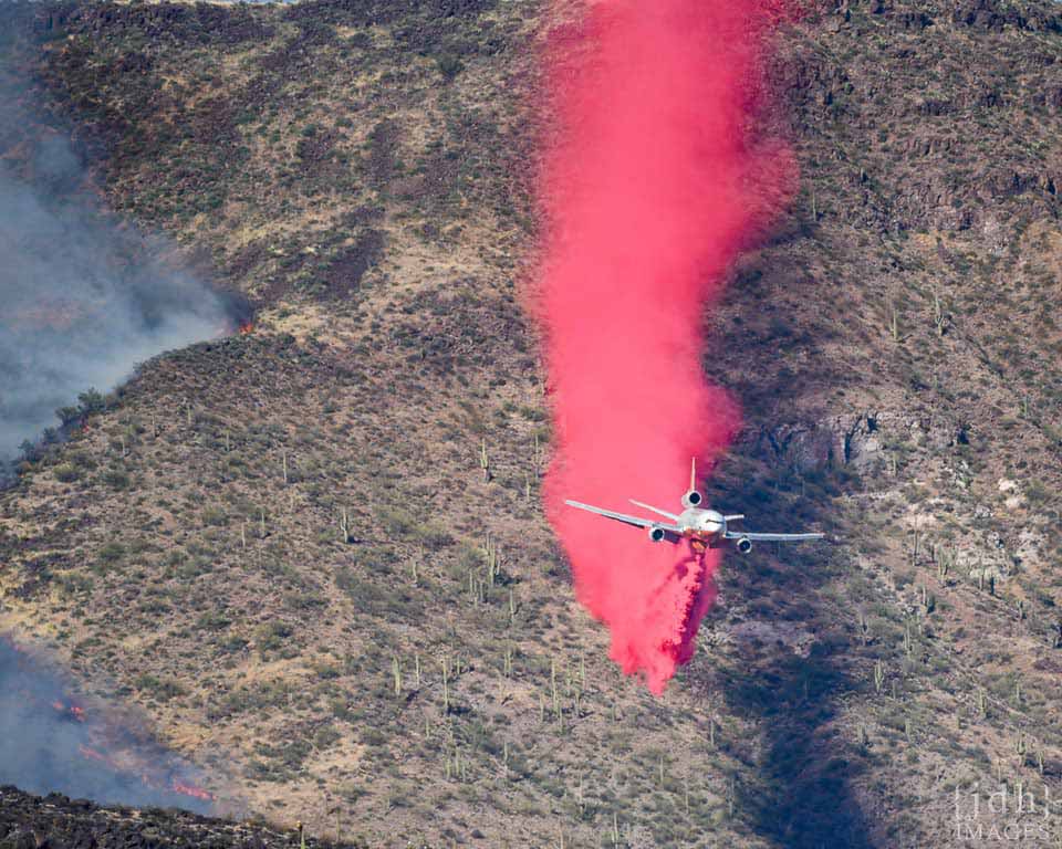
Tanker 910, a DC-10 operated by 10 Tanker Air Carrier drops on the Bighorn Fire. N612AX. Ned Harris photo.
Firefighters are starting to get a pretty good handle on the Bush Fire. The perimeter has not changed in a couple of days and any smoke seen is from previously unburned interior islands or firefighters cleaning up the edges by burnout out to remove fuel that is new the firelines. The latest mapping shows it has burned 184,086 acres.
The Central Fire north of Phoenix east of New River, Arizona spread to the east Sunday to the top of New River Mesa, growing to 4,517 acres according to a mapping flight at 12:08 a.m Monday. More information about that fire is on Wildfire Today.
3-D map showing the Central Fire which was mapped at 12:08 a.m. MDT June 22, 2020. The Bush and Bighorn Fires can be seen in the distance.Air Tanker 914, a DC-10, drops retardant on the Central Fire, June 20, 2020. Photo by JDH Images.
The red line was the perimeter of the Bush Fire detected by a mapping flight at 11:33 p.m. MDT June 19. The green line was the perimeter about 24 hours before.
Firefighters on Friday made more progress in tying in the east edge of the Bush Fire along Highway 188 north of Theodore Roosevelt Lake. On Saturday they will be burning along the SR 87 / Beeline Highway to create a buffer for fire backing downslope from the top of Mount Ord. Firefighters are using aerial ignition from helicopters to help slowly back the fire downslope to minimize post-fire impacts in the area.
A fixed wing mapping flight Friday night at 11:33 MDT determined that the fire had burned 174,397 acres, a 24-hour increase of 23,397 acres.
For all articles on Wildfire Today about the Bush Fire northeast of Phoenix including the most recent, click here.
Vicinity map of the Bush Fire east of Phoenix. The red line was the perimeter detected by a mapping flight at 11:33 p.m. MDT June 19. The green line was the perimeter about 24 hours before.
On the southeast side, smoke will also be visible as the fire continues to burn a large pocket of unburned vegetation within the fire’s interior.
Dee Hines, an Information Officer for the Bush Fire, said firefighters are allowing the south edge of the fire north of Apache Lake and the Salt River to naturally back slowly down the hill. Mr. Hines described the terrain as steep, rough, and rocky and the fire behavior as “creeping”.
The wind has moderated over the last couple of days, allowing firefighters to make significant progress on the huge fire. That trend is expected to continue through Tuesday with daytime breezes out of the southwest or west at 5 to 10 mph. But it being the desert, temperatures will be over 100 degrees in the lower elevations with relative humidity in the single digits. And there’s no chance of rain.
Areas that remain under “Go” evacuation notices include Brownsville, Jake’s Corner, Slate Creek, Pioneer Pass, Tonto Basin, Punkin Center, Sunflower, and residents and visitors to Apache Lake.
Firefighting resources assigned to the fire include 19 hand crews, 41 engines, 5 bulldozers, 19 water tenders, and 7 helicopters for a total of 759 personnel.
(Originally published at 8:58 a.m. MDT June 19, 2020)
The red line was the perimeter of the Bush Fire detected by a mapping flight at 11:18 p.m. MDT June 18. The yellow line was the perimeter detected by a mapping flight at 11:49 p.m. MDT June 17. The red dots represent heat detected by a satellite at 3:24 a.m. MDT June 19.
Over the last few days firefighters on the Bush Fire have dropped back to Highway 188 and initiated backfire and burnout tactics. After the fire made a run several days ago spreading rapidly downhill almost reaching the highway, they began using fire to remove the fuel near the highway allowing the flames to move up and merge with the main fire.
Judging from imagery collected by a fixed wing mapping aircraft and later a satellite at 3:24 a.m. Friday, it appears that they are close to completing that mission, a limited mission, of stopping the portion of the fire along Highway 188 on the east side of the fire. After they get it completely fired out along the highway, then they will need to hold those 28 miles of fireline between Jakes Corner (at the intersection of Highway 188 and 87) and the Lake Theodore Roosevelt dam.
Firefighters will still have two other large sections of the fire to secure: the 15 miles of Highway 87 south of Jakes Corner to Sunflower, and approximately 20 miles along the Salt River and Apache Lake on the south side. If the weather cooperates the piece north of Sunflower should not be very difficult to fire out after the east side is taken care of. The area along the river is very rugged and difficult to access, and there is a chance the fire could ignite spot fires across the river, which would be a whole new ball game in difficult country. The fire has been very active five miles west of Roosevelt near the river.
The fire is 12 miles south of Payson, 17 miles northeast of Mesa, and 28 miles northwest of Globe.
Thursday the fire grew by another 36,134 acres to bring the total up to 151,075 acres according to data collected on the 11:18 p.m. MDT June 18 mapping flight. The firing operations on the north side will add thousands more.
Helicopter drop on the Bush Fire June 18, 2020. InciWeb photo.
The red line was the perimeter of the Bighorn Fire detected by a mapping flight at 9 p.m. MDT June 18. The yellow line was the perimeter detected by a mapping flight about 24 hours before.
Thursday’s decreasing winds gave firefighters on the Bighorn Fire somewhat of a break, at least when compared with the difficult conditions on Wednesday that pushed the blaze northeast over Mt. Lemmon. Hand crews and personnel on fire engines were able to make progress, said Operations Section Chief Travis Mayberry.
(To see all articles on Wildfire Today about the Bighorn Fire including the most recent, click here.)
The lower wind speeds Friday could result in smoke being more visible in the communities near the fire. Weather forecasters expect temperatures of around 100 degrees with very low relative humidity.
Thursday night the fire was mapped at 37,058 acres, an increase of 5,850 acres in 24 hours.
Tanker 105 (foreground), an MD-87 (N295EA) operated by Erickson Aero Tanker, and Tanker 10, a BAe-146 (N472NA) operated by Neptune Aviation maneuver over the Bighorn Fire. Ned Harris photo.
Fire managers expect growth to the northeast in Cañada del Oro and Alder Canyons on Friday. Crews working south of Oracle and San Manuel will tie in containment lines today, in preparation for additional firing operations Friday evening. Firefighters on Mt. Lemmon are using an assortment of tools, including controlled burning, to protect the communities along the Catalina Highway.
As the high winds that had been keeping the fire burning on Samaniego Ridge and the top of Ventana Canyon subside, the fire may move downslope at a moderate pace. Firefighters will have to wait to engage some sections of the fire until after it transitions onto less steep terrain.
(Originally published at 1:35 p.m. MDT June 18, 2020)
3-D map of the perimeter of the Bighorn Fire mapped by fixed wing aircraft at 10:33 p.m. MDT June 17, 2020.
Since it started June 5 from a lightning strike the Bighorn Fire five miles north of Tucson has been adding less than 4,000 acres every day, until Wednesday when strong winds pushed it past Mt. Lemmon, growing by about 13,000 acres to bring the total up to 31,208 acres.
Firefighting resources assigned to the fire include 15 hand crews, 60 engines, 8 helicopters, 12 water tenders, and 6 dozers.
From the Incident Management Team Thursday morning:
“Today, fire managers anticipate the fire will move towards Charouleau Gap, depending on wind direction and temperatures. Fire crews and air support are in place preparing and widening fire lines for this expected spread of the fire. On Mt. Lemmon, the fire moved through Oracle Ridge and generated spot fires in Stratton Canyon. Expect highly visible smoke as those areas burn together today. Crews working overnight implemented controlled burns along the Catalina Highway corridor. Firing operations will continue today, if necessary, to protect values at risk.
“Air operations including fixed-wing airtankers were up early this morning, dropping water and fire retardant to slow the fire’s spread. Winds will continue to be a factor today, but less so than yesterday. The fire burning in the Ventana Canyon area and along Samaniego Ridge will be monitored by air support today. Minimal downslope backing of the fire is anticipated in that area. Crews will tie together the two containment lines north of the fire perimeter to protect the communities of Oracle and San Manuel.”
Perimeter of the Bighorn Fire mapped by fixed wing aircraft at 10:33 p.m. MDT June 17, 2020.Bighorn Fire, undated or credited Inciweb photoBighorn Fire Progression. By the Incident Management Team.