
Two years ago, July 2021
News and opinion about wildland fire

The Golden Fire north of Bonanza, Oregon was estimated this afternoon at 2,052 acres with about 9 percent containment, after it burned 43 homes and 43 outbuildings during its initial runs. The incident management team — jointly staffed by the Oregon Department of Forestry and the State Fire Marshal’s Office — said 440 firefighters were working on the fire.
Fire behavior’s been active with wind-driven runs, but crews are now mostly holding the fire, which is burning in short grass, timber, and dry brush. High temperatures and low RH are expected to persist for at least the coming 48 hours, with winds picking up in the afternoons; incident managers are concerned that a wind switch from the north later this week could test the fire’s containment lines.
The Golden Fire is about 11 miles north of Bonanza, Oregon.

Temperatures in the 90s with wind gusts up to 20 mph contributed to extreme fire behavior during initial attack. The fire spread rapidly in dry fuels and most of the destroyed homes were lost during the fire’s initial run on July 22. Since then downed powerlines, burned snags, and road conditions have limited crews’ access to portions of the fire. Resources with the State Fire Marshal’s Office are working on hotspots and mop-up around structures to protect additional homes.
Community meeting: Golden Fire Unified Command will host an outdoor information meeting this evening at 7 p.m. at the Bonanza School on Mission Street. Cooperating agencies include the U.S. Forest Service, BLM and Klamath County; no seating is available and residents are asked to bring lawn chairs. Details and more information on the fire are available from goldenfireinfo2023@gmail.com

Despite near-Red-Flag conditions, crews the last couple days were able to strengthen lines around the fire and take down snags and hazard trees around the perimeter. A fiber-optic cable for major portions of Klamath and Lake counties was severed by the fire, causing loss of 911 and Lakeview Interagency Fire Center dispatch operations, along with Lakeview hospital, pharmacy, county-wide internet, and phone service. Oregon Governor Tina Kotek invoked the Conflagration Act on July 22, boosting available resources from out of the area.
KDRV-TV reported that the number of destroyed homes is expected to rise as assessment teams are able to safely access those parts of the fire.
“Our hearts go out to the Bonanza community and those affected by the Golden Fire,” said Matt Howard, incident commander with ODF Team 2. “We grieve with the community and your loss. Our goal on this fire has been, and will continue to be, to contain this fire to minimize its impact. Our job now is to fully suppress this fire so the recovery process can begin. That is our commitment to you.”
KOIN-TV reported that FEMA announced yesterday it had authorized federal funding after determining destruction from the fire would constitute a “major disaster.”
The fire started Saturday on Bly Mountain, about 18 miles east of Klamath Falls.

The American Red Cross and the Klamath County Emergency Response Team have set up a shelter at Bonanza High School. The fire damaged fiber-optic communication lines from Klamath County to Lake County. At the time of the state’s FEMA request, the fire threatened homes around Bly Mountain and the communities of Beatty, Bonanza, and Dairy along with Highway 140 and Bonneville Power Administration transmission lines.
The Cocodona Trail is a curated route linking historic towns and paths through central Arizona. The rich history of the towns linked up through little-traveled ranges makes this a one-of-a-kind tour of the Grand Canyon State, and the Cocodona 250 race is set for May 6–11, 2024. Runners travel from Black Canyon City to Flagstaff; it’s the ultimate run across the ultimate places of northern Arizona!

The Cocodona 250 will take runners from Black Canyon City up into the Bradshaw Mountains to the historic little town of Crown King. The course then traverses more of the Bradshaws, up and over Mount Union, and snakes down into Prescott, where it cuts straight through town on Whiskey Row and out into the iconic Granite Dells. From Prescott the course heads up and over Mingus Mountain — on one of the world’s best motorcycle roads — into the billion-dollar copper camp known as Jerome, and then down and onward through Sedona, with its stunning red rock formations and high desert vistas. As runners leave Sedona, the course breaks into the pines of Flagstaff, finishing up and over Mt. Elden and into downtown Flagstaff. It is an extraordinary undertaking and treats runners to some of the best landscapes Arizona has to offer.

Harley Guy will be running the Cocodona 250 again to raise money for the Wildland Firefighter Foundation. Harley’s worked on a BLM engine and with Prescott Helitack and in other wildland fire roles; his past struggles with addiction led him to discover running and wildland fire. Help him raise awareness about the mental health issues that firefighters often struggle with — he will donate all his proceeds to the Foundation to help firefighters and their families during hard times.
“I was a wildland firefighter for two seasons,” explains Harley, “and I have seen firsthand what can happen when firefighters get injured, or worse. Firefighting is a hard job and doesn’t pay well. These men and women put their lives on the line to protect our public lands and can be away from loved ones for months at a time. An injury can mean a lack of finances causing hardship for firefighters and their families, which can be devastating.”

“When a firefighter passes away, this hardship can mean an even heavier burden to bear for the families,” adds Harley. “The Wildland Firefighter Foundation helps cover these expenses, helping both financially and with mental health care. Mental health is a big issue in the wildland community and unfortunately, there are many suicides and suicide attempts. The Foundation helps improve mental health for both firefighters and their families.”

Anthony Leach and Northern Arizona Productions posted a 5-minute video called Harley Runs to youtube, highlighting Harley Guy’s story. It’s a great little feature including Burk Minor’s explanation of what the Foundation does behind the scenes — and why.
Because he’s from Prescott, Harley says he’s felt the loss of loved ones in the community firsthand; he knew many of the Granite Mountain 19 who lost their lives on June 30, 2013 on the Yarnell Hill Fire. “This year is the tenth anniversary of that tragic event, and I want to raise money by running 250 miles during the Cocodona 250, as well as honoring and remembering the Granite Mountain Hotshots.”
Learn more about the Wildland Firefighter Foundation at wffoundation.org
You can learn more about Harley Guy’s effort at his Donation Page.
Cocodona 250 Charity Bib (Arizona) — $1875 raised of $5000 on July 24.
Firefighters in Greece are fighting to contain a wildfire west of Athens that has burned through forestland for a fifth day; Reuters and other news outlets are reporting that airtankers and reinforcements from several countries including Cyprus, France, Israel, and Italy are working the fire near Athens that’s burned homes and forced evacuations.

On Friday, Greek firefighters were working nearly 80 fires across the country, and the government on Friday announced relief measures for affected households, including financial aid and subsidies for residential rent.
Climate Crisis Minister Vassilis Kikilias urged residents to remain on guard. The risk of wildfires in the coming days will remain high, and more hot weather is forecasted. “We are having a very difficult three-day spell,” he said, “with extreme weather conditions and very high temperatures followed by strong winds.” He added that after a short respite, another heatwave was then forecast from the middle of next week.
With temperatures expected to hit 45°C (113°F) over the weekend, during the height of the summer tourist season, the Culture Ministry announced that all archaeological sites including the Acropolis monument will be closed between 12 noon and 5.30 p.m. until at least July 23.
Meteorologists are warning that extreme temperatures will persist till at least the end of July.
A new fire that ignited over the weekend in southwest Oregon is threatening the community of Agness, Oregon, on the Rogue River west of Grants Pass. The fire quickly grew to more than 8,000 acres despite USFS initial attack efforts.
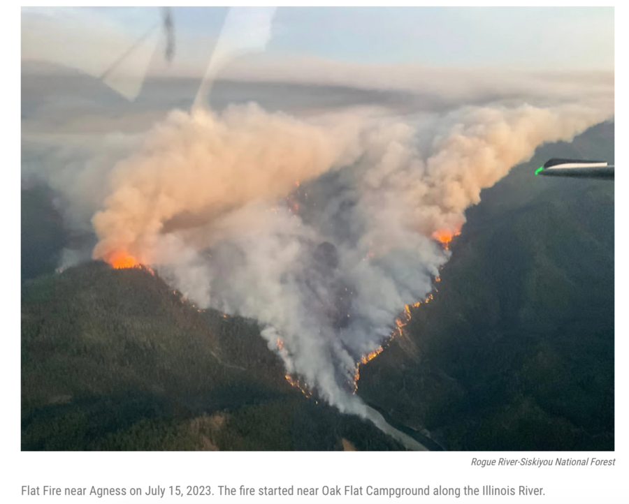
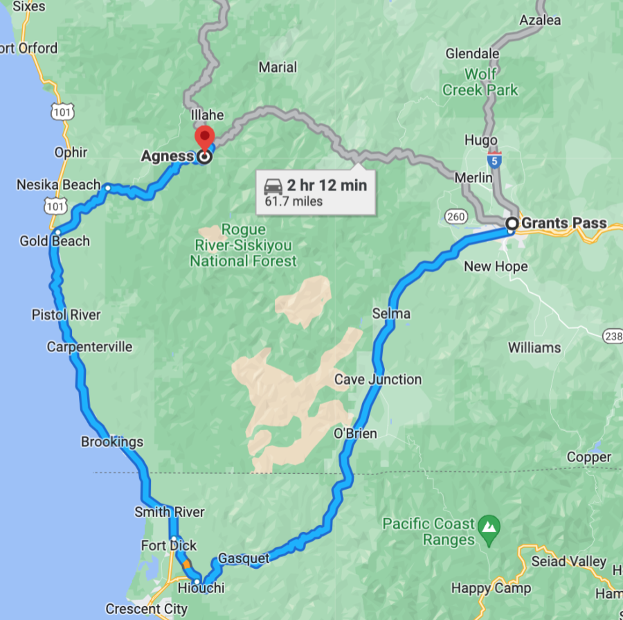
Oregon Public Broadcasting (OPB) reported that the Flat Fire is growing fast on the Rogue River–Siskiyou National Forest, between Gold Beach on Oregon’s south coast and Grants Pass on I-5. Weather conditions over the last couple days contributed to the quick spread, and an IMT took over from local agencies yesterday. The fire is burning just a couple miles from Agness, near the confluence of the Rogue River and the Illinois River.
The Rogue River flows 215 miles from Crater Lake to the Pacific Ocean. The 84-mile Congressionally-designated “National Wild and Scenic” portion of the Rogue begins 7 miles west of Grants Pass and ends 11 miles before its mouth at Gold Beach.

Jefferson Public Radio reported the fire grew more than 8,000 acres in under three days. Nearly 400 firefighters were working the fire, which threatens about 40 structures in and around the small community of Agness. On Monday, crews were building fireline to prevent further spread.
There’s a reason (or 4) that GoogleMaps will show you this “preferred route” and the “short route” between Grants Pass and Gold Beach; it’s really skatey even in the summertime, and LOTS of people get lost or stranded on Bear Camp Road. Please DO NOT interfere with firefighter vehicle traffic up there because you wanto “go get a look at the helicopters” or something … interfering with firefighting operations, whether you’re flying a drone or driving a pickup, will land you in jail, and some sheriffs are touchier about this than others.
It was planned yesterday that evening operations would include night crews on the northwest corner of the fire, if conditions permit, which would allow crews to burn out vegetation between fire crews and the active fire.
The fire recently was reported at just over 8,200 acres, with a total 378 personnel assigned to the incident. Resources at that time included 16 engines, 13 crews, 2 dozers, 7 helicopters, and 2 water tenders.
Closures: At least one closure order is in place for the safety of the public. Please be careful when driving in the area and do not drive toward the fire if you don’t live there or work there.
Restrictions: Fire restrictions are in place on the Rogue River–Siskiyou National Forest. The Forest has several closures and public use restrictions on the wild section of the Rogue River [HERE] but they’re mostly in pdf format and thus may not be accessible for everyone. Your best bet for mostly current info is inciweb. (Note the correct URL for this website has changed several times over the years, but for right now it is inciweb.nwcg.gov)– and even though the site warns you to redirect to inciweb.wildfire.gov, THAT DOES NOT WORK. The Flat Fire incident page doesn’t yet have any MAPS, but in the meantime here’s one of the general size of it, northeast of Gold Beach:

The Flat Fire is now the largest wildfire burning in Oregon and more crews and other resources are expected in the next few days; current management is under Albrecht’s Northwest Incident Management Team 6.
An evacuation shelter has been established at Gold Beach High School for anyone displaced by the fire and needing assistance. As of Monday, there were no evacuations ordered. Residents can sign up for emergency notifications with the Curry County Emergency Management Department.
There’s a small collection of outstanding photos online from the Coos Forest Protective Association. We expect more in the coming days.
KPIC-TV News reported that fire officials said the Flat Fire is burning in historic burn scars from both the 2002 Biscuit Fire and the 2018 Klondike Fire. Firefighters are working around numeroous standing dead trees and dense vegetation within these burn scars, and the landscape in this part of the Pacific Northwest is characterized by very steep terrain and extremely limited access options. Fire managers are deliberately considering firefighting tactics to keep crews safe, while protecting surrounding communities and infrastructure.
More resources arrived this morning, and their numbers will be boosted over the next several days. Crews are strengthening and building new firelines, and fire managers will assign aviation resources as conditions and visibility allow. Watch for updates from the 
Rogue Valley Interagency Community Center.
As of this morning there were no official closure orders for the area, but people are STRONGLY ADVISED TO STAY OUT. This is a rugged part of Oregon’s coastal mountains where people often get stranded or disoriented or lost, and local fire and law enforcement people don’t have a lot of spare time right now, with a fast-growing fire of this size, to come look for you. Stay out, and avoid getting in the way of firefighting operations. The rugged, mountainous terrain makes it more difficult for firefighting crews to access the area, BUT the Lost Coast Outpost reports that firefighters’ goal is “full suppression” on a rapidly growing fire in extreme summer temperatures.
Nationally, there are now eight fires being managed under a strategy other than full suppression. For updates on the Flat Fire, you can email 2023.flat.or@firenet.gov
No one was evacuated as of yesterday morning, Curry County Commissioner Brad Alcorn told the Lost Coast Outpost. But because of the steep and harsh terrain and hazardous weather conditions, Alcorn said he expects the fire will grow.
“There are a handful of residences up there, probably 14 to 15 homes, and the sheriff has contacted everyone,” Alcorn told the Outpost. “They’re in communication, so if there is a situation where we need to do an immediate evacuation we have a mechanism in place to make sure that happens safely.”
The Flat Fire was first reported at about 6 p.m. Saturday, Alcorn told the community in a video briefing on Sunday. It’s burning near Oak Flat, not far southwest of Agness, according to a Rogue River-Siskiyou National Forest news release on Sunday. The Forest Service said two days ago that about 40 structures were threatened. The fire is making its biggest gains in the Lawson Creek drainage; it’s on both sides of the Illinois River, burning in the 2002 Biscuit Fire scar.
The fire was mapped at 5,477 acres via an infrared flight two days ago, said Doug Epperson, the PIO for Northwest Incident Management Team 6, the Type 2 IMT that took over fire operations at 6 a.m. yesterday. He said the fire is burning in new regrowth that occurred after the 2002 Biscuit Fire.
“There’s been a lot of growth since then,” he added.

A red flag warning was in effect through this morning, and those weather conditions will likely contribute to additional fire spread. An air quality advisory was also issued for parts of Curry and Josephine counties; air quality could be diminished because of smoke from the fire. The National Preparedness Level is still at 2 and the national sit report lists just 16 large fires today.
Another firefighter has been killed during Canada’s worst wildfire season on record.
The firefighter from Fort Liard, a hamlet in the southwest corner of the Northwest Territories, died of an injury he sustained while fighting a fire in the Fort Liard district on Saturday. The globalnews.ca reported that the Government of the Northwest Territories did not identify the firefighter, but confirmed that his family, the RCMP, and the Coroner Service were notified.
The Journal of Commerce reported that Fort Liard Mayor Genevieve McLeod said word began circulating in the community late Saturday afternoon that there had been an accident. At first, it was only thought that someone had been hurt, and there was no word who it was.
“A big part of the community went to the airport to meet the helicopter,” McLeod said in a phone interview. “They brought the individuals in from the forest fire they were fighting and that’s when everyone found out.”
McLeod, too, didn’t want to identify the firefighter who died, noting he had a large family and that some, who lived in the south, might not have yet heard the devastating news.
“He was a big part of our community — young and hard working. He has a young family,” she said.
“Our thoughts are with his family, friends, colleagues and community,” wrote fire information officer Jessica Davey-Quantick. “We share your deep sorrow at this loss, and we send our deepest condolences to all those affected by this tragedy, including wildfire personnel who are committed to protecting their communities and the residents of the NWT.” There are at least three wildfires burning near Fort Liard, about 37 kilometres (23 miles) north of the B.C. border.
On Sunday NWT Premier Caroline Cochrane said she was deeply saddened by the loss of life sustained while protecting the territory, and she thanked the man for his service. “This is a tragic loss for the entire territory, and I extend my heartfelt condolences to their family, friends and colleagues.”
As of yesterday, according to the ctvnews.ca, the danger level was considered “extreme” for fires in the Fort Liard area. Currently, there are 89 active fires burning across the Northwest Territories, including one new fire that started in the last 24 hours. More than 809,000 hectares are affected by the fires in that territory.
UPDATE 07/20/2023: WILDLAND FIREFIGHTER Magazine reported that Firefighter Adam Yeadon, 25, from Fort Liard was a member of the Acho Dene Koe band.
