Roosevelt Fire in western Wyoming grows to over 31,000 acres

One structure burned Wednesday night

(UPDATED at 4:31 MDT Sept. 20, 2018)

The 31,681-acre Roosevelt fire continued to burn aggressively into Wednesday night 30 miles south of Jackson, Wyoming. Most of the growth was on the south and east sides according to mapping conducted during the night. The fire is three miles from Highway 191 and six miles south of Bondurant.

Windy conditions Wednesday afternoon resulted in  numerous crown fire runs and occasional extreme rates of spread and flame lengths. One structure burned Wednesday night, but it was not specified if it was an outbuilding or residence.
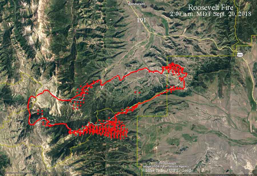
map Roosevelt Fire Wyoming
The red line was the perimeter of the Roosevelt Fire at 10:30 p.m. MDT September 19, 2018. The white line was the perimeter about 24 hours before. The red dots represent heat detected by a satellite at 2:40 a.m. MDT September 20.

Additional resources continue to arrive to assist the existing 259 personnel already on scene.

To see the all of the articles about the Roosevelt Fire on Wildfire Today, including the most recent, click HERE.

A Red Flag Warning is in effect Wednesday for relative humidity below 15 percent and afternoon winds from the west at 15 mph, gusting to 25 mph.

A update issued by the Incident Management Team September 20 stated “no injuries have occurred”. However on September 16 the Jackson Hole News & Guide reported that two civilians were seriously injured:

…They were caught in the area and forced to retreat into a creek. They were transported to St. John’s Medical Center, and as of Sunday night were being transferred to a burn center in Salt Lake City, according to a press release [Denise] Germann sent.

Ms. Germann was providing information about the fire for Grand Teton National Park and the Bridger-Teton National Forest.

When asked about injuries on the fire, Lorisa, a spokesperson for the Roosevelt Fire, said they are only reporting injuries that have occurred since the Incident Management Team presently in charge has been at the fire.

Thanks and a tip of the hat go out to Allen.
Typos or errors, report them HERE.

Most of U.S. predicted to have above normal temperatures the rest of the year

Posted on Categories UncategorizedTags

temperature precipitation outlook

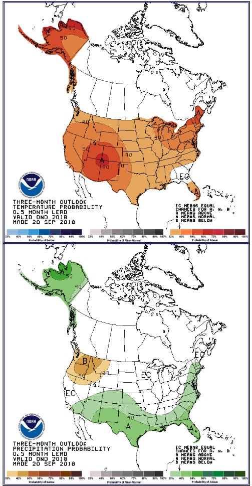
Today the National Weather service issued their long range temperature and precipitation outlooks for October through December. If their forecast is correct almost all of the United States is likely to have higher than normal temperatures the rest of this year. The precipitation outlook is more varied, with the Northwest expecting below normal amounts, while the Southwest, Southern Plains, the Gulf Coast and East Coast should receive above normal precip.


Four senators urge federal officials to publish fire training materials in Spanish

Incident Response Pocket GuideOn Tuesday four U.S. Senators signed a letter urging federal officials to resume publication of wildfire training materials in Spanish as well as English.

The letter from Senators Ron Wyden, Jeff Merkley, Dianne Feinstein, and Kamala Harris follows a report that the National Wildfire Coordinating Group no longer publishes training materials in Spanish for wildland fire crews.

“Given that a significant number of these brave wildland fire crews speak Spanish as their native language, it would be wiser and safer to provide bilingual training materials,” the senators wrote in their letter to National Wildfire Coordinating Group Chairman Garth Fisher. “The alternative is to risk danger and harm by requiring that all firefighters rapidly attempt to understand training materials that are only available in English.”

The senators urged the NWCG to begin producing bilingual versions of key manuals like the Incident Response Pocket Guide.

“Firefighters must be provided with clearly understandable, updated training materials so that they can operate safely and respond to wildfires expeditiously and efficiently,” the senators wrote.


USPS honors first responders with a stamp

Posted on Categories Uncategorized
First Responders Stamp

The U.S. Postal Service went to the Aerial Fire Depot and Smokejumper Center in Missoula, MT on September 13 for the first-day-of-issue ceremony for a stamp that honors first responders.

“Our nation’s first responders rush into life-threatening situations for the benefit of others,” said Guy Cottrell, the Postal Inspection Service’s Chief Postal Inspector and dedicating official. “The Postal Service is pleased to honor their skill, dedication and unfailing bravery with this stamp.”

Artist Brian Stauffer worked with art director and designer Antonio Alcalá and designer Ricky Altizer to create this stamp. As a contributing artist to The New York TimesTime magazine, The New Yorker and other publications worldwide, Stauffer’s illustrations are best known for bridging traditional and digital realms to create a conceptual take on social issues.


Our take:

It is wonderful that the Postal Service is honoring first responders. They don’t receive enough credit and recognition. Congrats, USPS. However, I doubt if the Postal Service personnel saw anyone at the smokejumper base outfitted like the folks on the stamp.

By the way if you have not bought any stamps lately, these babies will set you back $0.50.

Google Earth acquires imagery of Thomas Fire

Google Earth, the software that has aerial imagery from all over the world, now has satellite photos of the Thomas Fire. The photo above is from December 13, 2017. To see the fire images you will need to zoom in fairly close and select imagery from December, 2017 (View/Historical Imagery). The photos are from December 4 through 18, 2017.

The Thomas Fire burned 281,893 acres in December, 2017 near Ventura, California, making it for a surprisingly short time, the largest wildfire in recent California history. It destroyed 1,063 structures, damaged 280 more, and set in motion the factors that led to a series of flash-floods and landslides that killed 21 residents. Seven months later the Ranch Fire east of Ukiah became the largest in the recent history of the state, burning 410,000 acres.

Thanks and a tip of the hat go out to Robert.
Typos or errors, report them HERE.

Two fires south of Jackson, Wyoming spreading rapidly at high elevation

The Roosevelt and Marten Creek Fires are 30 and 50 miles south of Jackson

Above: The Martin Fire, September 16, 2018. InciWeb.

(UPDATED at 7:02 a.m. MDT September 19, 2018)

The Roosevelt Fire 30 air miles south of Jackson, Wyoming was very active Tuesday growing to within 3 miles of Highway 191. Since it started September 15 it has spread 16 miles to the east. When it was mapped at 10:45 p.m. Tuesday the fire was 6 miles south of Bondurant. Most of the blaze at that time was within the Bridger-Teton National Forest but began to move onto private land on the east side near Muddy Creek Road late in the day.

To see the all of the articles about the Roosevelt Fire on Wildfire Today, including the most recent, click HERE.

The mapping flight Tuesday night determined the fire had burned approximately 25,168 acres, which was almost three times the size we estimated it had burned at 2:59 p.m. Tuesday.

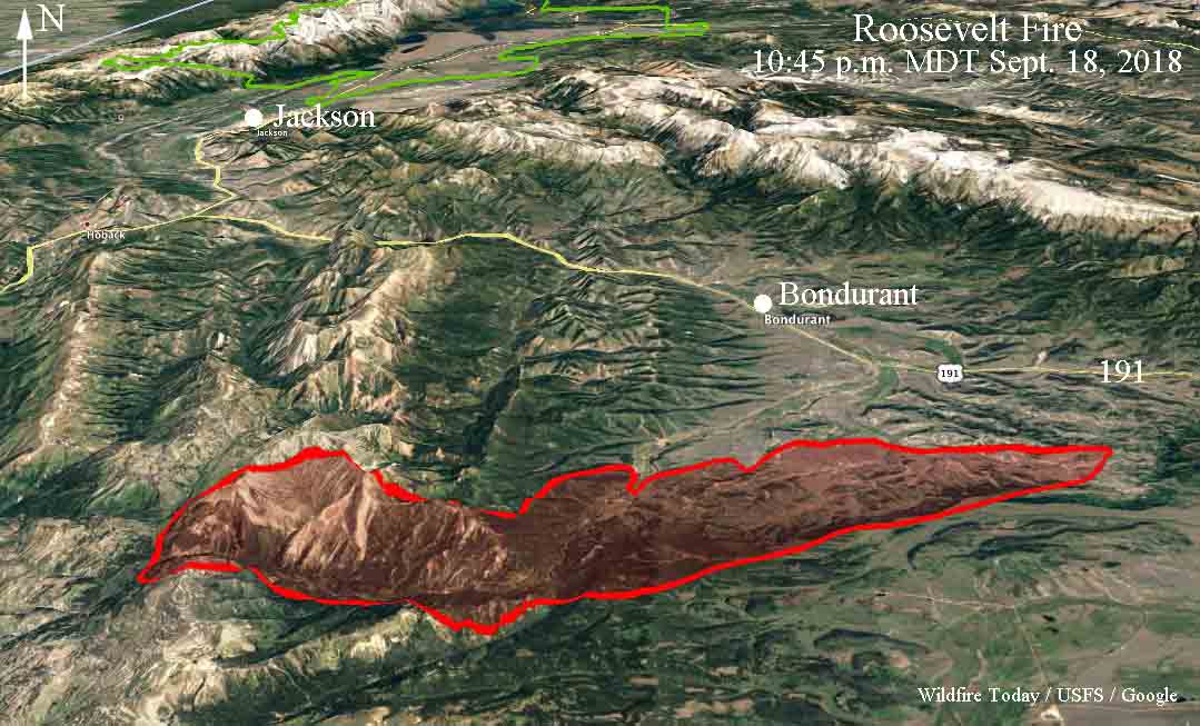
3-D map Roosevelt Fire Wyoming
3-D map, looking north, showing the perimeter of the Roosevelt Fire at 10:45 p.m. MDT September 18, 2018.
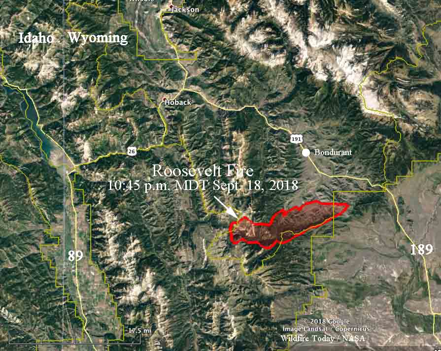
map Roosevelt Fire Wyoming
Map showing the perimeter of the Roosevelt Fire at 10:45 p.m. MDT September 18, 2018.

The Marten Creek Fire 50 miles south of Jackson was much less active Tuesday afternoon and evening.


(Originally published at 9:38 p.m. MDT September 18, 2018)

It is not every year that in mid-September we see wildfires south of Jackson, Wyoming spreading rapidly at 7,000 to 10,000 feet above sea level.

The Roosevelt Fire started September 15 about 30 air miles south of Jackson and spread to the east over a 10,000-foot ridge. At about 3 p.m. Tuesday it had spread along the east slope back down to 7,000 feet, 7  miles south of Bondurant.

The Great Basin Incident Management Team 6 led by Incident Commander Jeff Knudson will assume command of the fire Tuesday at 6:00 p.m.

Fire officials said it is a full suppression fire “utilizing natural barriers. These barriers will aid in slowing the fire growth. In other areas that are safe to have firefighters working direct, we will be using that tactic.”

The Sublette County Sheriff’s Office has issued Evacuation Orders for several areas. Their Facebook page has the latest official information.

Our very UNOFFICIAL estimate of the size of the Roosevelt Fire, based on heat detected by a satellite flying 200 miles overhead at 2:59 p.m. MDT September 18 puts it about 9,000 acres.

The Marten Creek Fire started near Gray River Road September 16, about 50 miles south of Jackson and has also worked its way up to a 10,000-foot ridge. It is 12 miles east of Afton, Wyoming. Strong winds aligned with the topography significantly increased the fire behavior Monday and Tuesday.

Tuesday evening a Type 2 Incident Management Team will begin transitioning with the local Type 3 team, in association with the U.S. Forest Service. The fire was human caused and is currently under investigation. Fire officials said Tuesday night the fire has burned about 5,700 acres.

The area will be under a Red Flag Warning Wednesday. The forecast for the fire area calls for a high of 70 degrees at 7,800 feet, winds out of the southwest at 15 mph gusting to 23, and relative humidity in the low teens.