The National Interagency Fire Center embedded this video in a tweet on August 17, titled “Week in Wildfire”. It is not dated, but apparently covers the week beginning August 12, 2018.
Firefighters, support personnel and military and national guard soldiers continue to work on wildfires across the country. Here’s a look at this Week in Wildfire. Credit: NIFC, Inciweb #PL5#WeekinWildfirepic.twitter.com/grQIC0tOs4
Two fire vehicles fighting the North Eden Wildfire were destroyed August 17 by wind-driven flames. A heavy engine from Woodruff Fire Department and a light engine from the State Division of Forestry Fire & State Lands responded to the fire’s west flank.
One engine experienced a mechanical problem and as both crews tried to make the vehicle mobile again flames quickly moved toward the scene cutting off their escape route. The group of three firefighters was forced to leave the vehicles and escape into the black. No injuries were reported.
The fire is on the north end of Lake McDonald north of West Glacier, Montana
Above: The Howe Ridge Fire at the north end of Lake McDonald, August 12, 2018. NPS photo.
(Originally published at noon August 16, 2018)
The Howe Ridge Fire in Glacier National Park has burned 3,500 acres at the north end of Lake McDonald 8 miles north of West Glacier, Montana. It started August 11 from a lightning strike and is being “managed”, or herded around, rather than being fully suppressed. The 78 personnel assigned to the fire are protecting structures and utilizing water drops from air tankers and helicopters to slow the spread where needed. However on Wednesday fixed wing aircraft were grounded due to heavy smoke.
Structural protection crews worked Wednesday to reduce risk to buildings at the head of Lake McDonald and Kelly’s Camp.
The time-lapse video of the fire below is very impressive:
The Southwest Area Type 1 Incident Management Team, under the command of John Pierson, is onsite and will be taking over management of the fire at 6:00 a.m. Friday. Mr. Pierson’s team is also managing two other fires, the Paola Ridge and Coal Ridge fires.
Map showing the perimeter of the Howe Ridge Fire based on a mapping flight at 10:30 p.m. MDT August 15, 2018.
Area closures and evacuations remain in place. The Going-to-the-Sun Road remains open between St. Mary and Logan Pass. It is closed between the foot of Lake McDonald (near Apgar) and Logan Pass. Apgar Village, Apgar Campground and Fish Creek campground remain open. Most other areas of the park are open.
Howe Ridge Fire, August 12, 2018. NPS photo.Water scooping air tankers work the Howe Ridge Fire in Glacier National Park. Undated NPS photo.
Above: On August 12 firefighters initiated burnouts as they constructed fireline. This can remove unburned vegetation between the line and the fire. Photo by William Ing.
With the heavy rain that hit the Hot Springs, South Dakota area Wednesday the threat from the Vineyard Fire has greatly diminished, with residents reporting around an inch of precipitation. On Tuesday the firefighters stopped providing updates on the Facebook page created for the fire and an entry was never made on InciWeb — indications that the firefighting activities have slowed.
But rain can’t completely extinguish a wildfire that involves timber. Roots can smolder underground for weeks or months and burning logs don’t always go out by simply applying water from above.
Map of the Vineyard Fire.
According to the last official update from Great Plains Fire Information on August 14 the fire had burned 560 acres, all evacuations had been lifted, and the cause was still under investigation.
William Ing took these photos on August 11 and 12 from Butler Park and the Dairy Queen in Hot Springs. Thanks William!
An Air National Guard Blackhawk helicopter drops water adjacent to onlooking firefighters (lower right).
These “Firewatch Cobras” have infrared sensors that can detect heat from fires. There is video in the article in which the pilot directs firefighters on the ground to a hot spot near the line on the Jesusita fire near Santa Barbara on May 12, 2009. The heat source is so small that the firefighters walked past it and over it several times, but the pilot could easily see it using the infrared equipment.
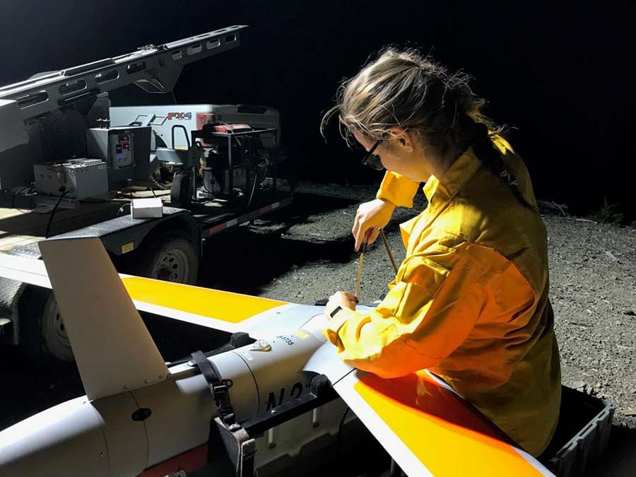
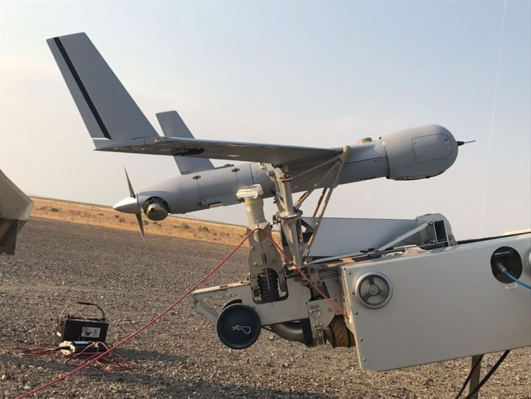
That video was filmed during daylight hours. Eight years later we now have the ability to have an unmanned aerial vehicle with sophisticated sensors orbit continuously over a fire, day and night, for 18 to 20 hours depending on the weight of its payload. If an incident management team on a fire activates a couple of these using the recently awarded Call When Needed contract, firefighters can have greatly enhanced situational awareness with near real time video.
Insitu was one of four companies that won CWN contracts in May. On the Taylor Fire in southwest Oregon on August 5, firefighters requested that the company’s ScanEagle aircraft monitor an overnight burn operation they were conducting along a ridge top road. As it orbited in the darkness at 8,500 feet, the sensors and the pilot detected a spot fire about 100 feet outside the fireline in the “green” unburned area.
The pilot talked directly with firefighters in an engine, telling them where it was.
Engine 66 stop there, spot fire is out your passenger door, 100 feet.
As you can see in the video below, the firefighters, it looked like at least three of them, searched the area and found the spot fire, which they said was about one foot square.
Depending on your taste in music, you will either want to turn up the sound in the video, or turn it off. I doubt if there’s any middle ground. There is no narration, so you won’t miss anything with the sound off.
The ScanEagle was launched from and recovered within the Temporary Flight Restriction over the fire. It was flown beyond visual line of sight in accordance with the 2015 FAA/Department of the Interior Memorandum of Understanding.
We have often written about the Holy Grail of Wildland Firefighter Safety — knowing in real time the location of the fire and the location of personnel. Many assumed the location of the fire would be the most difficult obstacle to overcome. But apparently the technology, suitable and practical enough to be used on a wildfire, is on a CWN contract. BOOM!
The location of firefighters can also be solved. The technology exists now. Many agencies are using various systems, especially metropolitan law enforcement and fire organizations, but the federal land management agencies and most of the larger state fire organizations are dragging their feet. Earlier this year CAL FIRE took a step in the right direction when they issued a contract to provide technology in 1,200 state-owned vehicles that will facilitate mission critical data communications over a variety of networks (broadband, narrowband and satellite). This will include tracking the location of firefighting vehicles, but probably not dismounted personnel.
Complex terrain is one of the difficulties in continuously tracking the location of resources on a wildland fire, but there are ways to get around this, including putting radio repeaters in drones, perhaps the same one that is tracking the fire.
One of these days, drones will be on automatic dispatch along with engines, crews, and other aircraft. I know — a lot of deconflicting of aircraft has to be worked out, but it WILL happen.
The map above shows the prediction for the distribution of wildfire smoke at 6 p.m. MDT August 14, 2018. It looks like it is going to be pretty rough today in Washington, Oregon, Idaho, Montana, Wyoming, and parts of Northern California.