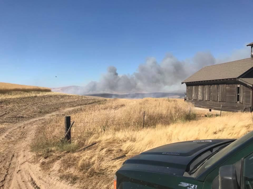
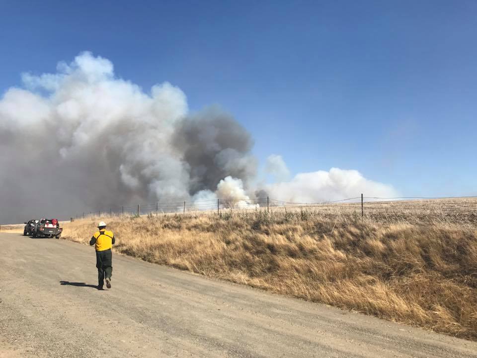
Ferguson Fire spreads north across Merced River

By Saturday night the fire had burned over 30,000 acres.

(UPDATED at 4:19 a.m. PDT July 22, 2018)

Friday night and Saturday the Ferguson Fire west of Yosemite National Park in California grew by more than 3,300 acres to bring the total to about 30,400 acres.  Most of the activity was on the north flank where it jumped across Highway 140 and the Merced River Friday afternoon but the fire also ate up additional acreage on the southeast side. Firefighters engaged the slop over across the river early Saturday but were unable to make headway in the steep, rugged terrain.

map Ferguson Fire July 22, 2018
Map showing the Ferguson Fire, mapped at 11 p.m. PDT July 21, 2018. The red shaded areas represent intense heat at that time, while the yellow line was the perimeter about 24 hours before. Click to enlarge.

Again Saturday the inversion trapped smoke, decreasing visibility and making it a challenge to use aircraft. The inversion also slows the fire, reducing solar heating of the fuels and preventing strong winds which can be the most important factor affecting the rate of spread. When the smoke cleared in the afternoon fire activity increased, which has been the pattern for the last several days.

CLICK HERE to see all of the articles on Wildfire Today about the Ferguson Fire, including the most recent.


(UPDATED at 4:25 p.m. PDT July 21, 2018)

The Mariposa County Sheriff’s Office issued additional mandatory evacuation orders Saturday for the Ferguson Fire west of Yosemite National Park in California.

  • Anderson Valley Area — northwest of the El Portal Area. At this time there are no Evacuation Orders or Advisements in the Greeley Hill or Coulterville Communities.
  • Yosemite West

On the map below, click on the circles to see more information.


(Originally published at 7:24 PDT July 21, 2018)

At about 3 p.m. PDT Friday afternoon two spot fires occurred on the Ferguson Fire west of Yosemite National Park in California. These “slop overs” were on the north side of Highway 140 and the Merced River on a large dog leg near Miller Gulch and Ned Gulch in an area that was too steep and rugged for fixed wing air tankers.

map Ferguson Fire
Map showing the Ferguson Fire, mapped at 9:30 p.m. PDT July 20, 2018. The red shaded areas represent intense heat at that time, while the yellow line was the perimeter about 23 hours before. Click to enlarge.

While helicopters and hand crews attacked the spot fires near the river, air tankers painted the upper slopes with retardant. Firefighters on other parts of the fire and additional resources from outside the fire were assigned to suppress this new threat. But when a mapping aircraft flew over at 9:30 p.m. 2,000 acres had become established across the river.

This slop over and other growth on the fire brought the total size up to 27,129 acres according to fire officials, an increase of more than 4,000 acres from the day before.

3-D map Ferguson Fire
3-D map, looking north, showing the 2,000-acre slop over on the Ferguson Fire, mapped at 9:30 p.m. PDT July 20, 2018. The red shaded areas represent intense heat at that time, while the yellow line was the perimeter about 23 hours before. Click to enlarge.

This prompted a mandatory evacuation order from the Mariposa County Sheriff’s Office for Rancheria Government Housing, Old El Portal, Yosemite View Lodge, and Foresta.

The spot fires were across the Merced River and north of Ferguson Ridge which forms a large mile-wide dog leg in the river. On the west side of the dog leg the fire had been tied in with the highway, but from the maps we have seen it appeared that about two miles of the fire edge on the east side of the dog leg were about a third of a mile from the river. (Note the yellow line on the map above that represents the fire edge Thursday night.)

Until Friday, firefighters on the Ferguson Fire had been able keep the fire south of the highway and the river. This is a whole new ball game for the incident management team. In crossing the river the fire spread from the Sierra National Forest into the Stanislaus National Forest in an area that is very steep with difficult access. Friday night the slop over was about four miles from Yosemite National Park burning in a major drainage leading to the park boundary. A mile or two beyond that — Highway 120, Tioga Road, and Big Oak Flat Road.

Other areas on the fire were also active Friday, with most of the additional growth being on the south and east sides. Crews continued to make progress building line along the southwest and western edges of the fire near Jerseydale and Mariposa Pines.

Yosemite National Park is open, but very smoky.

Ferguson Fire claims more acreage on west, south, and east sides

The fire near Yosemite National Park grew by over 5,000 acres during the last two days

(Above: Ferguson Fire photo uploaded to InciWeb around July 18, 2018)

(Originally published at 3:24 p.m. MDT July 20, 2018)

The Ferguson Fire that has been burning since July 13 has become almost predictable over the last three or four days, adding a few thousand acres each day. Since we last wrote about this fire two days ago west of Yosemite National Park in California it has added about 5,500 acres, again on the west, south, and east sides bringing the total up to 22,892 acres. So far firefighters have been mostly successful in keeping the north side of the fire from crossing Highway 140, one of the several routes into the Park. The highway has been closed from El Portal Road to 1.5 miles West of Midpines for several days.

CLICK HERE to see all of the articles on Wildfire Today about the Ferguson Fire, including the most recent.

Map perimeter Ferguson Fire
Map showing the Ferguson Fire, mapped at 10:15 p.m. PDT July 19, 2018. The red shaded areas represent intense heat at that time, while the yellow line was the perimeter two days before. Click to enlarge.

About half a dozen areas are under mandatory evacuation orders, primarily on the north and west sides of the blaze. Other areas have been warned that they may have to evacuate on short notice.

On Thursday firefighters worked on the primary containment line on the west side of the fire along Henness Ridge which should be complete by the end of the day on Friday. Firefighters working on indirect lines (built away from the fire’s active edge) around the community of Jerseydale also made good progress Thursday.

As of Friday morning no structures have been damaged or destroyed.

Yosemite National Park remains open, but often the smoke is very dense. For information about the park, go to: nps.gov/yose or call 209-372-0200.

Earlier today we posted a map that shows the distribution of wildfire smoke in the United States.

Wildfire smoke forecast, July 20, 2018

This is a prediction for the distribution of smoke from active wildfires for 6 p.m. MDT July 20, 2018. If correct, the areas that will be inundated with heavy smoke will include portions of Northern California, Southern Oregon, and Northern Nevada.

Much of the smoke is coming from the lightning fires in Southwest Oregon, the Boylston Fire in Central Oregon, and the Ferguson Fire near Yosemite National Park in California. The Lake Christine Fire which has been burning for weeks in Colorado is also a smoke contributor.

United States and Canada share firefighting resources

Above: Saskatchewan air tanker 474 lands at Medford, Oregon July 19, 2018.

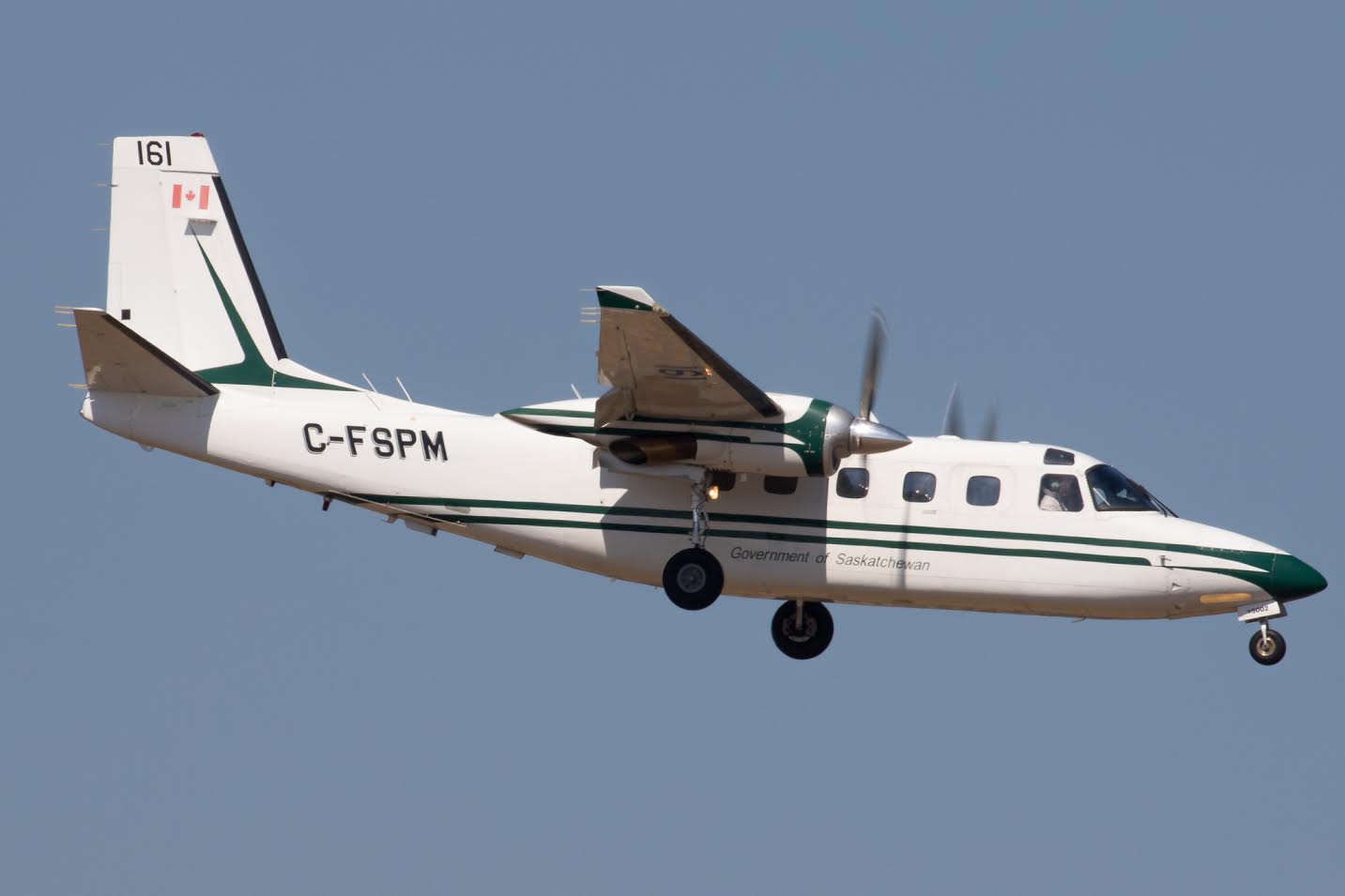
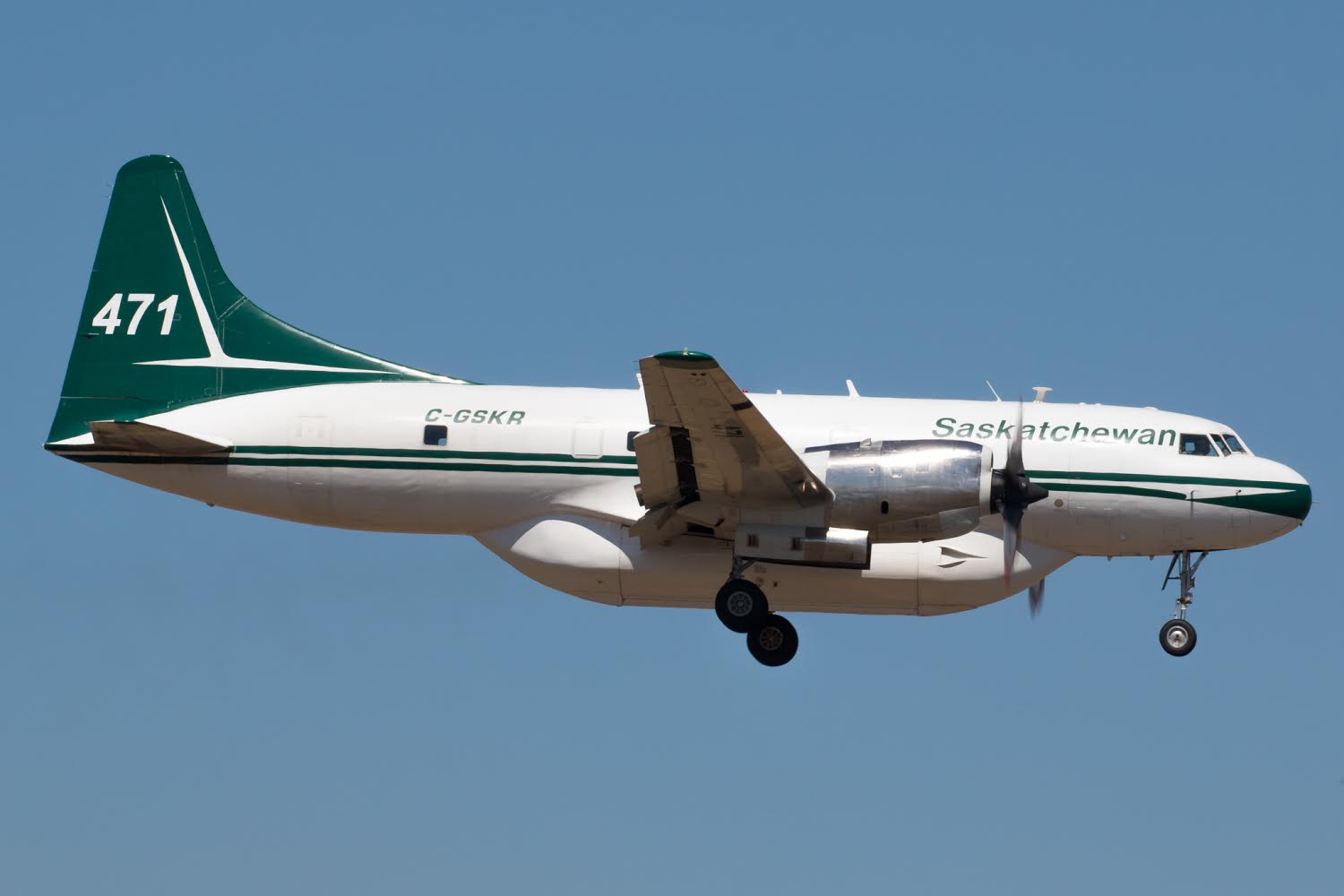
Tim Crippin shot these photos of firefighting aircraft arriving at the Medford, Oregon airport July 19. The two air tankers and the Bird Dog aircraft are owned by the government of Saskatchewan. The planes were mobilized through the Pacific Northwest Compact to Oregon; it was not an action that was taken by the National Interagency Coordination Center (NICC).

Saskatchewan Bird Dog 161
Saskatchewan Bird Dog 161 lands at Medford July 19, 2018.

The Canadians use “Bird Dog” aircraft in a role similar to lead planes in the United States. A Bird Dog usually works with two air tankers as a three-aircraft module. This one, 161, is an Aero Commander 690D.

Saskatchewan air tanker 471
Saskatchewan air tanker 471 lands at Medford, Oregon July 19, 2018

In addition to these three aircraft, other firefighting resources have been flowing across the international boundary in recent weeks from the U.S. to Canada:

  • NICC dispatched 12 wildland federal firefighters to Ontario, Canada.
  • The Northeast Compact sent resources to Ontario including three Type 2IA crews from New Hampshire, Maine and Massachusetts. However, the New Hampshire and Maine crews were demobed earlier this week and the Massachusetts crew will be demobed on Sunday.
  • Maine will be sending a second Type 2 IA crew to Ontario on Saturday.
  • The Great Lakes Compact has sent to Ontario 10 single resources (2 aviation managers and eight firefighters).
  • Wisconsin State will be mobilizing eight firefighters also to Ontario, Canada.

No aircraft have been sent to Canada from the U.S.

Boylston Fire in Washington grows to 70,000 acres overnight

On Friday the eastbound lanes of Interstate 90 were closed

Above: Photo of the Boylston Fire taken by the Washington DNR Ahtanum crew when they were evacuating the Wanapum recreational area Thursday night.

(Originally published at 10:08 a.m. PDT July 20, 2018)

A very rapidly spreading wildfire in Washington forced the closure Friday of the eastbound lanes of Interstate 90 east of Kittitas in the area of milepost 122. The Boylston Fire was reported late in the afternoon Thursday July 19 and by 10 a.m. Friday fire officials estimated it had grown to 70,000 acres.

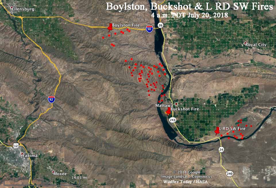
The fire is burning mostly south of Interstate 90 between Ellensburg and Mattawa. It apparently started near the Interstate and spread southeast about 13 miles to the Columbia River.

map Boylston Fire Washington
The red dots represent heat on the Boylston, L RD SW, and Buckshot Fires detected by a satellite at 4 a.m. PDT July 20, 2018. It is likely that in some areas with light fuels, such as grass, the fire could have burned and cooled in between satellite overflights, and therefore was not detected in those areas. Click to enlarge.

Some areas on the Boylston Fire are difficult for ground crews to access.

A Type 2 Incident Management Team is en route.

The Red Flag Warning for the area on Friday will not give firefighters a break. The forecast calls for relative humidity of 12 to 25 percent and winds out of the west at 10 to 20 mph gusting to 25.

Red Flag Warning, July 20, 2018
Red Flag Warning, July 20, 2018.

There are two other smaller fires in the same general area, southeast of the Boylston Fire. The Buckshot Fire is on the east side of the Columbia River southwest of Mattawa. A fire with an unfortunate name, the “L RD SW Fire” is farther east near the intersection of Highways 24 and 243, and is also near the river.

These three fires are 27 to 36 miles northeast of Yakima, Washington.

Regarding the Tweet below, at 10 a.m. PDT Friday, fire officials estimated the Boylston Fire had burned 70,000 acres.

One dead, 50,000 acres burn in Substation Fire

Northern Oregon southeast of The Dalles

Above: Substation Fire. Incident Management Team photo, July 18, 2018.

(Originally published at 6:33 a.m. PDT July 19, 2018)

Since the Substation Fire started July 17 southeast of The Dalles, Oregon it has claimed the life of one person and burned over 50,000 acres. The fire has blackened an area approximately 18 miles long by 8 miles wide, and has jumped the Lower Deschutes River in at least two places.

The Wasco County Sheriff’s Office reported that at 1:30 p.m. on July 18 deputies answered a call about a burnt tractor. They found the operator a short distance away, deceased, apparently killed by exposure to the fire. The operator may have been attempting to suppress the fire by using the tractor and disk to construct a fireline. The release of the person’s name is pending notification of next of kin.

The Sheriff’s Office has the most current information about the areas under evacuation orders. They have boats patrolling the river to notify hikers and boaters.

Officials have closed Highway 97 from Biggs Junction to Highway 197.

The Governor declared the fire a conflagration Wednesday, which allows the state fire marshal to mobilize firefighting resources.

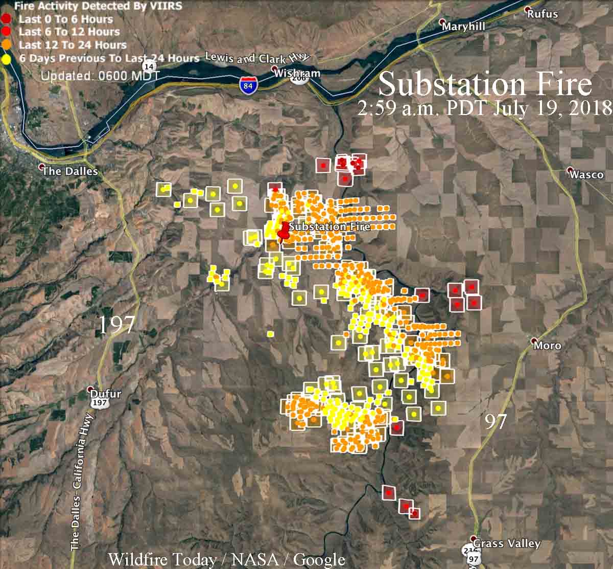
map substation fire
Map showing heat on the Substation Fire detected by satellites as late as 2:59 a.m. PDT July 19, 2018. The red icons are the most current. It is likely that in some areas light fuels such as wheat and grass burned and cooled in between satellite overflights, therefore was not detected by the sensors. Click to enlarge.

The area is under a Red Flag Warning on Thursday. The forecast for the fire area calls for 78 degrees, 25 percent relative humidity, and afternoon winds out of the northwest of 19 gusting to 27 — not good news for firefighters.

A Type 1 Incident Management Team (Schulte) has been assigned to the fire.

One structure has been destroyed, an often photographed historic home.

Substation Fire
Substation Fire. Incident Management Team photo, July 18, 2018.
Substation Fire
Substation Fire. Incident Management Team photo, July 18, 2018.

The video below was uploaded by the Incident Management Team to Facebook on July 18, 2018.