Lessons learned by fleet manager during major wildfire siege

The vehicle fleet in Sonoma County was heavily impacted by the Tubbs, Nuns, and Pocket Fires in October, 2017

Above: Tubbs Fire in Sonoma County, California, October, 2017. Photo by Jeff Zimmerman.

The huge fires that tore through populated areas north of the San Francisco Bay Area last October heavily impacted the region. The Nuns, Pocket, Atlas, and Tubbs Fires in Sonoma and Napa Counties burned over 100,000 acres. At least 44 people were killed and more than 5,000 structures were destroyed after the siege began October 8.

Facts like the above are what you normally hear when the impacts of wildfires and other natural disasters are discussed. But a lot is going on behind the scenes to directly or indirectly mitigate the effects and provide logistical support for the emergency responders.

Three fires burned in Sonoma County — the Pocket, Tubbs, and Nuns Fires. The county is very large — 1,768 square miles with a population of half a million.
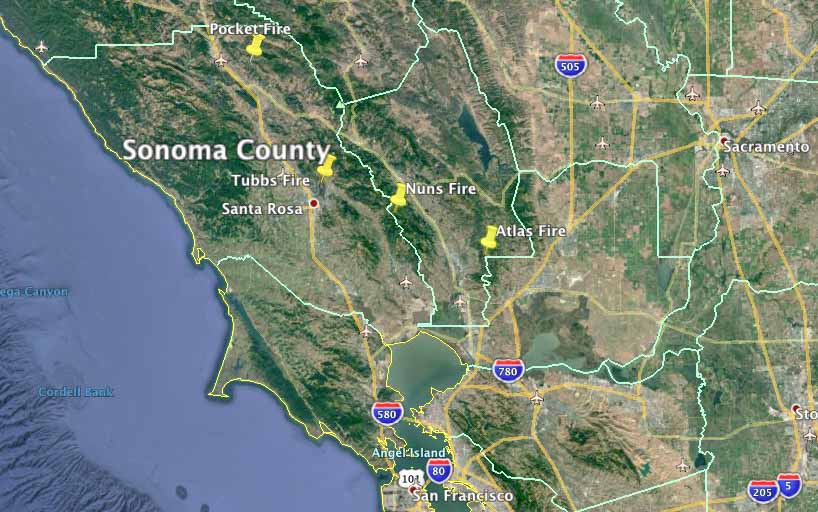
Sonoma County wildfires map
Map showing the locations of fires in and near Sonoma County, California. Wildfire Today/Google. County borders are in light green.

The County-owned vehicles are maintained by fleet manager David Worthington and his 22 colleagues. In an article published at Government Fleet, Mr. Worthington wrote about some of the lessons his organization learned during the fire siege. Many Logistics personnel on Incident Management Teams are familiar with some of these issues, but it is interesting hearing about the perceptions of a fleet manager outside of the wildfire organization.
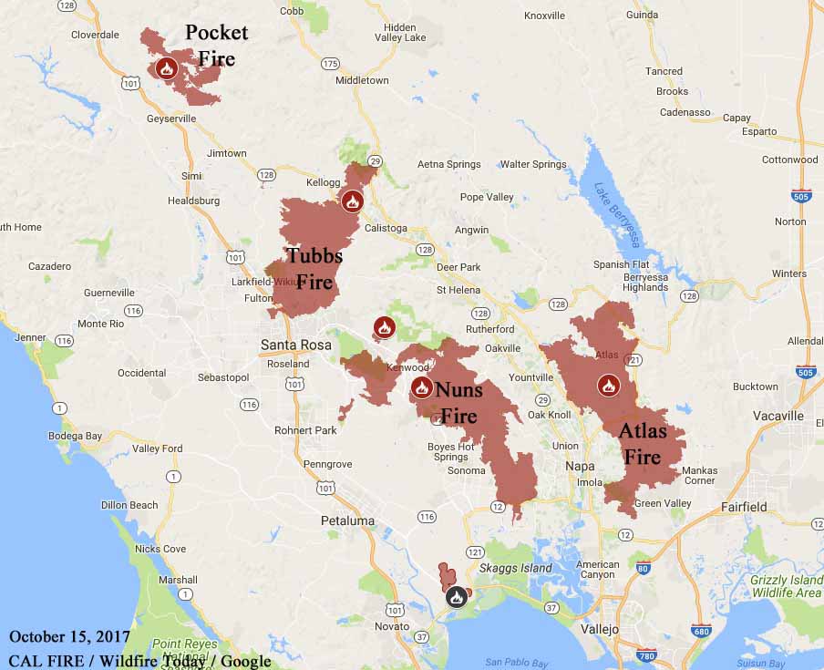
map Pocket, Tubbs, Nuns, and Atlas
Map showing the perimeters of the Pocket, Tubbs, Nuns, and Atlas Fires. CAL FIRE October 15, 2017.

You should read the entire article, but here are some of the topics that were covered in the article.

  • Many tires on Deputy Sheriff vehicles had flats caused by driving over debris and then in some cases were destroyed when the officer had to continue driving to get to a safe place to stop.
  • Several vehicles suffered significant damage from radiant heat — melted plastic trim, headlights, and damage to the vinyl layer in the window glass.
  • With a high demand for fuel, they stopped trying to schedule fuel deliveries, and had the vendors bring a truck every day to top off the storage tanks.
  • Replacing the plugged cabin air filters was as important as replacing the engine air filters.

Sonoma County fire damaged vehicle
Several County of Sonoma vehicles sustained major damage from radiant heat. Photo credit: Sonoma County.
Sonoma County fire damaged vehicle
Several County of Sonoma vehicles sustained major damage from radiant heat. This shows damage to plastic and the vinyl layer in the window glass. Credit: Sonoma County.

Thanks and a tip of the hat go out to Bob.
Typos or errors, report them HERE.

Red Flag Warnings in six states, April 4, 2018

The National Weather Service has issued Red Flag Warnings for areas in Colorado, Kansas, New Mexico, Oklahoma, Texas, and Nebraska.

The Red Flag Warning map was current as of 7:45 a.m. MDT on Wednesday. Red Flag Warnings can change throughout the day as the National Weather Service offices around the country update and revise their forecasts.

Waterborne Hotshots

Above: USFS photo.

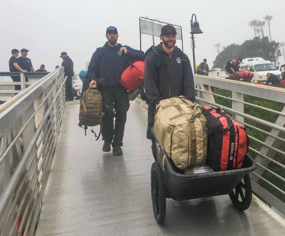
When 10 members of the Sierra Hotshots travelled to the fire on Santa Cruz Island 20 miles off the Southern California coast March 28, the last leg of their journey was on a boat.

The fire started March 27 most likely from an escaped burn pile and at last report on April 2 it had burned 250 acres. On March 29 there were 95 firefighters assigned from California and Arizona but that number has been reduced significantly.

Sierra Hotshots boat Santa Cruz fire
10 members of the Sierra Hotshots en route to the Santa Cruz Fire. USFS photo.
Sierra Hotshots boat Santa Cruz fire
10 members of the Sierra Hotshots en route to the Santa Cruz Fire. USFS photo.

The first large fire I was on was the Safety Harbor Fire in Washington with the El Cariso Hotshots. Our last travel leg was on a boat that took us across Lake Chelan.

Wildfire potential, April through July

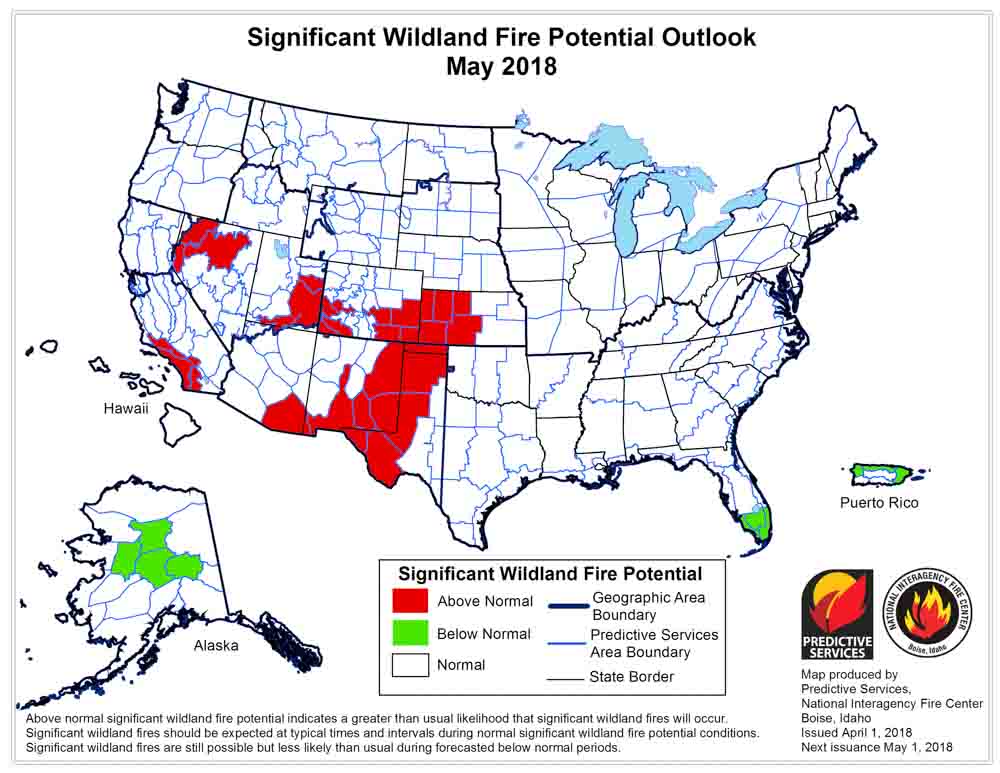
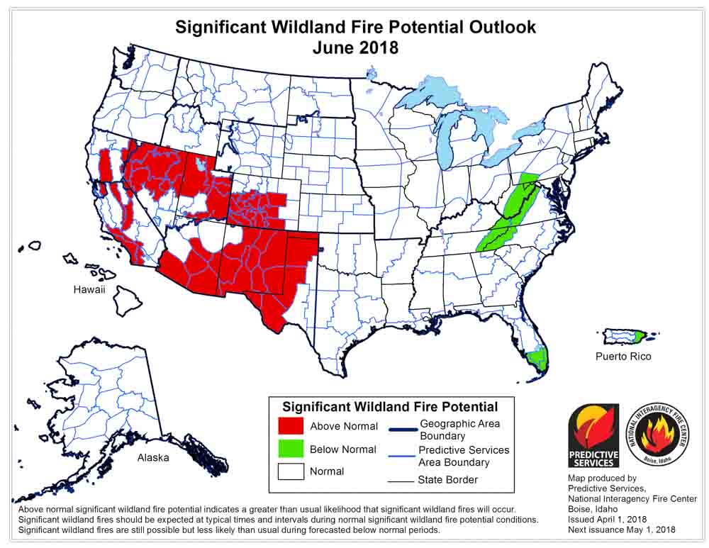
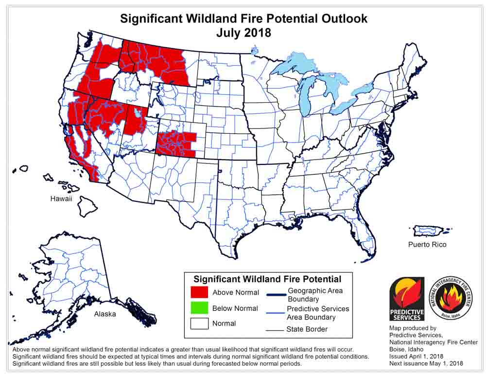
By July Montana, California, Colorado, and the states in the Northwest could see above normal wildfire activity

(Originally published at 8:55 p.m. MT April 1, 2018)

On April 1 the Predictive Services section at the National Interagency Fire Center issued their Wildland Fire Potential Outlook for April through July. The data represents the cumulative forecasts of the ten Geographic Area Predictive Services Units and the National Predictive Services Unit.

Below are:

  • The highlights of the NIFC narrative report for the next several months;
  • NIFC’s monthly graphical outlooks;
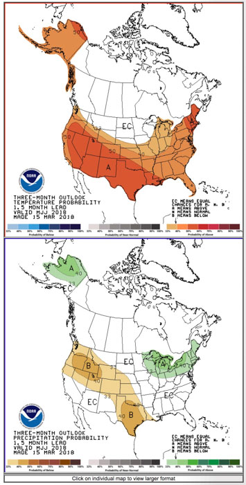
  • NOAA’s three-month temperature and precipitation forecasts; and
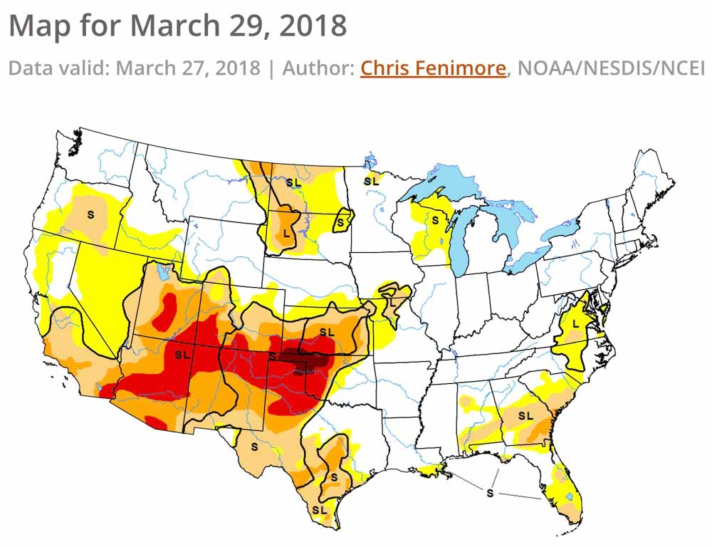
  • Drought Monitor.

“Wildfire activity will increase across portions of the nation in April. The central and southern Great Plains continue to experience significant wildland fire activity. While the activity observed is Above Normal, overall trends follow a traditional seasonal progression which keeps the fire potential elevated across these areas in early April but begins a westward shift further into the Southwest by month’s end. Periods of concern will be wind events coupled with low humidities that impact fire activity. Other areas of concern are the Florida Peninsula, eastern Georgia and South Carolina where drought conditions linger. Elevated potential exists across coastal portions of Southern California where drought continues and across portions of eastern Montana where very dry residual soil conditions exist. Pregreenup fire activity could elevate during westerly flow wind events.

“In May and June, the worsening drought conditions across the Southwest will lead to a continuance and expansion of the areas encompassed by an Above Normal potential for large fire activity. Fuels across the southern Great Basin and additional portions of California will become receptive as the vegetation dries and cures. Above Normal large fire potential across the Florida Peninsula in May will diminish by June as Sea/Land breeze convective activity begins to develop. Preexisting conditions across Alaska suggests a Normal potential for fire activity across the state’s interior.

“July marks the beginning of the core of the Western Fire Season. Concerns exist across the Interior West and California where a carryover of last year’s record grass crop coupled with the growth of an average grass crop this year will cure and become receptive. With a below average mountain snowpack observed from Oregon south to the border, an elevated potential may develop in the higher elevations by month’s end. Indicators suggest an early arrival of the Southwestern Monsoon. This should end the Southwestern season; however, the abundant convective activity will inevitably spread northward into the Great Basin and points north.”
wildfire potential May 2018 wildfire potential June 2018 wildfire potential July 2018

weather 90 day outlook

Drought Monitor
Drought Monitor

U.S. Supreme Court may hear case about 2007 Moonlight Fire

Moonlight Fire
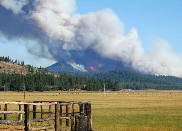
Moonlight Fire on first day, Monday, Sept. 3, 2007, as viewed from Highway 36.

The Moonlight Fire made plenty of news in 2007 as it burned 65,000 acres of U.S. Forest Service and state protected lands in Northern California (map).  But since then it has hit the headlines many times with various episodes of a series of scandals that have rocked the wildland fire and judicial systems. In the latest installment the U.S. Supreme court has been asked to hear a case related to the fire.

An investigation conducted by the USFS and the California Department of Forestry and Fire Protection (CAL FIRE) determined that sparks from a dozer working on land owned by Sierra Pacific Industries (SPI), a timber company in California, started the fire. There is a report that an employee in a lookout tower had left to make a one hour round trip to get a soda when the fire started. Upon his return the fire was well established. At another time, someone visiting that tower smelled marijuana and observed the employee peeing on his feet. The explanation for the latter was to treat athlete’s feet.

Based on the results of the investigation, the Department of Justice through the United States Attorney’s Office extracted a $55 million settlement from SPI and a requirement that the company hand over 22,500 acres of land. But SPI has always denied any responsibility for the fire.

As the case wound through the courts both sides (CAL FIRE/USFS/U.S. Attorney vs. SPI) accused the other of unethical conduct, including destroying or withholding evidence.

In 2009 a CAL FIRE investigator asked that a portion of the settlement, $7.7 million, be paid with a separate check  so that it could be deposited into an unusual off-the-regular-books non-government account. The WiFiter account used shortcut methods to procure items outside of the conventional appropriations and procurement system. Previously funds in the account had been used for off the books purchases of items such as 600 digital cameras and 26 evidence sheds.

Below are excerpts from a March 30 article in the Washington Post by Kathleen Parker:

…Next came the state case, where evidence of misconduct was so overwhelming that the judge threw out the case, calling the joint investigation and prosecution “corrupt and tainted” and saying that it “threatened the integrity of the judicial process.” He concluded that petitioners could not “ever have received . . . a fair trial,” and awarded SPI $32 million in compensatory sanctions — the largest sanction against a government body in U.S. history.

The Moonlight Fire case is sufficiently fascinating as a multifaceted drama, but it is certainly more than that. Ten state attorneys general have filed an amicus brief urging the Supreme Court to accept the case. Yet, even an outrageous case of prosecutorial misconduct isn’t enough to get the Supreme Court’s review.

This week a book was published about this bizarre saga, “Scorched Worth: A True Story of Destruction, Deceit, and Government Corruption”.

(To read all 10 of the articles we have written about the Moonlight Fire, click HERE.)

Thanks and a tip of the hat go out to Tim.
Typos or errors, report them HERE.

Wildfire burns about 250 acres on Santa Cruz Island

On Thursday 95 firefighters from California and Arizona were assigned to the fire.

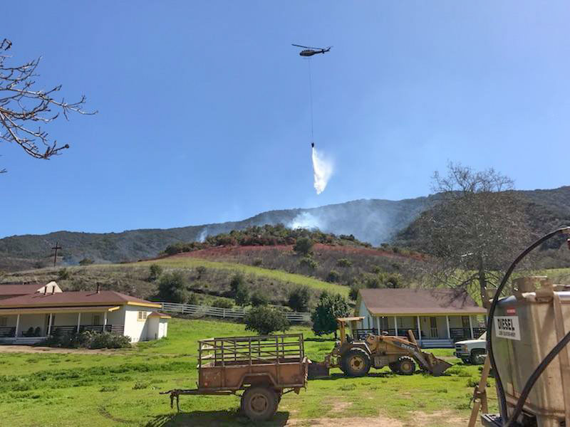
Above: Santa Cruz Fire, March 27, 2018. NPS photo.

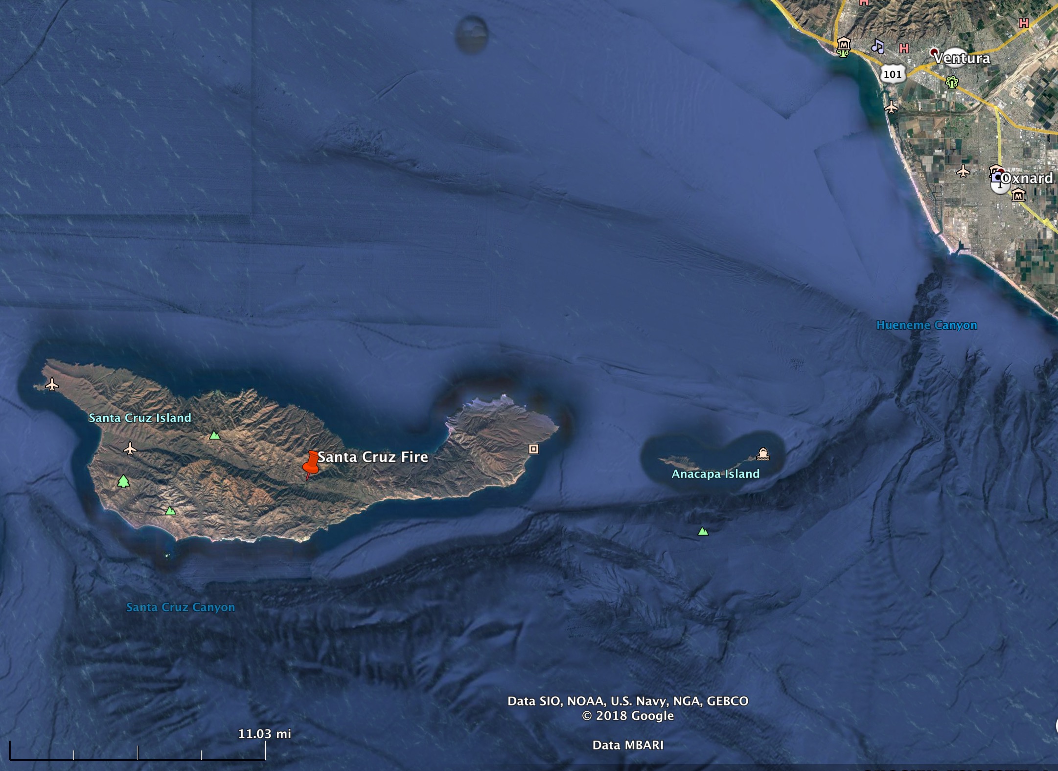
A wildfire that started Tuesday burned about 250 acres on Santa Cruz Island 20 miles off the coast southwest of Oxnard. The preliminary cause is a burn pile on Nature Conservancy land that escaped.

By Thursday firefighters slowed the spread assisted by lighter winds and a marine layer that brought higher humidities. Personnel, totaling 95, arrived from Santa Barbara County and the Los Padres, Sequoia, Sierra, and Tonto National Forests.

One small non-historic building burned in the fire.

Santa Cruz Island Fire
Santa Cruz Island Fire, March 28, 2018.

National Park Service spokesperson, Yvonne Menard, said air tankers, a mix of U.S. Forest Service contract aircraft and CAL FIRE S-2T’s, worked the fire — four on Tuesday and three on Wednesday along with at least one helicopter . The S-2T’s were dispatched from Paso Robles and the Forest Service aircraft came from Southern Arizona. They reloaded at Hemet Ryan, which is 155 miles southwest of the fire.

Santa Cruz Island, at 96 square miles, is the largest in the chain of eight California Channel Islands. The Nature Conservancy owns 76 percent of Santa Cruz Island and the National Park Service owns 24 percent. Together, they cooperatively manage the island as one ecological unit.

map Santa Cruz Island Fire
Map showing the location of the Santa Cruz Fire. Wildfire Today & Google Earth.
Santa Cruz Island Fire
Santa Cruz Island Fire, March 29, 2018. NPS Photo.
Santa Cruz Fire
Santa Cruz Island Fire, March 28, 2018. NPS photo.