More than a third of the large fires in the US on August 9 were not being fully suppressed

Above: Firefighters on the Liberty Fire in Montana, which is being managed using a less than full suppression strategy. Photo by Kari Greer.

(Originally published at 4:05 p.m. MDT August 10, 2017)

When we saw today that additional evacuations were required on the Sunrise Fire six miles south of Superior, Montana, a fire that is not being fully suppressed, we wondered how many fires are in that same less than full suppression category.

The table at the top of the national Incident Management Situation Report for August 10 (which uses data submitted the evening before) lists the number of uncontained large fires, but an asterisk leads to a note saying, “*Uncontained large fires include only fires being managed under a full suppression strategy.” The report today lists 24 large uncontained fires. After going through the 12-page document we found 13 other large fires that are not being fully suppressed, which is 35 percent of the 37 total large fires.

Unless you study the deciphering document about how to read the report, it is not obvious that any fires are not being fully suppressed. The column heading “Ctn/Comp” is the key. “Ctn” indicates the fire is being fully suppressed or contained, while “Comp” fires are not. Those codes are related to the column to the left which has a number referring to the percent contained (Ctn), or, the percent of the incident objectives that are complete (Comp) such as monitor, confine, or point zone protection on less than full suppression fires.
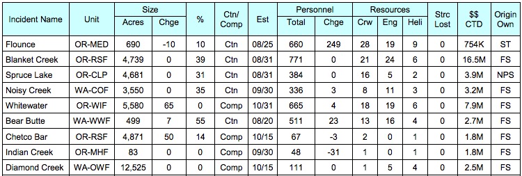
situation report
Example of the Situation Report from August 10, 2017. This is an excerpt showing some of the fires in the Northwest Area (Washington and Oregon). Click to enlarge.

Today’s report lists seven fires in the Northern Rockies Geographic area that are less than full suppression, the Northwest Area has five, and there is one in Northern California.

These 13 fires have burned approximately 99,000 acres, have 4,336 personnel assigned, and have cost about $79 million to date. The number of personnel is 28 percent of the total on all active uncontained fires, and the acres burned is 10 percent of the total.

The average “completion” for the 13 let burn less than full suppression fires is 19 percent. Most of them have estimated completion dates of late September to sometime in October.

Land managers who implement this strategy will tell you they want to restore fire to the landscape in an area where it has been unnaturally excluded, thereby enhancing the environment for plants and animals —  and people if it occurs near a wildland/urban interface. Reducing the vegetation, or fuels, can make it easier to suppress the next fire in the same area, perhaps resulting in fewer structures being destroyed. On fires like this they may completely stop the spread where it could damage private property, while only observing it or in some cases encouraging it to burn in more remote locations. The Incident Management Team on the Sunrise Fire included this in their status update on Thursday:

Over the next few days the team will work to slow the growth of the fire to allow for more effective and safe engagement by strategically introducing fire to unburned areas; lessening the likelihood for high-intensity and fast moving fire.

On the other hand, allowing a fire to spread over a period of months can have consequences, including producing smoke that contributes, along with full suppression fires, to an atmosphere that is unhealthy to breathe and puts more carbon into the air, millions of taxpayer dollars being spent, long-time exposure of firefighters to the hazards of firefighting, personnel being committed to long-term fires causing shortages on suppression fires, the inconvenience and expense of evacuated residents, and the possibility of fires uncontrollably burning private property and structures.

There is no easy answer. Scientists expect that the wildfire problem will get worse over our lifetimes and beyond. Continuing to do the same thing, that is, putting out most fires, is not going to produce different or better results. The population is growing and moving more into the wildland-urban interface while most local governments and insurance companies do little to regulate or mitigate this migration into the woods. Managers of parks and forests increasingly find themselves having to commit firefighters to protecting structures within or just outside their boundaries, while other sections of the fire spread with little resistance from depleted numbers of firefighters, equipment, and aircraft.

More evacuations ordered for the Sunrise Fire in western Montana

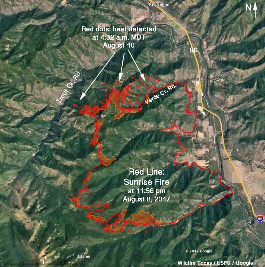
Above: 3-D map of the Sunrise Fire 6 miles south of Superior, Montana. The red line was the perimeter at 11:56 pm. MDT August 8. The red dots represent heat detected by a satellite at 4:32 a.m. MDT August 10.

(Originally published at 12:02 p.m. MDT August 10, 2017.)

Cougar Gulch has been added to the list of areas under evacuation orders on the Sunrise Fire which has been burning since July 16 six miles south of Superior Montana. Quartz Creek and Verde Creek were previously evacuated.

Tuesday night the fire was mapped at 15,203 acres, but has added approximately 1,000 acres since then primarily on the north and northwest sides, and a small amount on the south side. It has grown to within less than a mile of Trout Creek Road on the west side.

map sunrise fire montana
The red line on this map of the Sunrise Fire was the perimeter at 11:56 MDT August 8. The red dots represent heat detected by a satellite at 4:32 a.m. MDT August 10, 2017.

The Lolo National Forest is not completely suppressing the fire. Instead, they are stopping portions of it when they think it becomes necessary to protect private property. Thursday morning they released a statement that read in part:

Over the next few days the team will work to slow the growth of the fire to allow for more effective and safe engagement by strategically introducing fire to unburned areas; lessening the likelihood for high-intensity and fast moving fire.

On Wednesday burnout operations continued in the Quartz Creek and Verde Creek areas with hand and aerial ignition. The northern edge of the fire now extends into the head of Cougar Gulch.

Thursday’s plans are to continue burnout operations on the north side of Quartz Creek drainage to reduce fuel loading around structures. Firing will continue in Verde Creek.

Sunrise Fire
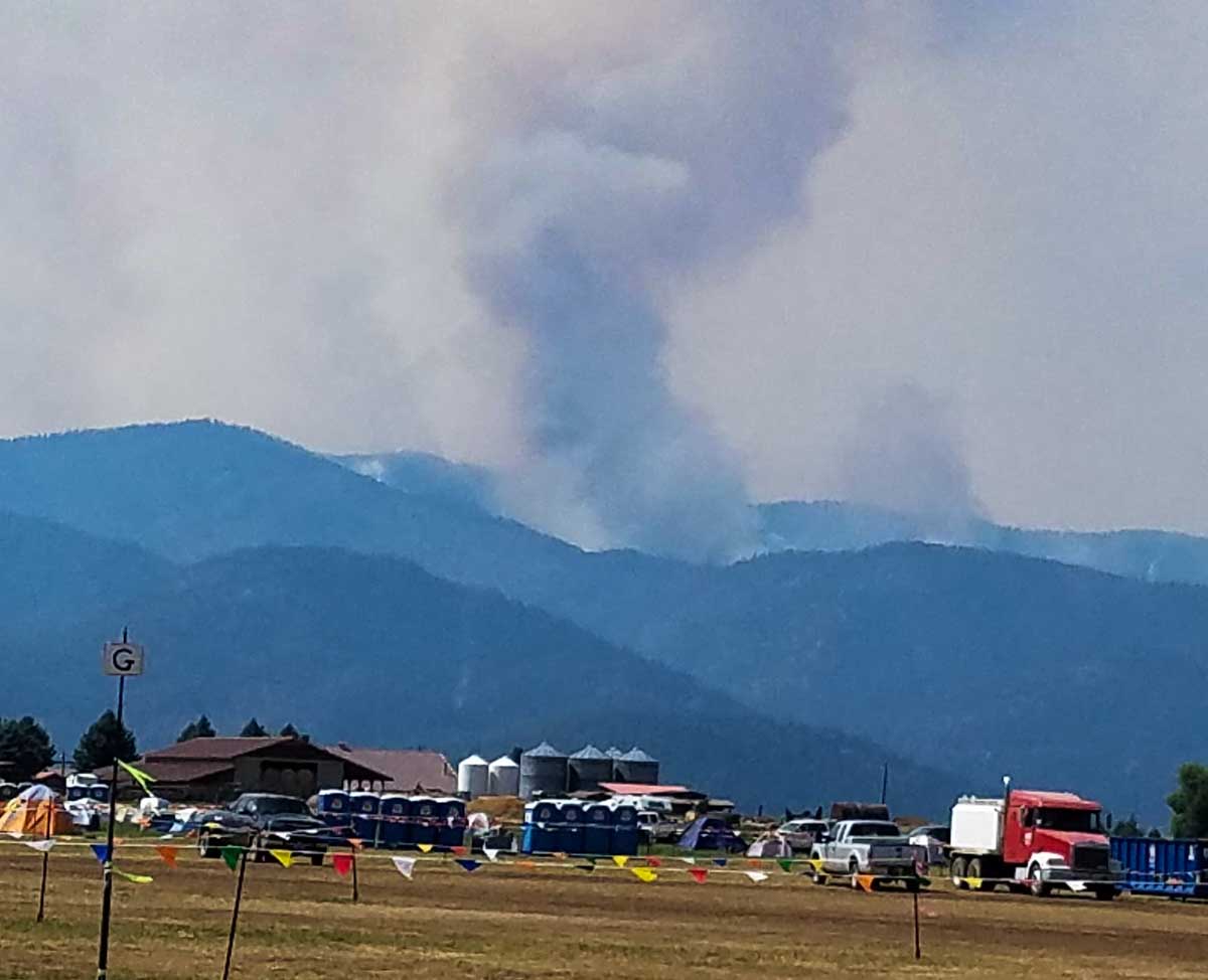
Smoke rising from the Verde Creek area on the Sunrise Fire. Inciweb. Undated and uncredited.

128 active wildfires in British Columbia as firefighters from North America and Australia arrive to help

Above: Map showing heat detected by a satellite in southern British Columbia at 2:51 a.m. MDT August 9, 2017.

(Updated at 5 p.m. MDT August 9, 2017)

The wildfire situation in British Columbia has not gotten any better in the last several days. Currently there are 128 active wildfires in the province, with four of them being larger than 50,000 hectares (123,000 acres). The largest, the Hanceville Riske Creek Fire, is getting closer to half a million acres each day.

Since April 1, approximately 591,280 hectares (1,461,082 acres) have burned in 900 fires in BC.

  • Hanceville Riske Creek, 172,000 hectares (425,000 acres) approximately 60 km southwest of Williams Lake.
  • Elephant Hill, 117,000 hectares (289,000 acres), near Ashcroft.
  • Tautri Lake, 76,000 hectares (188,000 acres), 80 km northwest of Williams Lake.
  • Baezaeko River-Quesnel West, 53,000 hectares (131,000 acres).

More than 400 additional firefighters from Australia, New Zealand, Mexico and the US are expected to arrive in BC this week. Other firefighters from Australia have been in the province for a couple of weeks. More than 100 firefighters arrived from Mexico since Saturday of last week. No resources have been ordered or dispatched to Canada through the United States National Interagency Coordination Center, but   the Great Lakes Interstate Forest Fire Compact mobilized a crew to Ontario that is now in British Columbia, and Massachusetts sent personnel across the border. Of course the northwestern one-quarter of the United States is pretty busy with their own fires.

Massachusetts firefighters British Columbia
Firefighters from Massachusetts board an aircraft on the way to the Elephant Hill Fire near Ashcroft, British Columbia. Photo by Mass. Department of Conservation and Recreation.
NSWRFS firefighters British Columbia
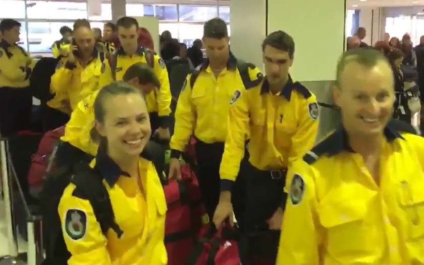
On Tuesday U.S. time 40 firefighters from Australia’s New South Wales Rural Fire Service joined 60 others from across the continent as they began their travel to British Columbia. Screenshot from NSWRFS video.

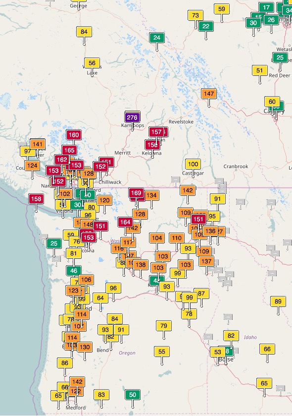
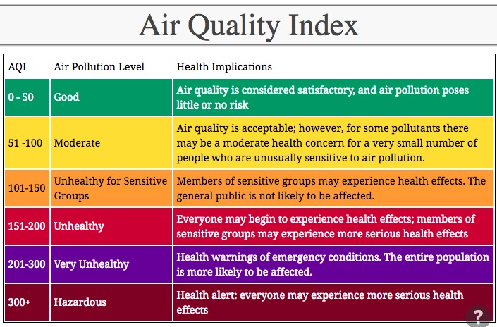
Smoke from wildfires in British Columbia, Washington, Oregon, Idaho, and Montana has created seriously degraded air quality off and on in those areas, at times reaching the “unhealthy” level according to air quality officials.

Air quality southern BC Washington Oregon
Air quality, southern BC, Washington, and Oregon.
Air Quality map
Legend for the above Air Quality map.

Red Flag Warnings, August 8, 2017

The National Weather Service has issued Red Flag Warnings or Fire Weather Watches for areas in California, Oregon and Idaho.

The map was current as of 10:35 a.m. MDT on Wednesday. Red Flag Warnings can change throughout the day as the National Weather Service offices around the country update and revise their forecasts.

Where are the unicorns?

It is great that the BLM is using social media for recruiting wildland firefighters Lead Range Techs. But this picture created a smile here.

What are your thoughts about this tweet?

Updated information about the wildfires in Greenland

The August 8, 2017 Deimos 2 image above shows one of the two wildfires currently burning in Greenland. When we wrote about the fires on August 7 it was the first time we had covered a fire on the island since we started Wildfire Today in 2008.

After our article was published other organizations also wrote about the fires. Online discussions developed over the last two days have included questions about the fire history of Greenland, and it turns out that no comprehensive reliable data has been unearthed. Researchers looking through satellite data have found historical heat detections by MODIS but many of the individual sensor trips are of low confidence, meaning they could be something other than a wildfire.

It appears that fires have occurred in Greenland, but at very low levels, and sporadically. We are not aware of the reliability of “wildfire CO2 emissions” to indicate the occurrence of wildfires, but the data presented by Mark Parrington (below) looks interesting.

Click once or twice on the images below to see larger versions.