Wildfire potential June through September

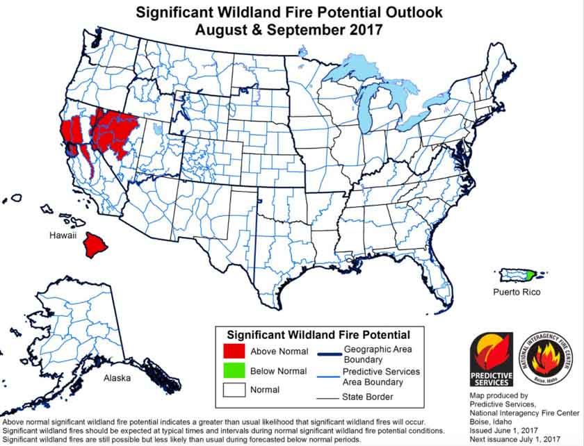
On June 1 the Predictive Services section at the National Interagency Fire Center issued their Wildland Fire Potential Outlook for June through September. The data represents the cumulative forecasts of the ten Geographic Area Predictive Services Units and the National Predictive Services Unit.

If it is accurate it looks like firefighters could be busy at times in Arizona, California, and Nevada, but not so much in the rest of the Western U.S.

Below are:

  • the highlights of their report;
  • NIFC’s graphical outlooks for June through September;
  • the Drought Monitor, and;
  • NOAA’s long range temperature and precipitation forecasts.

****

“Florida and Georgia experienced slight relief during the latter half of May as moderately wet systems produced widespread precipitation in both states. Activity across the southwest including Southern California began to increase toward month’s end as the region began to enter its core fire season. Nationally, the acres burned were above average at the end of May largely due to the fire activity that occurred in early March across the southern Great Plains where more than a million acres burned. The number of fires may be a more reflective number this year and remains below average for 2017.

Above normal precipitation and soil moisture is leading to a robust green-up across the West. Overall cooler than average temperatures and a heavy snowpack have led to slower than normal melting of the mountain snowpack in nearly all locations across the West. This should lead to a delayed start to the fire season in the higher elevations which may, in turn lead to a compressed season.

Above normal large fire potential will continue across southeastern Georgia and Florida into mid-June before the cumulative effects of precipitation events begin to take hold. Below Normal potential is expected across most of the remainder of the southeast through July before returning to Normal for August and September. Recent dry conditions across the southwest will lead to Above Normal potential across southeastern Arizona and Southern California. Below Normal to Normal large fire potential is also expected in the a majority of the higher elevations across the West in June and July.

July and August may be periods of concern. Above Normal potential is expected across the western portion of the Great Basin and across the middle elevations in California in July and August after the abundant grass crop cures. Fire activity will be mostly driven by short term weather events. Looking north, Alaska appears to be transitioning into a normal fire season for June and July with late summer rains ending the season across the interior in August. Extended dry conditions on the west side of the big island in Hawaii will lead to Above Normal potential that should last into September.”

wildfire potential July 2017

wildfire potential August September 2017

Continue reading “Wildfire potential June through September”

Static rocket test starts vegetation fire at Kennedy Space Center

Above: Static test firing of a SpaceX rocket, May 28, 2017 at the Kennedy Space Center. The smoke is from the rocket, not the vegetation fire. SpaceX photo.

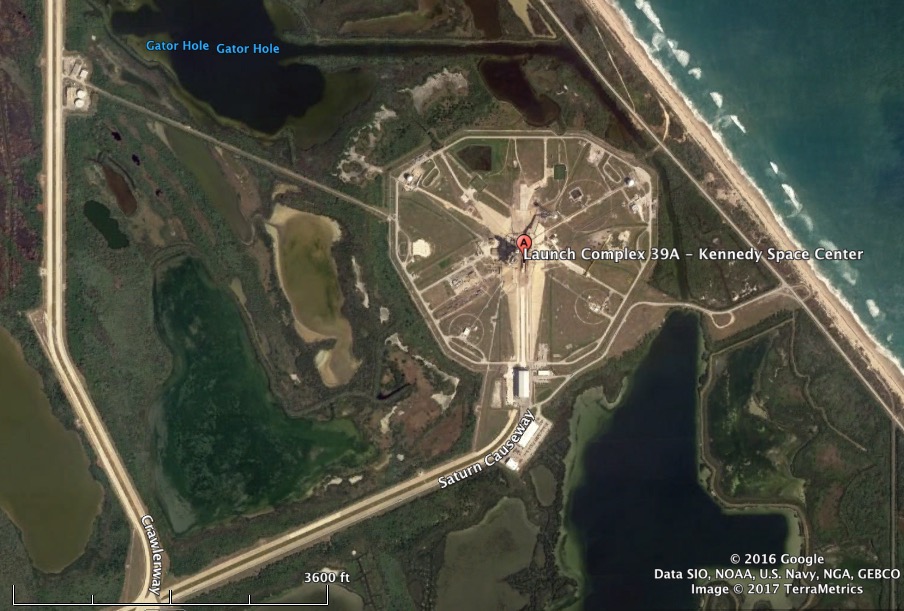
The static test firing of a rocket at the Kennedy Space Center in Florida started a vegetation fire in Merritt Island National Wildlife Refuge May 28. SpaceX was conducting a test of a Falcon 9 rocket at Launch Complex 39A when the fire accidentally started on what the U.S. Fish and Wildlife Service called a small island. With the aid of water drops from a helicopter the spread of the fire was stopped at four acres.

SpaceX plans to actually launch the rocket Thursday June 1 at 5:55 p.m. EDT to ferry a Dragon cargo ship to the International Space Station.

Merritt Island National Wildlife Refuge fire
The fire burned about four acres in Merritt Island National Wildlife Refuge. USFWS photo.
Launch Complex 39A photo
Launch Complex 39A at Kennedy Space Center.

First National Legacy Award presented to Forest Service retiree

Above: Dr. Jack Cohen makes a presentation at the 2011 Fire Litigation Conference in San Diego. Photo by Bill Gabbert.

Dr. Jack Cohen received the first National Legacy Award given by the U.S. Forest Service, National Association of State Foresters, National Fire Protection Association, and International Association of Fire Chiefs in recognition of outstanding career-long contributions to wildfire mitigation as an alternative to suppression. Dr. Cohen helped develop the U.S. National Fire Danger Rating System and developed calculations for wildland firefighters’ safe zones; created defensible space principles, which resulted in the Firewise program; the Home Ignition Zone; and conducted research on ember ignitions and structure ignitability.

His research laid the groundwork for nearly all of today’s work on wildland urban interface risk reduction. Until his 2016 retirement, he was a research scientist at Missoula Technology and Development Center. The award was presented at the IAFC WUI Conference in Reno, Nevada.

Thanks and a tip of the hat go out to Robert.
Typos or errors, report them HERE.

60 minutes: “Wildfires on the Rise”

Above: One of the homes that survived the Eiler Fire in northern California, August, 2014. Photo by Bill Gabbert.

The CBS TV show 60 Minutes recently aired a story titled, “Wildfires on the rise due to drought and climate change“, concentrating on how to deal with the increasing number of wildfires, and particularly what homeowners can do to protect their investments.

Below is an excerpt from the transcript:

Events like [the Yarnell Hill Fire that killed 19 member of the Granite Mountain Hotshots] add urgency to the work at a U.S. Forest Service lab. In this building in Missoula, Montana, scientists study how fires spread.

And one of them, Jack Cohen, made a specialty of how to better defend homes.

Jack Cohen: Clearly we’re not gonna solve the problem by telling people they’re gonna have to move their houses into a city from being out in the woods.

Steve Inskeep: Not gonna happen.

Jack Cohen: Right? It’s not gonna happen for a whole bunch of reasons, one of which is that the population who live there, including me– aren’t gonna do it.

Steve Inskeep: Is it reasonable for a homeowner in that situation, a fire bearing down on their neighborhood to just say, “Look, I pay my taxes. There are firefighters, there’s a fire department. The forest service, if it’s public land, has thousands of firefighters. It’s their job; put it out?”

Jack Cohen: So what if they can’t? Then the question becomes one of, “Well, if the extreme wildfires are inevitable does that mean that wildland-urban fire disasters are inevitable?” And my answer to that is no.

Growth of the Pinal Fire south of Globe, Arizona slows

Posted on Categories UncategorizedTags ,

Above:  Most of the activity on the Pinal Fire Saturday was a firing operation on Divisions A and D as the Payson and Prescott Hotshots were conducting burning operations along the ridge tops. The photo looks south from the western part of Globe, Arizona towards the Pinal Mountains.

The Pinal fire five miles south of south of Globe Arizona slowed on Saturday, adding about 200 acres to bring the total to 6,610 acres. On Sunday the fire was active on the north side six miles south of the community of Miami.

Firefighters have been conducting burning operations along Forest Road (FR) 651 to help keep the fire within the planned perimeter and lessen the impacts of post-fire effects. If conditions allow, the controlled burning will likely last about three to five more days.

All of the photos were taken by Tom Story during the afternoon of May 27, 2017.

Pinal Fire Arizona Globe
Members of the Escudilla Fire Crew hike along a ridge above homes in Kellner Canyon. The Type 2 crew was clearing brush around the residences as part of structure protection efforts on the Pinal Fire.
Pinal Fire Arizona Globe
Homeowner Jarom Lewis clears brush on his property adjacent to the Tonto National Forest on Kellner Canyon Road. The area south of the Globe City Limits along Kellner and Ice House Canyons was under a pre-evacuation order near the Pinal Fire south of town.
Pinal Fire Arizona Globe
The Escudilla Fire Crew clears brush along the Tonto National Forest boundary above homes in Kellner Canyon as part of structure protection efforts in an area under a pre-evacuation alert near the Pinal Fire in the mountains south of Globe, AZ.

LA County Fire Museum purchases Granite Mountain Hotshots’ crew buggies

Above: One of the Granite Mountain Hotshots’ crew buggies was near the front of the procession that brought the 19 fallen firefighters from Phoenix to Prescott, July 7, 2013. Photo by Bill Gabbert.

Tuesday night the Prescott, Arizona City Council voted unanimously to accept the bid of the Los Angeles County Fire Museum to purchase the two crew carriers (or crew buggies) that were used by the Granite Mountain Hotshots.

Nineteen of the 20 Granite Mountain Hot Shot crewmembers perished at the Yarnell Hill Fire on June 30, 2013.

The trucks, which carried the Granite Mountain Hotshots throughout the Southwestern U.S. during the 2013 wildfire season, were deemed “surplus properties” by the City of Prescott after it disbanded the crew. The museum’s bid of $25,000 for both vehicles was the only bid submitted, according to Prescott City Manager Michael Lamar. Under terms of the deal, both of the buggies will be owned by the County of Los Angeles Fire Museum.

One of the buggies will go to the County of Los Angeles Fire Museum in Bellflower, California and the other one is slated to be placed on loan to the Hall of Flame fire museum in Phoenix, Arizona. When a suitable facility is built in Prescott, the truck at the Hall of Flame will be moved to Prescott.