A couple of weeks ago the Coulson Group arranged to take some airborne photos of their three C-130 air tankers, including the one that just became operational at the end of April. Fire Aviation has more of the pictures.
Alternative map of wildland fire activity
Above: MODIS active fire data that shows fire activity from 2000-2015 for 1km pixels. Nicole M. Vaillant, Crystal A. Kolden, Alistair M. S. Smith.
On May 1 we published a map produced by FEMA with data about the number of wildfires by county in the United States that were larger than 300 acres between 1994 and 2013. As some of our readers pointed out the information apparently came from official fire reports filed by various jurisdictions, which does not guarantee that every wildfire is represented in the data.
After seeing the map, Krystal A. Kolden, a pyrogeographer and Associate Professor of Forest, Rangeland, and Fire Sciences at the University of Idaho sent us the above map. She said:
As an alternative, we created a map from MODIS [satellite] active fire data that shows fire activity from 2000-2015 for 1km pixels, so it’s normalized by area. This was published in the journal Current Forestry Reports last year.
The satellite data fills in some of the blank spots in the FEMA map, showing heat from all types of vegetation fires especially in the plains states where it’s not uncommon for a volunteer or rural fire department to suppress a 1,000-acre grass fire and then go on about their business — without completing a report. It also shows much more activity in the lower Mississippi River Valley and the Flint Hills of Oklahoma and Kansas where a great deal of prescribed fire and agricultural burning occurs.
But the MODIS satellite data is not perfect either. MODIS stands for MODerate Resolution Imaging Spectroradiometer on board NASA’s polar orbiting Earth Observing System Terra and Aqua satellites. The orbit of the Terra satellite goes from north to south across the equator in the morning and Aqua passes south to north over the equator in the afternoon resulting in global coverage every 1 to 2 days. Fires in light fuels, such as grass, can ignite, burn thousands of acres, and go out or be suppressed before the next overflight. Or, the fire might not be completely out but a large acreage of burned vegetation can cool and not be detected by the heat-detecting satellite flying hundreds of miles overhead.
This could change, however, when the new GOES-16 satellite becomes fully operational since it has much better resolution and is in geostationary orbit rescanning an area as often as every 30 seconds.
Dr. Kolden said, “The improved temporal resolution of GOES-16 may be a game changer for trying to quantify energy released from biomass burning, and to better understand how fire intensity is related to weather and climate.”
Sawyer mentorship
The Information officers on the Sawmill Fire in Arizona created this article and the photos. Not only does it give the outside world a peek into what wildland firefighters actually do (in this case while at the incident base) but it illustrates a great example of firefighters from the Globe Hotshots offering assistance or mentoring others when they have the time on a fire assignment. Firefighting of all types, structure and wildland, is a close-knit community and firefighters will help each other out even if they’re seeing each other for the first time, and knowing they may never meet again. Good job, Globe Hotshots and Wendy Koinva.
****
When Wendy Koinva started running a chainsaw, the guys on her crew told her it needed a name. “Give it a manly name,” they said. Wendy had another idea.
During the summer, a wildland firefighter spends thousands of hours carrying their pack, swinging their tool, and sleeping in their sleeping bag. Taking ownership of their things is important. If they take care of their gear, then their gear will take care of them. Sawyers have one of the most important and challenging jobs on the fireline. They are often in front, stomping through brush – clearing a safe way for their coworkers, their brothers and sisters, their buddies. If a sawyer is hungry and their saw needs gas, the saw gets fed first.
Wendy is a member of the Pima Type 2 Initial Attack Crew which is part of the Salt River Agency Tribal Nations Response Team. She’s been with the crew for two fire seasons. Her coworkers noticed her take an interest in running a saw. They suggested she take part in the tradition, among wildland sawyers, of naming her saw. It’s a way of taking ownership and pride in the job that they do. Wendy chose Pööts’tima, which is Hopi for “Stomping Bear,” because that’s how she sees herself and her saw. They are out in front, ahead of the crew, stomping through the brush and clearing the way.
While Wendy and Pööts’tima were “stomping” the Sawmill Fire, they came across the Globe Hotshots, led by Dean Whitney. Hotshot crews are elite. Hotshot sawyers are among the best at what they do. When Dean heard about Wendy and her saw, he recognized an opportunity for cross-agency mentorship. He invited her to come over to the crew’s buggies for a lesson, and worked with her on maximizing her and her saw’s potential.
Wildland firefighters value duty, respect, and integrity. We can all take a lesson from Globe, Wendy and her Stomping Bear.
Wildland fire activity by county
 FEMA produced this interesting map that plots the number of wildfires, by county, that were 300 acres or larger between 1994 and 2013.
What do you think? Any surprises?
(UPDATE, May 3, 2017: We have a different map of fire activity derived from satellite data, not reports submitted by fire departments.)
Wildfire potential, May through August, 2017
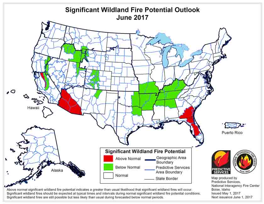
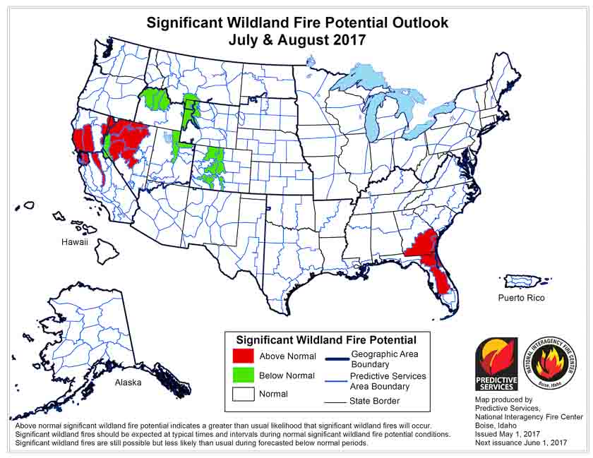
On May 1 the Predictive Services section at the National Interagency Fire Center issued their Wildland Fire Potential Outlook for May through August. The data represents the cumulative forecasts of the ten Geographic Area Predictive Services Units and the National Predictive Services Unit.
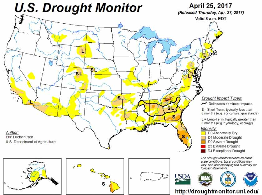
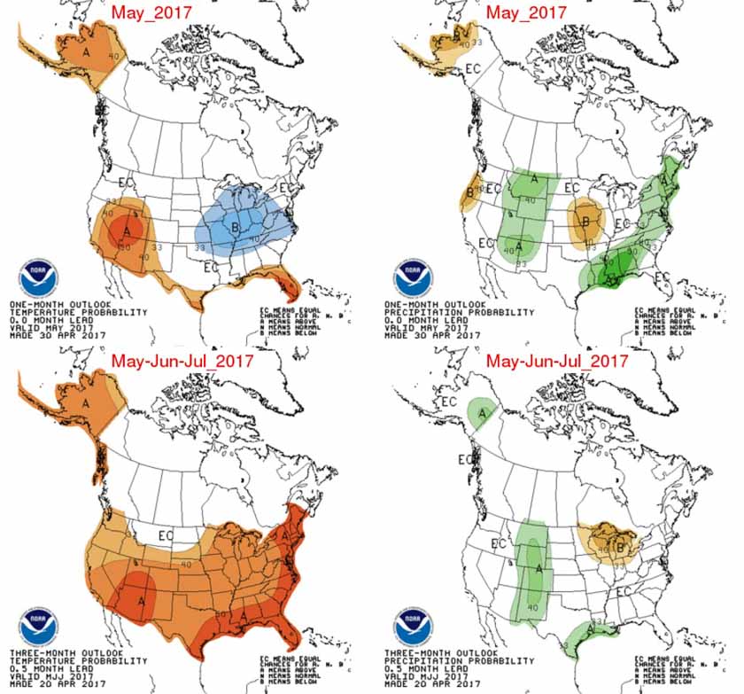
Below are the highlights of their report, NIFC’s graphical outlooks for May through August, the Drought Monitor, and NOAA’s temperature and precipitation forecasts.
Florida and southeastern Georgia continue to experience significant fire activity as warmer and drier than normal conditions persist. Worsening drought conditions in these areas continue to lead to increased fire activity and behavior. Recent precipitation events have not been significant or frequent enough to provide relief. The existing conditions and activity are expected to peak by early June before beginning to show improvement and subside as tropical patterns develop bringing beneficial precipitation.
Wildfire activity across the Southern Plains has begun to wane as the seasonal shift westward begins. Greenup has begun to take hold and precipitation events have become more common across the Central and Northern Plains.
Arizona and western New Mexico will see an increase in fire activity in May and June as the region enters the heart of its fire season. Heavy growth of fine fuels across southern Arizona and southwestern New Mexico have led to above normal fire potential along the Mexican border that should persist through June before the monsoonal rains arrive in early July and decrease activity.
As the fire season progresses into July, there are concerns with the seasonal shift west and north into California, and Great Basin. Exceptional winter and early spring precipitation is leading to the development of a substantial crop of fine fuels in the lower and middle elevations. The heavy loading of fine fuels could become problematic when they cure out in July. In the higher elevations, the mountain snowpack continues to melt at a normal to slower than normal rate. This should produce a delay in the onset of significant fire activity in the high elevations.
In Alaska, the south central portion of the state continues to be abnormally dry. While overall normal fire potential is forecast, bursts of more significant fire activity are possible across the interior portion of the state.
By mid-late July, the western fire season will begin to progress north into the Pacific Northwest and Northern Rockies. While a normal transition into fire season is expected in the lower elevations, a delayed entrance is possible in the higher elevations as both regions enter their fire seasons having seen abundant winter and spring precipitation and snowpack accumulation.
What does Logistics do on a wildfire in Florida?
Above: Logistics Section Chief Cindy Schiffer with the Southern Area Blue Team. From the video.
We appreciate it when local units put together short videos, especially at a fire, showing the public what they are doing. This particular one, filmed at the 21,000-acre Cowbell Fire at Big Cypress National Preserve in south Florida, features Logistics Section Chief Cindy Schiffer explaining how her section provides the support firefighters need to continue battling the fire. It’s very well done.


