Cedar Fire near Show Low, Arizona

(UPDATED at 10 a.m. MDT June 24, 2016)

cedar fire helicopter
Helicopter refilling water bucket on Cedar Fire. Undated & uncredited photo from InciWeb.

The Cedar Fire south of Show Low, Arizona continues to spread across the Arizona landscape. The Incident Management Team reports that it has burned 45,918 acres, an increase of about 5,000 acres over the last two days. Firefighters still have miles of open fire perimeter and have been working on constructing firelines and conducting burnouts on the east and west flanks.

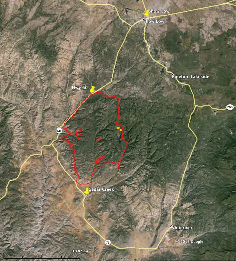
Map Cedar Fire
Map of the Cedar Fire perimeter at 9 p.m. MDT June 23, 2016.

SR-60 between Carrizo and Show Low remains closed due to smoke conditions as firefighters actively work near the highway. SR-73 through Whiteriver remains open from Carrizo to Hon-Dah.

****

(UPDATED at 9:42 a.m. MDT June 22, 2016)

3-D Map Cedar Fire
3-D Map of the Cedar Fire at 10 p.m. MDT June 21, 2016. Looking north.Click to enlarge.

The Cedar Fire south of Show Low Arizona added another 5,000 acres on Tuesday to bring the number acres burned up to 40,340, according to the Southwest Geographic Area Coordination Center. Most of the growth was on the east side, and on the west side near Highway 60.

The southern perimeter is still approximately 1 1⁄2 miles north of Highway 73, and approximately 2 miles north of the Cedar Creek community. The north side of the fire remains fairly quiet.

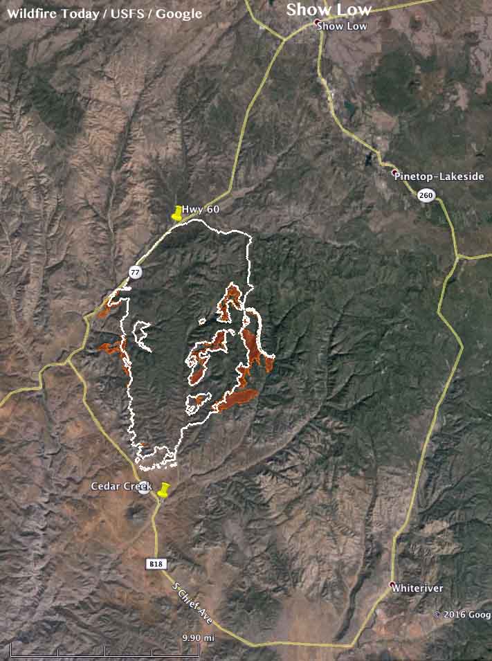
Map Cedar Fire
The brown shaded areas show the additional growth of the Cedar Fire as of 10 p.m. MDT June 21, 2016. The white line is the perimeter from 24 hours before. Click to enlarge.
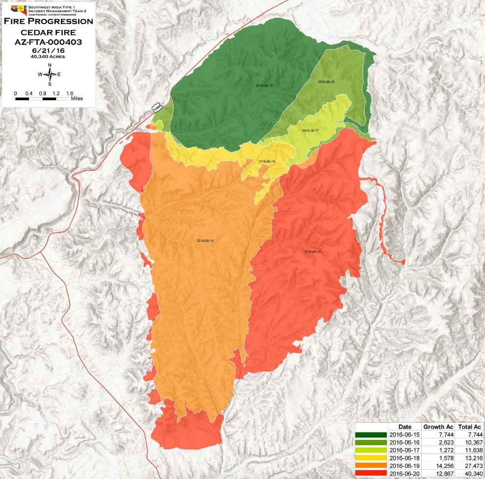
Progression map Cedar Fire
Progression map of the Cedar Fire, June 21, 2016. Click to enlarge.

****

(UPDATED at 8:20 a.m. MDT, June 21, 2016)

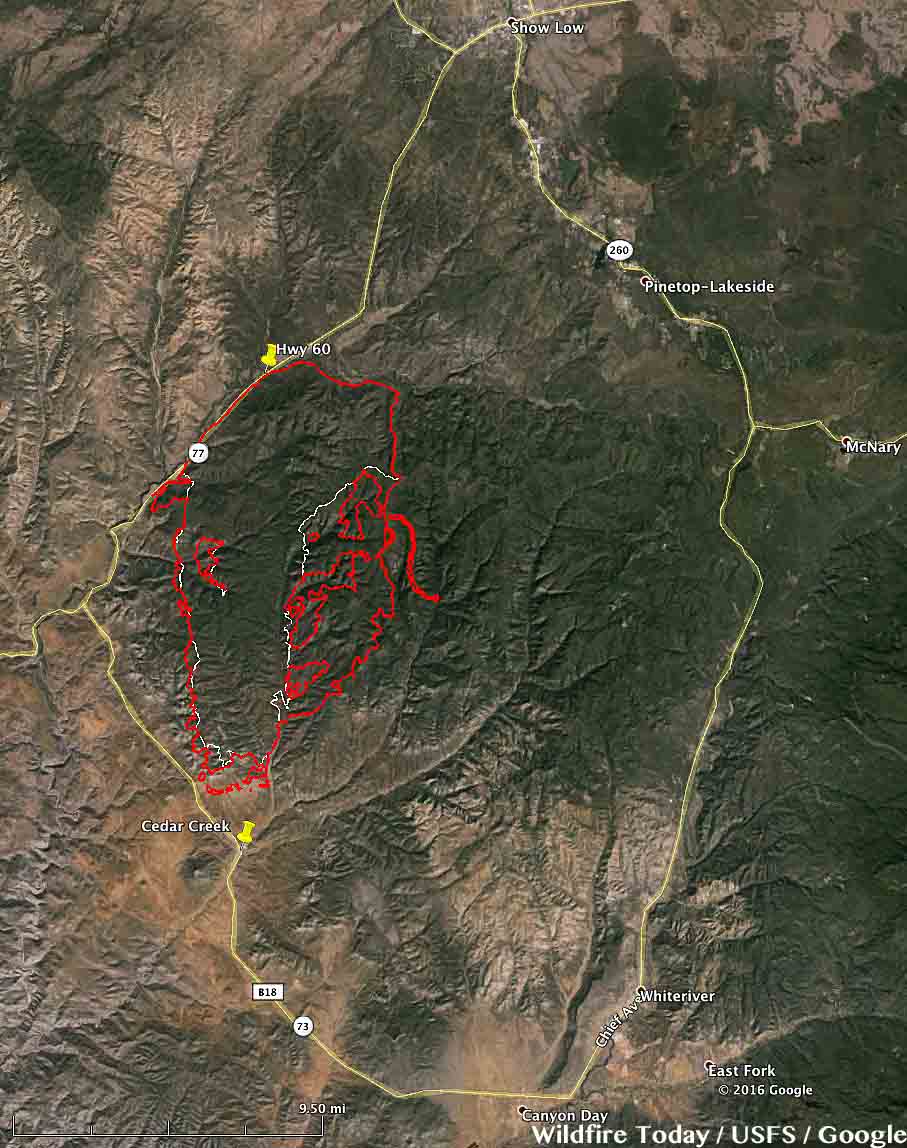
map Cedar Fire
The red line was the perimeter of the Cedar Fire at 4:13 a.m. MDT June 21, 2016. The white line was the perimeter from about 24 hours before. Click to enlarge.

The Cedar Fire south of Show Low, Arizona continued to grow substantially on Monday adding another 9,000 acres to bring the total burned area up to about 35,000 acres. The fire was active on the southwest and south sides, but was extremely active on the east side where it spread over two miles further east.

The Incident Management Team (IMT) has posted a video briefing on the fire that was recorded on Monday.

Continue reading “Cedar Fire near Show Low, Arizona”

Satellite photo shows three large columns of smoke in Arizona & New Mexico

Above: map showing three large columns of smoke in Arizona and New Mexico, at 5:15 p.m. MDT, June 15, 2016.

The satellite photo above shows three large columns of smoke in Arizona and New Mexico. We have tentatively identified them, but this is not yet confirmed, as the North Fire (25 miles southwest of Magdalena, NM), the Dog Head Fire (about 25 miles southeast of Albuquerque, NM), and the Cedar Creek Fire, a new fire 12 to 16 miles southwest of Show Low, Arizona.

The North Fire is a limited suppression fire, while the other two are being fully suppressed.

The Cedar Creek Fire started around noon on Wednesday and by 3 p.m. had burned about 1,000 acres. Strong winds were pushing it toward Show Low. Fire officials have identified a trigger point. If the fire reaches the B65 Road they will order evacuations of Show Low and Forestdale.

Earlier today we posted information about six fires in these two states, including the North and Dog Head fires.

Strong winds were predicted for parts of Arizona and New Mexico today, along with a Red Flag Warning for the area southeast of Albuquerque, NM.

wind forecast arizona
The wind gust forecast for 3 p.m. MDT June 16, 2016.

Thanks and a tip of the hat go out to Tom.

Wildfire activity in Arizona and New Mexico

Above: Dog Fire, June 14, 2016. Photo by Incident Management Team.

Cool, wet weather has slowed wildfire activity in Northern California, Washington, and Oregon. The 2,396-acre Pony fire on the Klamath National Forest, about 15 miles southwest of Happy Camp, received rain on Tuesday.

It is a different story in Arizona and New Mexico where more than half a dozen fires have burned significant acreage. All of them are limited suppression fires except for the Dog Head Fire that started Tuesday morning.

Jack Fire

This limited suppression fire has burned 36,408 acres in central Arizona 24 miles southeast of Sedona. This is an increase of about 11,000 acres over the last three days. There is a red flag warning in effect from 11 a.m. Wednesday morning to 7 p.m. in th evening due to strong winds and low relative humidity for the area. Higher temperatures and low relative humidity are expected over the next couple days.

Dog Head Fire

Rich Nieto’s Type 2 Incident Management Team will assume command of this 682-acre fire Wednesday evening. It started at 11 a.m. on Tuesday and as of Wednesday morning voluntary evacuations are occurring for Monzano Morning, Aceves Road, and La Parra Road.

Today they expect temperatures in the 80s and low 90s, southwest wind of 10 to 25 with gust to 35, and relative humidity around 10 percent.

It is about 25 miles southeast of Albuquerque, New Mexico on the Cibola National Forest and National Grassland. This is the only one of these six fires that is not a limited suppression fire.

McKenna Fire

This limited suppression fire northwest of Silver City, New Mexico has burned 10,210 acres since it was reported on May 6.

North Fire

This limited suppression fire has burned about 22,000 acres 25 miles southwest of Magdalena, New Mexico since it was reported on May 21.

North Fire
North Fire. Undated photo by Ken Watkins.

Spur and Turkey Fires

The Gila National Forest in southwest New Mexico is releasing very little information about these two limited suppression fires that at last report had each burned between 2,000 and 3,000 acres.

Arizona: Tenderfoot Fire causes evacuations in Yarnell

(UPDATED at 7:34 p.m. MDT June 11, 2016)

The Tenderfoot Fire at Yarnell, Arizona grew slowly on Saturday and is now at 4,040 acres, according to the incident management team. Fire activity was moderated by moisture received on the fire Friday night, along with cooler daytime temperatures and higher relative humidity.

Incident Commander Sinclair stated that “work of the heavy air tankers made a significant contribution towards reducing the spread of fire on the north side of the incident yesterday”.

Highway 89 is now open and the mandatory evacuation on the east side of Yarnell was lifted at 6 p.m. on Saturday. There are no other evacuation orders in effect.

Resources assigned include 8 hand crews, 22 engines, 5 helicopters, 3 dozers, and 353 personnel.

****

(UPDATED at 9:18 p.m. MDT June 10, 2016)

The Incident Management Team provided some updated information Friday afternoon about the Tenderfoot Fire at Yarnell, Arizona:

The fire is currently moving away from the Community of Yarnell in a northeasterly direction, an area where very few structures are present. This area is very rugged in character with very little access. Fire managers will be looking for opportunities to the northeast of the current fire area where firefighters can safely engage and suppress the fire south of Wagoner Road.

There are currently no immediate threats to structures. Over the last few years fuel reduction projects were completed on the east and north sides of the Community of Yarnell. Fire Chief Ben Palm stated that these fuel breaks significantly reduced the fire intensity of the Tenderfoot Fire as it approached the community, allowing firefighters to attack the fire and greatly reduce property loss. The fuel breaks were the result of a partnership between the Community and Arizona State Forestry and the Bureau of Land Management.

This afternoon the Yavapai Sheriff’s Office announced the opening of State Highway 89 at 4:00 p.m.

****

(UPDATED at 8:45 a.m. MDT, June 10, 2016)

Tenderfoot Fire
Tenderfoot Fire, June 9, 2016. InciWeb photo.

The Tenderfoot Fire at Yarnell, Arizona was very active Thursday afternoon and Thursday night, more than doubling in size to approximately 3,300 acres according to information released by the incident management team. That acreage may change after personnel map the fire via helicopter later today.

map Tenderfoot Fire
Map showing the perimeter of the Tenderfoot Fire. The red line was mapped using a fixed wing aircraft at about 11 p.m. MDT, June 9. The red dots represent heat detected by a satellite at 4:29 a.m. MDT June 10, 2016.

The Southwest Area Type 2 Incident Management Team #3, with Incident Commander Alan Sinclair, assumed command of the fire at 6 a.m. on Friday.

****

(UPDATED at 10:40 p.m. MDT, June 9, 2016)

The Tenderfoot Fire at Yarnell, Arizona south of Prescott became more active in the late afternoon on Thursday and has now burned over 1,300 acres. The heat data in the map below acquired at 2:27 p.m. MDT on Thursday showed additional fire spread on the east and the northeast sides.

At about 3 p.m. a mandatory evacuation notice for Peeples Valley on the east side of Highway 89 was issued. It was a precautionary evacuation and with no imminent threat at that time.

Tenderfoot Fire 227 pm
Map showing heat detected by a satellite on the Tenderfoot Fire at 2:27 p.m. MDT June 9. It is possible that some light vegetation burned and cooled before the heat data was captured — the fire could be larger than indicated here.

The increase in fire behavior was a result of the wind increasing to 13 mph after noon, while the relative humidity dropped to 18 percent.

weather yarnell AZ
Weather observations at ASTA3 just southeast of Yarnell, AZ.

Continue reading “Arizona: Tenderfoot Fire causes evacuations in Yarnell”

Six students receive scholarships honoring victims of Yarnell Hill Fire

Intended for one recipient, unexpected donated funds allowed six students to receive scholarships.

Photo above: left to right starting at the top: Tri-City College Prep Winners: Hannah Leber, MaKaylee Call and Shelbyrae Myers. Bagdad High School Winners: Alexandra Provencio and Marissa Rottnek. Prescott High School winner: Morgan Feingold.

(Guest post written by Katie Knoll)

PRESCOTT, ARIZ. (May 24, 2016) – Six Yavapai-area high school students each received $2,000 Grant McKee Service and Leadership Scholarships during May’s North Star Youth Partnership’s Celebration of Community breakfast.  The annual breakfast recognizes North Star’s teen leaders, programs, community partners, and volunteers. Originally intended as a single $2,000 scholarship, additional unexpected funds from the Taylor Family Foundation and the American Legion in Prescott allowed for each of the six finalists to win a scholarship.

“Seeing the shock and joy on the girls’ faces was priceless, and it was so much fun to have an ‘Oprah moment’ as everyone got a scholarship!” says Diane DeLong, North Star’s Senior Program Manager.

Grant Quinn McKee was one of the 19 firefighters who perished in the Yarnell fire in 2013, and he will forever be remembered for his service to the community, his leadership skills, and his desire to make the world a better place.  At Prescott High School, McKee was a member of North Star Youth Partnership’s Peer Assistance and Leadership (PAL) Program.  This scholarship, in its third year, honors McKee’s memory along with his cousin Robert Caldwell, a fellow Hot Shot and leader who also perished in the fire.

To qualify for the scholarship, students were required to be members of a PAL school program, which help teens learn skills to make a positive difference in their schools, community, and their own life.  PAL trains teens in communication and facilitation skills, active listening, decision-making, and problem solving, and PAL also exposes youth to service projects that impact their schools and communities.

The scholarship winners are Shelbyrae Myers, MaKaylee Call, and Hannah Leber, each of Tri-City College Prep; Morgan Feingold of Prescott High School; and Alexandra Provencio and Marissa Rottnek of Bagdad High School.  Each young woman wowed the scholarship review panel with her scholastic achievements, extracurricular activities, and community service.

Applications for the 2017 Grant McKee and Robert Caldwell Service and Leadership Scholarship will be accepted through North Star beginning January 2017.

For more information about North Star Youth Partnership and the Peer Assistance and Leadership (PAL) program or the Grant McKee/Robert Caldwell Service and Leadership Scholarship, please contact Diane DeLong, Senior Program Manager, at ddelong@cc-az.org.

Founded in 1933, Catholic Charities provides care for the vulnerable of all faiths in Phoenix and northern Arizona through programs in foster care, early start education, housing, veteran services, refugee relocation and poverty reduction. Learn more by visiting www.catholiccharitiesaz.org. Social connections include www.facebook.com/CatholicCharitiesAZ and twitter.com/CCArizona.

Arizona: Coconino National Forest managing two less than full suppression fires

(Originally published at 9:48 a.m. MDT May 24, 2016)

Map Cowboy Mormon Fires
Map showing heat detected by a satellite on the Cowboy and Mormon Fires south of Flagstaff, Arizona. The brown and red dots represent heat during the 24 hours ending at 3:07 a.m. MDT May 24, 2016.

The Coconino National Forest is managing two lightning-caused fires south of Flagstaff, Arizona. Named the Cowboy and Mormon Fires, they were reported on May 17 and 15, respectively. The Forest management staff has decided that they will use a less than full suppression strategy for both.

The maximum management area (MMA) for the Cowboy Fire, 8 miles south of Flagstaff, is 3,425 acres, with about four miles of the possible perimeter being very close to Interstate 17. The fire has been very active over the last 24 hours. The U.S. Forest Service reported on Monday that the fire had burned 5 acres, but using recent satellite data our very unofficial calculations show that it has burned approximately 400 acres.

Maximum Management Area Cowboy Fire
Maximum Management Area for the Cowboy Fire. The USFS expects the fire will not exceed this area. USFS.

Forest Service officials intend to limit the Mormon Fire, 16 miles southeast of Flagstaff, to 11,664 acres. It has also been active in the last 24 hours but not as much as the Cowboy Fire. The agency reports that as of Monday the fire had burned 350 acres.

Maximum Management Area Mormon Fire
Maximum Management Area for the Mormon Fire. The USFS expects the fire will not exceed this area. USFS.

It will be interesting to see how the partially greened-up vegetation on these fires at 7,000 feet elevation will be affected by the strong southwest winds that are predicted for the rest of this week. On Tuesday the wind forecast is 24 mph gusting to 39, along with a relative humidity of 24 percent and a temperature of 61 degrees. Wednesday through Sunday the forecast calls for winds of 12 to 18 mph gusting at 20 to 30 mph. There is very little chance of rain this week.

Cowboy Fire
Cowboy Fire as seen from Lake Mary, May 23, 2016. USFS photo by Brady Smith

Cowboy fire