Two large fires threaten communities near Globe, Arizona

Telegraph and Mescal Fires

10:53 a.m. MDT June 6, 2021

Map of the Telegraph & Mescal Fires
Map of the Telegraph & Mescal Fires at approximately 12:45 a.m. MDT June 6, 2021.

Two large wildfires east of Phoenix, Arizona are threatening communities near the city of Globe. They are both being driven by strong winds out of the southwest as they burn vegetation desiccated by drought. The hot, dry, and windy conditions that are expected to continue through Friday with 10 to 15 mph winds gusting at 20 to 25 or higher with humidity in the teens will make it a challenge for firefighters to stop the spread of these two fires.

To see all articles on Wildfire Today about the Telegraph and Mescal Fire, including the most recent, click HERE.

air tanker drop Telegraph Fire
Tanker 914, a Douglas DC-10, makes a retardant drop on the western end of the Telegraph Fire late on the afternoon of June 5, 2021 outside of Superior, Arizona. Photo by Tom Story.

Telegraph Fire
The Telegraph Fire south of Highway 60 is 12 miles southwest of Globe, 1.5 miles south of Superior, and about 1 mile from Top of the World. Most of the spread over the last 24 hours has been to the northeast but it has backed into the wind on the west side. Highway 60 is closed.

There is extensive copper mine infrastructure on the northeast and southeast sides of the fire and is moving toward the community of Top of the World. At about 10 a.m. Sunday the sheriff’s office ordered a “GO! Evacuate!” order for the town.

The photo below was taken Saturday night.

Saturday evening the size of the Telegraph Fire was estimated at 25,000 acres. Sunday morning the incident management team announced it had burned 34,363 acres.

Telegraph Fire Arizona helicopters
Helicopter 406AS, the Payson Helitack Exclusive Use ship departs the Superior Helibase for a recon mission on the Telegraph Fire on the Tonto National Forest June 5, 2021. Helicopter 23HX, the Siskyou Rappel ship waits for it’s call to continue bucket work. Photo by Tom Story.

Mescal Fire
During the overnight mapping flight the Mescal Fire was north of San Carlos Reservoir, 2 miles south of Highway 70, and 12 miles southeast of Globe. It was spreading toward the communities of Peridot and San Carlos which Saturday night were 4 and 6 miles away, respectively. On Saturday firefighters conducted a strategic firing operation ahead of the fire along Coolidge Dam Road.

Saturday evening the size of the Mescal Fire was estimated at 25,600 acres. The overnight mapping flight will likely show that it has grown to more than 38,000 acres. (Update: at about 11:15 a.m. on Sunday the incident management team announced that the fire had burned 38,702 acres.)

Telegraph Fire Superior AZ
At sunset on June 5, 2021, the western edge of the Telegraph Fire had crested the ridge to the east of Superior, Arizona and began backing down the hill towards Highway 77. Photo by Tom Story.

Two wildfires east of Phoenix grew rapidly on Friday

South of Globe, Arizona

5:31 p.m. MDT June 5, 2021

Mescal Fire
According to the San Carlos Apache Tribe Emergency Response Commission, evacuations have been ordered for Coyote Flats Peridot Heights, the San Carlos High School Area, and all residents along Route 3.

The fire has burned more than 25,600 acres and has 400 personnel assigned, led by Southwest Area Incident Management Team 5.

(To see all articles on Wildfire Today about these fires, including the most current, click here.)

Telegraph Fire
The incident management team (IMT) announced the estimated size has been updated to 25,000 acres. A Type 1 IMT has been ordered. The Sheriff’s Office has placed the towns of Superior and Top-of-the-World in “SET- Be Alert” status due. This means there is significant danger in the area, threatening approximately 150 residents — be ready to evacuate if notified from public safety officials. This is NOT an evacuation notification.

An estimated 150 personnel are managing the fire including 3 hand crews and 5 engines, with additional support from the State of Arizona, Gila District Bureau of Land Management, and Pinal County. A Type 1 Incident Management Team has been ordered.

Smoke
Below is the smoke forecast for Saturday evening at 8 MDT. Heavy smoke from the Mescal and Telegraph Fires is projected to move east into Southern New Mexico and Texas toward El Paso and Juárez.

Smoke Forecast Mescal and Telegraph Fires
Smoke Forecast for 8 p.m. MDT June 5, 2021. Heavy smoke from the Mescal and Telegraph Fires is projected to move east into Southern New Mexico.

12:19 p.m. MDT June 5, 2021

map Telegraph & Mescal Fires Arizona
Map, showing the locations of the Telegraph & Mescal Fires in Arizona.

Two wildfires east of Phoenix, Arizona were very active Friday, exhibiting extreme fire behavior while pushed by strong winds.

Mescal Fire

The Mescal Fire 60 miles east-southeast of Phoenix and 12 miles southeast of Globe spread several miles to the east and northeast Friday, pushed by strong winds gusting to 34 mph, coming to within less than two miles of the north shore of San Carlos Reservoir. The west side of the fire continued to move to the west. (see map above)

The incident management team reported Friday that it had grown to 7,900 acres since it started June 1. Heat detected by satellites indicates that with the growth late Friday and into the night it could be two to three times that size, but mapping aircraft were not available Friday night to update the mapped perimeter.

Telegraph Fire

The Telegraph Fire is 35 miles east-southeast of Phoenix and 18 miles southwest of Globe. As this was written before noon on Saturday it had been burning approximately 24 hours. Officially it is 3,500 acres but with recent growth could be more than 5,500 acres. The Pinal County Sheriff’s Office placed the town of Superior in “SET-Be Alert” status at about 11 a.m. Saturday, meaning there was significant danger from the fire, but evacuations had not been ordered at that time. (Sign up for alerts.)

Fire officials said they expect it to move to the north and east Saturday with extreme fire behavior.

Telegraph Fire Arizona
Telegraph Fire, June 4, 2021. InciWeb photo.

Weather

The weather forecast for the area is for hot, dry, and breezy conditions to persist through the weekend, with wind gusts up to 30 mph, daytime humidities in the single digits, and high temperatures near 100. These conditions will make it a challenge for firefighters to make a lot of progress toward containing the fires. A Red Flag Warning is expected to be in effect Saturday afternoon.

Telegraph Fire Arizona
Telegraph Fire, June 4, 2021. InciWeb photo.

Forecast for smoke from Arizona’s Tussock Fire

Tussock Fire smoke plume May 10
Tussock Fire predicted smoke plume. May 10. Arizona Department of Environmental Quality.

The Arizona Department of Environmental Quality expects that smoke from the Tussock Fire will generally disperse to the east Monday and Tuesday. The fire is 27 air miles northwest of the northern Phoenix suburbs.

Below is their prediction issued at 9:47 a.m. on Monday May 10, 2021:

“[Monday] is expected to be another windy day, with south-southwest winds in the 10-20 mph range. Smoke is forecast to rise and disperse toward the east-northeast. Smoke may move over Camp Verde, Payson, and Winslow; however, smoke is expected to be elevated off the ground. Some smoke may drop down the backside of the Bradshaws Mountains this afternoon and into Bumble Bee, Cordes Lakes, Cleator, and Mayer, but impacts are expected to be short-lived.

“[Tuesday], as high pressure builds into the region, smoke is forecast to rise and disperse toward the east-southeast, with some smoke moving over the far north portion of the Phoenix Valley. This smoke is expected to be elevated well off the ground, so not forecasting any smoke impacts to the Valley. With that said, Anthem, New River, and Cave Creek may briefly smell smoke, especially in the late evening on Tuesday.”

The forecast below for Arizona is for 6 p.m. MDT May 10, 2021, produced by NOAA.

Smoke Forecast, 6 p.m. MDT May 10, 2021 Arizona Tussock Fire
Smoke Forecast for Arizona, 6 p.m. MDT May 10, 2021. NOAA.

Tussock Fire burns thousands of acres southwest of Crown King, Arizona

12 miles northwest of Lake Pleasant

Updated at 11:49 a.m. MDT May 10, 2021

The Type 1 Incident Management Team that assumed command of the Tussock Fire southwest of Crown King, Arizona at 6 a.m. Monday  provided additional information, confirming the fire was still mapped at 3,500 acres.

(Click here to see which areas will be affected by smoke from the fire on Monday and Tuesday.)

“The fire actively moved up hill yesterday with the dry windy conditions,” the update said. “Challenges the team will be assessing include the rugged topography and the alignment of drainages combined with anticipated weather. Additional resources and personnel are arriving to assist with the firefighting effort.”

Approximately 226 personnel are assigned to the fire.


Updated 9:17 a.m. MDT May 10, 2021

Tussock Fire map
Tussock Fire map. The red dots represent heat detected by a satellite at 4:18 a.m. MDT May 10, 2021. The red line was the perimeter at 9:22 a.m. MDT May 9, 2021.

The Incident Management Team (IMT) on the Tussock Fire five miles southwest of Crown King, Arizona is not releasing much information. At 11:35 p.m. on May 9 evacuations were in effect for Minnehaha, Fort Misery, and Horse Thief Basin. Crown King is now at SET and residents should begin preparing in the event an evacuation order is issued.

The map above shows the proximity to Crown King; scroll down to see maps showing broader areas.

Sunday night the IMT reported that no structures were immediately threatened at that time and the fire had burned 3,500 acres.

Tussock, fire history
Wildfire history in the vicinity of the 2021 Tussock Fire.
The Southwest Area Type 1 IMT #2 with Incident Commander Dave Bales was expected to assume command of the fire at 6 a.m. Monday, May 10.


1:15 p.m. MDT May 9, 2021

Map of the Tussock Fire
Map of the Tussock Fire at 9:22 a.m. MDT May 9, 2021.

Since the Tussock Fire started during the afternoon of May 8, it has burned 2,448 acres 6 miles southwest of Crown King, Arizona and has spread onto the Prescott National Forest. Due to very dry fuel and weather conditions a Type 1 Incident Management Team has been ordered to assist with management of the incident.

The fire is between Phoenix and Prescott, 27 air miles northwest of the suburbs of Phoenix. (See the map above)

Tussock Fire, satellite photo
Tussock Fire, satellite photo at 1241 p.m. MDT May 9, 2021. NASA.
Tussock Fire
Tussock Fire. Posted May 9, 2021 by BLM
Tussock Fire
Tussock Fire. Posted May 9, 2021 by BLM

Copper Canyon Fire forces closure of Hwy 60 north of Globe, AZ

Over 2,500 acres have burned

Updated at 12:28 p.m. MDT May 9, 2021

The Copper Canyon Fire north of Globe, Arizona has burned 2,560 acres. Here is the latest information from the Incident Management Team at 10:24 p.m. MDT May 8 2021:

“Overnight firing operations were successful and firefighters were able to tie in the Copper Canyon Fire to the 2020 Griffin Burn scar on the northeastern edge. A pocket of unburned fuel remains on that side, and within the interior of the fire, and may produce visible smoke when afternoon winds pick up. Today, crews will monitor the southern and western edges of the fire and begin mop up. While fire activity has significantly decreased, Sunday’s afternoon winds are of concern as gusts up to 30 miles per hour are forecasted in the area. No change in acreage or containment has been reported as of Sunday morning.

“US 60 remains closed in both directions outside of Globe as the Arizona Department of Transportation evaluates the damage to the guardrails near mile marker 253. Call 511 or check ADOT’s social media channels for traffic and road closure information.”


8:55 a.m. MDT May 8, 2021

map Copper Canyon Fire
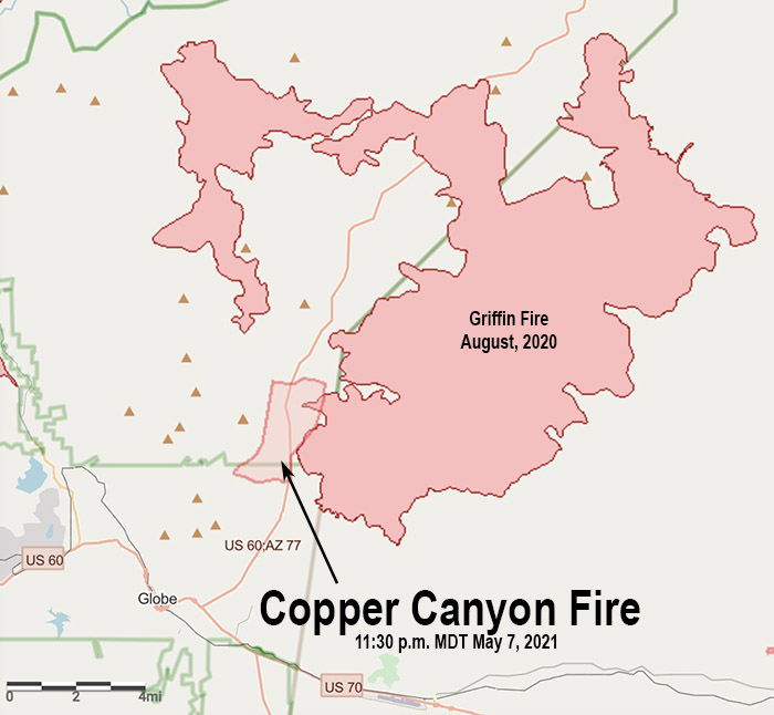
Map showing the approximate location of the Copper Canyon Fire 11:30 p.m. MDT May 7, 2021. A portion of it appears to have burned into the Griffin Fire of August, 2020.

The Copper Canyon Fire that started in dry vegetation at about 12:30 p.m. Friday was pushed northeast by strong winds. Eleven hours later it was mapped at 2,500 acres. A portion of the fire has burned into the footprint of the Griffin Fire that blackened over 61,800 acres in August of 2020. It has been running roughly parallel to Highway 60, which is now closed. There are about seven miles of open country ahead of it until the north and east sides become trapped in the area burned last year.

The Copper Canyon Fire is spreading toward ranches, mines, utility infrastructure, and local grazing allotments. Crews are actively engaged in structure protection for the potentially impacted properties. As of 1:52 a.m. on Saturday there were no evacuations in effect.

Aircraft including a Very Large Air Tanker (VLAT), a Large Air Tanker, Single Engine Air Tankers (SEATs), and Air Attack are assisting an estimated 100 fire personnel on the ground.

Friday night a weather station south of Globe detected 5 to 10 mph winds gusting out of the south and southwest at 10 to 15 mph. At 7:06 a.m. on Saturday it recorded 67 degrees, 14 percent relative humidity, and winds out of the east at 7 mph gusting to 13 mph. West to southwest winds are expected to become breezy to very breezy again during the afternoons on Saturday and Sunday with gusts generally reaching upwards of 20-25 mph. Minimum RH values will generally remain around 9-15%.

Copper Canyon Fire, May 7, 2020
Copper Canyon Fire, May 7, 2020. AZ State Forestry photo.
Copper Canyon Fire, May 7, 2020
Copper Canyon Fire, May 7, 2020. AZ State Forestry photo.


7 p.m. MDT May 7, 2021

Copper Canyon Fire
Map showing the location of heat detected by satellites over the Copper Canyon Fire at 2:54 p.m. MDT May 7, 2021.

The Copper Canyon Fire about 3 miles north of Globe, Arizona has forced the closure of Highway 60 north of the Highway 70 intersection. The fire is about 60 air miles east of Mesa.

At 5:58 p.m. MDT the Arizona Department of Forestry and Fire Management reported the fire had burned about 1,300 acres and had crossed Highway 60, forcing its closure.

Single engine air tankers and two larger air tankers, a DC-10 and an RJ85, have been seen working on the fire.

Copper Canyon Fire
Copper Canyon Fire crosses Hwy. 60, May 7, 2021; AZ State Forestry.
Copper Canyon Fire
Copper Canyon Fire, May 7, 2021. AZ State Forestry.
Copper Canyon Fire map
Aircraft over the Copper Canyon Fire at about 6:12 p.m. MDT May 7, 2021.

Three Rivers Fire in New Mexico grows to 6,000 acres

Eight miles northwest of Ruidoso

Updated at 9:45 a.m. MDT April 27, 2021

  1. Three Rivers Fire, map wyyyy ffednffn and Three Rivers Fire, map 4:30 p.m. MDT April 26, 2021.

The latest information available about the Three Rivers Fire in New Mexico is that as of Monday afternoon it had burned 6,100 acres, and was about 8 miles northwest of Ruidoso and six miles west of Sierra Vista.

The primary direction of spread is generally toward the northeast, but the right flank is also moving to the east.

(To see all articles on Wildfire Today about the Three Rivers Fire, including the most current, click here.)

As this is written at 8:12 a.m. on Tuesday the live camera at Ruidoso shows wet streets. The weather forecast for the fire area on Tuesday calls for a minor chance of light rain showers. Minimum relative humidities will remain between 25 and 30 percent with breezy 15 to 25 mph winds out of the southwest with gusts up to 35 mph. Temps will be below to well below average through Friday, then back above average this weekend.

Evacuations are still in effect for the Three Rivers Fire :

• Nogal Canyon Area
• Bonito Canyon Area
• Tanbark
• Church
• Ranchman’s Camp
• Loma Grande
• Cora Dutton
• Magado
• Ski Apache

Evacuation Centers
• Nazarean Church Camp, 200 Bonito Park Rd. Alto, NM 88316
• Capitan Senior Center at 412 Tiger Drive Capitan, NM 88316
• Ruidoso Downs Senior Center at 393 Highway 70 West Rd. Ruidoso Downs, NM 88346.

Three Rivers Fire, April 26, 2021. USFS photo. Three Rivers Fire, April 26, 2021. USFS photo.