Fire north of Dierks, Arkansas at 6:36 p.m. CT March 20, 2022. Photo by Bill Gabbert.
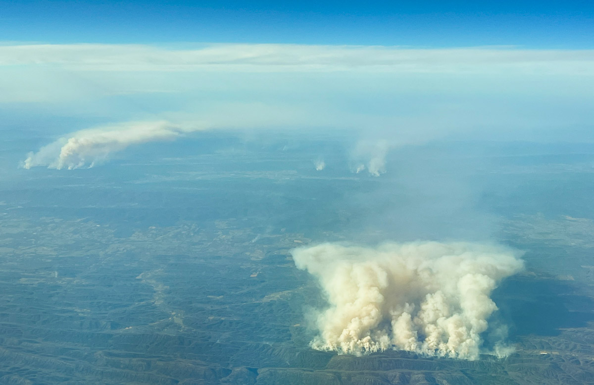
On a flight that took me over Arkansas today, March 20, there was quite of bit of fire activity in the western part of the state. From 30,000 feet it was impossible to tell if it came from prescribed fires or wildfires. The photo above was taken approximately 21 miles north-northeast of Dierks, looking north.
Heat detected by satellites, which may be the larger smoke in the photo, was long and narrow in an east-west direction, just north of Hurricane Knob.
A weather station north of the smoke on Sunday afternoon recorded 78 degrees, 17 percent RH, and 6 mph winds gusting out of the south-southwest at 10 to 14 mph.
There were numerous smaller smokes north and northwest of the ones seen in the photo.
The fire was approximately 18 miles southwest of Medicine Lodge
Tanker 95 makes a drop on the EWB fire in Barber County, Kansas March 25, 2020. From the Kansas Forest Service Facebook page.
Firefighters from 11 agencies battled a wildfire in southern Kansas on March 25 assisted by two UH-60 National Guard Blackhawk helicopters and a privately owned S-2 air tanker.
Kansas Governor Laura Kelly issued a disaster declaration for the EWB Fire burning in Barber County just north of the Oklahoma border about 18 miles southwest of Medicine Lodge.
“The declaration authorizes the use of state resources and personnel to assist with response and recovery operations in affected counties that meet certain criteria,” the governor’s office explained.
Wildfire Today’s very unofficial estimate of the size of the fire based on satellite detections of heat puts it at approximately 4,000 acres. By the end of the day firefighters had mostly stopped the spread of the fire.
Below is an excerpt from the Kansas Forest Service Facebook page, posted March 26, 2020.
Yesterday afternoon, Air Tanker 95, piloted by Bill Garrison, under contract with the Kansas Forest Service was assigned to the EWB Fire in Barber County. Air Tanker 95 made five drops on the EWB Fire with the support of KFS DFMO Bryce Haverkamp who tied in with the local incident commander. This fire brought back memories for many involved as it followed the burn scar from the Anderson Creek Fire of 2016. The collaborative efforts of many agencies and firefighters across the area prevented a wildfire from becoming what could have been a catastrophic wildfire. With social distancing, it may be a while before you are able to thank your local firefighters for their hard work on stopping the EWB Fire – so be sure to send them a text, give them a call, direct message on social media, or air five to thank them for everything they do to protect our Kansas communities.
Map showing heat on the EWB fire detected by a satellite at 2:55 p.m. CDT March 25, 2020. Wildfire Today.
Thanks and a tip of the hat go out to Matt. Typos or errors, report them HERE.
Fires also detected in eastern OK and southeast MO
At 4:14 p.m. CST the GOES 16 satellite detected fires and smoke in Arkansas, Oklahoma, and Missouri. NASA data, processed by Wildfire Today.
At 4:14 p.m. CST on March 5 the GOES 16 satellite detected fires and smoke in Arkansas, eastern Oklahoma, and southeast Missouri. It is difficult to tell if they are wildfires, prescribed fires, or agricultural burning, but most of them appear to in forested areas.
The March 5 prediction for Red Flag Warnings designated areas of enhanced wildfire danger north and northwest of Arkansas.
Firefighters with leaf blowers on the Chestnut Knob Fire. The fire is 6 miles south of Morganton, NC and at the last report grew by 9 acres. InciWeb.
While several large fires in the southern states are still actively spreading, firefighters have made progress on dozens of others.
On Monday the Southern Geographic Area reported 52 large uncontained fires, for a total of 133,146 acres. There were 185 new fires of all sizes for 1,477 acres; most of those were suppressed while still small. That was considered “moderate” initial attack activity.
Firefighting resources assigned in the South:
78 aircraft
83 hand crews
1,011 pieces of equipment
4,476 personnel
Map showing the location of some of the large fires in the southern states. The red dots represent heat detected by a satellite at 2:22 am November 21, 2016.
On Sunday evening four fires reported 24-hour growth of more than 100 acres:
Rock Mountain Fire
Map of the perimeter of the Rock Mountain Fire at 6 p.m. ET November 20, 2016.
The Rock Mountain Fire that started about 10 miles northwest of Clayton Georgia has spread north into North Carolina. At the last report it had burned 11,287 acres, an increase of 862 acres. On Sunday it was very active, moving through the hardwood leaf litter in all directions at a rate of about one mile each day. Evacuations are still in place for Dream Catcher Cove north of Tate City, Georgia.
On Saturday strong winds pushed the blaze across the Appalachian Trail on the north end of the fire. Winds blowing leaves still falling from trees are creating problems for firefighters, covering existing firelines and causing some areas to re-burn.
East Miller Cove
The East Miller Cove Fire is just east of Walland, Tennessee, 16 miles south of Knoxville. On Sunday evening the incident management team reported it had burned 1,492 acres, an increase of 1,292 acres, threatening 100 structures north of Great Smoky Mountains National Park.
Big Branch
The Big Branch Fire is in southeast Kentucky three miles south of Roxana and five miles northeast of Cumberland. It has burned 625 acres, an increase of 175 acres.
Oakwood 1 Fire
This fire is in Arkansas, listed at 468 acres, an increase of 278. No other information is available.
A firefighter on the Chestnut Knob Fire. InciWeb.
For the latest articles at Wildfire Today about how smoke from the wildfires is affecting various locations in the South, check out the articles tagged “smoke”.
The Arkansas Forestry Commission released their statistics for the number of acres burned in the state during the last six years. It turned out that the 14,652 acres in 2015 was the second fewest during that period, well below the average of 25,669.