Bushfires continue to burn in Tasmania

At least 26 bushfires are being fought by firefighters in Tasmania.

Photo above: Backburning near Arthur River in northwest Tasmania, January 29, 2016. Photo by W. Frey.

Bushfires that have been raging across northwest Tasmania for several weeks are still causing great concern in the island state south of Australia.

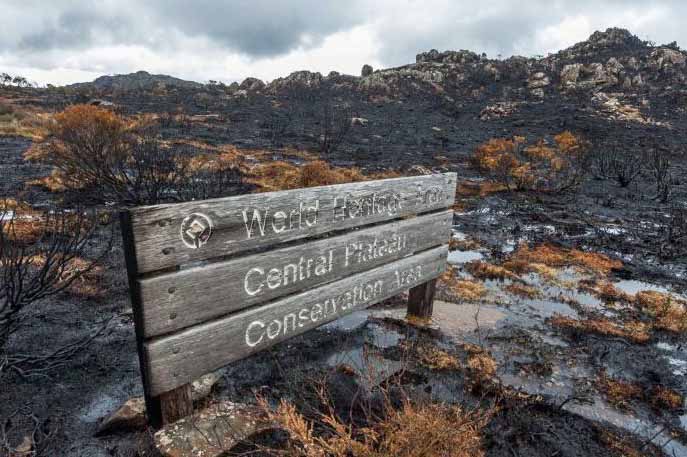
One of the fires in the Central Plateau has burned about 11,000 hectares (27,000 acres) in the World Heritage Area, about 1.2 percent of the WHA. Unique alpine flora such as pencil pines, king billy pines and cushion plants — some more than 1,000 years old — have been destroyed.
World Heritage site burned Tasmania
A burned area at a World Heritage site in Tasmania. Photo by Dan Broun.

The New South Wales Rural Fire Service has sent many of their wildland firefighters across the Bass Strait to assist their neighbors in Tasmania.
NSW RFS firefighters Tasmania
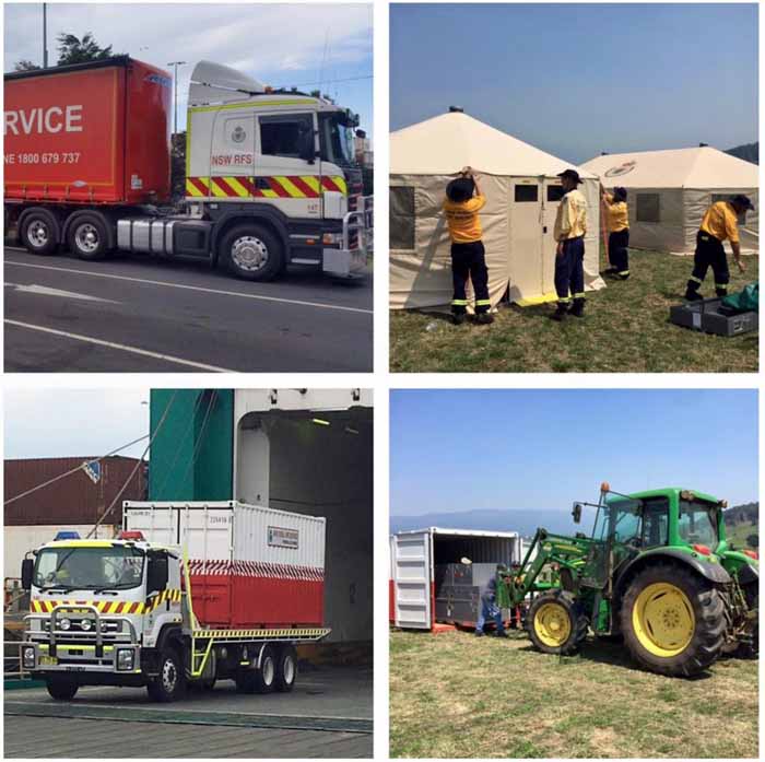
The New South Wales Rural Fire Service has sent a great deal of aid to assist with the fires in Tasmania. In these photos equipment is arriving to set up a camp capable of sleeping 150 firefighters at Moles Creek. Next week more firefighters and fire engines will be mobilized to Tasmania. NWS RFS photos.

Three air tankers from North America that have been working in Australia during their summer bushfire season have also been deployed, including a DC-10, Avro RJ85, and a C-130. This may be the first time these large aerial firefighting resources have been used in Tasmania. The Fire Service felt it was necessary to warn the residents to “not be alarmed” when they saw the air tankers “flying a bit low over the coast”. More information about the air tankers in Tasmania is at Fire Aviation.

DC-10 air tanker Tasmania
A DC-10 air tanker being used to fight wildfires in Tasmania. Photo by Tasmania Fire Service.

Most of the most active bushfires are in the northwest part of Tasmania. Three of the largest are in these areas:

  • Arthur River and Nelson Bay. 21,000 hectares (52,000 acres).
  • Pipeland Road. 62,000 hectares (153,000 acres).
  • Lake Mackenzie Road. 25,000 hectares (68,000 acres).

Another fire in the southwest part of the state has burned 4,000 hectares (10,000 acres) between Lake Gordon and Lake Pedder.

At least 26 bushfires are still active while 48 others have been contained.

Below are maps showing the locations of the fires, and more photos.

Continue reading “Bushfires continue to burn in Tasmania”

U.S. and Australia loaning each other Incident Meteorologists

From KPQ News:

“An innovative and international approach to fighting wildfires is underway with specialty meteorologists lending their skills both in Washington and in Australia.

Incident Meteorologist
An Incident Meteorologist at a wildland fire. File photo from NOAA.

The program takes four specialty forecasters called Incident Meteorologists from the Spokane office and sends them to Australia for weeks at a time, lending skills to help firefighters tamp down wildfires as ferocious as we see across the West. Only 85 Incident Meteorlogist specalists exist in the entire United States. Meteorologist John Fox has just returned from a several week stint in Australia trading the latest wildfire-fighting forecasting skills with the Aussies. One of the Spokane incident meterologists is stationed in Adelaide Australia right now.”

Concerns raised about the choice to lead an inquiry into fatal bushfire in Western Australia

The government of Western Australia is conducting an inquiry into the Waroona Bushfire that in early January, 2016 killed two people, burned 31,000 hectares (76,600 acres), and destroyed 95 homes near Yarloop. Some of the residents were evacuated by boat after they found themselves trapped between the Indian Ocean and the fire.

Below is an excerpt from an article in The Australian:

The man appointed to lead an ­independent inquiry into the ­Yarloop bushfire, Euan Ferguson, ran South Australia’s rural fire service when it was heavily criticised in a coronial report for failing to warn the public about a fire that killed nine people in 2005.

The finding is relevant because Mr Ferguson is now examining complaints from angry Yarloop residents that they also were not adequately warned about the blaze last month in which two people died.

Mr Ferguson was in charge of the Country Fire Service during the so-called Black Tuesday bushfire in Port Lincoln that destroyed 93 homes and wiped out 77,000ha of land [in 2005].

South Australia’s deputy coroner, Anthony Schapel, found the CFS under Mr Ferguson failed to adequately warn the public when the fire began and did not adequately respond to the fire.

“The community to the southeast and east of the fireground were unaware of the risk of the fire in many instances until it was too late,” Mr Schapel found in 2007.

“The fact of the matter was that no adequate measures were put in place or attempted which meant that opportunities to alter the outcome were not taken.

“Because the risk to the public was never properly addressed or appreciated, none of those measures were ever adequately considered. For the same reason no adequate warning was given.”

Yarloop residents say Western Australia’s Department of Fire and Emergency Services failed to convey the danger they faced before the deadly bushfire destroyed their town on January 7.

The department did not issue its first emergency warning that explicitly mentioned Yarloop until 7.35pm — just minutes before the fire hit…

Did humans learn how to use fire as a management tool from birds?

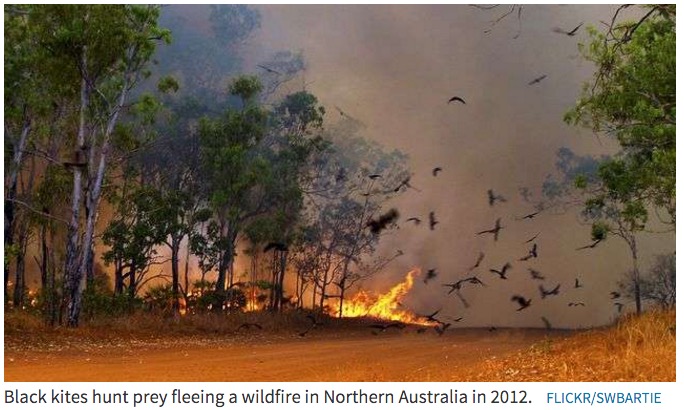
It is thought that birds in northern Australia help spread wildfire by carrying burning twigs.

On 16 occasions in the past we have jokingly used the term “animal arson” when a critter played a part in starting a fire. Examples include a mouse chewing through a power cord (and for a while was thought guilty of manslaughter), a dog chewing on strike-anywhere matches, a pigeon and a sparrow carrying lit cigarettes to their nests, a bird dropping a fish onto a power line, and a bird’s wings contacting two power lines.

Black kite in Bangalore, India. Photo by Yathin S. Krishnappa.

There may be more to this than we originally thought. Researchers have documented multiple instances of anecdotal evidence leading to the belief that birds have helped spread wildfires in Australia’s Northern Territory. There are two primary suspects, the black kite, Milvus migrans and brown falcon, Falco berigora, but other birds of interest are the grasshopper buzzard, Butastur rufipennis in central Africa, and the crested caracara, Caracara cheriway in the southern United States.

Black Kites are found on four continents, but not in North or South America. They feed on small live prey, fish, lizards, carrion, large insects, and have been known to take birds, bats, and rodents. They are attracted to vegetation fires and will fly in from miles away to dine on small animals escaping the flames.

Black Kites fire prey

They like it so much that it is believed they keep the fire going by picking up burning twigs in their claws and carrying it some distance to a patch of unburned vegetation. They will wait with their feathered friends until the fire gets going and their table is set, and then grab the scurrying critters. If the fire slows down too much in that area, the story goes, they will find another burning twig to propagate the fire again.

There is also an account of a black kite dropping bread in a river. When fish congregated around the bait, the kite dived in for a meal. It is not a huge stretch from using bread as bait to carrying fire in order to herd small animals.

The evidence to support this behavior is all anecdotal, but it has aroused the interest of scientists Bob Gosford and Mark Bonta who presented some of their preliminary research on this issue at the Raptor Research Foundation meeting in Sacramento, California November 8, 2015. Their presentation included this theory:

It is also possible that humanity’s acquisition and manipulation of fire may be a result of the observation of intentional avian pyrophilic behaviour rather than solely from some relationship with lightning-caused fire.

Articles on Wildfire Today tagged “animal arson“.

Bushfire threatens coastal towns in northwest Tasmania

Some evacuation routes may be cut off by the fire.

Northwest Tas bushfire 1325 UTC Jan 25 2016
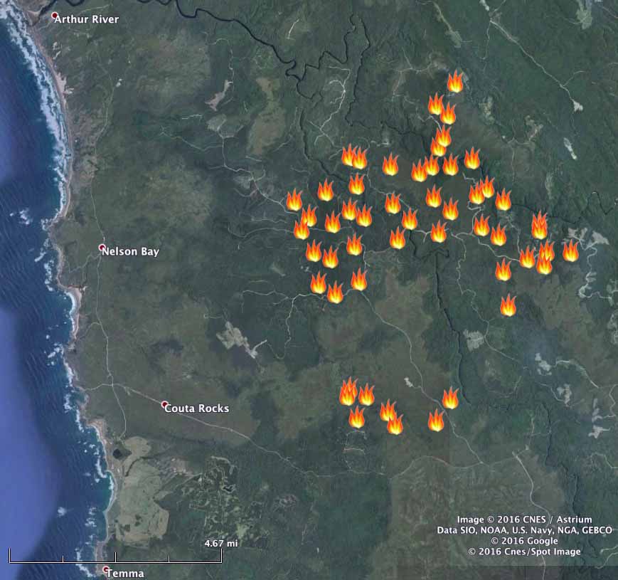
The icons represent heat detected by a satellite at 1:25 p.m. UTC, January 25, 2015.

Residents in some coastal towns in northwest Tasmania, Australia have been advised to evacuate as a bushfire spreads closer to the communities. The fire is within four to eight miles (6 to 12 km) of Arthur River, Nelson Bay, Couta Rocks, and Temma.

The Tasmania Fire Service warned at 6:52 a.m. local time on January 27 that Nelson Bay and Temma were “at high risk NOW”, advising that “burning embers … will threaten your home before the main fire”.

Residents from Temma and Couta Rocks may not be able to travel north to their evacuation center. The TFS said “there is a nearby safer place at the beach”.

Firefighters in Tasmania battling numerous fires

More than 50 fires are burning uncontrolled across Tasmaina in Australia.

Map of fires in Tasmania
Map of fires in Tasmania.

Firefighters in Tasmania have had their hands full in recent days dealing with a rash of fires burning across the island state south of the Australian mainland. More than 42,000 hectares (103,000 acres) have burned in the past 10 days.

At least partially due to moderating weather, all of the fires are now at the “Advice” warning level or lower, meaning people in the area should keep up to date with developments, but there is no immediate need to start taking action or to evacuate.

Approximately 100 firefighters from New South Wales and Victoria on the Australian mainland will travel to Tasmania Saturday to assist with the fires. Equipment, including two firefighting helicopters from New South Wales, is already on its way. NSW is also sending an 18-person Incident Management Team.

One of the larger fires has burned almost 18,000 hectares (44,000 acres) 28 kilometers (17 miles) south of Smithton in the general vicinity of Sumac Road, Dempster Plains, and Temma. Parts of the fire have not spread recently but the western, northern and southern edges remain active. There has been a run from the northeast corner through the Luncheon Hill area. The fire is east of the Western Explorer Road and has crossed Tarkine Wilderness Drive. Crews are working in the northwest area of the fire to protect forests assets.

fires in Tasmania