Above: The image shows heat detected by a satellite August 31 and September 1, 2017. The red dots are the most recent, early Friday morning.
The Diamond Creek Fire in the Pasayten Wilderness in the Okanogan/Wenatchee National Forest has crossed the Washington/British Columbia border and spread three miles into Canada. The Incident Management Team reports the total size of the fire is over 52,000 acres.
Jon Large was coming back from a fire in British Columbia on July 26, 2017 with a Parks Canada team and while at a debrief in Kamloops grabbed these photos. Thanks Jon!
Above: Map showing heat detected by a satellite in southern British Columbia at 2:51 a.m. MDT August 9, 2017.
(Updated at 5 p.m. MDT August 9, 2017)
The wildfire situation in British Columbia has not gotten any better in the last several days. Currently there are 128 active wildfires in the province, with four of them being larger than 50,000 hectares (123,000 acres). The largest, the Hanceville Riske Creek Fire, is getting closer to half a million acres each day.
Since April 1, approximately 591,280 hectares (1,461,082 acres) have burned in 900 fires in BC.
Hanceville Riske Creek, 172,000 hectares (425,000 acres) approximately 60 km southwest of Williams Lake.
Elephant Hill, 117,000 hectares (289,000 acres), near Ashcroft.
Tautri Lake, 76,000 hectares (188,000 acres), 80 km northwest of Williams Lake.
More than 400 additional firefighters from Australia, New Zealand, Mexico and the US are expected to arrive in BC this week. Other firefighters from Australia have been in the province for a couple of weeks. More than 100 firefighters arrived from Mexico since Saturday of last week. No resources have been ordered or dispatched to Canada through the United States National Interagency Coordination Center, but the Great Lakes Interstate Forest Fire Compact mobilized a crew to Ontario that is now in British Columbia, and Massachusetts sent personnel across the border. Of course the northwestern one-quarter of the United States is pretty busy with their own fires.
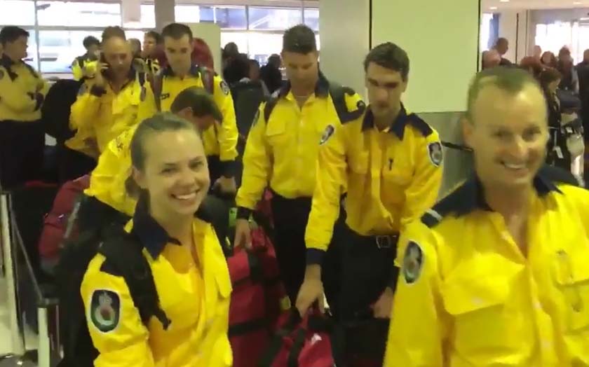
Firefighters from Massachusetts board an aircraft on the way to the Elephant Hill Fire near Ashcroft, British Columbia. Photo by Mass. Department of Conservation and Recreation. On Tuesday U.S. time 40 firefighters from Australia’s New South Wales Rural Fire Service joined 60 others from across the continent as they began their travel to British Columbia. Screenshot from NSWRFS video.
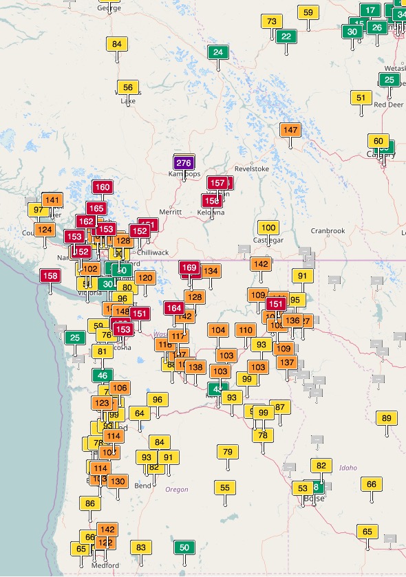
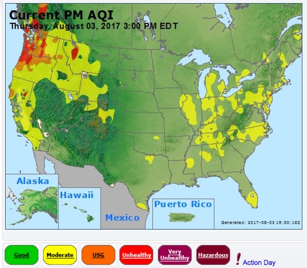
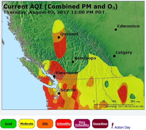
Smoke from wildfires in British Columbia, Washington, Oregon, Idaho, and Montana has created seriously degraded air quality off and on in those areas, at times reaching the “unhealthy” level according to air quality officials.
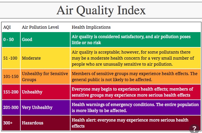
Air quality, southern BC, Washington, and Oregon. Legend for the above Air Quality map.
40 #NSWRFS members will form part of a 100 strong frontline firefighting team heading to #Canada today to assist with #BCfires. pic.twitter.com/jLH6XErcxP
Above: Satellite photo of smoke from wildfires in the U.S. Northwest and Southern British Columbia, August 5, 2017. The red dots represent heat detected by the satellite.
(Updated at 6:50 p.m. MDT August 5, 2017 to add the more current satellite photo above.)
Smoke from wildfires in Southern British Columbia continues to pour across the border into Washington and other states in the U.S. Northwest. The air quality in Washington is the worst that residents have seen in recent years, reaching unhealthy levels in some areas according to agencies that monitor particulates and other pollutants.
Currently there are 110 active wildfires in British Columbia — four of them are larger than 50,000 hectares (123,000 acres):
Hanceville Riske Creek, 148,000 hectares (365,000 acres) approximately 60 km southwest of Williams Lake.
Elephant Hill, 110,000 hectares (272,000 acres), near Ashcroft.
Tautri Lake, 73,000 hectares (180,000 acres), 80 km northwest of Williams Lake.
Below is a gallery of maps and graphics showing the location of the fires, air quality, and smoke. Click on an image to see a larger version and start a slide show. Captions are in the top-left corner.
Above: The distribution of wildfire smoke, current as of 2:09 p.m. MDT August 3, 2017.
(Originally published at 2:50 p.m. MDT August 3, 2017)
Smoke from wildfires in the United States Northwest and southern British Columbia is accumulating in those areas causing, in some areas, significant degradations in air quality. In British Columbia many massive fires combined with light winds has resulted in the smoke not being transported out of the area.
Air quality August 3, 2017 for western Canada and parts of Washington, Idaho, and Montana.
Some areas in BC, western Montana, and the western portions of Washington and Oregon have “unhealthy” air quality today, according to Air Now.
Above: Satellite photo taken August 2, 2017 showing smoke from some of the wildfires in British Columbia. The red dots represent heat detected by a sensor on the satellite
(Originally published at 9:50 p.m. MDT August 2, 2017)
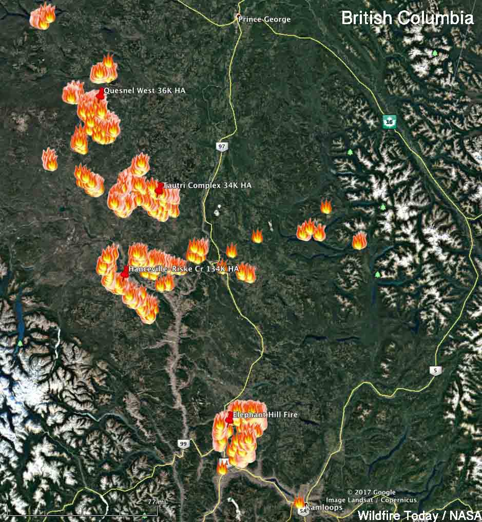
Firefighters in British Columbia are dealing with over 100 wildfires that are larger than 0.01 hectare. The location for four of the largest can be seen on the map below which shows heat detected by a satellite on Wednesday.
Map showing heat from fires in British Columbia detected by a satellite at 3:12 p.m. MDT August 2, 2017. Click to enlarge.
Here are very brief of summaries of four of the largest fires:
Hanceville-Riske Creek, 60 kilometers southwest of Williams Lake. The Hanceville and the Riske Creek Fires are being managed as one. Together they have burned 134,000 hectares (331,000 acres).
Quesnel West, 4 km north of the Baezaeko River. 36,000 HA (88,000 acres).
Tautri Complex, 85 km northwest of Williams Lake. 64,000 HA (84,000 acres).
Elephant Hill, near Ashcroft. 84,000 HA. (207,000 acres).
The weather forecast for Ashcroft near the Elephant Hill fire looks grim for firefighters — over 100F every day for the next week with the relative humidity around 20 percent or below. It looks better for Williams Lake with highs in the high 80’s and low 90’s with the relative humidity in the mid-20’s.
File photo of an Air Tractor 802-F. Air Tractor photo.
The investigators concluded that a wing stalled either independently or in combination with an encounter with a wing-tip vortex generated by another aircraft.
Below is the TSB’s Summary of the incident:
An Air Tractor AT-802A on amphibious floats (registration C-GXNX, serial number AT- 802A-0530), operating as Tanker 685, was carrying out wildfire management operations during daylight near Chantslar Lake, British Columbia. Three similar aircraft were working as a group with Tanker 685, which was second in line on a touch-and-go to scoop water from Chantslar Lake. Upon liftoff, control was lost and the aircraft’s right wing struck the water. The aircraft water-looped, and the floats and their support structure separated from the fuselage. The aircraft remained upright and slowly sank.
The pilot received minor injuries, egressed from the cockpit, and inflated the personal flotation device being worn. The third aircraft in the formation jettisoned its hopper load as it continued its takeoff and remained in the circuit. The fourth aircraft jettisoned its hopper load, rejected its takeoff, and taxied to pick up the accident pilot. There was sufficient impact force to activate the on-board 406- megahertz emergency locator transmitter, but the search-and-rescue satellite system did not detect a signal from the emergency locator transmitter until the wreckage was being recovered 6 days later.
The TSB’s findings, in part:
1. A wing stalled either independently or in combination with an encounter with a wing-tip vortex generated by the lead aircraft. This caused a loss of control moments after liftoff, and resulted in the right-hand wing tip contacting the water and in a subsequent water-loop.
2. The operator’s standard takeoff procedures did not specify a liftoff speed for scooping operations. Lifting off below the published power-off stall speed contributed to a loss of control at an altitude insufficient to permit a recovery.
3. The takeoff condition, with the aircraft heavy, its speed below the published power-off stall speed, and a high angle-of-attack contributed to the loss of control.
4. An understaffed management structure during organizational changes likely led to excessive workload for existing managers. This contributed to risks, contained within the standard operating procedures, not being addressed through the operator’s safety management system, resulting in continued aircraft operations below published minimum airspeed limitations.
The report states that Conair hired a safety manager and a company check pilot for the Fire Boss fleet before the 2015 spring training season started. And, Conair adopted a risk mitigation plan for 2015–2016, applicable to the company’s AT-802 fleet. The plan addresses issues mentioned in the TSB report, plus an additional issue identified in-house.
The year following the August 14, 2014 crash on Chantslar Lake there were three incidents that we are aware of that involved Conair AT-802’s:
2015, April 11: An engine failure on Air Tanker 699, an Air Tractor AT-802A, during training resulted in damage to a float upon landing. The incident occurred April 11, 2015 on Harrison Lake, BC, 33 nm NNE of Abbotsford.