British Columbia initiates wildland firefighter health research

Above: Firefighters in a smoky environment on the White Tail Fire, March 8, 2019, Black Hills National Forest.

Information from the British Columbia Wildfire Service:

VICTORIA – The BC Wildfire Service has provided $305,000 to help fund two research projects looking into the health and wellness of firefighters and associated personnel. The University of Northern British Columbia and the University of Alberta are conducting these studies to learn more about how firefighting activities affect the health of fire crews.

“Our firefighters have worked hard on the front lines to keep British Columbians safe during difficult and record-setting wildfire seasons,” said Doug Donaldson, Minister of Forests, Lands, Natural Resource Operations and Rural Development. “These studies will help us support their long-term health and well-being.”

Research by the University of Northern British Columbia is led by Chelsea Pelletier, PhD, who is an assistant professor with the School of Health Sciences at the University of Northern British Columbia.

A scoping review will:

  • Look holistically at the existing body of research and knowledge about wildland firefighter health and wellness (including its physical, mental and emotional dimensions) by conducting a global scan of the scientific literature;
  • Identify any modifications (based on the scientific literature and work done by wildfire management agencies elsewhere) that could be implemented in the short term to reduce potential health impacts; and
  • Identify any gaps in the work-related health knowledge of wildland firefighters and associated personnel.

The outcomes of this project and other information will help the BC Wildfire Service establish a long-term research strategy for worker health. This research is expected to be completed in the summer of 2020.

Research by the University of Alberta is led by Nicola Cherry, MD, PhD, who is the tripartite chair of occupational health with the Division of Preventive Medicine at the University of Alberta.

It is also supported by the Alberta government and aims to:

  • Examine the nature and concentration of polycyclic aromatic hydrocarbons in the air that firefighters breathe and accumulate on their skin (polycyclic aromatic hydrocarbons are a suite of organic compounds produced when organic material burns, some of which can be hazardous to human health);
  • Explore the practicality and effectiveness of firefighters using respiratory protective equipment; and
  • Investigate whether wildland firefighters have more chronic lung disease than other people of the same age, gender and geographic location.

So far, about 50 BC Wildfire Service firefighters have taken part in this study. Alberta firefighters are also participating. A progress report on the initial phase of this project should be released in March 2020.
Increased wildfire activity predicted for British Columbia and Yukon

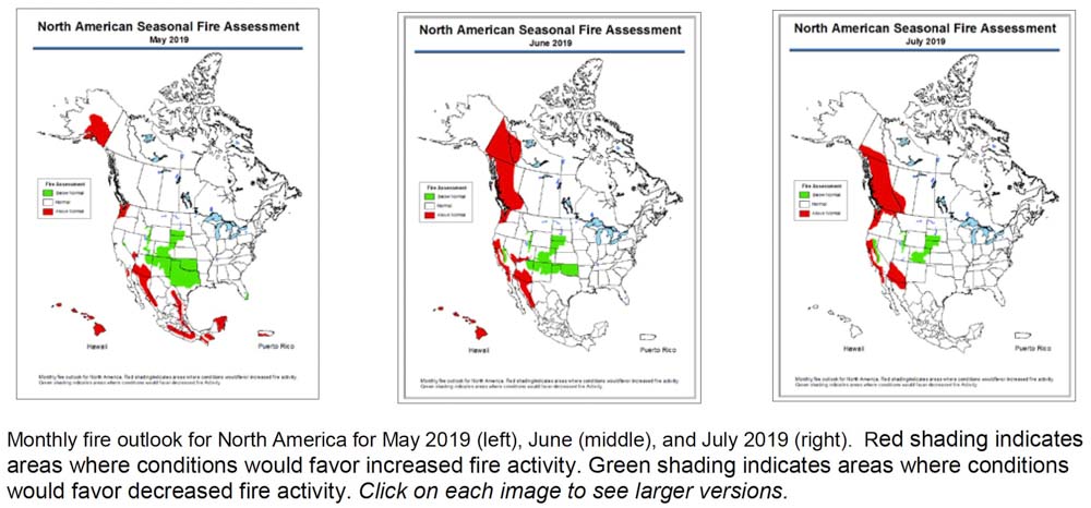
Wildfire potential for North America May, June, July, 2019
Wildfire potential for North America May, June, July, 2019. Click to enlarge.

The Predictive Services section at the National Interagency Fire Center has predicted above normal wildfire activity  this summer for southern Arizona, areas of California, and western Oregon and Washington.

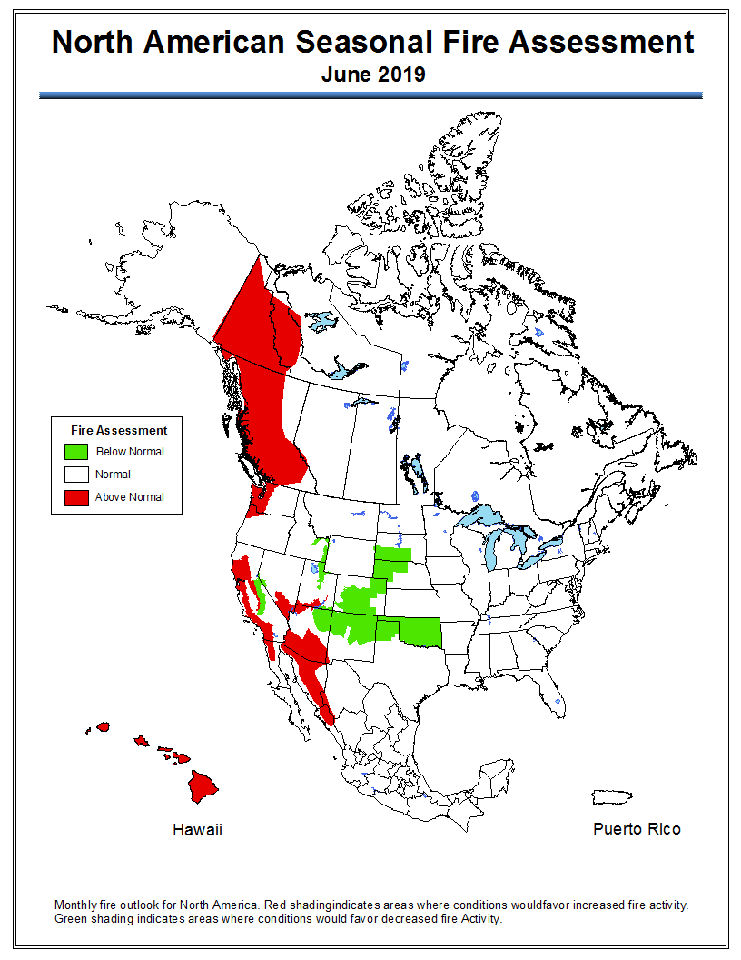
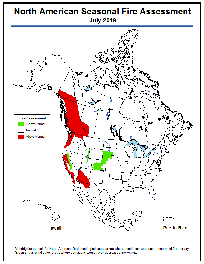
An outlook for North America released on Friday also shows enhanced potential for British Columbia and the Yukon Territory in June and July.

Below is an excerpt from the North American Seasonal Fire Assessment and Outlook prepared by NIFC, Natural Resources Canada, and Servicio Meteorológico Nacional.

“For May, recent climate model runs suggest Canada will have lower fire severity than normal. While an early start to warm and dry conditions is leaving much of British Columbia prone to fire starts, rainfall is likely in the last half of the month, which will likely result in normal monthly fire severity for the province. The latest climate model runs hint at continued blocking ridges in the eastern Pacific during June, resulting in warm and dry conditions and resulting elevated fire severity indexes in British Columbia and Yukon. This pattern often features the eastern side of the ridge over the Prairies, so western Alberta also appears prone to elevated fire risk, while conditions east of Alberta are likely to have normal values. July’s forecast is similar to June’s forecast, with elevated fire severity indexes expected throughout British Columbia, western Alberta, and southern Yukon. A slight difference exists as the Yukon area depicted covers only the southern part of the territory in July, while in June it extended north near the Arctic coast.”

Wildfire potential for North America, May
Wildfire potential for North America, May 2019.
Wildfire potential for North America, June
Wildfire potential for North America, June 2019.
Wildfire potential for North America
Wildfire potential for North America, July 2019.

Plane crash kills three while mapping fires in B.C.

A small plane checking a fire that burned last year crashed in British Columbia Saturday May 4 killing three occupants. The pilot of the single engine Cessna 182 and two passengers died in the accident while one passenger survived and is being treated after being flown to a Vancouver hospital by a Joint Rescue Coordination Centre helicopter.

Precision Vectors was under contract to the British Columbia Wildfire Service to use airborne infrared equipment to check fires from 2018 for residual holdover heat that persisted through the winter. Two of the deceased have been identified, both affiliated with the company — Lorne Borgal the CEO and founder of Precision Vectors, and Amir Ilya Sedghi who provided data analysis.

The Transportation Safety Board confirmed that the aircraft went down about 57 miles north of Smithers, B.C.

Our sincere condolences go out to the families, friends, and coworkers.

Three killed in plane crash while mapping fire in B.C.

A small plane checking a fire that burned last year crashed in British Columbia Saturday May 4 killing three occupants. The pilot of the single engine Cessna 182 and two passengers died in the accident while one passenger survived and is being treated after being flown to a Vancouver hospital by a Joint Rescue Coordination Centre helicopter.

Precision Vectors was under contract to the British Columbia Wildfire Service to use airborne infrared equipment to check fires from 2018 for residual holdover heat that persisted through the winter. Two of the deceased have been identified, both affiliated with the company — Lorne Borgal the CEO and founder of Precision Vectors, and Amir Ilya Sedghi who provided data analysis.

The Transportation Safety Board confirmed that the aircraft went down about 57 miles north of Smithers, B.C.

Our sincere condolences go out to the families, friends, and coworkers.

A fire in steep terrain

fire North Klinaklini River

Above: photo by BC Wildfire Service

The British Columbia Wildfire Service reports that this 8 hectare (20 acre) fire is burning in steep terrain by the headwaters of the North Klinaklini River. They have assessed the lightning caused fire and will monitor the growth within natural boundaries. No communities are threatened, they said.

Smoke produced by large wildfires can be equal to a volcano

Satellite photo fires British Columbia

Above: Satellite photo taken August 2, 2017 showing smoke from some of the wildfires in British Columbia. The red dots represent heat detected by a sensor on the satellite.

It is not easy to measure and quantify the composition of the smoke and the amount of particulate matter that a huge wildfire produces when intense, large-scale burning forms towering pyrocumulus clouds that climb tens of thousands of feet into the sky. This launches the byproducts of combustion into the  stratosphere — the second layer of Earth’s atmosphere, above the troposphere. Once introduced at that level they have been tracked while circling the planet multiple times.

Below is an excerpt from an article by Megan Gannon at Live Science, which points out similarities between large wildfire events and volcanos.

For comparison, the explosive 2008 eruption of Mount Kasatochi, an island volcano in Alaska, sent about 0.7 to 0.9 teragrams (nearly 1 million tons) of aerosols — tiny, suspended particles — into the stratosphere, Peterson said. For months afterward, people around the Northern Hemisphere documented unusually colored sunsets, thanks to the sulfate aerosols and ash the volcano injected into the atmosphere.

Peterson’s team estimated that the British Columbia pyroCb event sent about 0.1 to 0.3 teragrams (about 200,000 tons) of aerosols into the stratosphere — which is comparable to the amount seen with a moderate volcanic event, and more than the total stratospheric impact of the entire 2013 fire season in North America, he said.

It’s well known that catastrophic volcanoes can influence the global climate. The huge 1991 eruption of Mount Pinatubo in the Philippines, one of the largest in living memory, lowered temperatures around the world by an average of 0.9 degrees Fahrenheit (0.5 degrees Celsius).

As an example of the wildfire activity in British Columbia last year, here is an excerpt from an article posted August 9 at Wildfire Today:

The wildfire situation in British Columbia has not gotten any better in the last several days. Currently there are 128 active wildfires in the province, with four of them being larger than 50,000 hectares (123,000 acres). The largest, the Hanceville Riske Creek Fire, is getting closer to half a million acres each day.

Since April 1, approximately 591,280 hectares (1,461,082 acres) have burned in 900 fires in BC.

  • Hanceville Riske Creek, 172,000 hectares (425,000 acres) approximately 60 km southwest of Williams Lake.
  • Elephant Hill, 117,000 hectares (289,000 acres), near Ashcroft.
  • Tautri Lake, 76,000 hectares (188,000 acres), 80 km northwest of Williams Lake.
  • Baezaeko River-Quesnel West, 53,000 hectares (131,000 acres).

More than 400 additional firefighters from Australia, New Zealand, Mexico and the US are expected to arrive in BC this week. Other firefighters from Australia have been in the province for a couple of weeks. More than 100 firefighters arrived from Mexico since Saturday of last week…


It is burning season in British Columbia

BC burn registrations map

The map above shows the number of current registrations for Category 3 open fires in British Columbia. Registrations are required for a fire that burns material in piles larger than two meters high and three meters wide, windrows, or grass over an area larger than 0.2 hectares (0.49 acres) in size.

Most areas in southern British Columbia are expecting to receive precipitation over the next couple of days, so landowners are probably wanting to get the burns in before the rain or snow.

The BC Wildfire Service sent out a notice Friday morning saying, “Burn Registration line is currently receiving a high volume of calls. Pls be patient if you are waiting in queue.”

bc weather forecast