Southern California firefighters being tested by record heat and windy conditions

On Saturday there is a slight chance of isolated dry lightning strikes across the eastern San Gabriel Mountains during Red Flag Warning conditions

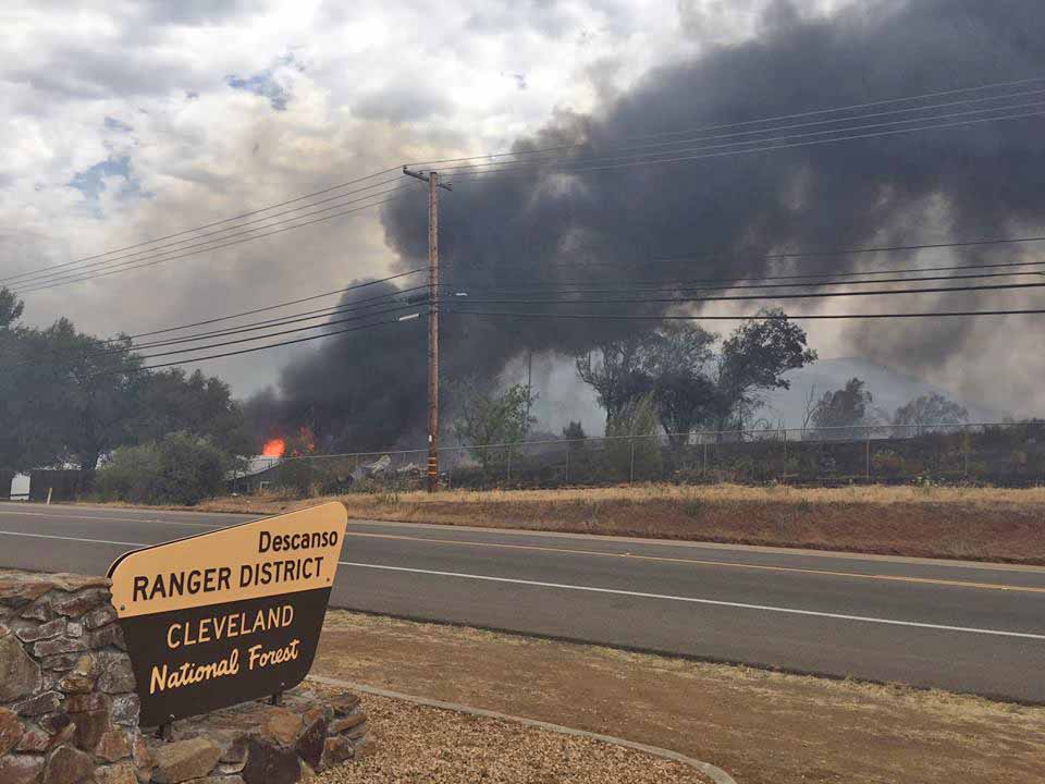
Above: Photo taken from the back yard of the USFS District Office in Alpine, CA during the West Fire July 6, 2018. USFS photo.

(Originally published at 9:20 a.m. PDT July 7, 2018)

The predictions for record heat in Southern California were accurate Friday as high temperatures soared into the triple digits. In downtown Los Angeles the old record for the date was broken by 10:15 a.m. when it hit the previous mark set in 1992 of 94 degrees. By the end of the day it was 108. The temperature at UCLA reached 111 degrees, the hottest temperature ever recorded there.

Other record-setting daily temperatures Friday in Southern California:

  • 117 – Van Nuys Airport
  • 114 – Burbank Airport
  • 115 – Ramona
  • 118 – Riverside

Firefighters were challenged by not only the heat but dry winds as fires broke out in several areas.

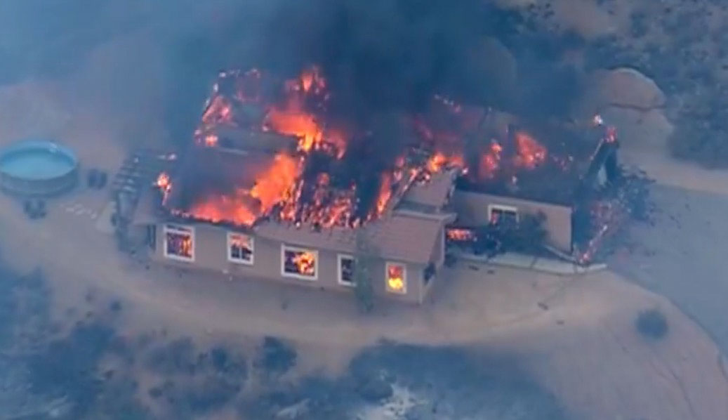
As the temperature reached 109 degrees, U.S. Forest Service firefighters on the Cleveland National Forest found themselves in a structure defense mode at their District Office in Alpine, with the West Fire adjacent to the building’s back yard and the rest of the 400-acre blaze across the street. Live footage shot by a local TV station showed numerous structures were destroyed.
forest service district office fire
Photo taken from the front yard of the USFS District Office in Alpine, CA during the West Fire. USFS photo.

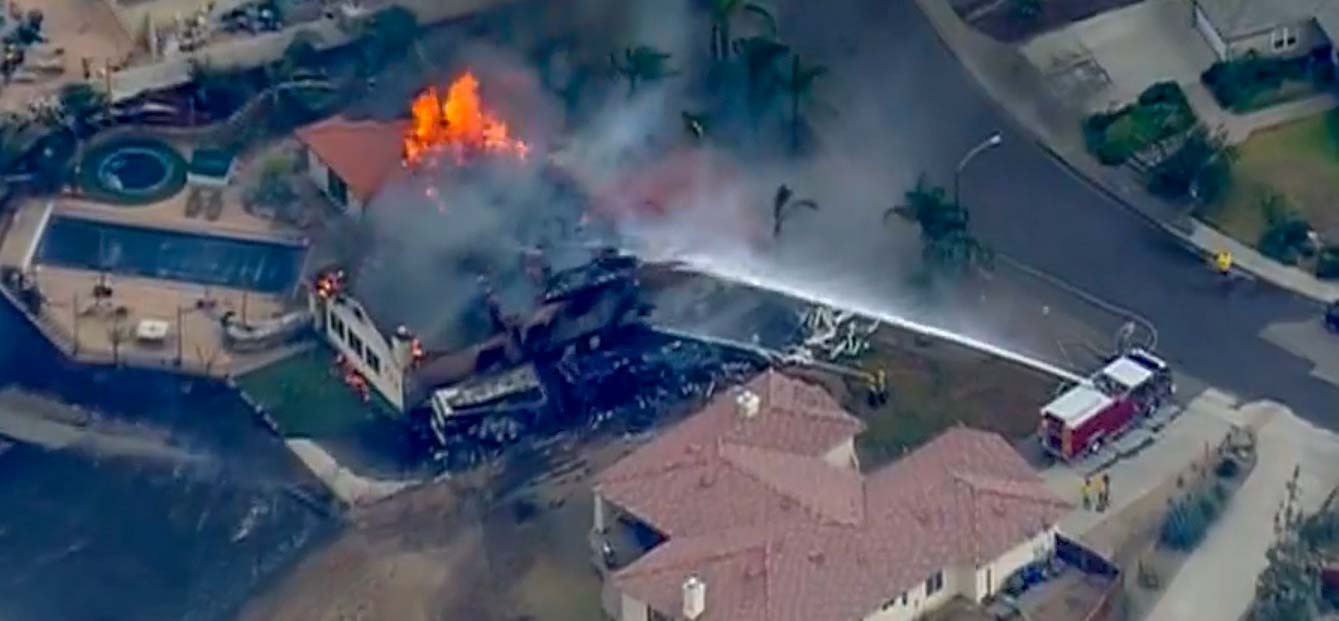
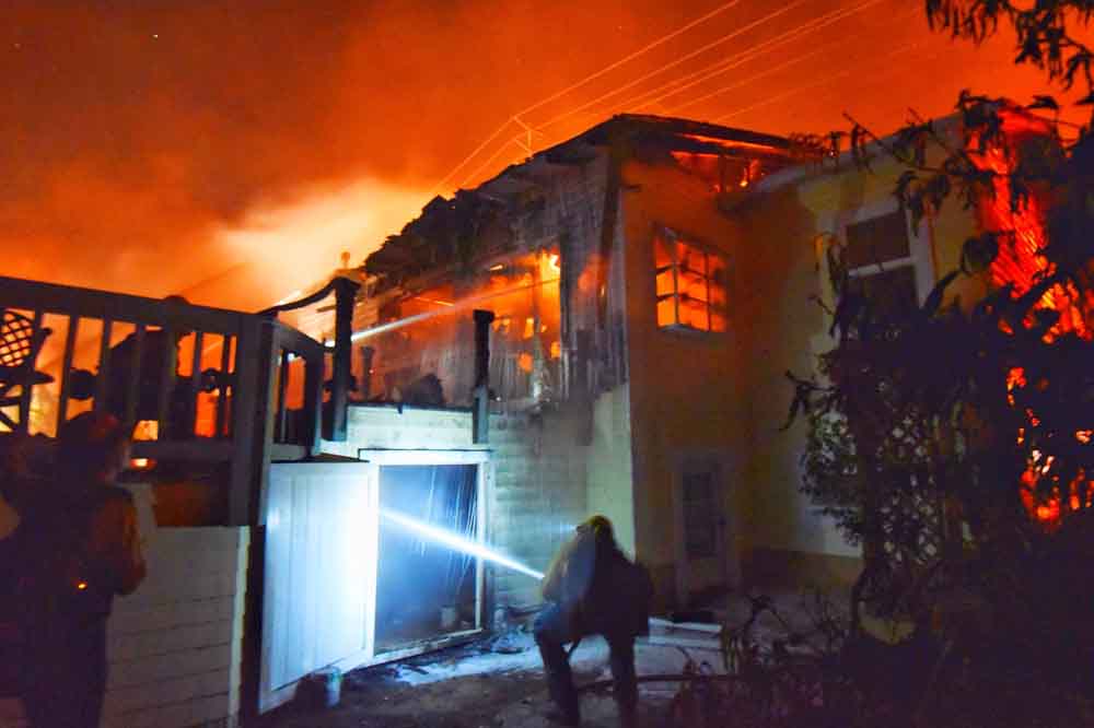
On the Santa Barbara coast sundowner winds pushed the Holiday Fire through the hills above Goleta, burning 10 to 20 homes according to fire authorities. Even into the night temperatures at the fire scene remained above 100 degrees.
holiday fire goleta
At the Holiday Fire, Santa Barbara County Fire Department firefighters apply water at a home off Fairview Avenue in Goleta. SBFD photo.

The Valley Fire that started Friday has burned at least 1,000 acres near Highway 38 on the San Bernardino National Forest. At last report it was headed into the San Gorgonio Wilderness Area. Mandatory evacuation are in effect for the Forest Falls Community east of the highway. Southern California Incident Management Team 2 will be assuming command.

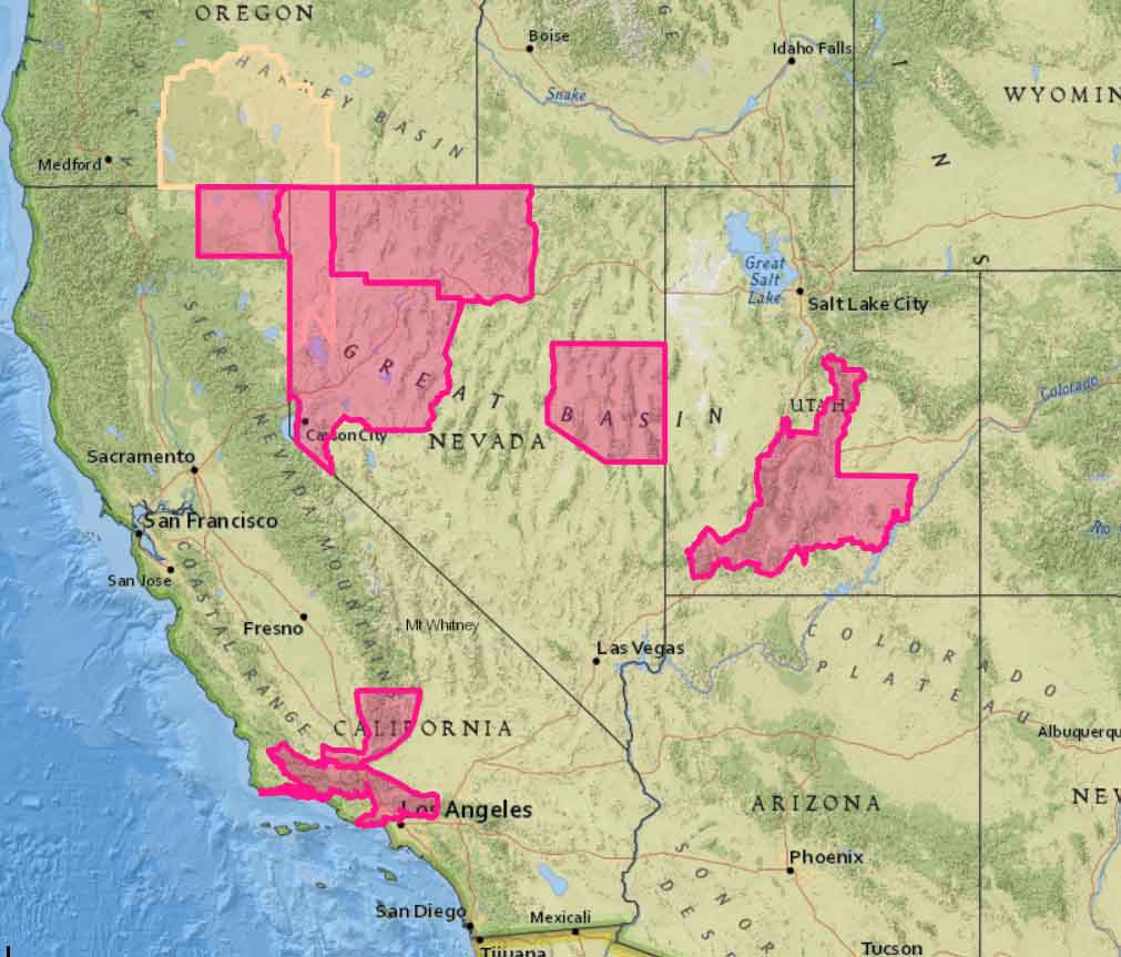
Much of Southern California is again under a Red Flag Warning Saturday as the huge high pressure dome lingers over the area, bringing more of the same very high temperatures, 2 to 8 percent relative humidities, and gusty winds.

And just to make the situation more interesting, there is a slight chance of isolated dry lightning strikes across the eastern San Gabriel Mountains along with thunderstorm-driven winds.
map Red Flag Warnings, July 7, 2018
Red Flag Warnings, July 7, 2018.

West Fire burns numerous structures at Alpine, California

Above: The West Fire at Alpine, California. Screenshot from KUSI video.

(UPDATED at 4:37 p.m. PDT July 6, 2018)

CAL FIRE said the spread of the West Fire has been virtually stopped, but there is still quite a bit of active fire between structures that is threatening buildings. Firefighters will be working throughout the night to mitigate the threat.


(Originally published at 3:33 p.m. PDT July 6, 2018)

A destructive wildfire broke out during a heat wave in Southern California Friday. As the temperature in eastern San Diego County exceeded 100 degrees the West Fire started on the east side of Alpine and quickly spread through residential areas south of Interstate 8.

At 3:30 p.m. the fire had burned approximately 350 acres.

In viewing video shot by KUSI News, it appeared that many structures were likely victim to the flames.

There may have been a close call involving an inmate crew. The tweet below has an unfortunate choice of words, but the crew appears to be moving as rapidly as possible away from advancing flames.


The screenshot below from the KUSI video (at -41:20) was probably just after the crew “escaped” the flames only to have to confront traffic on the busy lanes of Interstate 8 which appeared to be fully open. They can be seen running at first.

inmate crew west fire alpine
An inmate crew appeared to have a close call on the West Fire on Interstate 8 at Alpine, CA July 6, 2018.

The video, if you can deal with the constantly panning camera, shows many examples of structures burning. I skimmed through and while I saw a couple of places with retardant on the ground, I only saw one air tanker, a 1,200-gallon S-2T, making a drop. I didn’t see any helicopters, but there could have been many aircraft that I missed or didn’t appear in front of the camera. Eight air tankers were reloading with retardant at Medford, Oregon Thursday while fighting the Klamathon Fire just south of the California/Oregon border.

West fire alpine CA
West Fire. Screenshot from KUSI video.
West fire alpine CA
West Fire. Screenshot from KUSI video.

From the photos below it appears that the fire burned up against the back yard of the USFS Descanso Ranger District office at 3348 Alpine Blvd. and was also very active across the street.

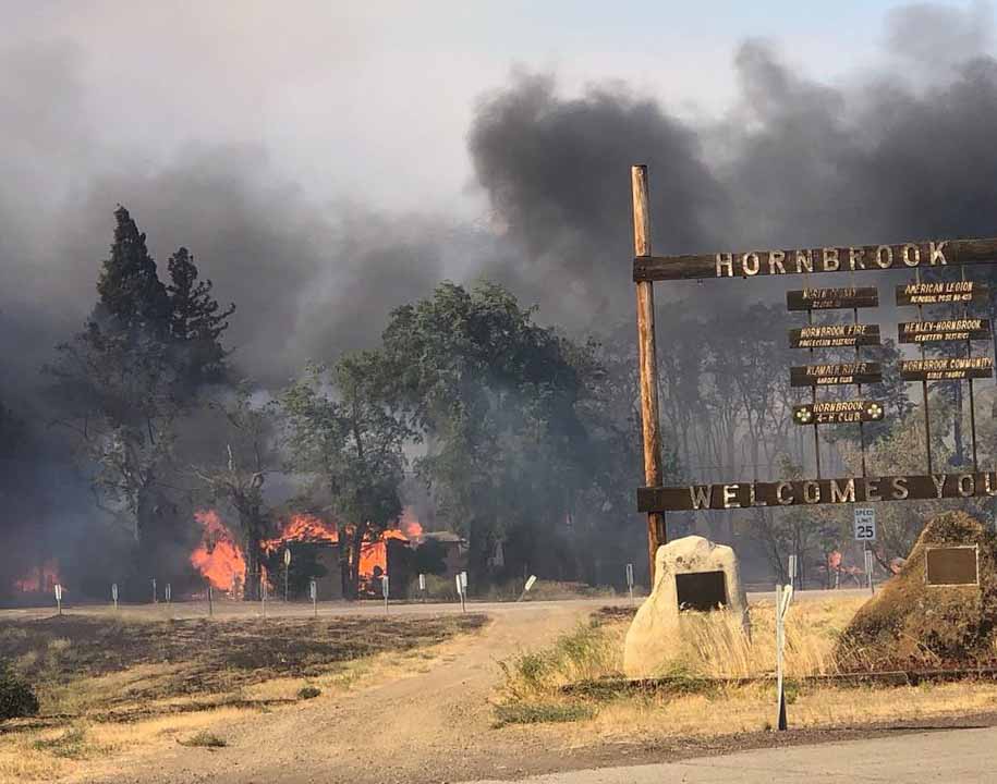
Klamathon Fire burns into Hornbrook, California, closes I-5

(Above: CHP photo)

(UPDATED at 12:37 p.m. PDT July 6, 2018)

From KOBI5:

A civilian has died due to the Klamathon Fire, CAL FIRE reported Friday morning. The identification of the person will be released after further investigation and notification of next-of-kin. No further information was released.


(UPDATED at 7 a.m. PDT July 6, 2018)

CAL FIRE reported at 6 a.m. MDT Friday that the Klamathon Fire along Interstate 5 just south of the Oregon border is now 8,000 acres with “multiple structures threatened and damaged or destroyed”. Evacuation orders are in effect.

The California Highway Patrol is now escorting traffic on Interstate 5 through the burned area.


(Originally published at 3:35 a.m. PDT July 6, 2018)

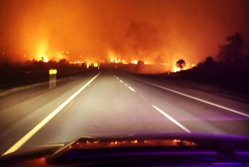
The Klamathon Fire that started Thursday afternoon under windy conditions in northern California spread very quickly into the small community of Hornbrook. Burning on both sides of Interstate 5 it kept going north at least another seven miles to another small town, Hilt, which is about a mile south of the Oregon border.

CAL FIRE said approximately 5,000 acres and multiple structures have burned.

Interstate 5, the major thoroughfare connecting California and Oregon, was closed Thursday night between Yreka, CA and Ashland, OR.

Klamathon Fire
Klamathon Fire, Friday night. CHP photo.
Klamathon Fire
Klamathon Fire, Friday night. CHP photo.

While the fire was growing quickly Thursday afternoon a 20 to 26 mph south wind was pushing it along the Interstate. By midnight the wind slowed to just a few miles per hour and that trend is predicted to continue Friday, but the relative humidity will still be low, around 15 percent. This should slow the spread somewhat, but now firefighters have thousands of acres of fire to contend with.

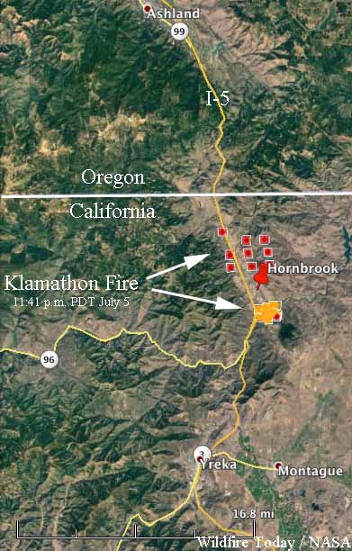
map Klamathon fire
Map showing the approximate location of the Klamathon Fire at 11:41 p.m. PDT July 5, 2018. The red dots are the most current. We hope to replace this with a better map when it becomes available.

There are no details yet about the extent of damage in the communities, but the early indications are that it could be severe.

Firefighters hope to prevent the County Fire from crossing Hwy. 128

The fire has blackened approximately 82,700 acres

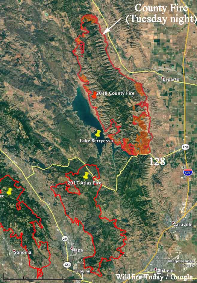
Above: The map shows the southern end of the County Fire where firefighters are working to keep it from crossing the narrow sections of Lake Berryessa and Highway 128. The red shaded areas represent intense heat observed during a Tuesday night mapping flight.

(Originally published at 8:19 a.m. PDT July 4, 2018)

During the first two days the County Fire 26 miles west of Sacramento burned about 1,000 acres an hour, but that spread has slowed recently as firefighters have has success, but difficult terrain in some areas has presented a challenge. The fire has blackened approximately 82,700 acres.

One of their main priorities is to keep the fire from moving south across Highway 128. The map above shows they have made progress toward that goal. If it spreads across the highway it would threaten many homes in the Allendale and Vacaville area. If it grows around the southern tip of Lake Berryessa it could burn into the footprint of last October’s Atlas Fire, northeast of Napa, where the resistance to suppression would decrease dramatically.

county fire map
Map showing the perimeter of the County Fire, Tuesday night.

County Fire expands to 70,000 acres

Approaches Solano County

Above: The currently burning County Fire is shown along with other large fires from last year.

(Originally published at 12:55 p.m. PDT July 3, 2018)

The County Fire in Napa and Yolo Counties continued to grow Monday and Monday night, chewing up more vegetation on the west and southeast sides.

It has moved to within two miles of the Solano County line. If it proceeds beyond that and across Highway 128 it would threaten many homes in the Allendale and Vacaville area. If it grows around the southern tip of Lake Berryessa it could burn into the footprint of last October’s Atlas Fire, northeast of Napa, where the resistance to suppression would decrease dramatically.

CAL FIRE announced Tuesday that the County Fire had burned about 70,000 acres.

The fire is being battled by 2,162 personnel, including 187 engines, 56 hand crews, 18 helicopters, 50 dozers, and 51 water tenders.

County Fire roars through the hills above Lake Berryessa

The fire is burning northeast of the San Francisco Bay area 19 miles northeast of Napa and 28 miles west of Sacramento.

(Originally published at 6:12 a.m. PDT July 2, 2018)

Burning in both Yolo and Napa Counties, the County Fire has doubled in size in the last 24 hours. The blaze is running across Rocky Ridge east of Lake Berryessa northeast of the San Francisco Bay area.

(Click Here to see all of the articles on Wildfire Today about the County Fire, including the most recent.)

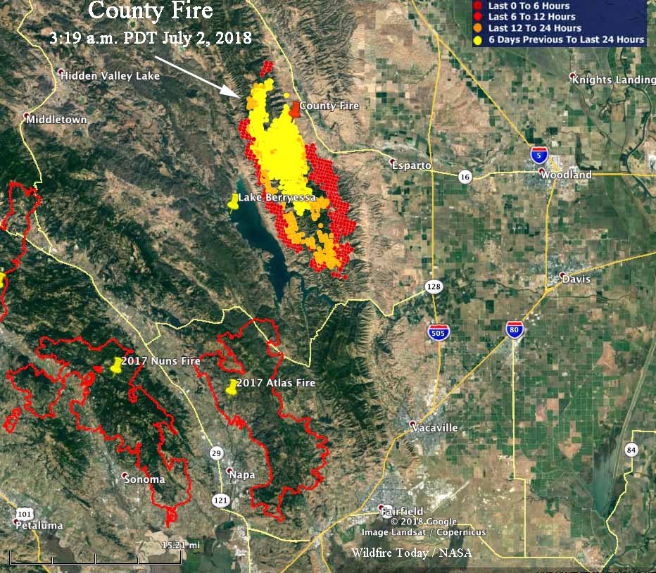
Our VERY UNOFFICIAL estimate based on satellite data indicates that at 3 a.m. Monday it had burned approximately 42,000 acres — roughly 1,100 acres an hour since it was reported at 2:12 p.m. June 30. CAL FIRE’s official estimate released at 7:49 p.m. Sunday put it at 32,500 acres. During the 3 a.m. overflight there were large areas of very active fire, as represented by the red dots in the map below.

County Fire map Atlas fire
Map showing heat detected on the County Fire by a satellite at 3:03 a.m. PDT July 2, 2018. The footprints of fires that devastated large areas in October 2017 are also shown: the Atlas, Nuns, and Tubbs Fires. Click to enlarge.

The County Fire is spreading northeast of the areas devastated by the North Bay Area Fires of October, 2017 that destroyed over 7,000 structures and killed 31 people. The footprint of the Atlas Fire could serve as a partial barrier, reducing the chance that this new fire could reach the Napa area again. But if it keeps moving south and crosses Highway 128 into Solano County there are many homes that could be threatened in the Vacaville area.

Many areas are under mandatory evacuation orders. For questions regarding Yolo County evacuations or advisories, dial 2-1-1. For questions regarding Solano County evacuations or advisories dial (707) 398-8261.

Evacuation center: Guinda Grange Hall in the Community of Guinda 16487 Forest Ave. Guinda, CA 95637.

The fire is being battled by 1,226 personnel, including 119 fire engines, 27 hand crews, 12 helicopters, 23 dozers, and 34 water tenders.