We lost another firefighter

Pine Valley Creek Bridge
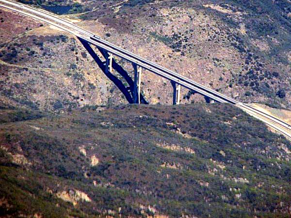
Bridge on Interstate 8 over Pine Creek near Pine Valley, California as seen from an airliner July 11, 2005. Uploaded to Wikipedia by NicksGarage.

On Sunday November 5 we lost another wildland firefighter to the suicide epidemic. After completing his shift that morning at CAL FIRE’s Station 20 in El Cajon, California Captain Ryan Mitchell took his own life at the Interstate 8 Pine Valley bridge in San Diego County near Pine Valley.

“This tragic and unexplainable incident has affected many personnel in the Unit, both those that knew Ryan and those that responded to the incident”, Unit and County Fire Chief Tony Mecham wrote Sunday in a message to the county firefighters. “I am proud of our personnel and the efforts undertaken today under very difficult conditions. I especially want to thank those personnel who spent the day at the scene and accompanied Ryan to the Medical Examiners Office this evening.”

“While we may never know exactly what lead to this tragic event”, Chief Mecham continued,  “what we do know is that mental health issues are real and no one should feel embarrassed or ashamed to ask for help. Circumstances at work and in our personal lives affect our mental health and quality of life. There are many resources available to all of us through Employee Support Services, Employee Assistance Programs and our own personal network.”

On November 4 we wrote about the shocking  number of wildland firefighters who have taken their own lives. According to Nelda St. Clair of the Bureau of Land Management we lost 52 in a two-year period, 2015 to 2016.

Chief Mecham is right. Help is available.

The image below that we posted on Facebook is an abbreviated version of help sources that could be posted on bulletin boards or stuffed into employee mailboxes.

suicide sources for help

Canyon 2 Fire caused by ember from previous fire

The Canyon 2 Fire destroyed approximately 15 homes and damaged 45 others in Anaheim, California

Canyon Fire map
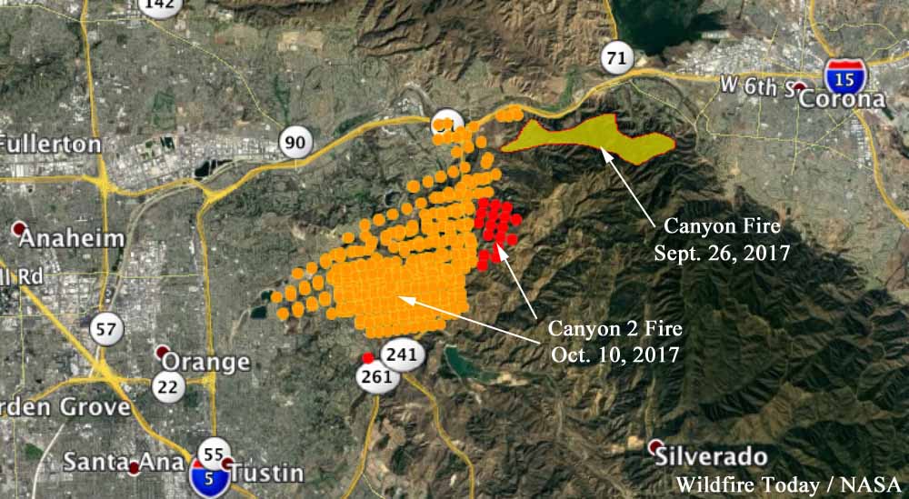
The red dots represent heat detected on the Canyon 2 Fire by a satellite at 2:54 a.m. October 10. The yellow dots were detected at 12:54 p.m. October 9. The Canyon Fire started September 25, and the spread was stopped a few days later. Click to enlarge.

The Canyon 2 Fire that burned 9,200 acres and destroyed or damaged 60 homes started from an ember that blew from the previous Canyon Fire that blackened 4,300 acres south of the 91 Freeway between Anaheim and Corona, California.

The cause of the Canyon 2 Fire was released Monday by Anaheim Fire & Rescue Chief Randy Bruegman. According to the LA Times, Chief Bruegmann said the ember originated about 20 feet inside the fireline of the first fire, the Canyon Fire, and was blown about 50 feet into brush outside the line.

The Canyon fire damaged four homes and started July 25 when a Caltrans road flare was knocked off the 91 Freeway into grass by a passing vehicle. The Canyon 2 Fire began October 9.

Interim Chief of the Orange County Fire Authority (OCFA), Patrick McIntosh revealed October 25 that the first full dispatch of fire suppression equipment to the Canyon 2 Fire occurred 71 minutes after the first report of “smoke and flames”. By the time the first units arrived, the new fire was well established. The Chief said he would recommend to the County Board of Supervisors an independent review be conducted of how the fire was handled.

The OCFA has the responsibility under a contract for suppressing vegetation fires within Anaheim city limits. Monday the LA Times reported Anaheim Chief Bruegman said that arrangement is currently under review.

Our Opinion

Of course hindsight is always 20/20, and investigations could confirm this or not — but a person could argue that if the OCFA had done two things differently, there may have been a vastly different outcome for the Canyon 2 Fire.

  1. Thorough mopup of the first fire, the Canyon Fire. Most wildfires are completely extinguished hundreds of feet inside the fireline or perimeter. The ember that the wind blew from the fire 15 days after it started, was only 20 feet from the perimeter.
  2. A reasonably quick and aggressive attack of the new fire, the Canyon 2 Fire, rather than a 71 minute delay.

RIP Stan Stewart

Stan Stewart
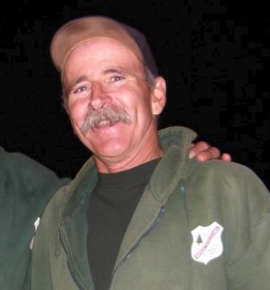
Stan Stewart. Photo from YouCaring.

A long-time wildland firefighter well known by many passed away Saturday night, November 4, with his wife, Allison, and son, Shane by his side. Stan Stewart lost his nine-year battle with cancer after spending his last days in a hospice in Santa Barbara, California.

As the Superintendent of the Los Padres Hotshots he became a mentor and father figure for decades of firefighters. Stan dedicated his life to training personnel and striving to improve the safety of boots on the ground. Many have have crossed paths with Stan at some point in his thirty-five year tenure with the L.P. Hotshots.

A fundraiser has been posted on YouCaring to help pay for Stan’s hospice care and other costs that were not covered by his health insurance. The site explains that his wife and 14-year old son have accumulated an overwhelming amount of medical bills.

Our sincere condolences go out to Allison, Shane, other members of his family, his friends, and co-workers.

Sonoma County officials criticized for inadequate warning about approaching wildfires

A system that can send emergency notifications to every cell phone in a designated area was not used.

Soon after the Pocket, Tubbs, and Nuns Fires burned thousands of homes in northern California in the days following the October 8 wind event, local residents began asking why they received no emergency notifications on their cell phones.

The day before, all cell phones in Rincon Valley east of Santa Rosa loudly blared with a message about a child abduction in San Francisco about 48 air miles to the south, but the Amber Alert system was not used as the wildfires bore down on the densely packed communities in Sonoma County.

Photo by Jeff Zimmerman
Tubbs Fire. Photo by Jeff Zimmerman.

Officials did use two other systems, Nixle and SoCo Alert, to send messages to less than 35,000 cell phone users. Those programs require people to opt-in or sign up in advance.

But most residents in Sonoma County did not receive any notifications by phone as the fires approached between 10 p.m. and 6 a.m. They found out as neighbors knocked on their doors or police drove around blasting sirens.

At least 23 people in Sonoma County died in the fires.

Below are excerpts from an article in the Press Democrat:

“I’m emotional when it comes to this, and I’m a rational guy,” said Patrick McCallum, who fled the fires with his wife, Judy Sakaki, president of Sonoma State University.

They burned their bare feet and ran for their lives as flames tore through their Fountaingrove neighborhood. By that point, about 4 a.m., the Tubbs fire, which started outside Calistoga 9 miles to the east, had been burning more than six hours. McCallum, however, was only awakened by a smoke alarm and the couple’s home already was on fire. The landline phone in the bedroom never rang.

The [Amber Alert] program is available to the Sonoma County Emergency Services division, housed within the county fire department. Emergency officials have said publicly they opted against using the program because they didn’t want alerts to go out countywide and cause mass evacuations that could have prevented first responders from reaching affected areas.

“In this rushed environment to inform as many people as possible, we were worried that notification would go out too broadly, and potentially clog roads,” Sonoma County spokeswoman Hannah Euser said.

But state emergency officials have said the system can send messages to smaller geographic areas.

Inadequate notification of residents also occurred in November of last year as the Chimney Tops 2 Fire burned into Gatlinburg, Tennessee. Fourteen people died as a result of the wildfires and nearly 2,500 structures were damaged or destroyed by flames that charred more than 17,000 acres in and around Great Smoky Mountain National Park.

Simulation shows winds near origins of Oct. 8 fires in Northern California may have been 75-90 mph

“Hurricane force” winds, according to the National Weather Service, are sustained winds or frequent gusts of 74 mph.

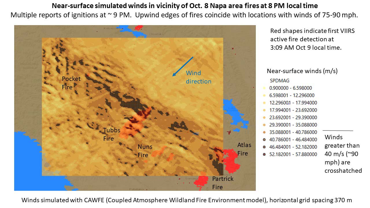
Above: Fine-scale weather model simulation (horizontal grid spacing of 370 meters) analyzing the surface wind when the Northern California fires started, 8 p.m. local time October 8, 2017. The darkest brown areas (with cross-hatching) indicate wind speeds greater than 40 m/s (~90 mph). The red shapes indicate heat from active fires first detected by a satellite (VIIRS) at 3:09 a.m. local time October 9, 2017.  Simulation by Dr. Janice Coen, a Project Scientist at the National Center for Atmospheric Research in Boulder, Colorado. Simulated with the Coupled Atmosphere Wildland Fire Environment model.

(Originally published at 10:40 a.m. MDT October 30, 2017.)

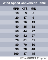
More research into the weather conditions when the devastating October 8 wildfires started in Northern California indicates that hurricane force wind was one of the factors responsiblewind speed conversion table for the extremely rapid spread of the fires that killed at least 43 people and destroyed more than 8,900 structures.

Dr. Janice Coen, a Project Scientist at the National Center for Atmospheric Research in Boulder, Colorado ran fine-scale weather model simulations (horizontal grid spacing of 370 meters) analyzing the wind during the time the fires started. Her research (see chart above) showed significantly higher surface wind speeds than previously thought — 75 to 90 mph just upwind of the major fires.

CAL FIRE has not released the causes of the October 8 conflagrations, but at about the same time firefighters were first responding to numerous fires, they also received multiple calls about fallen power lines and electrical transformers exploding.

California law dictates that power lines are supposed to be able to withstand 56 mph.

In an email Dr. Coen told us more about the October 8 wind simulation and her research related to fire weather:


“These early simulations suggest that within a wide area of strong winds, these small, local bands of extreme winds occurred where winds were perpendicular to the local ridge. And, that the location of the peaks and their peak speeds evolved throughout the event as the wind direction changed, in part due to the high pressure over the Great Basin moving along.

“I don’t have a lot of confidence that we’d be able to find evidence to prove or disprove if/when a particular simulated wind speed maximum occurred.  And, although there is a lot of theoretical and laboratory work on stably stratified flow over objects, this three-dimensional terrain is too complicated to apply much of that.

“We’ve seen a sequence of devastatingly destructive fire events each driven by strong wind events – 2007 fires in southern California driven by Santa Anas, surprising destruction from a mountain downslope wind-driven fire in Gatlinburg, TN, and now this – yet fine-scale investigations of the mechanisms producing the peak winds and how they are distributed, particularly in relation to potential ignition sources, don’t really exist. And, though our forecast models may indicate strong gusty winds are possible, explicitly predicting how extreme the winds might be and where the most dangerous spots are with the detail shown here is beyond their capabilities.

“I hope to learn and share more about the mechanics of these events by visualizing these simulations, so we can see inside these events, prepare and anticipate, contribute to firefighter awareness and safety (as Diablo winds in general are a regional fire issue), and perhaps help potential ignition sources such as utilities manage the risk.”

wind simulation october 8 fires northern california
Fine-scale weather model simulation (horizontal grid spacing of 370 meters) analyzing the weather during the time the Northern California fires started, 8 p.m. local time October 8, 2017. The darkest brown areas indicate wind speeds greater than 40 m/s (~90 mph). Simulation by Dr. Janice Coen, a Project Scientist at the National Center for Atmospheric Research in Boulder, Colorado.

Report: California power company has resisted efforts to map risky power lines

portugal power lines wildfire
File photo of power lines near a wildfire in Portugal, 2012.

Following the Witch Creek, Guejito, and Rice Canyon fires that destroyed more than 1,300 homes and killed two people in Southern California in 2007, state officials began attempting to force the utility companies to produce maps designating areas where their power lines present the highest risk for starting wildfires. The three large fires in 2007 were sparked by issues with lines operated by San Diego Gas and Electric.

CAL FIRE has not released the causes of the huge fires that started in Northern California October 8 during very strong winds, but at about the same time firefighters were first responding to numerous fires, they also received multiple calls about fallen power lines and electrical transformers exploding. In the next week, the stock price of the company that provides electrical service for large areas of Northern California, Pacific Gas and Electric, dropped 22 percent.

According to the Mercury News, PG&E has been fighting the efforts to map powerline risk areas since 2007. Below is an excerpt from their article:

A review of the mapping project by the Bay Area News Group shows that utilities have repeatedly asked to slow down the effort and argued as recently as July that, as PG&E put it, certain proposed regulations would “add unnecessary costs to construction and maintenance projects in rural areas.”

On Oct. 6, two days before the start of the deadliest outbreak of wildfires in California history, two administrative law judges assigned to oversee the project granted yet another delay at the request of PG&E and other utilities.

[…]

[PG&E] claimed there was no evidence that wildfires had been caused by poles not being able to withstand high winds.

The Northern California fires killed at least 43 people and destroyed about 8,900 structures.

Dr. Janice Coen, a Project Scientist at the National Center for Atmospheric Research in Boulder, Colorado ran fine-scale simulations (horizontal grid spacing of 370 meters) analyzing the wind during the time the fires started. Her research showed significantly higher surface wind speeds than previously thought — 75 to 90 mph just upwind of the major fires.

California law dictates that power lines are supposed to be able to withstand 56 mph.