Above: Morning briefing for firefighters on the Wildomar Fire, October 27, 2017. USFS photo.
(Originally published at 12:24 p.m. PDT October 27, 2017)
According to the U.S. Forest Service Friday morning the Wildomar Fire south of Lake Elsinore in California has grown to approximately 700 acres. It was reported at 12:32 p.m. Thursday in the Wildomar Off Highway Vehicle area in the Cleveland National Forest west of the community of Wildomar.
The weather is warm and dry in the higher elevations where it is burning at 2,600′. At 9:20 a.m. Friday the El Cariso weather station 5 miles to the northwest recorded 80 degrees, 15 percent relative humidity, and a 7 mph NNE wind. But east of the fire the terrain drops 1,400′ to the Elsinore Valley where at 8:49 Friday morning it was 57 degrees, 60 percent relative humidity, and no wind.
Two DC-10 Very Large Air Tankers were working the #WildomarFire at 10:39 am PDT Friday, along with a lead plane, air attack, and at least one helicopter.
Friday’s forecast for the higher elevation is for 88 degrees, 11 percent relative humidity, and northwest to north winds of 9 mph. Saturday should be about the same.
The photo above of the Friday morning briefing showed an active smoke column not long after sunrise.
3-D map showing the approximate location of the Wildomar Fire based on satellite data from 12:31 a.m. PDT October 27, 2017. The white line was the approximate perimeter at 2:11 p.m. PDT October 26, 2017.
The time-lapse video below shows the fire from about 14 miles to the southeast. It was shot by a camera at the Santa Margarita Ecological Reserve, from its ignition time at around 1 p.m. Thursday, overnight, and into the morning of Friday October 27, 2017.
The Wildomar Fire that started early Thursday afternoon is threatening structures south of Lake Elsinore, California. The Cleveland National Forest reported that it had burned about 200 acres by 3:30 p.m. PDT. It is burning toward the northeast primarily in brush and at 4:10 p.m. it had approached the South Main Divide Road which runs toward the south from the Ortega Highway near the top of the slope west of Wildomar.
Evacuations have been ordered for the Hixon Truck Trail area.
Map showing the approximate location of the Wildomar Fire at 2:11 p.m. PDT October 26, 2017.
On the live video feed from KTLA we watched one of the DC-10 Very Large Air Tankers drop retardant near the base of the slope just above residences several hundred feet away from the fire. Other air tankers and CAL FIRE helicopters are also assisting firefighters.
A DC-10 Very Large Air Tanker drops between the Wildomar Fire and the community of Wildomar.
A helicopter drops water in support of a hand crew that was attacking a spot fire at 4:24 p.m. October 26, 2017. Screen grab from KTLA live video.
The weather station at El Cariso a few miles north of the fire recorded temperatures Wednesday afternoon around 90, humidity about 10 percent, and winds out of the southwest at 12 mph — conditions conducive to significant fire spread.
We will update this article as more information becomes available.
Fire Chief calls for independent investigation of early decisions made on the fire that destroyed or damaged 60 homes in southern California.
Interim Fire Chief Patrick McIntosh at October 25 news conference about the Orange County Fire Authority’s response to the Canyon 2 Fire.
In a news conference Wednesday the interim Chief of the Orange County Fire Authority (OCFA) revealed the timeline for actions taken, and not taken, when the Canyon 2 Fire was first reported on October 9, 2017. The fire eventually burned 9,200 acres, destroyed 15 homes and damaged 45 others. For the last week the OCFA has been criticized over reports the initial response to the fire was delayed.
Chief Patrick McIntosh said Wednesday “flames and smoke” were first reported in a 911 call at 8:32 a.m. near the 91 freeway and the 241 Toll Road interchange in Orange County, California. The nearest fire station, Station 53, was not staffed because about three hours earlier the wildland engine was dispatched with four others from the OCFA to one of the fires in Northern California. Support personnel at the station were asked if they could see smoke. They went outside and seven minutes later reported they could only see what appeared to be ash blowing off the previous Canyon Fire.
At 9:27 and 9:28 two more reports came in of smoke near the 91 Freeway and Gypsum Canyon which is in the same area as the earlier report. At 9:31 one engine from Station 32 and a helicopter were dispatched.
At 9:41 personnel at Station 53 said they could see a column of smoke which appeared to be building and recommended additional resources.
Chief McIntosh said the OCFA initiated a “High Watershed Dispatch” at 9:43 which included 7 engines, 2 helicopters, 2 water tenders, 2 dozers, 1 hand crew, 2 air tankers, and one fixed wing air attack.
The Orange County Register earlier this week reported on some details about the response of aerial resources:
At 9:52 a.m., the first OCFA helicopter lifted off from Fullerton Airport. But a second helicopter – which a Fire Authority memo dated Oct. 8 said was required because of “red flag warnings” in effect that week – did not leave and had to be dispatched again five minutes later.
The fixed-wing planes that would have been part of a “medium level” response were not en route until 10:19 a.m., from Hemet, 51 minutes after the fire was reported.
There are also questions about the helicopters operated by the Orange County Sheriff’s Department that were not used on the fire. The ships reportedly have water dropping capabilities but may or may not be certified by state or federal agencies to work on wildfires. The OCFA and the Sheriff’s office have been feuding about the responsibilities of their two helicopter fleets. Historically the Sheriff’s fleet has taken the lead for searches, while the OCFA has handled rescues. In the last year, however, the Sheriff has been poaching responses to rescues resulting in multiple helicopters appearing over the same incident potentially causing airspace conflicts and confusion.
In the news conference the Chief said he will recommend to the County Board of Supervisors an independent review be conducted of how the fire was handled.
“My heart tells me we could have done something different”, the Chief said, but he wants to wait for the review before saying exactly what that should have been.
“Our commitment to you and to our community is full disclosure, full transparency, we have nothing to hide as an agency” the Chief continued. “If there are things that need to be done better and different, we will do those.”
In Fullerton at 8:53 a.m. the day the fire started, about 9 miles northwest of the fire, the winds were calm and the relative humidity was 68 percent. But by 12:53 p.m. the humidity had dropped to 5 percent and a Santa Ana wind was blowing from the east at 24 mph gusting to 35 mph — conditions that could cause a wildfire to spread rapidly.
Sometimes a timid initial attack can lead to the loss of structures. The U.S. Forest Service and other agencies spent a small amount of money on the anemic and delayed initial attack of the 2012 Waldo Canyon Fire. But later, homeowners and insurance companies had to spend $353 million for the property that was destroyed in Colorado Springs. Other times a weak response can result in a large fire that kills many people, such as the 1994 South Canyon and the 2013 Yarnell Hill Fires which killed a total of 31 firefighters. The Waldo Canyon Fire also killed two residents. And let us not forget the Chimney Tops 2 Fire. Very little ground-based action occurred during the first five days which then spread into the eastern Tennessee city of Gatlinburg killing 14 people, forcing 14,000 to evacuate, destroying or damaging 2,400 structures, and blackening 17,000 acres.
Thanks and a tip of the hat go out to Mike. Typos or errors, report them HERE.
Above: A screen grab from drone footage uploaded October 11 of fire damage in Santa Rosa, California. Since then most of the numbers of lives and homes lost have about doubled. Los Angeles Times.
(Originally published at 1:48 p.m. MDT October 22, 2017)
Even many people who were not physically affected by the recent disastrous wildfires in Northern California are still stunned by what happened beginning the night of October 8 when very strong winds, hurricane force in some locations, pushed incredibly powerful fires through neighborhood after neighborhood.
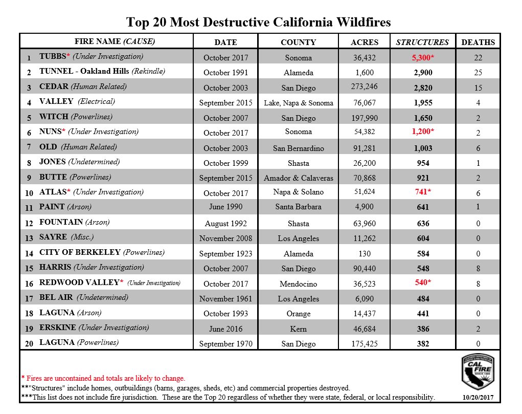
The latest preliminary data reveals that four of the fires have found places in the list of 20 most destructive fires in California history when measured by the number of structures destroyed. Those four fires, Tubbs, Nuns, Atlas, and Redwood Valley accounted for the destruction of over 7,700 homes, commercial buildings, sheds, garages, and barns. Two of the three largest wildfires have occurred in the last four years.
Those who lost their possessions and homes are going to be hard pressed to find places to live for the next year or two. The state already has a severe housing shortage.
But what comes next in the big picture? People wring their hands and send thoughts and prayers. Is that enough? Most accidents and disasters provide a teaching moment. Will this one be squandered like so many times before after floods, hurricanes, mass shootings, and wildfires? Mentally disabled people accumulate assault rifles and homes are replaced in flood, fire, and hurricane-prone zones. Rinse and repeat.
…The state requires that new buildings in zones deemed by the state to be at high risk of fire be made with fire-resistant materials, such as tile roofs. The state and local governments should also consider requiring older homes and buildings in high-risk zones to be retrofitted.
Unfortunately, urban areas often weren’t included by the state in its designated high-risk zones because, well, nobody expected a wildfire to sweep through a city. State officials are now revising the maps, and the fires around Santa Rosa must surely be a wake-up call that suburbia has to be made more fire resistant.
Four of the recent wildfires in Northern California are tentatively in the list of the top 20 fires in California, as ranked by structures destroyed. The exact numbers will probably change in the coming weeks as the post-fire surveys conclude.
“Structures” includes ALL structures — homes, commercial buildings, sheds, garages, and barns.
Above: Some of the firefighters that have been working on the Tubbs and Nuns Fires for the last week. Photo by Twitter user @WineMeAway.
(Originally published at 10:47 a.m. PDT October 18, 2017)
On Tuesday there was minimal activity on two of the four large fires in Napa and Sonoma Counties north of San Francisco, the Atlas and Tubbs Fires.
There has been major progress on the Nuns and Pocket Fires but there is still open line on those two blazes where firefighters are conducting fairly large burn out operations to remove fuel between the lines and the active edge of the fires.
Map of the Pocket Fire. The red line was the perimeter at 10 p.m. October 17, 2017. The white line was the perimeter about 24 hours before. The red dots on the north side represent heat detected by a satellite at 3:42 a.m. PDT October 18, 2017 and are in an area where firefighters were conducting a firing operation to secure control lines.
Mandatory evacuations and road closures are still in effect in many areas.
The total size of the Nuns, Pocket, and Tubbs Fires in Sonoma and Napa Counties has risen to 103,285 acres. At least 5,017 structures have been destroyed. There have been 41 fatalities on the Northern California fires since the siege began October 8.
Map of the north end of the Nuns Fire. The red line was the perimeter at 10 p.m. October 17, 2017. The white line was the perimeter about 24 hours before. The red dots east of Highway 12 and north of Kenwood represent heat detected by a satellite at 3:42 a.m. PDT October 18, 2017 and are in an area where firefighters were conducting a firing operation to secure control lines.
The resources assigned include 579 engines, 60 water tenders, 32 helicopters, 10 air tankers, 101 hand crews, and 95 dozers, for a total of 5,274 personnel.
Map showing the location of wildfires north of San Francisco, October 18, 2017.