Comparing post-fire recovery at two burn sites

video platformvideo managementvideo solutionsvideo player

KRCR has an interesting article about post-fire recovery at two burn sites in northern California, discussing how different conditions at the time of the wildfires affected the vegetation now present in the areas. One is recovering much better than the other.

Below is an excerpt from the article:

This is how a forest fixes itself.

WEAVERVILLE, Calif. – Forest fires can destroy everything in their paths, burning trees and vegetation until the landscape is uninhabitable for months or sometimes even years. But, they can also usher in new life, creating a completely new ecosystem and fostering new growth.

The Oregon Fire of 2001, just outside of Weaverville, left devastation on the landscape that has yet to grow back 14 years later.

In comparison to the Eagle Fire of 2008, in a similar region of Trinity County, this wildfire burned large patches of landscape, but the forest is already starting to rebuild itself with trees and shrubs 7 years later.

Why is it that the landscape of the Eagle Fire is healing in half the time as the Oregon Fire landscape?

“Nature is a dynamic thing,” said Eric Knapp, research ecologist for the Shasta-Trinity National Forest Service. “Sometimes you see a big patch that has been burned at high severity. It won’t recover for many decades to even centuries.”

Knapp has dedicated his career to studying how ecosystems rebuild themselves after a devastating wildfire.

His colleague, Ben Newburn, is a forest fire chief, also of the Shasta-Trinity National Forest Service. Both have examined the landscapes of the two fires and determined why the Oregon Fire land remains desolate while the Eagle Fire land hosts life.

“It depends on the intensity and severity at which it burned,” explained Newburn. “The majority of the landscape at the Eagle Fire actually burned at low severity.”

Newburn added that was because of a few factors. The Eagle Fire was earlier in the summer than the Oregon Fire. There was more moisture in the soil and vegetation. Therefore, trees were not totally destroyed and life could come back more quickly.

“The fire burned 7 years ago and so the brush we’re seeing growing back now has grown in that time,” said Newburn. “We’re starting to see some saplings.”

In contrast, the Oregon Fire happened later in the season, when there was less moisture. Trees burned all the way through, leaving it hopeless for them to grow back.

When trees and vegetation are burned completely through there’s less of a chance of regrowth. Regrowth happens with one crucial ingredient: seeds…

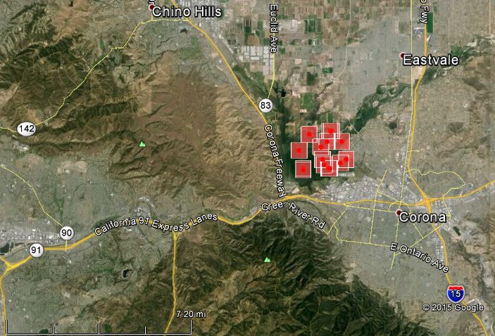
Highway Fire near Corona, California

Map of Highway Fire 1130 pm 4-18-2014
The red squares indicate the location of heat detected by a satellite on the Highway Fire at about 11:30 p.m. April 18, 2015. The locations shown are accurate to within a mile.

(UPDATED at 1:17 p.m. PDT, April 20, 2015)

Riverside County Fire announced this morning that the Highway Fire northwest of Corona, California was holding at 1,020 acres and the Incident Commander is calling it 35% contained. All evacuations and road closures have been lifted.

****

(UPDATED at 7:50 a.m. PDT, April 20, 2015)

Riverside County Fire announced Sunday evening that the fire had burned 1,020 acres. The cause was identified as an unattended cooking fire.

****

(UPDATED at 2:13 PDT, April 19, 2015)

Riverside County Fire issued information at 11:15 this morning saying the fire has been mapped at 980 acres.

****

(Originally published at 8:07 a.m. PDT, April 19, 2015) 

The Highway Fire has burned hundreds of acres in the Prado Basin just northwest of Corona, California. CAL FIRE spokesperson Mike Mohler said the fire is in thick vegetation that has not burned in decades. Approximately 700 personnel are assigned. The fire was first reported at 6:12 p.m. on Saturday.

There are no reports of injuries to firefightes or damage to structures.

All mandatory evacuations have been lifted, including residents of 300 homes on Bluff Road, Homestead Road and Stagecoach Road.

The last official size of the fire provided by Riverside County Fire was 300 acres at midnight Sunday morning, but it may be significantly larger.

Highway Fire
Highway Fire, April 18, 2015. Photo by Crystal Rios.

California firefighter dies during training

Inmate Firefighter Raymond Araujo suffered a heart attack while engaged in a training exercise on the Morongo Indian Reservation near Banning, California on April 13. The 37-year old firefighter succumbed to his injury after being airlifted to a base camp where he was treated by CAL FIRE and Riverside County Fire Department medics.

The incident occurred in Hathaway Canyon on the Morongo Indian Reservation near Banning, California.

Our sincere condolences go out to his family.

Potwisha fire in Sequoia Kings Canyon burns 20 acres

Potwisha Fire
Potwisha Fire. NPS photo.

A fire that started Saturday near Potwisha Grade on California Highway 198 in Sequoia Kings Canyon National Park in California was knocked down after it burned 20 acres.

By the end of the day evacuations were lifted that affected Buckeye and Potwisha Campgrounds, the Potwisha Overflow parking lot, and the Hospital Rock Day Use Areas.

Firefighters on the ground were assisted by two air tankers, T-44 (a P2V) and T-72 (an S2T). The drop by T-44 is one of the first times a federal air tanker has been used this year

Potwisha Fire
Potwisha Fire. NPS photo.

Escaped prescribed fire in California required evacuations

A prescribed fire near Victorville, California escaped on March 31 causing mandatory evacuations in the southern California desert community. Two helicopters assisted firefighters in stopping the 185-acre blaze as it burned through heavy vegetation that had not burned in years.

The project in Mojave Narrows Regional Park was designed to remove cattails, but firefighters said shifting winds caused it to grow out of control Tuesday afternoon.

A car and an outbuilding burned in the fire. The evacuations were lifted after several hours.