The National Weather Service predicts strong winds in areas of Northern California Tuesday and Wednesday, lasting into Thursday in the Bay area.
There are no Red Flag Warnings in effect, but the wildland fire danger for today, February 1, ranges from low in the higher elevations to severe in portions of the Bay and North Bay areas. It will also be very high to severe in some locations between San Francisco and Santa Barbara.
The forecast for Sacramento on Tuesday calls for sunny skies, 58 degrees, 33 percent relative humidity, and afternoon winds of 23 mph winds out of the north-northwest at 23 mph gusting to 32 mph. On Wednesday the wind and temperature will be similar, but the RH will drop to 21 percent. The Thursday forecast has the wind decreasing to 5 mph with 18 percent RH.
Wildland fire danger, Northern California, Feb. 1, 2022.
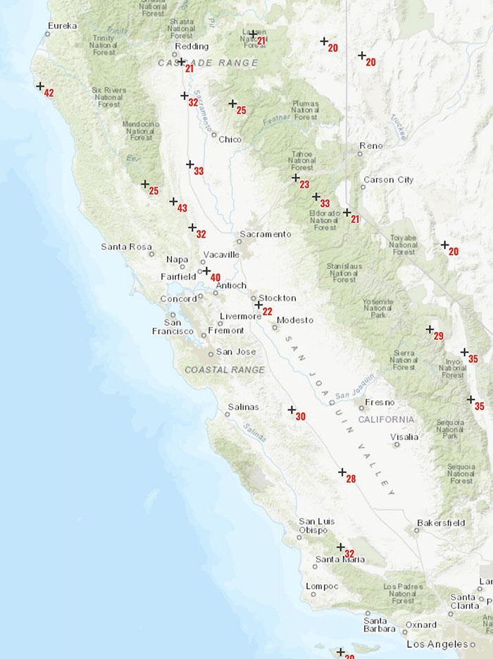
The map below shows wind gusts at 8:12 a.m. PT, Feb. 1, 2022
Wind gusts at 8:12 a.m. PT, Feb. 1, 2022. NWS.
The Hot-Dry-Windy index on Tuesday for the North Bay area is above the 90th percentile, but it does not take into account the condition of the vegetation, i.e., fuel moisture.
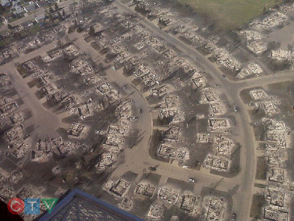
Burned homes in Slave Lake. May 16, 2011. Alberta, Canada. CTV.
Researchers have found that building codes based on lessons learned during the deadly 1991 Tunnel Fire in the Oakland Hills of California can reduce the vulnerability of homes to wildfires.
In a paper titled Mandatory vs. voluntary adaptation to natural disasters: the case of U.S. Wildfires, authors Patrick W. Baylis and Judson Boomhower describe how they scoured property and wildfire records to identify which homes were constructed under building codes requiring enhanced resistance to wildfires.
Chapter 7A of the California Building Code which went into effect in 2008 requires certain fire resistance measures, including exterior construction materials used for roof coverings, vents, exterior walls, and decks. It applies to new construction of residential and commercial buildings in designated fire hazard severity zones.
The researchers discovered that a 2008 or newer home is about 16 percentage points (40%) less likely to be destroyed than a 1990 home experiencing an identical wildfire exposure. There is strong evidence, they concluded, that these effects are due to state and local building code changes – first after the deadly 1991 Oakland Firestorm, and again with the strengthening of wildfire codes in 2008. The observed vintage effects are highly nonlinear, appearing immediately for homes built after building code changes. There are no similar effects in areas of California not subject to these codes or in other states that lack wildfire codes.
Their findings are similar to those in a paper published October 4, 2021 in which researchers analyzed the structures that were destroyed and those that survived the Camp Fire that ran through the city of Paradise, California in 2018. They considered at least four primary characteristics of structures:
Were they built before or after the adoption in 2008 of Chapter 7A of the California Building Code.
Distance to nearest destroyed structure.
Number of structures destroyed within 100 meters.
Pre-fire overstory tree canopy within 100 meters
They found that the last three criteria were the strongest predictors of survival. Homes more than 18 meters (59 feet) from a destroyed structure and with less than 53 percent pre-fire overstory canopy within 30 to 100 meters (98 to 328 feet) survived at a substantially higher rate than homes in closer proximity to a destroyed structure or in areas with higher pre-fire overstory canopy. Most fire damage to surviving homes appeared to result from radiant heat from nearby burning structures or flame impingement from the ignition of near-home combustible materials. The researchers concluded that building and vegetation modifications are possible that would substantially improve outcomes. Among those include improvements to windows and siding in closest proximity to neighboring structures, treatment of wildland fuels, and eliminating near-home combustibles, especially within 1.5 meters of the structure.
(The video below was shot December 31, 2021, the day after the Marshall Fire destroyed more than 1,000 homes in Boulder County, Colorado. Notice that most of the surviving homes seen in the video had fewer homes in close proximity.)
The authors noted that while Chapter 7a includes requirements not found in many building codes, a few other codes are more complete incorporating multiple construction classes based on anticipated radiant heat, flame, and ember exposure levels. For example Chapter 7A does not consider the interaction between components such as siding, window, and the under-eave area on an exterior wall.
California is embarking on a pilot project in which owners of vulnerable homes in lower income neighborhoods will be given grants up to $40,000 to retrofit the structures, making them more resistant to wildfires.
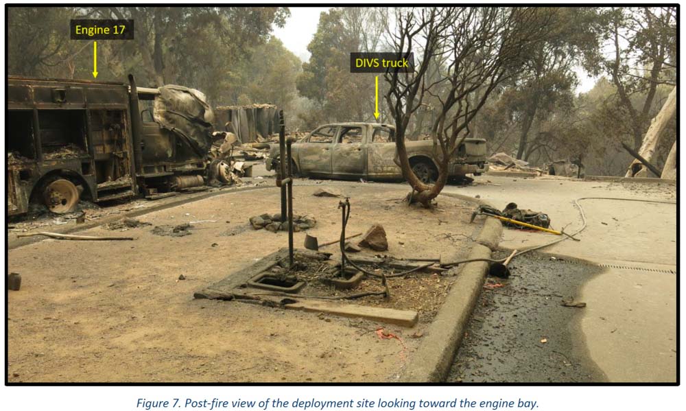
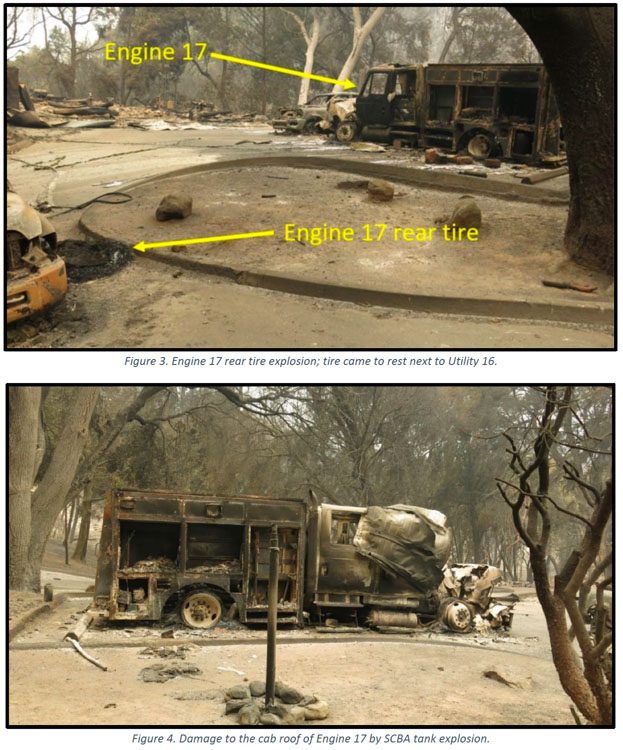
The Nacimiento guard station, two fire engines, several personal vehicles, and two dozers burned — there was one very serious injury
Dolan Fire deployment site. Engine & pickup. Image from the report
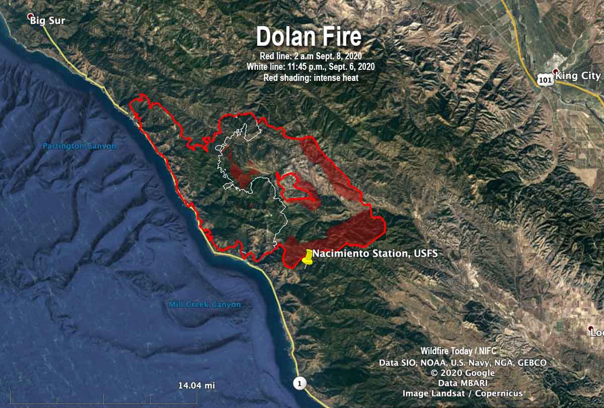
Several “learning reports” have been released by the U.S. Forest Service about the burnover and entrapment one and a half years ago of wildland firefighters at a remote fire station. It occurred on the Dolan Fire on the Los Padres National Forest in Southern California September 8, 2020. Fifteen firefighters deployed into only 13 fire shelters. Four firefighters were injured and three were hospitalized. One had very serious burns.
The Dolan Fire had been burning for weeks but there were about half a dozen other fires in California that were larger, some much larger such as the LNU Lightning Complex, SCU Lightning Complex, CZU August Lightning, and the August Complex.
The Incident Management Team ran a modeling scenario on September 4 which showed that within the next 14 days the probability of the fire reaching the Nacimiento Guard Station was 60 to 80 percent with no delaying tactics. At that time the fire was 3.1 miles away.
The night before the fire reached the station on Nacimiento-Fergusson Road 7 miles from the highway on the California coast, the fire ran for about three miles toward the station, burning 30,000 acres with spot fires three-quarters of a mile ahead. The map below based on infrared data shows the growth in the 26-hour period ending at 2 a.m. on Sept. 8. The fire hit the station between 7 and 8 a.m. on September 8.
Map of the Dolan Fire. The red line was the perimeter at 2 a.m. PDT September 8, 2020. The white line was the perimeter about 26 hours earlier. The red shaded areas indicate extreme heat.
When the fixed-wing aircraft mapped the fire five or six hours before the incident, it had burned about 74,000 acres, more than twice the size mapped the previous night. The sensors on the plane detected intense heat on the southern edge of the fire, 0.7 miles north of Nacimiento Station.
The fire personnel at the station during the burnover included two USFS engine crews, two dozers with operators, and the only Division supervisor working the night shift — due to a shortage of personnel. Other overhead at the fire may have been distracted as a newly established Incident Command Post had to be evacuated and relocated as the fire approached in the middle of the night.
Dolan Fire deployment site. Engine 17. Image from the report.
Several of those involved at Nacimiento believed there was no way to defend the station even though a hand crew had cleared some vegetation, a hand line had been dug, and there were hose lays around the structures. With that work done and the fact that the station had survived other fires, some of the locals said they could protect the buildings and the personal belongings and vehicles of the fire personnel who lived there.
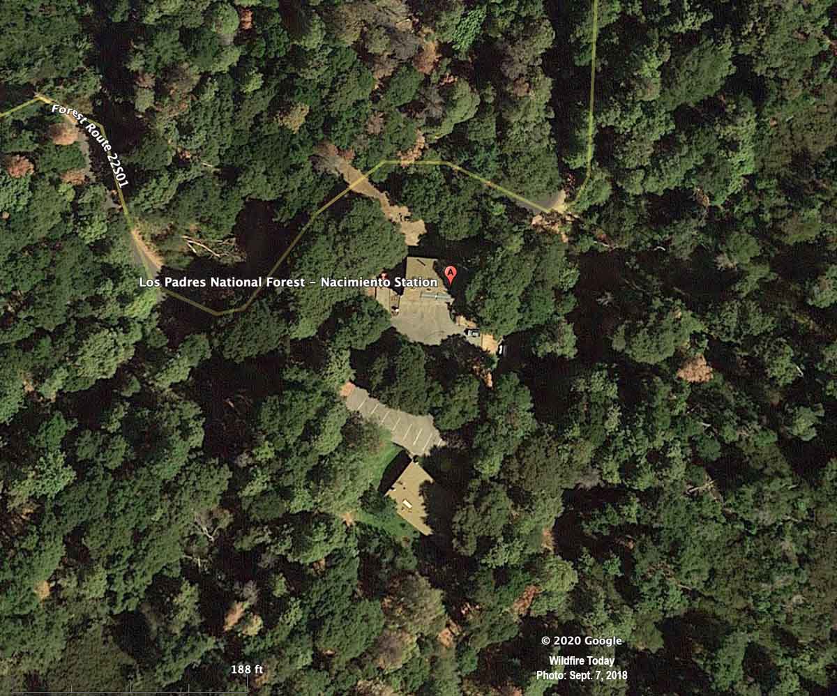
Below is an aerial photo of the Nacimiento Guard Station taken almost exactly two years before the burnover. It appeared in an article on Wildfire Today about the entrapment published September 11, 2020.
Nacimiento Station, satellite photo, September 7, 2018.
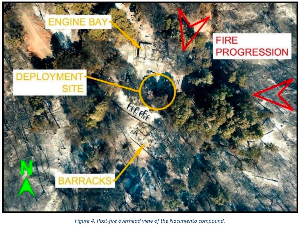
The photo below was taken after the burnover.
Dolan Fire deployment site, aerial photo. Image from the report.
This is the first paragraph in the Learning Review — Narrative:
Smoke is billowing out of the barracks and hot embers are raining down all around. Engine 16 is on fire. The engine bay is on fire. Marty can’t get his pack out of the burning engine, which means he can’t get to his fire shelter. He’s just standing there, and Rene can’t get his attention. She has her shelter out, ready to go. She hits him, but he just stands there. She hits him again, but he still just stands there. Marty is not ready to commit to the shelter; he’s thinking about potential dangers from the propane tanks around them, and that more needs to or could be done. Rene hits him again and pulls down on his shirt to get him down to the ground and into the fire shelter. Rene tucks the fire shelter around him and cinches it in tight under his arms and legs. She takes a quick look around and then climbs in under the shelter with him. Eleven other firefighters are deployed around them in the parking lot of the Nacimiento guard station. The heat inside the shelters was stifling. “I could feel the skin tightening on my face. Mucous was coming out of my nose and eyes, hanging off my chin. I felt like all the fluid was being roasted out of me. My throat was so sore I could barely drink my water.” Everyone is asking the same question: “How did we get here?”
“If we preach it, we should do it.”
The Organizational Learning Report has a section, Theme 3, pointing out that even though the Forest Service has “preached [to homeowners] FireWise concepts for decades” about how to reduce the chances of their houses burning as a wildfire approaches, too many of the agency’s own structures lack FireWise status. The report says, “If we preach it, we should do it. ”
We asked Kelly Martin for her thoughts about the reports on the Dolan Fire. She is the current president of Grassroots Wildland Firefighters and the retired Chief of Fire and Aviation for Yosemite National Park. She replied by text:
The biggest thing that comes to mind is our over confidence in what we deem ‘defendable’ until the time wedge becomes too small to make safe, proactive decisions. The oppressive personal/social pressure to protect treasured places puts us in an untenable situation to champion the notion, ‘not on my watch’ are we going to lose this place. The protection narrative gets repeated and reinforced by the majority who consider it ‘their home turf’ and unfortunately tend to dismiss many ‘outsiders’ objective perspectives on the situation that might help reduce the deep personal attachment to ‘home turf.’ Having ‘Outsiders’ become part of the decision making process can help enhance rational decision making.
Confirmation bias may have been a factor. The fire station survived previous fires, thus lulling us to previous events rather than fully appreciating the situation we now find ourselves in with excessive fuel buildup.
Also, I think the Wildfire Decision Support System (WFDSS) process and further high level local management and Incident Management Team analysis should have spotted this mindset trap early on.
Our Take
The disaster at the Dolan Fire is yet another example where knowing the real-time location of the fire may have made a difference. The Captain who ran the station and some other locals believed that they needed to protect the facility and insisted that they COULD. Others thought differently but were not assertive enough or didn’t have the authority to override that decision. They knew the fire was approaching. But would things have turned out differently with others who didn’t have emotional attachments to the buildings? Or who had real-time intelligence, and could “see” the locations of all resources as well as the entire fire — the very rapid rate of spread, the spot fires ¾ mile ahead, and the intensity? What if the Operations Section Chief, Branch Director, primary Safety Officer, or the Incident Commander had access to real-time video from a drone circling over the fire? Any one of those might have ordered the withdrawal of the engines, dozers, and 15 firefighters hours before they came close to death. They might have said, “Forget the damn structures. Think about the humans. Consider the physical and mental trauma those humans could suffer, perhaps for years.”
The decision to stay or go, in addition to human safety, should have also considered the dollar value of the personal belongings and vehicles of the employees who lived at Nacimiento. They were not evacuated days earlier even though the station was in a mandatory evacuation area. They trusted the Incident Management Team, the Forest overhead, and the Captains. How much will it cost those firefighters, on their meager salaries, to replace their personal vehicles and belongings? Then there is the cost to taxpayers of two engines, two dozers, and at least one pickup truck.
The technology has existed for years to provide real-time video of fires 24 hours a day. The John D. Dingell, Jr. Conservation, Management, and Recreation Act required that by September 12, 2019 the five federal land management agencies “develop consistent protocols and plans for the use on wildland fires of unmanned aircraft system technologies, including for the development of real-time maps of the location of wildland fires.”
While this technology has been demonstrated and used sparingly, such as the FIRIS program, real-time mapping is far from being used routinely.
The Dingell Act also mandated that the five federal land management agencies “jointly develop and operate a tracking system to remotely locate the positions of fire resources for use by wildland firefighters, including, at a minimum, any fire resources assigned to Federal type 1 wildland fire incident management teams,” due by March 12, 2021.
The Bureau of Land Management has installed hardware for Location Based Services (LBS), which are now operational on more than 700 wildland fire engines, crew transports, and support vehicles. Vehicle position and utilization data are visually displayed via a web-based portal or mobile device application. Ten months after it was required by Congress, the U.S. Forest Service has made very little progress on this mandate.
Some other government facilities are also not FireWise
It is not just the Forest Service with structures that do not all meet FireWise standards. When I was an area Fire Management Officer for the National Park Service, two of the parks for which I was responsible were threatened on different occasions by wildfires. Although the threat was low to moderate, I was able to convince the Park Superintendents that hazard reduction and thinning of the trees was necessary, now. It should have already been done, but seeing smoke in the air made it possible to make fast decisions and to get it accomplished very quickly. Up until then, removing any tree near park headquarters was a tough row to hoe. Neither fire spread into the parks, but the long-delayed and badly needed work got done. And I slept better.
At Del Rosa fire station in Southern California the VP was introduced by a wildland firefighter
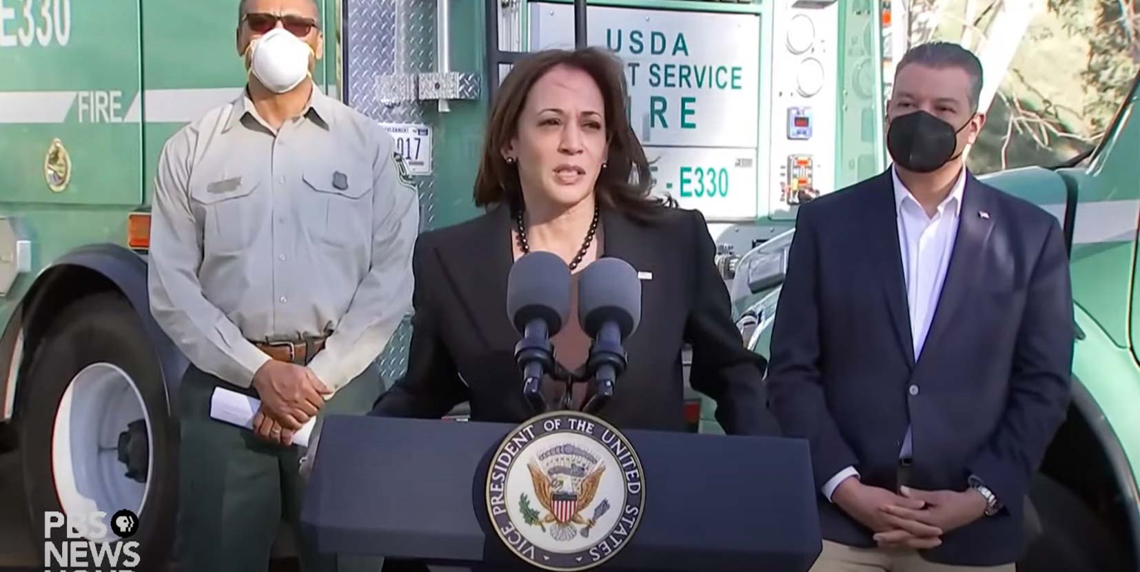
Vice President Kamala Harris at the San Bernardino National Forest, January 21, 2022.
On Friday Vice President Kamala Harris traveled to California where she spoke about wildland fires and the fact that federal firefighters are “underpaid given the nature and value of their work.”
Her 12-minute speech was made at Del Rosa fire station on the San Bernardino National Forest as she stood in front of US Forest Service fire apparatus, Engine 330 and a Del Rosa Interagency Hotshot crew buggy.
“On behalf of the President and myself I want to thank all the men and women who serve in such difficult times but always with such grace. Thank you Sarah and thank you Chief,” the Vice President said as she began her remarks. Sarah Hudson, a firefighter, introduced the VP. More about that below.
Later the Vice President mentioned the pay of federal wildland firefighters.
“There will be $5 billion, and more actually,” she said, “for wildfire preparedness and resilience, and it will include, and this requires its own conversation, a pay raise for our federal firefighters. And I invite everyone to become familiar with the history of this issue and for how long they have been underpaid given the nature and value of their work, and so we are very, very excited to acknowledge their work not only in words but with the pay that recognizes the value of the skill and the dignity of the work that they perform…And I am very proud of the folks who in particular are on the ground doing this work every day. As I have said before I will say again, you inspire us all.”
The Vice President spoke for 12 minutes about wildland fire and reducing their impact, and never mentioned raking the forest.
She also covered the resilience of communities threatened by fire.
“We are talking with home owners and reaching out to communities,” she said, “to figure out how we can support them to create a community that is less likely to be so significantly damaged if a fire should hit.”
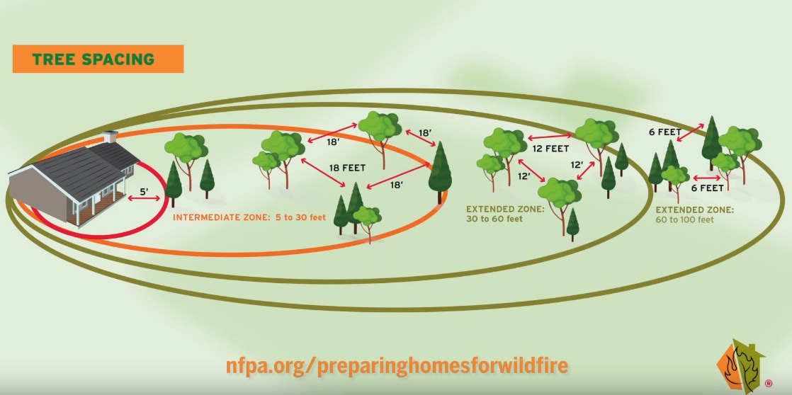
The Home Ignition Zone should be an extremely high priority in preventing structures from burning as a wildfire approaches.
“Surprisingly, research has shown that home ignitions during extreme wildfires result from conditions local to a home,” wrote retired US Forest Service Research scientist Jack Cohen in a 2020 article on Wildfire Today. “A home’s ignition vulnerabilities in relation to nearby burning materials within 100 feet principally determine home ignitions. This area of a home and its immediate surroundings is called the home ignition zone (HIZ). Typically, lofted burning embers initiate ignitions within the HIZ – to homes directly and nearby flammables leading to homes.”
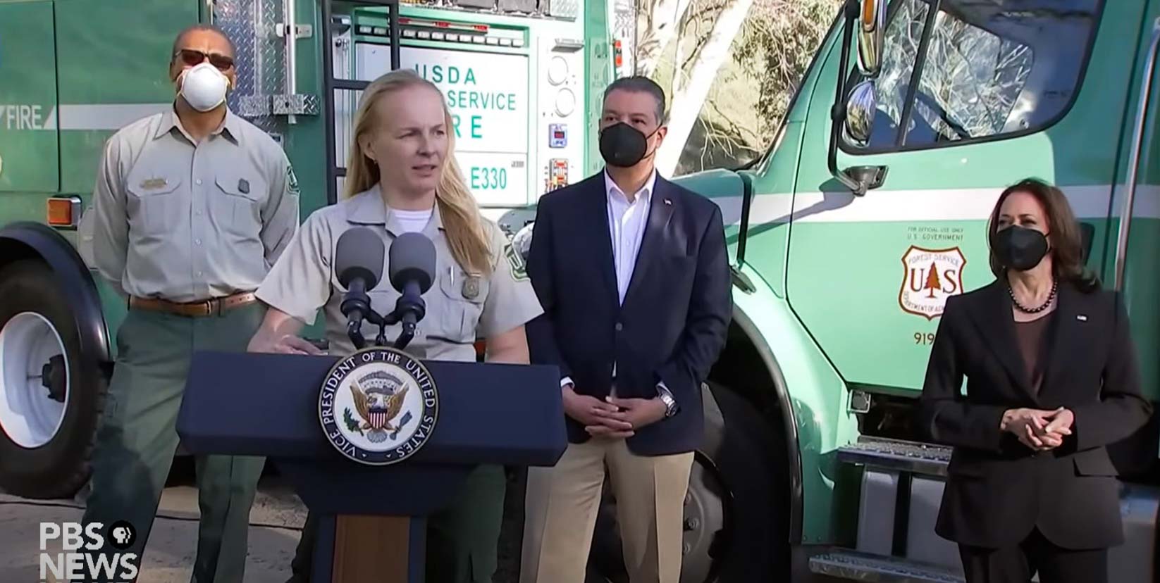
Other speakers at the event included Secretary of Agriculture Tom Vilsack, California Governor Gavin Newsom, and Chief of the Forest Service Randy Moore.
Sarah Hudson, a US Forest Service firefighter with Heaps Peak Helitack, introduces Vice President Kamala Harris, January 21, 2022.
In addition to the dignitaries peaking at the event, Sarah Hudson, a senior firefighter on the Heaps Peak helitack crew on the San Bernardino National Forest made remarks and then introduced the Vice President. This may be the first time a wildland firefighter has performed such a feat. In her spare time Ms. Hudson serves in the California National Guard as a senior airman with the 163rd Attack Wing where she performs maintenance on ground support equipment for remotely piloted aircraft such as the MQ-9 Reaper. On several occasions a National Guard Reaper or similar National Guard drone have assisted firefighters by gathering real time imagery over ongoing wildfires in California.
The entire 35-minute event is covered in the video below.
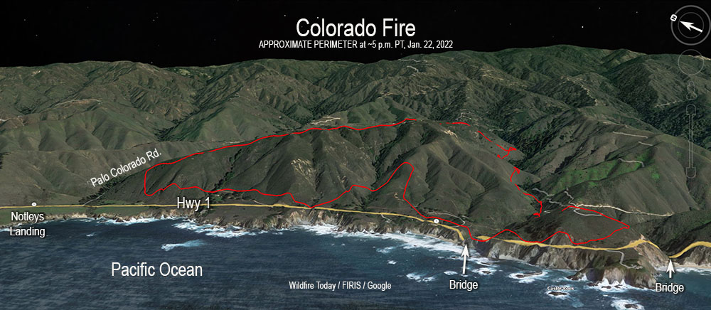
The fire named “Colorado” has burned about 700 acres near Highway 1 near the California coast
Updated at 7:11 p.m. PT Jan. 22, 2022
Smoke drifts away from the Colorado Fire as the sun sets. Photographed by the Keig/Yankee Point camera looking south at 5:24 p.m. Jan. 22, 2022.
The Colorado Fire north of Big Sur, California was mapped at 683 acres by the Fire Integrated Real-Time Intelligence System (FIRIS) aircraft at about 5 p.m. Saturday. This is less than half of the earlier 1,500-acre estimate by the California Department of Forestry and Fire Protection. Fires look larger at night and the terrain at the fire scene is very rugged and difficult to map from the ground.
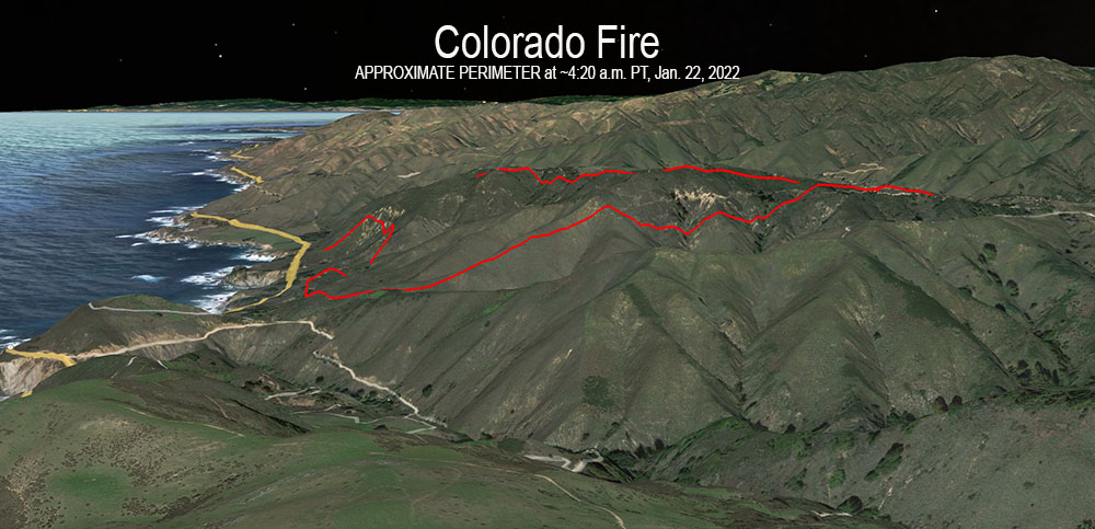
Colorado Fire, 3-D map, approximate location, looking east at 5:24 p.m. PT Jan. 22, 2022.Colorado Fire vicinity map 5:24 p.m. Jan. 22, 2022. Showing part of the footprint of the 2016 Soberanes Fire.
A satellite overflight at 1:22 p.m. local time showed that the fire had spread on the south side near Rocky Creek and on the northwest side southeast of Notleys Landing south of Palo Colorado Road. There has been no indication that the fire has crossed Highway 1, reached the coast, or made any large runs on Saturday afternoon. The fire cameras in the area did not pick up any large smoke columns.
1:04 p.m. PT, Jan. 22, 2022
Colorado Fire, 3-D map showing the APPROXIMATE perimeter at about 4:20 a.m. PT Jan. 22, 2022. Looking north.
A wind-driven wildfire that broke out Friday afternoon north of Big Sur, California has prompted evacuations. The fire just east of the Pacific Coast Highway has forced residents to leave their homes and officials to close a portion of the iconic highway.
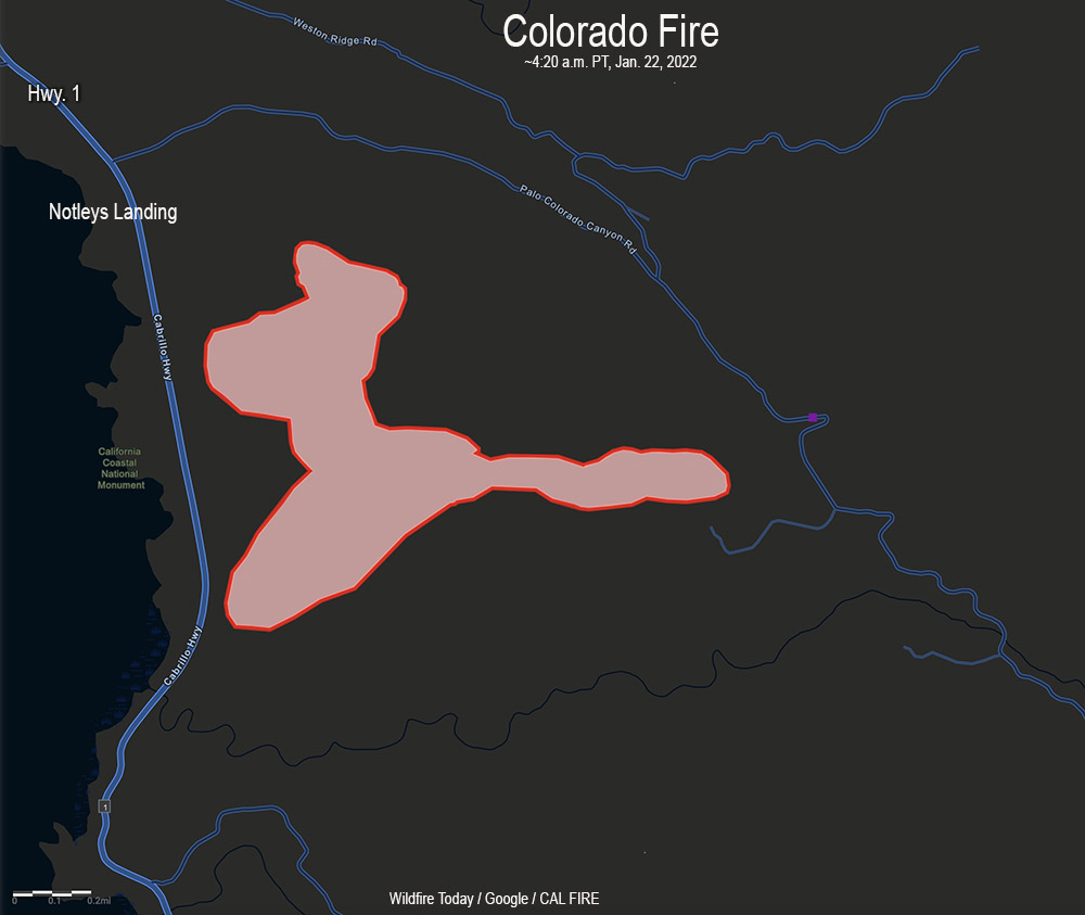
The blaze started near Palo Colorado Canyon Road which led firefighters who usually name a fire after a local landmark, to call it the “Colorado Fire.” (A name which will likely result in confusion.)
Colorado Fire vicinity map ~420 a.m. PT Jan. 22, 2022.
Monterey County has created a map showing evacuations in effect.
The incident is nine air miles north-northwest of Big Sur and seven air miles south of Carmel Highlands.
At 8:19 a.m. on Saturday the California Department of Forestry and Fire Protection said it had burned about 1,500 acres, but that figure is subject to change. At 12:30 p.m. PT there were several CAL FIRE S-2T air tankers flying near the fire.
The Colorado Fire was pushed Friday evening by very strong winds out of the northeast, measured at 41 mph gusting to 52 mph at 5 p.m. at the Old Coast Tower weather station east of Point Sur. The relative humidity was 21 percent. This caused the fire to spread west and southwest, cresting the ridge east of the Pacific Ocean; then the wind shifted. After 9 p.m. it decreased to 10 mph from the south and southeast. Around dawn on Saturday it shifted again, from the north and northwest at 5 to 8 mph. Overnight the humidity rose to 60 percent but dropped to about 30 percent at 11 a.m.
Colorado Fire map at about 4:20 a.m. PT Jan. 22, 2022.Colorado Fire, Jan. 22, 2022. CAL FIRE photo by David Hudson.
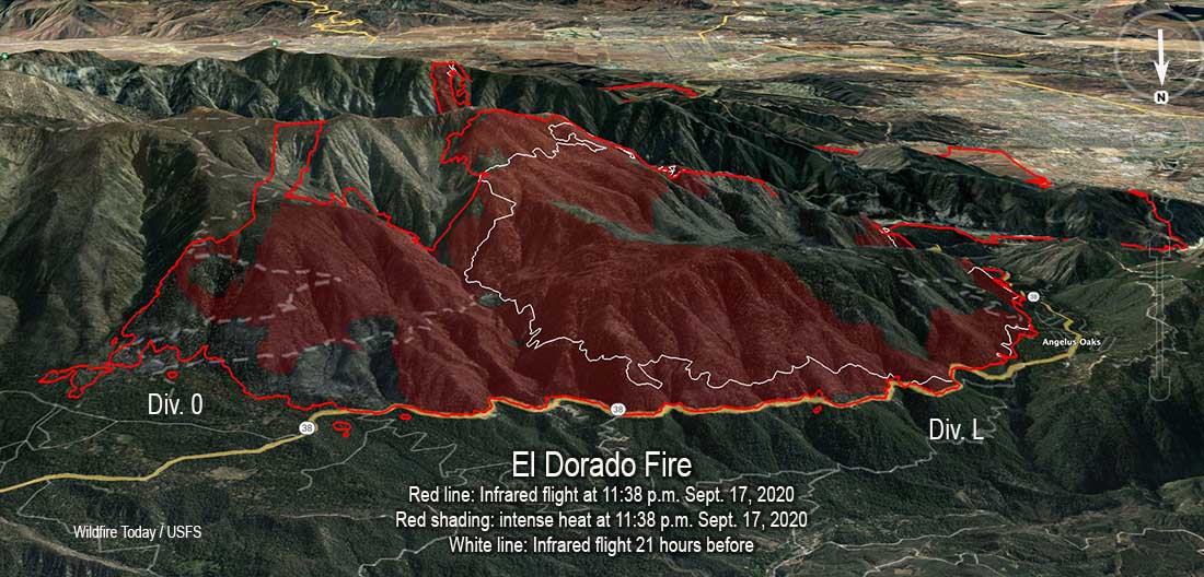
3-D map of the north side of the El Dorado Fire, from infrared flight, 11:38 p.m. Sept. 17, 2020. Looking south.
About 15 months afterCharles ‘Charlie’ Morton was fatally burned on the El Dorado Fire on the San Bernardino National Forest in Southern California, the US Forest Service released a series of reports about the incident.
According to one of the documents, titled Narrative, Charlie, a squad leader on the Big Bear Interagency Hotshot Crew was scouting the fire alone around 7 p.m. September 17, 2020 when it overran his location. Crews had just stopped igniting a burnout. As the fire intensity increased, one of the crew captains asked him on the radio if he was going to be able to get out of the area. Charlie’s response was, “We’ll see.” Following that, the Captain called him several times with no response. He then heard Charlie call in desperation, “I’m in a corner.” It was the last time he transmitted on the radio.
Due to extreme fire behavior, including counter-rotating vortex pairs that formed at his exact location as a result of the burnout operation underway, it was hours before anyone could access Charlie’s location. During that time he was assumed to be missing and the Operations Section Chief assigned the Contingency Branch Director as the Incident-Within-an-Incident Commander to lead the search.
El Dorado Fire Progression map for September 5 to 17, 2020. The report covers activity in Divisions L and O.
For nearly two hours a sheriff’s helicopter utilized their loudspeaker to call out “If you are a lost hotshot firefighter, give us a signal. If you are a lost hotshot firefighter, give us a signal.” At that time firefighters were very busy attempting to suppress numerous spot fires. Some of them were not aware of the missing firefighter when they heard the announcement from the helicopter.
From the Learning Review Narrative, about the beginning of the search:
BR 5 [Branch Director 5] tried to gain access to the bulldozer line from the Camp Round Meadow area and was accompanied by Division L Medic. Although the medic had limited wildland fire experience, it was apparent that the situation was dangerous. He noted falling snags, extreme temperatures, and that fire flanking below them could cut off their egress back to Camp Round Meadow. He thought he was going to die in there and sent a pin of his location to the Division O Medic so that someone could locate Division L Medic if something bad happened.
Meanwhile, SBC Type 2 Initial Attack Crew tied in with Branch and was allowed to fly a small [CAL FIRE] drone equipped with an infrared camera down the bulldozer line to assist with the search. Drone footage showed significant heat along the line which rendered the infrared camera useless. They switched camera modes and flew a few more missions searching various areas.
The conditions were so dangerous that the Safety Officer decided to call off the ground search.
The time of day or night was not mentioned very often in the report, but some time later:
Big Bear captain 1B (who was filling the role of DIVS L trainee) arrived and announced that he was going to search at the bottom of the bulldozer line. BC#1 [Battalion Chief] didn’t want him to go into the area alone, so he decided to join. Big Bear Captain 1B searched the right side of the bulldozer line and BC#1 searched the left. Even with their big flashlights, it was difficult to see through the darkness, smoke, and flames. A quick reflection of light from an accordioned and undeployed fire shelter caught BC#1’s eye on the edge of the bulldozer line near a bend. They stopped 25 feet away and were able to determine that Charlie had not survived.
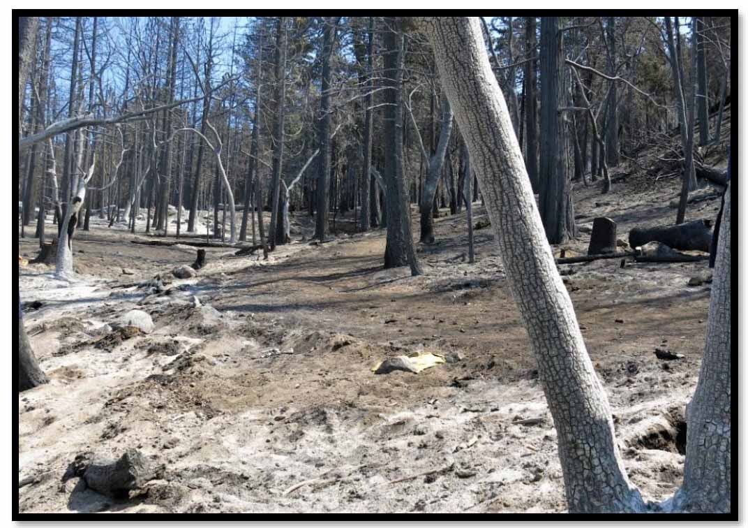
The yellow shirt marks the September 17, 2020 fatality site at the El Dorado Fire. From the report.
The area was still very hot and smoky, and the captain and BC#1 returned to the road below. A medic suggested that she could go to the scene to pronounce Charlie’s time of death, but the decision was made that it was too dangerous. The Safety Officer inserted guards at the bottom of the bulldozer line to keep people from going to view the scene and to prevent another fatality.
At the bottom of the bulldozer line, BR V blew past the guards and went up to the site to be with Charlie and stayed there with him. Some people said to just let him go, but after a period time people began to assume that BR V was fatally lost as well. A second search was organized for BR V. Searchers were unable to access the site due to the heat and falling trees. For approximately a two-hour period, nobody was able to reach BR V because his radio and his cell phone were left in the pickup. Division O Medic returned to stage at DP 45, now waiting to render aid if needed. About 0145, BR V returned down the hill and notifications were passed that he was safe. BR V came down the hill as soon as he realized he’d left his communication devices in his truck.
Charlie is survived by his fiancée, a daughter, parents, and two brothers.
The fire began at 10:23 a.m. September 5, 2020 in the El Dorado Ranch Park in Yucaipa. It was caused by the use of a smoke generating pyrotechnic device. The intent was to produce pink or blue smoke to inform bystanders about the gender of a fetus. A couple was charged with involuntary manslaughter and 29 other crimes.
Other reports
The information above came from the Narrative, a 29-page document that unlike recent facilitated learning analysis (FLA) documents, only covers the very, very detailed chronological facts of what happened on September 17 on the north side of the El Dorado Fire. It does not address, like the FLA for the Cameron Peak Fire for example, 250 Lessons Learned broken down into 14 types of resources (e.g. Finance Unit, Contractors) and 7 categories (e.g. COVID mitigations and testing/contact tracing).
But two other documents were also released about the fatality:
The latter, the Organization Learning Report, breaks with recent established practices, as the Narrative did.
It does not drill down into minutia of what occurred on the El Dorado Fire. It looks at it from 30,000 feet and extrapolates the significance on a much broader scale about the current state of wildland fire management.
It was led by Bill Avey who was appointed to the position of acting director for Fire and Aviation Management in Washington for five months in 2021. He retired December 31, 2021 as the Forest Supervisor of the Helena-Lewis and Clark National Forest in Montana.
Below are excerpts from the seven-page Organization Learning Report. It appears that much of the information came from interviews — not all of the topics are covered in the Narrative. For example, it suggests that perhaps firefighters (or forestry technicians) should be called “fire responders” so they don’t “view fire as an enemy.” Other than that many of their conclusions are very reasonable, even though most of them have been previously identified in various forms. But having so many of them listed in one fatality report is unique, and could be useful. Unless it just disappears into files like so many others.
In his September 24, 2020 testimony before Congress, John Phipps, the Forest Service’s Deputy Chief of State and Private Forestry, stated “the system is not designed for this,” to illustrate the misalignment between the design of the wildland fire system and the reality that wildland fire responders routinely experience.
…
The El Dorado Fire burned as an area ignition resulting from high accumulations of long-burning fuel materials present in the unhealthy forest conditions at the time of the fire. This type of fire behavior was once rarely seen among our wildland fire responders but is becoming increasingly more common because of the current condition of our forests and the influences of climate change. Our current paradigm of treating fire as an enemy that must be defeated contributed to the condition of the forest at the time of the fire. Until we figure out a way to form a new, sustainable relationship with fire, we can expect forest conditions to continue to deteriorate. This deterioration will continue to make situations like this fatality event more probable into the future. We need to see fire’s role on the landscape differently.
…
Viewing fire as the enemy also may have had an influence on local resources “trying to protect their home turf” against that enemy. We are trapped in the paradigm laid out by the philosopher William James’s “Fire is the moral equivalent of War” essays of the early 20th century. Calling our fire employees “firefighters” only contributes to the metaphor of declaring war on an enemy. Perhaps a shift in language (to say…fire responders) may prove beneficial.
…
We continue to ask our wildland fire responders to save communities that are becoming increasingly unsavable. At what point do we declare communities without any semblance of defensible space not worth the risk of trying to save under extreme fire behavior conditions?
…
Two common refrains were heard: “Why am I risking my life and losing time with my family for such futility?” and “The things we did ten years ago are no longer working.” Wildland fire responders feel increasingly isolated and misunderstood, with the expectations from the agency and society to “save the unsavable” while “managing risk.” This coupled with the pay, work-life balance, and hiring issues is eroding the trust and the implicit social contract among wildland fire responders, the Forest Service, and American society. This is another other factor that is quickly resulting in a lack of qualified (or any) applicants and the growing vacancies in fire response crews. On the El Dorado fire, due to a lack of resources, there were four Interagency Hotshot Crews on an incident that would normally have ten.
…
The wildland fire culture has developed in such a way as to defer to the expertise of IHC crews above most other resources on a fire. If the hotshots like the plan, then it must be a good plan…or so the thinking goes. While this heuristic has treated the fire service well in the past; it becomes more problematic if deference is given mistakenly to a resource without the level of expertise that is assumed. Over the course of the last several years, the experience levels of hotshot crews have become diluted. Long-tenured Interagency Hotshot Crew Superintendents seem to be becoming a thing of the past. The Big Bear Interagency Hotshot Crew (IHC), due to a lack of available experienced personnel and coupled by issues with the temporary hiring process, were staffed by a significant number of Administratively Determined (AD) hires, formerly unheard of for an Interagency Hotshot Crew.
…
As federal Interagency Hotshot Crews continue to train and then lose the next generation of leaders, the question must be asked: “At what point will our hotshot crews’ experience levels thin out too much to fill the role we have traditionally asked of them?” And once that occurs, how should we fill that void?
…
The same concerns exist for Incident Management Teams (IMT). With the reduction of 39 percent of the Forest Service’s non-fire workforce since 2000, the “militia” available to assist in IMT duties is rapidly being reduced to a mythical entity, often spoken of but rarely seen. The 2020 fire year was simply the latest in a long string of years where we did not have enough IMTs, let alone general resources, to address suppressing fire in our current paradigm. On the El Dorado Fire, Region 5 took a creative approach to ensure Type 1 oversight by grafting a Type 1 incident commander onto a Type 2 team, when no Type 1 teams were available. While this met the need and policy requirements, one cannot help but wonder what the difference really is between a Type 1 and Type 2 team. Why not just create one national team typing system, and why not ensure that it is staffed to a holistic fire management response (see Theme 2) and not just a direct perimeter control response.
…
Scouting fire lines has proven to be a dangerous task. What barriers prevent federal crews from being able to deploy drones to do the preliminary scouting, rather than having a person do it? How do we overcome those barriers? Note: CAL FIRE crews owned and operated drones on the very same piece of line during the search and rescue operation undertaken to find Charlie.
…
We have the technology to comply with the Dingell Act, shouldn’t the Forest Service mandate, just like we do eight-inch-high leather boots or Nomex, that wildland fire personnel have on a personal tracking device while on the fire line?
…
What is the protocol to determine that a wildland fire responder is missing? What is the protocol to find a missing wildland fire responder? Should there be a national standard to follow to reduce confusion?
…
What is the protocol to obtain notification information for our employees? What is the protocol for notifying fallen employees’ next of kin? Should there be a national standard to follow to minimize confusion and disorganization?
…
CAL FIRE and many other organizations have standard and required emergency notification forms that are available electronically to select individuals.