Tag: California
Firefighters travel from Saipan to fight the Happy Camp Fire
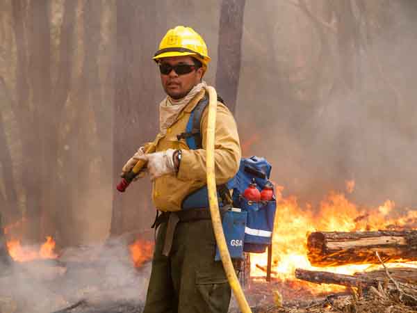
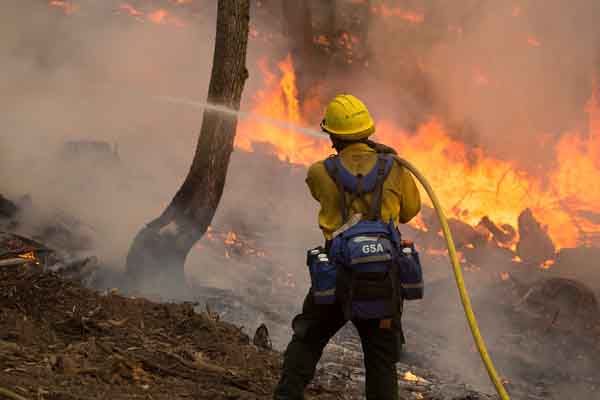
While Rae Brooks was assigned to the Happy Camp Complex of fires in northwest California she wrote this story about a crew from Saipan that was working on the fire. The photos were taken by Kari Greer.
****
Saipan firefighters usually battle scrubby mango and banana tree fires that last a day or two and burn less than five acres. For a month this summer, 15 firefighters from the tiny Pacific island broke in new boots while working on major wildfires in northern California.
The cold, dry night air, the 16-hour work days and the new boots took their toll, but the Saipan crew still raved about their month-long assignment.
“We all have busted-up feet, we’re sick, but we loved it anyway,” said crew member Derek Gersonde. “It’s a great learning experience.”
The Saipan crew flew to California in mid-August as part of a U.S. Forest Service program that brings wildland firefighters to the U.S. mainland to help out when fires are active and resources stretched. In a matter of days, the crew switched abruptly from their sea-level home of sandy beaches and coral reefs to the rugged mountains of northern California.
After being issued wildland fire-fighting gear — and buying wildland boots, which aren’t stocked in Saipan stores — they started building line at the French Fire on the Sierra National Forest.
Crew boss trainee Alle Recor found the crew tended at first to operate on “island time” and lacked the sense of readiness of the wildland world. On Saipan, fires are close by and easy to reach. But, with a little coaching, that soon changed, said Recor. She found the crew motivated, and eager to have fun and get the job done.
Thirteen of the 15 crew members, who range in age from 22 to 48, work primarily as structural firefighters and are qualified medics for the Saipan Department of Public Safety’s Division of Fire. Although wildland firefighting was a new world, the crew understood fire behavior from their structural background, Recor said. Two others were part of a 2008 Saipan crew that fought wildland fires in California
The crew’s fitness and ability to learn new skills quickly impressed crew boss Tyler Van Ormer, who normally works as a battalion chief with the National Forests of Mississippi.
“The guys catch on so quickly that sometimes I forget how green they are,” said Van Ormer. “You only have to show them once and it’s like they’re old hands at it.”
When Van Ormer got word of his assignment, he had to search Google to confirm the island was actually part of the United States. Saipan is the largest of the Northern Mariana Islands, a U.S. territory in the western Pacific, three-quarters of the way between Hawaii and the Philippines.
Instructors from the western United States travel to Saipan each April to provide basic wildland fire-fighting training. Selection to the wildland crew is competitive for course graduates. While wildfires do occur on Saipan, which is smaller than Rhode Island, they are usually caught quickly.
“It’s such a small island that a fire usually runs into a structure and slows down,” said Gersonde. “We don’t have these huge vast mountain ranges that just blow up. You come here and see how fast a fire can run.”
After the French Fire, the crew spent two weeks at the Happy Camp Complex on the Klamath National Forest.
To help hone their practical firefighting skills, five of the Saipan crew embedded with the Sierra Hotshots and some of the hotshots worked with the Saipan crew. The hotshots emphasized safety and proper technique. After a break, the crew returned to Happy Camp for a second stint. They flew home Sept. 17.
Crew boss Van Ormer lauded the Saipan crew’s work ethic.
“They’re disciplined, they’re nice, they’re polite,” said Van Ormer. “If they don’t know something, they ask. I’ve never heard a complaint. They’re the easiest guys I’ve ever worked with.”
The organizational structure behind fighting a big fire boggled the Saipan crew. When they returned to the Happy Camp Complex, 75 crews, 14 helicopters, 108 engines, 20 dozers and 50 water-tenders were working on the fire, which now sprawls over more than 200 square miles.
The entire island of Saipan is only 1,400 square miles.
After exposure to large-scale fires, some crew members find themselves contemplating a new career path in wildland firefighting on the U.S. mainland.
“A lot of us have it on our minds,” said Gersonde.
Fire retardant paint saved a structure? Nope.
I received an email that listed some fire-related news articles, and one of the headlines got my attention:
Fire Retardant Paint Saved Calif. Timber Mill Building
The link took me to an article at Firehouse.com that the website lifted from the Associated Press, and sure enough, there was that headline. I had never heard of paint saving a building from a wildfire, so I was quite curious. I quickly scanned the article looking for how a building was saved by paint, and didn’t see it, so I read the whole thing more carefully.
It was referring to the Boles Fire that burned 150 structures in Weed, California. Much of the story covered the impacts to the damaged lumber mill and the 170 workers. Here is what the headline writer saw that resulted in the misleading headline:
With a maintenance shed reduced to twisted sheet-metal and the main manufacturing facility suffering structural damage, but still standing with a new coat of pink fire retardant, the Roseburg Forest Products veneer mill on the outskirts of Weed was out of commission Tuesday while workers began assessing the damage, said Kellye Wise, vice president for human resources of the company based in Dillard, Oregon.
There was no indication in the article of how much damage was done to the facility, including if it was “saved”, or not, by air tankers dropping retardant, or house paint. The mill has their own fire crew responsible for fighting fires within the facility, and air tankers were not mentioned in the article, except indirectly: “pink fire retardant”.
The same AP story published at the Daily Mail, a UK paper in a country having little experience with large wildfires, had a different headline:
Fire damage to mill another blow to timber town
Often the person that writes the headline is not the author of the story, and this is not the first time that a headline has been misleading.
King Fire almost triples in size
The King Fire west of Lake Tahoe in California grew from 18,544 acres to 70,944 acres on Wednesday, almost tripling in size in 24 hours, running for 16 miles through the El Dorado National Forest. It is now between Hell Hole and French Meadows Reservoirs in Placer County, 12 miles from Olympic Valley, 13 miles from the west shore of Lake Tahoe, and 20 miles from Truckee.
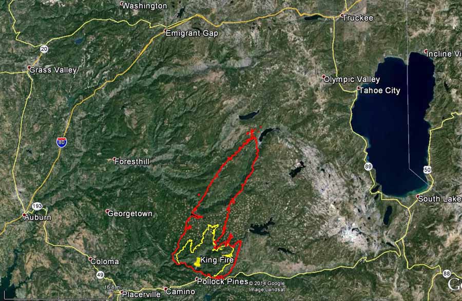
Evacuations have affected 2,155 people.
The fire is being fought by 3,700 personnel. Last year the 257,000-acre Rim Fire at Yosemite National Park had over 5,000 people assigned — this fire may come close to that personnel figure, especially if it continues to add over 50,000 acres a day.
Smoke from the fire is affecting air quality in Boise, Idaho this morning. We have a map showing the distribution of smoke across the western United States as of Thursday morning.
Below is a report from the incident management team describing fire activity Wednesday night:
The fire continued to burn actively throughout the night. However: due to the day’s extreme fire behavior, steep terrain, inaccessibility, variable wind direction, and darkness it was unsafe to approach the north portion of the fire to directly observe the fire behavior. [Through] field observations and Infrared imagery it was determined that the fire made a run of over ten miles to the north between the hours of 1600 and 0600. Spot fires were observed up to three miles ahead of the main fire front.
Our primary and continuing coverage of the King Fire is HERE. If you would like to comment or ask questions, please post them on that article.
Over 100 structures damaged or destroyed in Boles Fire at Weed, California
(UPDATE at 11:10 a.m. PDT, September 17, 2014)
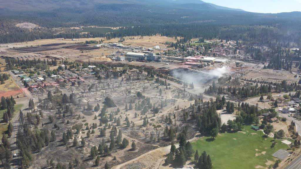
CAL FIRE has revised upward the number of structures that were damaged or destroyed in the Boles Fire that devastated much of the small town of Weed in northern California, now saying 150 structures have been affected. They are calling the 375-acre fire 25 percent contained.
Wednesday morning the Angel Valley and Hoy Road areas were still under evacuation orders. Firefighting resources assigned include 969 personnel, 72 engines, 20 hand crews, and 5 helicopters.
A reward of “up to $10,000” has been offered for anyone providing information about how the fire started.
****
(UPDATE at 3:35 p.m. PDT, September 16, 2014)
****
(UPDATED at 8:30 a.m. PDT, September 16, 2014)
CAL FIRE is still going with the estimate of “over 100 structures damaged or destroyed” in the Boles Fire in the northern California town of Weed. Three of the homes belonged to firefighters. The 375-acre fire is listed at 20 percent containment and evacuations are still in place affecting 2,000 people in the communities of Weed, Carrick, and Lake Shastina.
When the fire started south of Weed Monday afternoon it was pushed by a strong southeast wind gusting over 40 mph. Later in the day the wind slowed, making it possible for firefighters to stop the forward spread of the fire around sunset.
The fire is being managed by CAL FIRE, so the chances are we will not see a map of the fire any time soon.
A photo of my sister-in-law’s house on Morris St., with what used to be a perfect 36 Chevy in the drive. #BolesFire pic.twitter.com/5zCq72MPtb
— Darren Benson (@cursingeditor) September 16, 2014
#BreakingNews — more on #BolesFire: 100 homes burned; 1,500 ppl evac. Pic courtesy @BostonN: http://t.co/qmQrJnG0HX pic.twitter.com/OwfhkBiIc6 — kcranews (@kcranews) September 16, 2014
More than 100 structures destroyed as #BolesFire quickly burns through Weed, Calif.: http://t.co/58KfTZYAaw pic.twitter.com/jP32qa2ADV
— SFGate (@SFGate) September 16, 2014
****
(UPDATED at 8:25 p.m. PDT, September 15, 2014)
CAL FIRE PIO Daniel Berlant said at about 8 p.m. that the fire had damaged or destroyed over 100 structures, and had burned about 300 acres. (Update at 9 p.m.: 350 acres and 15 percent contained.)
****
(Originally published at 5:31 p.m. PDT, September 15, 2014; updated at 5:56 p.m.)
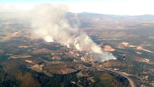
On the internet feed that relays radio traffic from a new fire that broke out at about 1:38 p.m. PDT on Monday, firefighters can be heard estimating that 75 and later 100 structures have been damaged or destroyed in the Boles Fire at Weed in northern California. Pushed by a strong southeast wind at 26 mph gusting at more than 40 mph, the fire has crossed both Interstate 5 and Highway 97, requiring the closure of both highways. There are reports that there is fire in the attic of a school in Weed, as well as structures at a lumber mill. Evacuations are occurring in several areas.
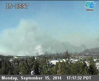
Weed is 58 miles north of Redding, California and 66 miles south of Medford, Oregon. Two DC-10 air tankers have been ordered along with several other aircraft. The DC-10s will probably reload at Medford; Redding also has an air tanker base. With the King Fire near Placerville spreading rapidly, there will likely be competition for firefighting resources.
The area is under a Red Flag Warning until 9 p.m. Monday for strong winds and low relative humidity. The forecast through Tuesday evening predicts winds of 25 mph gusting to 44 mph, gradually decreasing to 14 mph with 23 mph gusts.
In addition to the dozens of engines and water tenders previously ordered, at 5:12 p.m. PDT firefighters placed an order for 20 additional water tenders. With the electricity shut off, obtaining water from traditional sources could be problematic.
At about 5:10 p.m. on Monday, Air Attack said they have a retardant line around about 60 percent of the fire, and most of it is holding, But in other areas firefighters are reporting they are making progress on spot fires, but “we are getting hundreds of them”.
The Incident Commander estimated at about 5:40 p.m. that the fire was 15 percent contained.
Fire shelter deployment on the King Fire
(UPDATED at 3:21 p.m. PDT, September 15, 2014)
CAL FIRE PIO Daniel Berlant sent this tweet at 2:53 p.m. PDT:
This afternoon a CAL FIRE captain & inmate crew deployed their shelters on #KingFire (El Dorado Co.) All are accounted, no reported injuries
Here is another tweet sent by Mr. Berlant:
Latest view of the 3,900 acre #KingFire burning near Pollock Pines in El Dorado Co. Fire remains very active today. pic.twitter.com/ppPNqO88Gd
— CAL FIRE PIO Berlant (@CALFIRE_PIO) September 15, 2014
****
(UPDATED at 2:59 p.m. PDT, September 15, 2014)
All of the firefighters are in helicopters, en route to an airport.
****
(UPDATED at 2:52 p.m. PDT, September 15, 2014)
The 12 firefighters who deployed fire shelters and then ran and walked a long distance to escape from the King Fire 11 miles east of Placerville, California, have reached the landing zone where a helicopter will extract them.
****
(UPDATED at 2:42 p.m. PDT, September 15, 2014)
The drinking water was delivered to the 12 escaping firefighters at the top of the hill at 2:33 p.m. (see the 3-D map below). From there they still have to hike downhill and then on flat ground 1,000 to 2,000 yards to the landing zone. The Helicopter Coordinator (HLCO) overhead is in constant contact with the firefighters, giving them directions as they hike.

****
(UPDATED at 2:23 p.m. PDT, September 15, 2014)
The firefighters are still hiking to a point where a helicopter can land so that they can be extracted. They have to hike uphill and then down the other side. The Helicopter Coordinator (HLCO) coordinating the rescue effort estimates they will reach the landing zone at approximately 2:35 p.m. PDT. The firefighters have run out of drinking water (or previously dumped all of their gear so they could run faster) and are having some heat-related problems, including cramping. A helicopter has been instructed to deliver, presumably by sling load, several cases of drinking water to the firefighters before they reach the extraction point.
At least one helicopter is being rigged with a hoist in case that is needed to extract them from a point where a ship can’t land.
Three ambulances have been ordered to be at the airport where the helicopters will drop off the firefighters.
****
(UPDATED at 1:50 p.m. PDT, September 15, 2014)
The helicopter pilot escorting the 12 firefighters on their escape route told them they were safe at 1:48 p.m. “You guys are looking real good right now”, one of the pilots said. There was talk about getting a large helicopter to drop some water for dust abatement so that another ship could land and pick them up.
****
(Originally posted at 1:27 p.m. PDT, September 15, 2014; updated at 1:32 p.m. PDT, September 15, 2015)
At about 1 p.m. PDT on Monday there was a fire shelter deployment on the King Fire, which is burning 11 miles east of Placerville, California north of the community of Pollock Pines. In listening to the radio traffic, a Division Supervisor talking to Air Attack said a Task Force was overrun by fire, they were in a safety zone, but they were safe. He requested air support, but there was too much smoke for fixed wing air tankers to get in to the area.
Air Attack, as of 1:15 p.m. PDT was checking to see if helicopters could work the area, but when the incident unfolded they were all on the ground getting fuel. Later at about 1:25 p.m. PDT at least one helicopter with water was over the incident watching firefighters running, carrying fire shelters. The pilot was holding on to his water in case there was a major need for it later. He was giving the firefighters directions, saying “keep moving”.
One alternative considered was to extract the firefighters using a water bucket carried by a helicopter.
Someone else on the fire said they had five vehicles that were available to rescue the trapped firefighters, but the road to the area had just been overrun by a very intense fire and they were advised by a pilot to not try it.
There was also a report on the radio of a dozer that burned up, but there was “accountability for the operator”.


