California: Rim Fire at Yosemite NP

(UPDATE at 9:45 a.m. PDT, September 10, 2012)
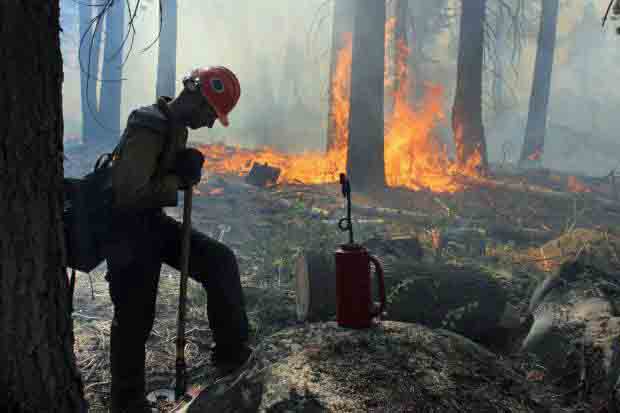
Horseshoe Meadows Hotshots Rim Fire
A crewmember of the Horseshoe Meadows Hotshots, on the Rim Fire, September 2, 2013. USFS Photo by Mike McMillan.

Firefighters have made some progress on the Rim Fire since our last update on September 4. As you can see in the map below, the fire has grown very little in the last six days, and most of the change in the fire perimeter is most likely a result of firefighters burning out the vegetation ahead of the fire.
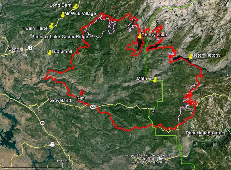
Map of Rim Fire
Map of the Rim Fire. The red line was the perimeter at 1 a.m. PDT, September 10, 2013. The pink line was the perimeter at 9 p.m. PDT, September 3, 2013. The western boundary of Yosemite National Park is shown in green. (click to enlarge)

The fire has burned 254,685 acres and the incident commander is calling it 80 percent contained. Over 3,000 personnel are assigned to the incident, down from more than 5,000 a week or so ago. Over the last 24 days since it started, the costs for suppressing the fire has grown to $100.4 million.

****

(UPDATE at 6:50 a.m. PDT, September 4, 2013)
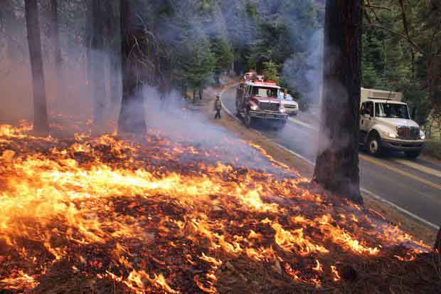
Rim Fire burnout
Rim Fire burnout, September 1, 2013. Photo by Mike McMillan.

As shown in the map below, the spread of the Rim Fire has slowed considerably over the last several days. Most of the acreage increases are a result of burnout operations out ahead of the fire, sometimes miles from the fire’s edge, in order to remove the fuel, eventually stopping the spread. The west and southwest sides of the fire have been very quiet for a few days. The only significant movement of the fire which may not be related to burnouts are on the east side, with most of it being in the Cherry Lake area. On the southeast flank firefighters have selected Highway 120/Tioga Road as their fireline and are burning out along the north side.

The fire has burned 237,341 acres and the incident commander is calling it 80 percent contained. Another 3,000 acres and it becomes the third largest fire in California history.
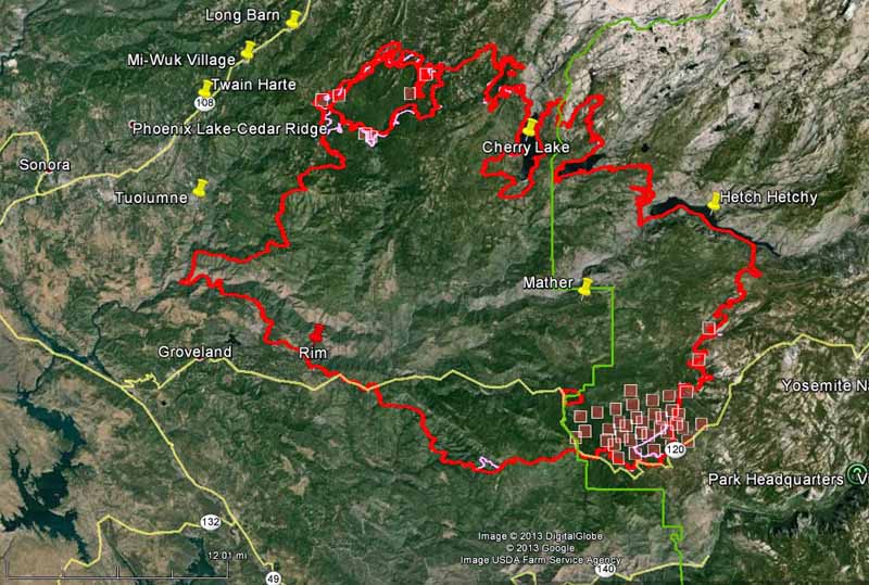
Map of Rim Fire
Map of Rim Fire. The red line was the perimeter at 9 p.m. PDT, September 3, 2013. The pink line was the perimeter about 48 hours before. The red squares represent heat detected by a satellite at 10:40 p.m. PDT September 3, 2013. The boundary of Yosemite National Park is shown in green. (click to enlarge)

The strategy and tactics employed by the firefighters appear to be working. Instead of choosing the NEXT ridge for a fireline or burnout, they are selecting the BEST ridge, or sometimes a road, as the place to make their stand. This gives them enough time to execute what can be a miles-long burnout operation, and allows them some flexibility to conduct it at a time when the weather is favorable. These tactics have been used successfully on some very large fires on the Los Padres National Forest, including the Whitewater-Baldy, Basin Complex, Indians, Iron Alps, and Zaca fires.

There are currently no mandatory or advisory evacuation orders effective in Mariposa County. The evacuation advisory has been lifted for Ponderosa Hills and areas east, along the south side of Highway 108 up to Pinecrest. Highway 120 at the Yosemite National Park boundary west to Buck Meadows remains under evacuation.

Briefing at Rim Fire
Briefing at Rim Fire, September 2, 2013. Photo by Mike McMillan.


Continue reading “California: Rim Fire at Yosemite NP”

Wildfire briefing, August 19, 2013

Preparedness Level

The National Preparedness Level is going up to the highest level of 5 effective Tuesday.

Screenplay to be written for the Esperanza Fire

An arrangement has been made to write a movie script for John N. Maclean’s book The Esperanza Fire: Arson, Murder, and the Agony of Engine 57. Legendary Pictures has closed a deal with Sean O’Keefe to adapt the book about the 2006 entrapment and deaths of the five firefighters who were working on U.S. Forest Service Engine 57.

We talked with Mr. Maclean in February when he signed the movie rights deal with Legendary Pictures. He told us then that while the contract had been signed, including the stipulation that he will serve as a consultant, there are many steps that have to be completed before it appears on the big screen. The producers must arrange for someone to write the screenplay, financing has to be arranged, and actors have to be signed — just to name a few. So, the first of those three important steps has begun. But many scripts never become movies, Mr. Maclean said.

The arsonist who started the fire, Raymond Oyler, was found guilty of five counts of first-degree murder, 20 counts of arson, and 17 counts of using an incendiary device to start fires. He was sentenced to death.

The firefighters who died were engine Capt. Mark Loutzenhiser, 44, of Idyllwild; engine operator Jess McLean, 27, of Beaumont; assistant engine operator Jason McKay, 27, of Phelan; firefighter Daniel Hoover-Najera, 20, of San Jacinto; and firefighter Pablo Cerda, 23, of Fountain Valley.

We have an excerpt from the book in our January 21 article.

Dry lightning starts fires in California

Numerous lightning strikes, some of them without rain, started several dozen new fires in the Sierras and in southern California. On Sunday 24,681 strikes were recorded in the state, but so far firefighters have kept the fires small. Scattered mostly dry thunderstorms are predicted to continue through Monday followed by widespread thunderstorms with wetting rain in the Sierras Tuesday through Thursday.

The National Weather Service has issued a Red Flag Warning due to the possibility of dry lightning in combination with gusty winds for most of the foothills and mountains of Northern California.

Aviation

There are three new articles over at Fire Aviation.

  • Tanker 910, a DC-10 Very Large Air Tanker, experienced an engine failure coming off of a drop on the Beaver Creek Fire in Idaho on Thursday, August 15.
  • Minden Air Corp has made a video available of the takeoff for the first flight test of their Tanker 46, a converted BAe-146, which occurred June 9, 2013.
  • An Air Tactical Group Supervisor (ATGS) has completed a detailed comparison of the use of a DC-10 Very Large Air Tanker (VLAT) and P2V Large Air Tankers to complete the same task of creating 4.6 miles of retardant line on the Colockum Tarps Fire,

 Atlanta evacuated (not THAT Atlanta)

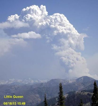
Little Queen Fire, August 18, 2013

Residents of Atlanta, Idaho have been ordered to evacuate by noon today, Monday, because of the 2,000-acre Little Queens Fire burning about four miles north of the town. The majority of the fire is in the Sawtooth Wilderness and Sawtooth National Forest.

The Great Basin Type 2 Team 5 (Wilde) is being reassigned to the fire.

From InciWeb, on August 17:

Jason Greenlee is the Incident Commander, “We will manage the Little Queens Fire as a long term fire. We will monitor the fire to ensure that it does not burn into Atlanta, Idaho and plan and prepare to defend the community if the fire changes direction and moves to the south”. This strategy is being used due to the shortage of resources to fight the fire due to other fires in the area.

In case you’re not familiar with Atlanta, it is 37 miles northwest of Ketchum, ID, and 23 miles northwest of the 104,000-acre Beaver Creek Fire.

California: American Fire, west of Lake Tahoe

American Fire
American Fire. Photo by Todd White.

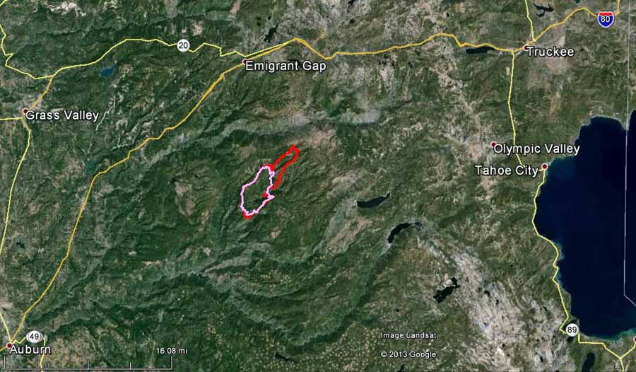
The American Fire was very active during the day on Thursday and well into the night, adding over 2,000 acres as it spread to the northeast up Secret Canyon toward Ford Point and Whisky Hill. The map below shows the location of the 7,367-acre fire.

The fire is 22 miles west of Lake Tahoe, 9 miles south of Emigrant Gap, and 22 miles southwest of Truckee.

map American Fire
The red line is the perimeter of the American Fire at 9 p.m. PDT, Thursday, August 15, 2013. The pink line was the perimeter early Thursday morning. (click to enlarge)

A 10,000 gallon water tank and a 10,000 gallon mobile retardant plant for helicopter operations has been established at the Blue Canyon Airport just south of Interstate 80.

One mining structure has been destroyed and there have been two minor injuries.

The local weather can be monitored at the Seed Orchard weather station west of the fire where the relative humidity was 19 percent at 7:33 Friday morning. The forecast for the fire area calls for 75 degrees, relative humidity of 17 percent, and 13 mph winds gusting up to 20 mph around noon.

Wildfire briefing, August 9, 2013

Fire photos

We found two very impressive photos of smoke columns, on Instagram, here and here, plus a third one on Facebook.

A “row” over death benefits for families of Granite Mountain 19

As the UK-based Reuters news service reported, there is a “row” over the variable benefits that the Prescott Fire Department intends to give to the families of the 19 members of their department that were killed on the Yarnell Hill Fire. The families of the six firefighters classified as full-time will receive additional financial benefits and lifetime health insurance from the city — much more than the 13 firefighters the department puts in the seasonal category.

Arizona House Speaker Andy Tobin is considering calling for a special session of the state legislature to debate a bill that would ensure that firefighters’ families, at least in this case, are fairly compensated when there are fatalities on state-protected land.

A video at Arizona Central describes the tense relationship between the families of the Granite Mountain 19 and the City of Prescott.

If you have not seen them yet, you need to view the video interviews with survivor Brendan McDonough that we posted earlier today.

Preparedness Level raised to 4

Today the National Interagency Fire Center raised the national Preparedness Level to 4, the criteria for which is:

Three or more Geographic Areas are experiencing incidents requiring Type 1 and 2 IMTs. Competition exists between Geographic Areas. Nationally, 60 percent of Type 1 and 2 IMTs and crews are committed.

Today, August 9, is later than last year for moving into PL 4. In 2012 we transitioned into PL 4 on June 27 and again on August 8.

Incident Management Team assigned to Elk Fire

Rich Harvey’s Type 1 Incident Management Team is mobilizing today to the Elk Fire on the Boise National Forest near Pine, Idaho. This morning there were four other Type 1 IMTeams and one NIMO team assigned to the following fires (Incident Commander’s name/Fire name):

  • Schulte/Big Windy Complex in Oregon
  • Kaslin/Silver Fire in California
  • Houseman (NIMO)/Lodgepole in Idaho
  • Poncin/Gold Pan Complex in Montana
  • McGowan/Salmon River Complex in California

There are also 14 Type 2 IMTeams committed.

Silver Fire grows to 16,000 acres in southern California

The Silver fire 60 miles east of Los Angeles has grown to 16,000 acres since it started August 7. The map below shows the fire’s location near Banning and Cabazon. More details about the fire.

Map of Silver Fire,
Map of Silver Fire, at 10:05 p.m. PDT, August 8, 2013. The squares represent heat detected on the fire. The red line is last month’s Mountain Fire which is contained. (click to enlarge)

Unfortunately another recent major fire in Arizona was also named “Silver”.

Smokey’s birthday

Smokey Bear is 69 years old today.

A quick glance at the image on the video below, before it starts, and you understand why some small children are scared when they see someone in a Smokey Bear costume.