Firefighters on the KNP Complex of fires working to contain slop overs across Generals Highway

The fire in Sequoia National Park has burned more than 81,000 acres in California

8:03 a.m. PDT Oct. 6, 2021

KNP Complex of fires, near Eshom
KNP Complex of fires, near Eshom Campground, Oct. 4, 2021. InciWeb.

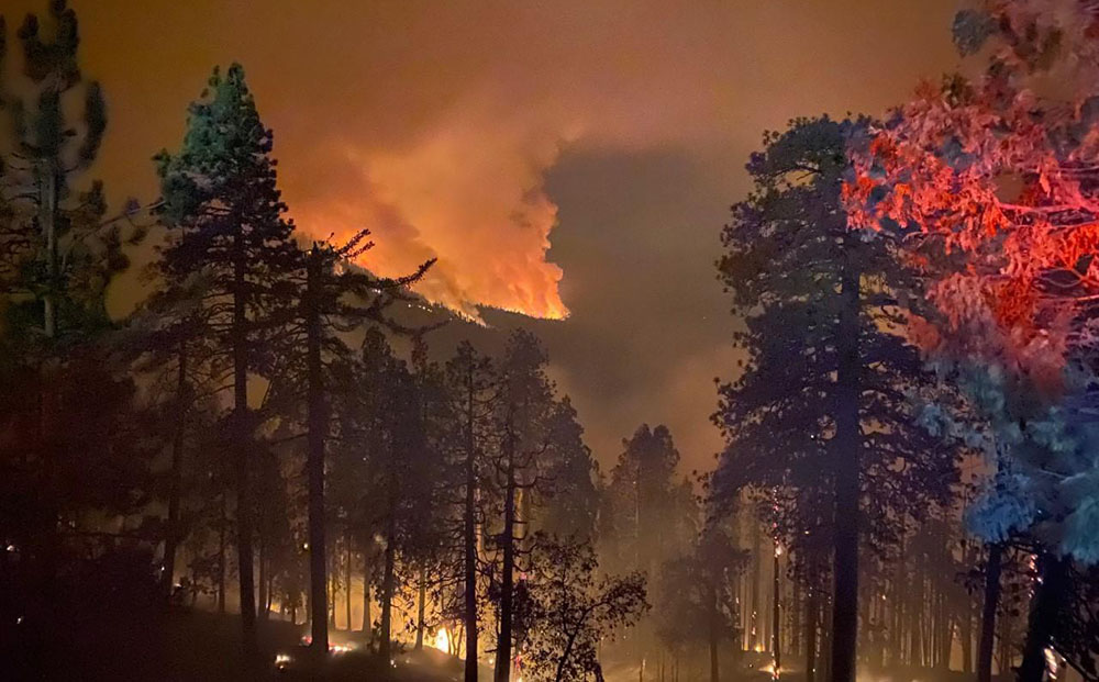
On the KNP Complex of fires in Sequoia National Park in Southern California, the smoke, which has limited the use of firefighting aircraft for days or weeks, cleared by mid-morning Tuesday more than it had in recent days which allowed the use of some aviation resources both on the north and south ends of the fire. An increase in relative humidity has slowed the spread for the last two days, allowing firefighters to construct direct fire line near the fire’s edge where conditions permit.

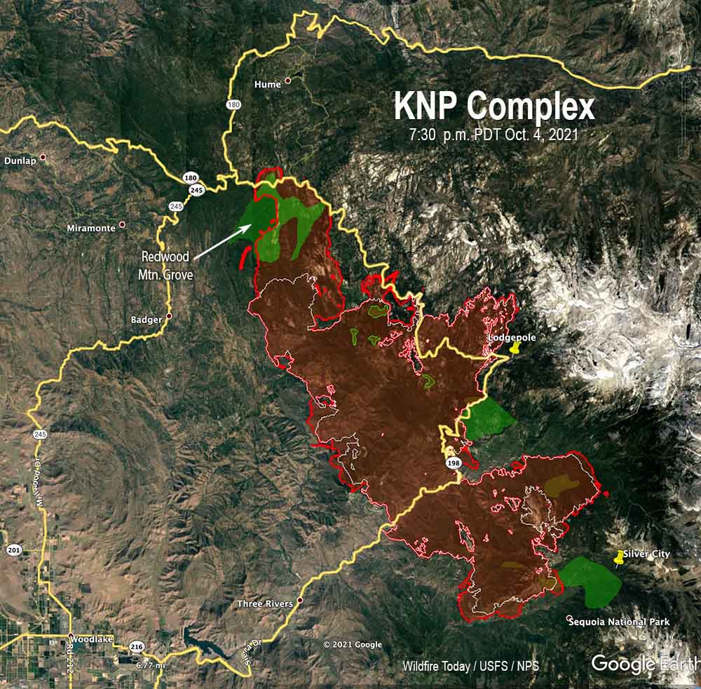
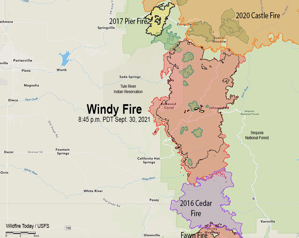
The blaze was mapped Tuesday evening at 81,473 acres, an increase of more than 20,000 acres in the previous 48 hours.

KNP Complex map, 8:50 p.m. Oct. 5, 2021. The white line was the perimeter on the evening of Oct. 4. The green areas are the APPROXIMATE locations of groves of giant sequoia trees.

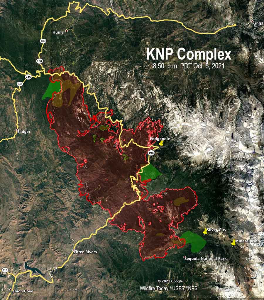
Approximately 550 acres have burned north of Generals Highway one mile southeast of the community of Wilsonia. Tuesday evening Operations Section Chief Chad Rice said hand crews and dozers are constructing line around that large slop over, tying in to old fire lines, fuel treatments, and roads where they exist. That should be complete “in a few shifts,” Mr. Rice said.

A large number of firefighters are working in Grant Grove and Wilsonia to make them easier to defend if the fire spreads into those areas.

KNP Complex map, north side
KNP Complex map, north side, 8:50 p.m. Oct. 5, 2021. The white line was the perimeter on the evening of Oct. 4. The green areas are the APPROXIMATE locations of groves of giant sequoia trees.

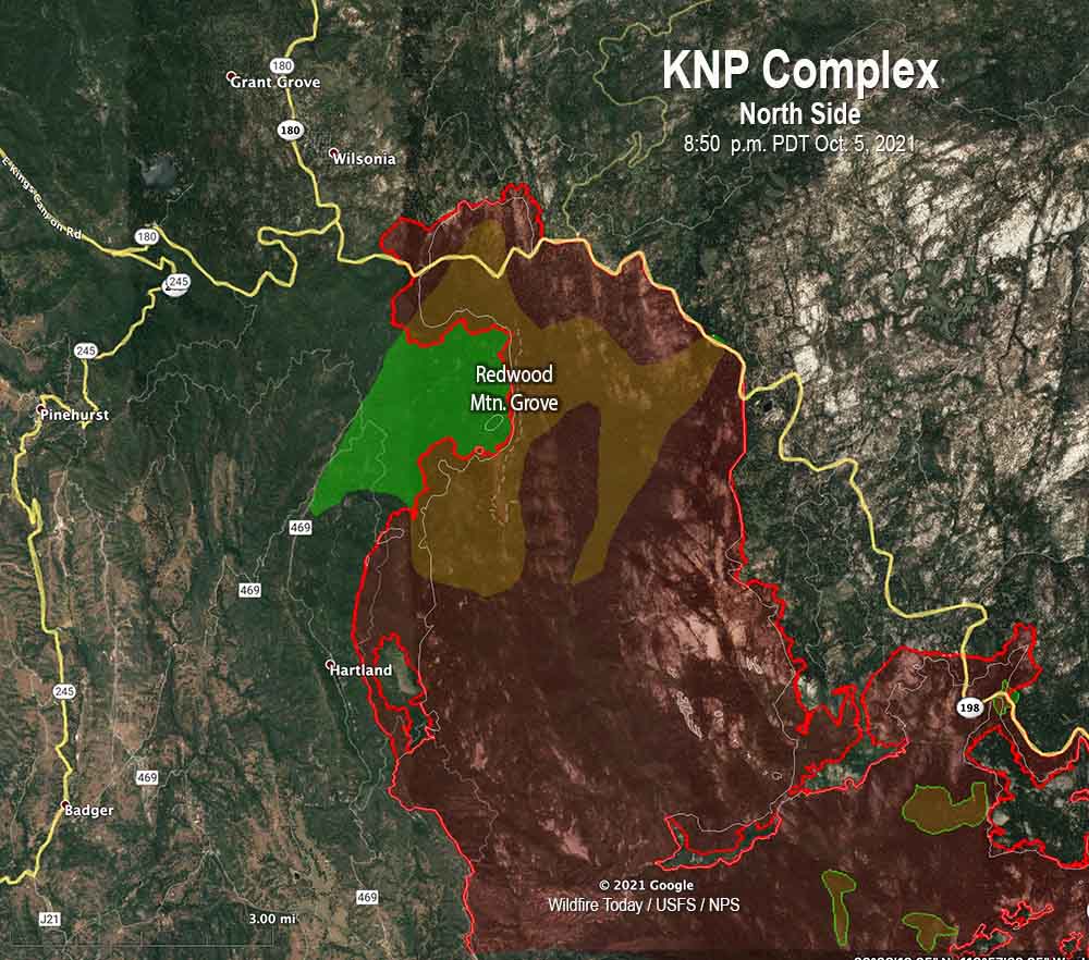
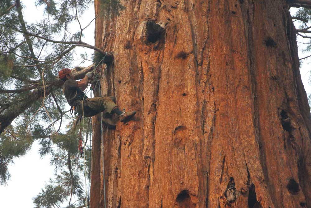
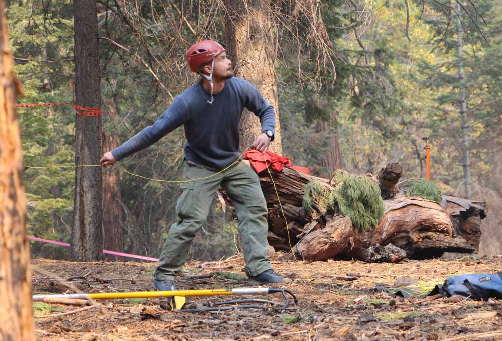
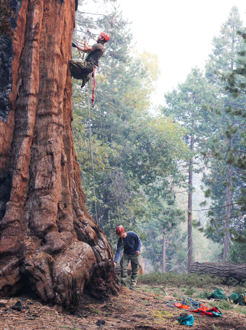
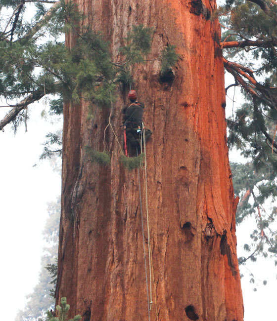
The incident management team has not released information about the mortality of the giant sequoias in the Redwood Mountain Grove after the fire spread rapidly through the area on October 4. It is the largest grove on Earth of the trees and contains the world’s tallest giant sequoia, 312 feet (95 meters). The huge trees with bark up to a foot thick are normally fire resistant and can live for more than 3,000 years old if climate change was not creating multi-year droughts and extremely low fuel moistures. Last year the Castle Fire, just to the south, destroyed an estimated 7,500 to 10,600 large sequoias with trunk diameters of more than four feet, which was 10 to 14 percent of all large sequoias across the tree’s natural range in the Sierra Nevada.

Near Stony Creek Lodge and Cabin Creek on the northeast side of the fire there is a 200-acre slop over across Generals Highway that firefighters are working on.

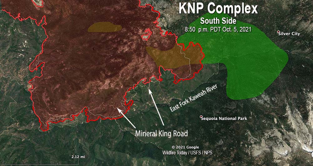
On the south side, the fire has crossed Mineral King Road in several places, which in that steep topography raises the level of difficulty in stopping the spread in that area. It has not yet crossed the East Fork of the Kaweah River, but Operations Section Chief Chad Rice said he expects it will cross to the south side. The terrain, fuels, fire behavior, and the one-lane road so far have made it unsafe for fire crews to work in some locations on the south edge of the fire, Mr. Rice said. For several hours on Tuesday a boulder the size of a car rolled down onto the road, blocking it until the boulder could be removed.

KNP Complex map, south side
KNP Complex map, south side, 8:50 p.m. Oct. 5, 2021. The white line was the perimeter on the evening of Oct. 4. The green areas are the APPROXIMATE locations of groves of giant sequoia trees.

There are no reports of any residences being destroyed. Resources assigned to the fire include 38 hand crews, 111 fire engines, and 16 helicopters for a total of 1,866 personnel.

Evacuation details are available on a map and at the  Tulare County Sheriff’s Facebook Page.

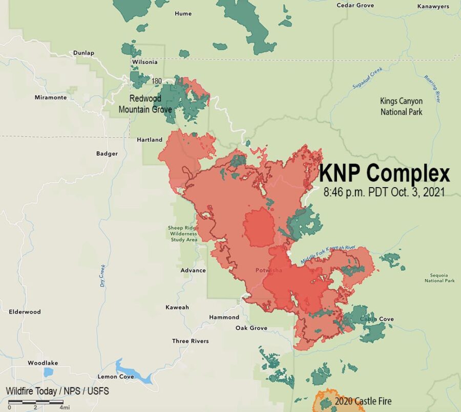
Lightning started two fires on September 9, the Paradise and Colony Fires, which later merged to become the KNP Complex of fires. It is burning in the Sequoia and Kings Canyon National Park and Sequoia National Forest and is being managed as a full suppression fire.

KNP Complex of fires crosses Generals Highway east of Wilsonia, California

Burns most of the Redwood Mountain Grove, the largest grove of giant sequoia trees on earth.

 1:30 p.m. PDT Oct. 5, 2021

KNP Complex map north side Wilsonia
KNP Complex map, north side. The red line was the perimeter at 7:30 p.m. Oct. 4, 2021. The green areas are the APPROXIMATE locations of groves of giant sequoias.

On Monday the KNP Complex of fires in Sequoia National Park, pushed by 55 mph winds, crossed Generals Highway about a mile east of Wilsonia. The extreme fire behavior forced firefighters to temporarily move to safer locations. The additional growth resulted in the fire becoming well established in Redwood Creek and burning much of the Redwood Mountain Grove, which is the largest grove of giant sequoia (Sequoiadendron giganteum) trees on earth. It contains the world’s tallest giant sequoia, 312 feet (95 meters). The amount of mortality of the sequoias is unknown at this point.

At least two very large pyrocumulus convection columns of smoke were seen Monday on the north side of the fire that rose to more than 32,000 feet, indicating extreme fire behavior.

This additional growth threatens Hartland, Quail Flat, Wilsonia, and Grant Grove. Firefighters are doing what they can to provide structure protection in these locations.

KNP Complex map
KNP Complex map. The red line was the perimeter at 7:30 p.m. Oct. 4, 2021. The white line was the perimeter about 48 hours before. The green areas are the APPROXIMATE locations of groves of giant sequoias.

The KNP Complex has burned 79,382 acres. Resources assigned include 27 hand crews, 90 engines, 35 water tenders, 18 dozers, and 13 helicopters for a total of 1,566 personnel.

On the southern side of the fire Monday, firefighters worked along Mineral King Road to contain the spot fires from Sunday night. They also provided structure protection in Silver City and the Mineral King area. Helicopters were able to support ground resources with bucket drops on Monday after the smoke cleared enough to safely fly.

On Tuesday crews are working on control lines to keep the fire out of the communities near the Redwood Mountain Grove on the north side of the blaze.

KNP Complex of fires
KNP Complex of fires. Uploaded to InciWeb Oct 4, 2021.

Large firing operations underway on KNP Complex of fires

Sequoia National Park in California

4:13 p.m. PDT October 4, 2021

The firing operation on the north side of the KNP Complex along the Generals Highway/180 southeast of Wilsonia is moving along rapidly. It appears to have begun on Saturday, and by the time of the mapping flight Sunday night had spread half a mile to a mile south of the highway. It is now moving through the Redwood Mountain Grove, which is the largest grove of giant sequoia (Sequoiadendron giganteum) trees on earth. It contains the world’s tallest giant sequoia, 312 feet (95 meters).

Monday morning @mn_storm reported that a very large pyrocumulus convection column of smoke had been created that rose to 33,000 feet where the temperature reached -62°F. Monday afternoon @mm_storm said another pyrocumulus had reached 40,000 feet.

Nate Bogenschutz, an information officer for the fire, told Wildfire Today at 4 p.m. PDT Monday that the firing operation had remained within it’s intended boundaries and had not crossed Generals Highway/180. He said fire activity had increased around most of the fire today.

Our hope is that most of the smoke is not coming from the Redwood Mountain Grove and the tactical firing operation, and that the operation does not destroy large numbers of giant sequoia trees, which can live for more than 3,000 years old if climate change was not creating multi-year droughts and extremely low fuel moistures.


10:27 a.m. PDT Oct. 4, 2021

Map of the KNP Complex of fires
Map of the KNP Complex of fires, 8:46 p.m. Oct. 3, 2021. The dark red line was the perimeter on October 1. The green areas are groves of sequoia or redwood trees.

A drying trend over the last several days has led to an increase in fire behavior on the KNP Complex of fires in the Sequoia National Park in California. This has been especially apparent in lower elevations on the south and west sides where brush is the primary component of the vegetation.

Smoke trapped under an inversion has socked in the drainages and has limited the use of conventional aircraft for the last few days. However drones with infrared technology which can see through smoke have been flying, providing intelligence about the spread of the fire.

Map of the KNP Complex of fires
Map of the north side of the KNP Complex of fires, 8:46 p.m. Oct. 3, 2021, showing two firing operations. The dark red line was the perimeter on October 1. The green areas are groves of sequoia or redwood trees.

Two large firing operations are ongoing. On the north side near the Heartland community firefighters are working to keep the fire in Redwood Canyon, an area that is very steep and rugged all the way north to the Redwood Mountain Grove and the Generals Highway/180. The canyon is too steep and inaccessible and has multiple hazards, making it unsafe for firefighters. Saturday night a firing operation began at the highway to get the fire to back down the slope to the south, creating a buffer along the highway. By Sunday night fire personnel had ignited along four miles of the highway.

A few miles to the southeast, another firing operation is working north along the Generals Highway, starting near Dorst Campground. After it proceeds for a few miles, it will leave the highway to get onto a trail system to the west, closer to the fire, and will eventually meet up with the other operation which is working south off the highway.

KNP Complex of fires, Inyo Hotshots,
KNP Complex of fires, Inyo Hotshots, Sept 29, 2021. InciWeb.

The incident management team is having difficulty obtaining the firefighting resources they need. This is due to several reasons, including the fact that some seasonal employees on hand and engine crews are reaching the end of their employment periods, and other fires are competing for the same types of resources.

Sunday night strong winds on the south side of the fire caused a spot fire across Mineral King Road which prompted an evacuation order for Crest, Sierra King, Hammond, and Oak Grove. Evacuation details are available on a map and at the  Tulare County Sheriff’s Facebook Page.

Repeater installation KNP Complex of fires
Helicopter waits for technicians installing a radio repeater on the KNP Complex of fires, Oct. 2, 2021. InciWeb.

Firefighters climb giant sequoias on the Windy Fire

The blaze has burned more than 92,000 acres in California.

9:02 a.m. PDT Oct. 3, 2021

smokejumpers climb giant sequoia tree Windy Fire
Rick Rataj and Tyler Anderson, USFS California Smokejumpers, climb a giant sequoia to investigate an area on the tree that is burning. Windy Fire, Sept. 30, 2021. BIA photo by Laura Scott.

Smokejumpers who usually arrive at a fire by parachute have climbed at least one of the giant sequoia trees on the Windy Fire in California to investigate areas on the tree that were burning. The initial reports were that they would climb an adjacent tree and use a fire hose to apply water onto the burning tree. Smokejumpers are trained to climb trees in order to retrieve hung up chutes, but this is not a common task for them, climbing a tree that is burning. Usually they simply cut it down.

But these huge trees that can live for more than 3,000 years have been suffering during the multi-year drought  and dry windy weather that has caused very low fuel moistures and intense fires that can penetrate the foot-thick bark. Last year the Castle Fire, just to the north (see map below), destroyed an estimated 7,500 to 10,600 large sequoias with trunk diameters of more than four feet, which was 10 to 14 percent of all large sequoias across the tree’s natural range in the Sierra Nevada.

Windy Fire map
The red line on the map was the perimeter of the Windy Fire at 7:30 p.m. Oct. 2, 2021. The black line inside that, was the perimeter about 48 hours before. The darkest green areas are groves of giant sequoias.

The 92,473-acre Windy Fire has not spread as much in the last two days as it did earlier. Most of the additional growth was on the west side in and south of the Tule River Indian Reservation. During the Saturday night mapping flight the only large area with intense heat (dark red area on the map) was on the reservation.

Most of the north one-third of the fire has contained fireline, as do some of the areas around California Hot Springs, Pine Flat, and Sugarloaf Village but there is still work to do west of Fairview, on the Tule River Indian Reservation, and other locations near Sugarloaf Village.

Very dry daytime and nighttime conditions are expected to persist into early next week. On Sunday, the Kern River drainage will be very prone to strong winds, with gusts of 25–30 miles per hour; elsewhere, gusts will be up to 20 miles per hour. The result will be several hours of near-critical to critical fire weather conditions along the Kern River valley and adjacent slopes.

smokejumpers climb giant sequoia tree Windy Fire
Rick Rataj and Tyler Anderson, USFS California Smokejumpers, utilize a “bigshot” to launch ropes into the branches of a giant sequoia tree so they can climb up to investigate heat left by the Windy Fire on September 30, 2021. BIA photo by Laura Scott.
smokejumpers climb giant sequoia tree Windy Fire
Rick Rataj and Tyler Anderson, USFS California Smokejumpers, climb a giant sequoia to investigate an area on the tree that is burning. Windy Fire, Sept. 30, 2021. BIA photo by Laura Scott.
smokejumpers climb giant sequoia tree Windy Fire
Rick Rataj and Tyler Anderson, USFS California Smokejumpers, climb a giant sequoia to investigate an area on the tree that is burning. Windy Fire, Sept. 30, 2021. BIA photo by Laura Scott.

At least two dozen giant sequoia trees destroyed in Windy Fire

Smokejumpers climbed one tree to knock down fire in upper limbs

11:33 a.m. PDT Oct. 1, 2021

Windy Fire map 8:45 p.m. PDT Oct. 1, 2021
Windy Fire map at 8:45 p.m. PDT Sept. 30, 2021. The green areas are giant sequoia groves. The black line inside the Windy Fire was the perimeter on Sept. 27, 2021. The “Fawn Fire” should be labeled “French Fire”.

Some of the giant sequoia trees that can live for more than 3,000 years  are being killed in the Windy Fire which has burned about 89,800 acres east of Porterville in Southern California. The huge blaze is burning in Tule River Indian Reservation; the Sequoia National Forest, including the Giant Sequoia National Monument; and Tulare County and state responsibility areas.

The multi-year drought has led to extremely dry fuel moistures which is causing wildfires in California and other areas to burn with unusual intensity, making even some of the giant sequoias with bark up to a foot thick susceptible to wildfires burning under these conditions.

The giant sequoias are found in groves, seen as green areas on the map above.

CNN is reporting that Garrett Dickman, a wildfire botanist with Yosemite National Park who is leading personnel protecting the big trees, said an early assessment indicates that at least 29 of them have died so far.

From CNN:

While the assessment is just beginning, there’s already grave concern. The center of Long Meadow Grove managed well, thanks to work crews did in preparation for the fire, but moving away from that area, Dickman counted 29 sequoias that were “just incinerated” by the blaze.

“There were four of those that had burned so hot that they’d fallen over,” Dickman said, adding one tree burned so badly that it was nearly reduced to just an outline of a tree on the ground. “The majority of the grove is going to survive,” Dickman said, “but there are portions that burned so hot and those trees won’t make it.”

Elsewhere in the forest, Dickman has seen even more devastation. In Starvation Creek Grove, which he says has no modern fire history, he said he saw only “a couple of trees survived.”

“It was one of the groves where we got a few hours of prep work and those trees that we did the emergency prep work around, from the picture, they are the ones that did survive and all the rest of them — it doesn’t look promising,” Dickman said, adding that he plans to assess the grove in the next few days.

Smokejumpers are firefighters who arrive at a fire by parachute. They are trained to climb trees in order to retrieve chutes hung up in trees. Some of them assigned to the fire are going to climb the iconic Bench Tree in the Trail of 100 Giants and use a fire hose to apply water to an adjacent sequoia that has fire burning in some of the upper limbs. This may be unprecedented, or at the very least, it is very uncommon.

The National Park Service reported that, “…preliminary estimates suggest that the 2020 Castle Fire [just north of the Windy Fire, see, map above] killed between 31% to 42% of large sequoias within the Castle Fire footprint, or 10% to 14% of all large sequoias across the tree’s natural range in the Sierra Nevada. This translates to an estimated loss of 7,500 to 10,600 large sequoias (those with trunk diameters of 4 feet or more).”

The Windy Fire was active Thursday, growing by about 1,800 acres, and is expected to be more so on Friday. On Thursday there was significant spotting on the south and west sides.

Crews have documented 14 residences, 12 outbuildings, and 2 commercial structures that have been destroyed.

Resources assigned to the fire include 71 hand crews, 136 engines, 17 helicopters, 23 dozers, and 12 water tenders for a total of 2,500 personnel.

The top priority continues to be the southwest side where crews are making good progress securing containment lines and providing structure defense around Sugarloaf and Sugarloaf Mountain Park north towards Pine Flat and California Hot Springs.

If weather conditions on the northwest side permit, Friday crews will continue a tactical firing operation to help improve containment lines.

On the east and southeast sides helicopters and the Bombardier CL-515 Super Scooper have been dropping water and retardant on the upper ridge to slow the fire’s movement east towards the Kern River.

Tulare County residents can sign up to receive county emergency notifications by registering at AlertTC.com.

Information about evacuations can be found at the Tulare County website.

KNP Complex of fires approaches 50,000 acres

1:30 p.m. PDT Sept. 30, 2021

KNP Complex of fires
KNP Complex of fires, posted Sept. 28, 2021 by IMT.

The KNP Complex of fires in Sequoia National Park in Southern California has grown to 49,349 acres.

In a Thursday morning briefing Operations Section Chief Trainee Clint Remington said the fire on the south side of the Middle Fork is backing down closer to the bottom of the drainage. If it crosses, it could run uphill toward the Giant Forest, one of the larger groves of giant sequoia trees in the park. Firefighters have spent weeks prepping this and other groves, removing fuels, clearing around structures, and installing hose lays.

The fireline between the Giant Forest and Lodgepole has received a lot of attention in recent days and is considered secure and contained, but there is a lot of work left to do on the northwest side of the fire, northwest of Red Fir and west of the Generals Highway.

The west side of the fire where it has moved into lighter fuels, including brush, is looking good, Mr. Remington said.

KNP Complex of fires map
KNP Complex of fires map, 1:30 a.m. PDT Sept. 30, 2021. By Incident Management Team.