Forecast for strong winds closes Highway 50 near Caldor Fire

Fire officials have documented the destruction of 179 residences

8:28 a.m. PDT August 21, 2021

Caldor Fire map
Caldor Fire map. The black line was the perimeter at 8:25 p.m. Aug. 20, 2021. The red dots represent heat detected by a satellite at 3:09 a.m. PDT Aug 21.

The 82,000-acre Caldor Fire southwest of Lake Tahoe is under a Red Flag Warning Saturday for conditions that could push the blaze northeast toward Highway 50.

The updated weather forecast for the fire area Saturday at 4,400 feet is for 14 mph southwest winds beginning at 11 a.m. gusting to 21 mph. The relative humidity will drop from the overnight high of 55 to 60 percent to the high 20s. There will be a 35 percent cloud cover with a high of 75 degrees.

To see all articles on Wildfire Today about the Caldor Fire, including the most recent, click HERE.

About two-thirds of the fire perimeter was active enough Friday night and early Saturday morning for satellites to detect intense heat.

Firefighters reported that winds decreased during the night and spot fires continued to become established in the dense timber stands and clear cuts due to the large amount of extremely dry dead and down material. The increase in relative humidity during the night allowed crews to conduct firing operations.

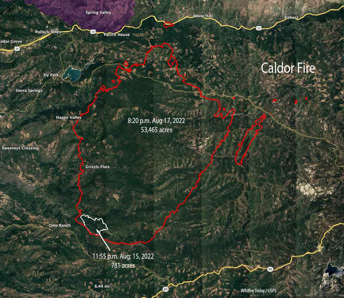
On the east side, satellites detected heat at 3:09 a.m. north of the Omo Ranch, and south, east, and northeast of Jenkinson Reservoir. The fire was also very active on the entire east side near Morrison, Iron Mountain, Iron Mountain Ridge, Voss, Meiss, and Caldor. At that time the fire was less than a mile south of Highway 50 at Riverton, and about two miles south of the highway near Kyburz. On the south side, satellite data overnight detected it was two miles north of Highway 88 at the closest point, Gold Note Ridge.

Crews have documented 179 residences that have been destroyed. Approximately 15,000 remain threatened.

Resources assigned to the fire Friday evening included 28 crews, 142 fire engines, and 20 helicopters for a total of 1,558 personnel.


8:27 p.m. PDT August 20, 2021

Caldor Fire map
Caldor Fire map. The red dots represent heat detected by an aircraft at 2:48 p.m. PDT August 20, 2021. The fire perimeter was mapped earlier.

With strong winds in the forecast for Saturday officials have closed a portion of Highway 50 near the Caldor Fire which has burned over 75,000 acres 18 miles southwest of Lake Tahoe in California.

The closure began at 4:30 p.m. Friday. Highway 50 will be closed in both directions from the Sly Park Road exit to Twin Bridges. It will be open between Meyers and Twin Bridges for local residents only who reside between Meyers and Twin Bridges. These residents will be subject to providing identification and proof of residency. No traffic will be allowed west of Twin Bridges. (This information was acquired at 7 p.m. PDT Friday, Aug. 20, 2021, and could change.)

At 3 p.m. Friday the north edge of the Caldor Fire was about a half mile south of the highway. (See the map above.) A Red Flag Warning will be in effect Saturday from 11 a.m. through 8 p.m. The weather forecast for Saturday at 4,600 feet is for southwest and west-southwest winds beginning at 8 a.m. increasing in strength by 11 a.m. to 16 mph gusting to 25 mph, or 30 mph in some areas. The relative humidity will drop to 25 percent or lower. Skies will be clear with a high of 75 degrees.

Strong winds with no cloud cover and 25 percent humidity could push the fire to Highway 50 and possibly across the roadway. However a dense smoke layer could reduce solar preheating of the fuels and attenuate the spread somewhat. The Hot-Dry-Windy Index for Saturday predicts the area will be below the 50th percentile, which would not indicate extreme spread of a fire. This weather event will be a good test of the Index.

Many areas are under evacuation orders. InciWeb has the details.

On Friday the fire activity increased after noon when the wind began coming out of the south at 6 to 10 mph gusting to 23.

The fire spread is being driven by a heavy component of dead and down fuels and drought-stressed vegetation. Live fuels are cured to levels normally seen in late September, and the vegetation is extremely receptive to spotting. Fuel moistures are historically low.

Fire officials have documented the destruction of 118 residences.

Resources assigned to the fire include 18 crews, 109 fire engines, and 13 helicopters for a total of 1,118 personnel.

USFS engine crews on the initial attack of the Caldor Fire
USFS engine crews on the initial attack of the Caldor Fire, August 14, 2021. USFS photo.

French Fire prompts evacuations near Lake Isabella, California

The fire has burned more than 11,000 acres

9:53 a.m. PDT August 21, 2021

French Fire map
Map of the French Fire. The red dots represent heat detected by a satellite at 2:49 a.m. PDT August 21, 2021.

Friday night the French Fire west of Isabella Lake near Kernville, California grew a bit to the north and southwest while under the influence of a light and variable wind from the south, east, and southeast. (See the map above) The relative humidity which was in the 30s and 40s Friday rose into the 40s again Friday night.

The weather forecast for Saturday calls for stronger winds in the afternoon, 11 mph out of the northwest gusting to 16 mph, with the relative humidity around 40 percent. By 6 p.m. the humidity will begin climbing rapidly, reaching 80 percent by 8 p.m. and remaining above 60 percent the rest of the night.

To see all articles on Wildfire Today about the French Fire, including the most recent, click HERE.

The Incident Management Team reports that the fire has destroyed two structures and burned 11,295 acres. They expect the fire to continue to move toward the communities of Alta Sierra, Alta Sierra Ski Resort, Isabella Highlands Community, Dutch Flat Community, and surrounding areas. Evacuations are still in effect.

Resources assigned to the French Fire Friday evening included 28 hand crews, 52 fire engines, and 5 helicopters for a total of 883 personnel.

French Fire evacuation map
French Fire evacuation map. Accessed at 10 a.m. PDT August 21, 2021. Posted by Kern County Fire Department.

6:22 p.m. PDT August 20, 2021

The French Fire in Kern County, California started Wednesday, August 18, around 4:30 p.m. on the west side of Lake Isabella. (See map above.) On Thursday firefighters were faced with shifting winds driving the fire in several directions, but in the afternoon wind from the southwest and later the south pushed the fire northwest and north.

Friday morning 5 to 10 mph east and northeast winds gusting at 12 to 18 drove the blaze to the west and northwest, but after 3 p.m. 8 to 12 mph winds gusting out of the south at 15 to 18 mph pushed the fire vigorously to the north.

French Fire, looking south-southeast from Shirley Peak
French Fire, looking south-southeast from Shirley Peak at 1:12 p.m. PDT August 20, 2021.

The fire burned over the location of the Shirley Peak camera, but hours later it was still transmitting images of very dense smoke through a dirty lens.

At about 3 p.m. Friday InciWeb reported the following evacuation orders:

  • Wagy Flat Road east to Lake Isabella, between Old State Road south to Keyesville.
  • Keyesville south, from the intersection of Black Gulch Road and Forest Route 26S06, continuing east to Highway 155.

Kern County has posted an evacuation map.

Friday morning the fire was mapped at 4,272 acres, but the push to the north in the afternoon likely added significantly to that number.

Thursday evening resources assigned to the fire included 15 hand crews, 47 engines, and 5 helicopters for a total of 650 personnel. On Friday the number of personnel had increased to 809.

The GOES-17 satellite could easily photograph the smoke plume Friday afternoon as the intensity increased significantly.

French Fire satellite photo
French Fire, photographed by GOES-17 at 5:36 p.m. PDT August 20, 2021.
French Fire 1249 p.m. PDT August 20, 2021
French Fire. The red dots represent heat detected at 12:49 p.m. PDT August 20, 2021. Later in the afternoon the wind shifted and drove the fire to the north. The finger of red dots on the west side turned out to be false positives.

Dixie Fire grows to 678,000 acres near Susanville, California

 Updated at 8:20 p.m. PDT Aug. 19, 2021

At 7 p.m. local time CAL FIRE released an update on the Dixie Fire. The acreage figure was about 22,000 higher than the number from 12 hours earlier, and now stands at 699,666 acres.

At least 659 residences have been documented as destroyed and 137 commercial buildings.

(To see all articles on Wildfire Today about the Dixie Fire, including the most recent, click HERE.)

The fire is being managed by two Incident Management Teams, one on the west side and the other on the east side. In CAL FIRE’s twice daily updates the “Current Situation” section is broken down into the West and East Zones. After closely reading them for a week, it became obvious that they are written by two different people with different views on what information should be included. Below are their updates from today at 7 p.m. These are typical:

“Dixie Fire West Zone: Firefighters continue to build and bolster containment lines on the Dixie Fire. Fire remained active under northeast winds, with spotting and torching contributing to fire growth. Smoke from other fires nearby did limit activity in some places, but not enough to prevent additional growth. Fuel moistures are historically low which is contributing to the critical fire behavior. There are many considerations before allowing an area to be repopulated. A methodical, multi-pronged process of inspection and evaluation must be conducted to ensure the health, safety and welfare of all the residents affected. This process includes guaranteeing roads are safe for travel and basic utilities to infrastructure is secured. Damage assessment is ongoing, and the number of damaged and destroyed structures may change as teams are able to access the fire area safely. Please see below for information affecting your area.”

Dixie Fire East Zone: West Zone and East Zone crews, equipment, and aircraft have maintained aggressive engagement on the portion of the fire near Janesville. Along Honey Lake, the northern edge near fruit grower’s road has remained in its current footprint due to the continued northeasterly winds. Fire line was constructed on the south end from Highway 395 to the Walker fire scar. In an additional priority area, rotary aircraft supported crews in the Genesee Valley this morning when they were able to fly. After aerial retardant application, the spot fire remains at approximately the same footprint of 30 to 40 acres and firefighters are constructing and reinforcing contingency lines to the south. The fire on the north side of Beckwourth Genesee Road is currently backing down the middle slopes and crews continue to construct lines to mitigate impacts to structures in the Genesee Valley.”

Below is the map showing the boundary between the two zones, revised August 16.

Dixie Fire, new East and West Zones

Next, is the satellite photo showing smoke from fires in Washington, Oregon, and California.

Satellite photo, Western Fires at 6:26 p.m. PDT Aug 19, 2021
Satellite photo, Western Fires at 6:26 p.m. PDT Aug 19, 2021.

10:46 a.m. PDT August 19, 2021

Dixie Fire map, northwest area
Dixie Fire map, northwest area. The red areas represent heat detected by a satellite at 3:26 a.m. PDT August 19, 2021. The white line was the perimeter at 8:55 p.m. August 18, 2021. The brown areas had extreme heat when the fire was mapped Wednesday evening.

The spot fire that started five miles east of the Dixie Fire near Highway 395 has grown to about 20,000 acres. It crossed the highway in at least two places but firefighters were able to limit the spread east of the roadway. Approximately five miles of the eastern side of the fire is now alongside Highway 395 west of Honey Lake between Janesville and Milford.

The blaze is still very active in Wilcox Valley and on the west side of the 2019 Walker Fire.

Thursday morning the Incident Management Team reported that the fire had burned 678,000 acres.

Dixie Fire map, northeast area
Dixie Fire map, northeast area. The red areas represent heat detected by a satellite at 3:26 a.m. PDT August 19, 2021. The white line was the perimeter at 8:55 p.m. August 18, 2021. The brown areas had extreme heat when the fire was mapped Wednesday evening.

Westwood has still been spared. Seven miles east of the community the fire has approached Highway 36 but has not grown east past the 2016 Willard Fire. It is six miles west of Susanville.

The northwest area remains very active and continues to march through Lassen Volcanic National Park. I estimate that about 40 percent of the 106,452-acre park has has burned.

The slopover south of Highway 36 east of Mill Creek was very active Wednesday and has burned approximately 2,000 acres. This is 13 air miles west of Chester.

The weather forecast predicts dry, breezy conditions for the next several days. Friday afternoon through Sunday should bring strong winds out of the southwest.

Wildfire smoke and air quality maps, August 19, 2021

Forecast for vertically integrated smoke
Forecast for vertically integrated smoke at 10 p.m. PDT Aug. 19, 2021.

Smoke from wildfires will have serious impacts Thursday in California, Washington, and eastern Canada. The smoke forecast for 10 p.m. PDT is above.

The map below depicts the air quality at 7:26 a.m. PDT Aug. 19, 2021, by AirNow.

Air quality: ozone, PM2.5, & PM10
Air quality: ozone, PM2.5, & PM10 at 7:26 a.m. PDT Aug. 19, 2021. AirNow.

Caldor Fire prompts evacuations east of Placerville, California

It has burned more than 62,000 acres 18 miles southwest of Lake Tahoe

8:57 p.m. PDT August 19, 2021

Caldor Fire map
Caldor Fire map. The white line was the perimeter at 8:20 p.m. August 18, 2021. The red areas represent heat detected by an aircraft at 6:44 p.m. PDT Aug. 19, 2021.

Fire behavior on the Caldor Fire was moderated most of the day Thursday by an inversion, but activity picked up after 3 p.m. It was mapped at 68,630 acres Thursday afternoon.

The map above shows in red the areas of intense heat at 6:44 p.m. Thursday. An aircraft detected a small amount of growth on the northwest and southeast sides, but the fire was more active around the spot fires northeast of the main fire.

To see all articles on Wildfire Today about the Caldor Fire, including the most recent, click HERE.

The Caldor Fire has not moved much closer to Highways 50 and 88. It is 18 miles southwest of Lake Tahoe.


10:02 a.m. PDT Aug. 19, 2021

Caldor Fire map.
Caldor Fire map. The white line was the perimeter at 8:20 p.m. August 18, 2021. The green line was the perimeter 24 hours earlier. The red dots represent heat detected by a satellite at 1:45 a.m. PDT Aug. 19. The brown areas had extreme heat Wednesday evening.

The Caldor Fire east of Placerville, California was active Wednesday but not nearly to the degree seen on Tuesday when it ran for miles to the northeast. Most of the growth Wednesday was on the northeast side. During an 8:30 p.m. mapping flight it was still completely south of Highway 50 except for a spot fire that was suppressed at the highway near Riverton seven miles east of Pollock Pines. The size reported by the Incident Management Team Wednesday evening was 62,000 acres.

Many structures have been destroyed, including in Grizzly Flats, but evaluation teams have not yet been able to get into the burned areas and report the details.

A large number of spot fires on the northeast side near Morrison and Pilliken are in the process of merging to form a large finger of fire two miles south of Kyburtz.

The wind at a weather station northwest of the fire on Pleasant Valley Road (Placer) has been recording winds from the southwest since 11 a.m. Wednesday with the exception of a few hours very early Thursday morning. This accounts for the spread to the northeast. Wednesday afternoon the speed was 4 to 6 mph with gusts at 8 to 12 mph. The relative humidity was in the 40s, pretty high for California in the summer, which limited the movement of the fire.

The forecast for the fire area at 4,700′  Thursday could lead to more active fire behavior than on Wednesday. It predicts 6 to 10 mph winds in the afternoon out of the west-northwest, temperature 85 degrees, and relative humidity in the high teens. Friday will be about the same, but with winds out of the southwest. No chance of rain.

Fire resources assigned to the fire Wednesday evening included 11 hand crews, 61 engines, 20 dozers, 10 water tenders, and no helicopters for a total of 601 personnel. Fire personnel state that the limited number of resources available presents a significant challenge.

The Sacramento Bee reported that Wednesday CAL FIRE transferred 30 fire engines from the Dixie Fire to the Caldor Fire due to a greater need at the time.

“They were released from the Dixie Fire and sent straight over the hill because they were the closest resources available,” CAL FIRE director Thom Porter said.

Quick Reaction Force of helicopters fire Caldor
Quick Reaction Force of helicopters dispatched to Westover Field near the Caldor Fire. Coulson image.

A group of three large helicopters that has been on contract in three Southern California counties since June 15, called a Quick Reaction Force, has been dispatched to Northern California. Carrying from 1,000 to 3,000 gallons each, they all will be working 24/7 and have the capability of dropping water or retardant on a fire at night, as well as the ability to refill while hovering at night. They will be based just north of Jackson at Amador County Airport, also known as Westover Field 18 miles southwest of the Caldor Fire. It is unclear where they will be used — to support the Caldor Fire, other large fires, or for initial attack on new fires.


7:02 p.m. PDT August 18, 2021

Map of the Caldor Fire
Vicinity map of the Caldor Fire. The white line was the perimeter during a fixed wing mapping flight at 8:20 p.m. PDT August 17, 2021. The red areas represent heat detected by a satellite at 1:27 p.m . PDT Aug 18, 2021. The brown area was intense heat Tuesday night.

The Caldor Fire near Pollock Pines in Northern California has grown rapidly since it was reported at 7 p.m. on August 14. With it now covering more than 53,000 acres, the Sheriff’s Offices in Eldorado and Amador Counties have ordered evacuations in the face of what firefighters are calling unprecedented fire behavior. CAL FIRE has a list of evacuation orders.

At 1:27 p.m. PDT August 18, a satellite showed it was 18 miles southwest of Lake Tahoe, 12 miles east of Placerville, 3 miles southeast of Pollock Pines, and was about a half mile south of Highway 50. However, a spot fire was detected at Highway 50 near Riverton.

Map of the Caldor Fire
Map of the Caldor Fire. The white line was the perimeter during a fixed wing mapping flight at 8:20 p.m. PDT August 17, 2021. The red areas represent heat detected by a satellite at 1:27 p.m . PDT Aug 18, 2021. The brown area was intense heat Tuesday night.

On Tuesday structures were damaged or destroyed. Assessment teams will evaluate the areas as soon as the access is safe.

The fire is being driven by heavy drought-stressed fuels at record setting low moisture levels and large amounts of dead and down material in steep drainages that were in alignment with the northeast winds.

Firefighters expect the active fire behavior to continue through Thursday. One of the challenges they are facing is an inadequate number of firefighting resources.

Caldor Fire map, Aug 15 & 17, 2021
Caldor Fire map, August 15 & 17, 2021.

Strong wind forces Dixie Fire to the south

More than 635,000 acres have burned

8:05 a.m. PDT August 18, 2021

Dixie Fire map
Dixie Fire map, northeast area. The red areas represent heat detected by a satellite at 3:45 a.m. PDT August 18, 2021. The white line was the perimeter on the morning of August 17, 2021.

A wind event hit the Dixie Fire Tuesday, and from a direction we have rarely seen since the fire started from a PG&E power line on July 13.

Predominantly from the northwest Tuesday, the winds pushed the fire from Lassen Volcanic National Park three to four miles south. It mostly remained east of Highway 36, but satellite data shows that it likely crossed the road five miles east of Mineral. This growth south of the park alone burned about 13,000 acres.

The Incident Management Team reported Wednesday morning that the total size was 635,000 acres, an increase of 31,000 over the previous update, but it is not clear if that included all of the massive growth over the previous 24 hours.

Their report helpfully included the information that, “California historically experiences some of the most devastating wildfires.”

There has been no recent fixed wing perimeter mapping flight, but the satellite data suggests that the fire did not grow much closer to Susanville Tuesday. While much of the north edge backed into the wind and grew closer to Hwy. 36 east of Westwood, the fire has not spread very far into the five-year-old Willard Fire scar.

(To see all articles on Wildfire Today about the Dixie Fire, including the most recent, click HERE.)

On the east side, south of last year’s Sheep Fire, it was very active in Wilcox Valley. South of the valley more of the perimeter spread into the two-year old Walker Fire.

Dixie Fire map
Dixie Fire map, northwest area. The red areas represent heat detected by a satellite at 3:45 a.m. PDT August 18, 2021. The white line was the perimeter on the morning of August 17, 2021.

The most extreme growth Tuesday and Tuesday night was south of Janesville west of Honey Lake where it ran for six miles. Satellite information showed it to be very close to Highway 395 and may have crossed it again.

The specifics about the wind Tuesday are variable due to the broad and complex land area we’re looking at, but on the east side of the fire at the Pierce weather station north of Antelope Lake the wind speed began increasing at 10 a.m. —  10 mph with 17 mph gusts. Between noon and 6 p.m. the sustained winds were 10 to 15 mph with gusts up to 31 mph. The direction was not very consistent, but was generally from the northwest. The wind slowed during the night but picked up again at 4:00 Wednesday morning, 14 mph gusting to 34, this time out of the northeast.

The relative humidity Tuesday and through the night stayed in the twenties, finally rising to 52 percent at 6 a.m. If it had been in the teens Tuesday afternoon the fire would have been even more dynamic.

The east side of Dixie Fire is under a Red Flag Warning Wednesday. The National Weather Service reports that northeasterly winds are expected to persist Wednesday with gusts around 15 to 20 mph in the afternoon. While pushing the blaze to the southwest, it will also help bring improving air quality to many areas, lasting into Thursday and possibly much of Friday. Light westerly winds may bring smoke back into the region Friday afternoon but confidence in that is fairly low right now, the NWS said..

The numbers of confirmed destroyed structures has risen to 653 residences, 134 commercial buildings, and 413 minor structures.

Resources assigned include 533 fire engines, 184 water tenders, 20 helicopters, 84 hand crews, and 199 dozers, for a total of 6,041 personnel.