Documentary about the 1977 Honda Canyon Fire accepted at film festivals

Four firefighters were killed on the fire at Vandenberg Air Force Base in Southern California

Firestorm 77

A documentary film about the 1977 Honda Canyon Fire that killed four people and injured 65 on Vandenberg Air Force Base has been accepted at multiple film festivals. It is  based on the book by Joseph N. Valencia titled Beyond Tranquillon Ridge.

The film, titled Firestorm 77, is available for streaming at the Malibu International Film Festival now. It will also be streaming at the Big Bear Film Summit in Big Bear, California June 11-27).

More information is at the film’s Facebook page.

Mr. Valencia, one of the first firefighters on the fire, served as a technical consultant on the documentary which is adapted from the book.

Here is how Mr. Valencia described the fire to us in an email:

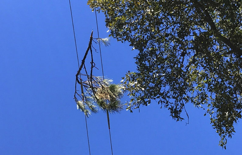
A combination of hurricane-force winds and the snapping of an electrical pole starts the Honda Canyon Fire on Vandenberg Air Force Base, California, early in the morning of December 20, 1977. Over a thousand people consisting of professional firemen and military personnel fight the fire. Outlier winds would increase to over a hundred miles per hour, making the firefight almost impossible. Four fatalities and sixty-five injuries resulted. Ten-thousand acres burn, resulting in significant damage to the military installation infrastructure. Ironically and fortuitously, the fire will be out, a little more than 30 hours later, due to a rain storm-front coming in.

Others working on the film included producer Dennis R. Ford and Christopher Hite, Director of Photography and Cinematographer. Mr. Ford was one of the firefighters on the fire.

The fatalities in 1977 included the Base Commander Colonel Joseph Turner, Fire Chief Billy Bell, Assistant Fire Chief Eugene Cooper, and Heavy Equipment Operator Clarence McCauley.

Below is a two-page brochure about the film:

Continue reading “Documentary about the 1977 Honda Canyon Fire accepted at film festivals”

Sheriff’s office searching for arsonist at Palisades Fire in SoCal

A suspect was arrested Sunday afternoon

Updated at 5:01 p.m. PDT May 17, 2021

Palisades Fire
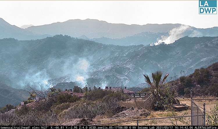
Palisades Fire, looking northwest from Temescal Trailhead at 4:14 p.m. PDT May 17, 2021.

The Los Angeles Fire Department announced Monday morning that an adult male suspected of igniting the Palisades Fire was detained, questioned and then arrested Sunday afternoon by LAFD Arson Investigators. Ralph M. Terrazas, Chief of the Los Angeles Fire Department said in a 10 a.m. press conference on Monday that personnel in a Police Department helicopter observed the ignition of the fire, as well as a second ignition later but lost sight of him in the smoke and dense brush. The suspect was treated Sunday for smoke inhalation.

The intensity and spread of the fire slowed considerably Sunday night and Monday. As predicted, the visibility improved Monday afternoon enough to allow the use of three fixed wing air tankers which dropped retardant to assist firefighters on the ground. They supplemented the work being done by helicopters that have been dropping water. The fire has burned 1,325 acres.

There has been no change in the existing Mandatory Evacuation orders in the County of Los Angeles or the Evacuation Warning in the City of Los Angeles.

No structures have been damaged. One firefighter sustained a minor injury.


Updated at 9:52 p.m. PDT May 16, 2021

Palisades Fire May 16, 2021
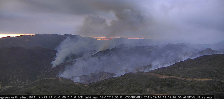
Palisades Fire, looking west from Green Peak at 7:17 p.m. PDT May 16, 2021.

The active investigation into the cause of the Palisades Fire continues. Arson investigators from the Los Angeles Fire Department detained and released one individual, but at 6 p.m. PDT they announced that they are questioning a second person.

The latest information about the fire puts it at 1,325 acres, but these fire updates have been running many hours behind the actual fire activity.

The weather will turn against the firefighters Monday afternoon when the wind out of the southwest will increase to 10 mph and gusts to 16 mph, with relative humidity dropping into the 50s. The cloud cover will decrease after 11 a.m. which may allow the use of fixed wing air tankers.


Updated at 4:04 p.m. PDT May 16, 2021

LA County helicopter departs 69Bravo Palisades Fire
LA County helicopter departs 69Bravo heading toward the Palisades Fire at 11:59 a.m. PDT May 16, 2021. AlertWildfire photo.

At 3:05 p.m. Sunday the Los Angeles Fire Department reported that the Palisades Fire near Topanga, California was mapped at 1,325 acres.

The Department issued a warning at 2 p.m. Sunday for residences in a portion of The Summit community to be ready to evacuate.

An Evacuation Warning is now in effect for the following area (as shown on the map above): Starting at the 1500 block of Chastain Parkway W – all homes north of Chastain Parkway over to Calle Del Cielo (eastern boundary). The warning area includes Calle De Sarah, Calle Bellevista and all homes West of Calle Del Cielo / Ave Ashley up to the hills.

All residents in this area are asked to prepare for a potential evacuation based on the developing fire activity. Secure your valuables, medicines, etc in your car and be prepared if asked to evacuate.


Evacuation warning The Summit
Evacuation warning The Summit, at 2 p.m. May 16, 2021. LAFD map.

The visibility over the fire is not adequate to allow the use of fixed wing aircraft, but helicopters are still assisting firefighters. Departments that sent helicopters include LA FD, LA County, Ventura County, and Orange County.


12:01 p.m. PDT May 16, 2021

Palisades Fire Map
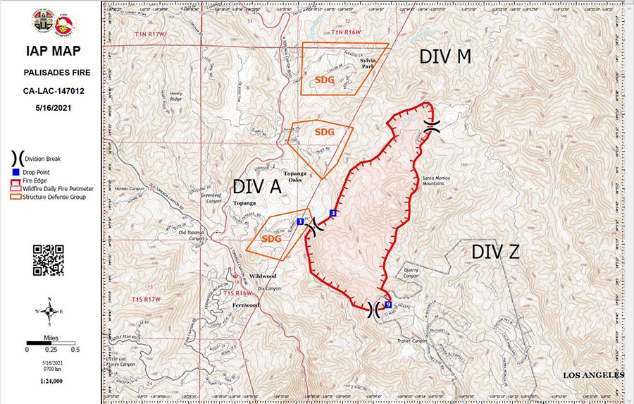
Palisades Fire Map, released Sunday morning May 16, 2021. By LA Co. FD, and LA FD.

No structures have been damaged. One firefighter sustained a minor injury. There are no reported injuries to any civilians.

Continue reading “Sheriff’s office searching for arsonist at Palisades Fire in SoCal”

Palisades Fire is burning northwest of Santa Monica, California

The fire is in Topanga State Park

Updated at 9:23 p.m. PDT May 15, 2021

Palisades Fire map
Map showing the approximate location of the Palisades Fire (the large red arrow) at 7 p.m. MDT May 15, 2021. It is spreading north-northwest.

(To see all articles on Wildfire Today about the Palisades Fire, including the most recent, click HERE.)

Authorities have ordered evacuations for some areas near Topanga as the Palisades Fire continues to spread north-northwest from The Summit community toward Topanga in Southern California. (see map of the Palisades fire above)

The evacuations affect locations east of Topanga Canyon Boulevard between Topanga Community Center and Viewridge Road, as well as those north of Entrada Road, south of Oakwood Drive and east of Henry Ridge Mountain Way.

The fire crossed the Topanga Fire Road at about 7 p.m.  At that time Air Attack orbiting over the fire estimated it had burned more than 750 acres.

Palisades Fire
Palisades Fire looking NE from 69Bravo Helistop at 8:19 p.m. PDT May 15, 2021.

The only bit of good news is the relative humidity will increase Saturday night from the mid-80s to 100 percent along with a 24 percent chance of 0.02 inch of rain. On Sunday afternoon the chance of precipitation decreases to 10 percent and the relative humidity will drop to 60 percent — still high to support the spread of a typical Southern California vegetation fire, but the 60 year old brush near Topanga is showing it can burn in high humidity during the extreme drought currently affecting the area.

The Palisades Fire started in the city limits of Los Angeles, but appears likely to spread into Los Angeles County, if it hasn’t already.


Updated at 6:30 p.m. PDT May 15, 2021

Palisades Fire
Map showing the approximate location of the Palisades Fire in Topanga State Park, May 15, 2021.

The Palisades Fire was reported at about 10 p.m. Friday 5 miles northwest of Santa Monica, CA in Topanga State Park. (See map above.) The blaze is less than a mile north of The Summit, a gated community of upscale homes.

At 5:20 p.m. PDT Saturday firefighters estimated it had burned 150 to 200 acres.

A 10 mph wind out of the south is pushing the fire up hill to the north into a remote area that is difficult for firefighters to access. It is moving at moderate rate of spread, which is faster than I would expect considering that the relative humidity near the fire at Green Peak was high, 79 percent at 5:16 p.m. PDT.

LA County Helicopter 14, a Bell 412 Palisades Fire
LA County Helicopter 14, a Bell 412, refilling at 69Bravo during the Palisades Fire, 5-15-2021

It is spreading through vegetation that has not burned in at least 60 years, according to records from the National Interagency Fire Center. This buildup of old, possibly decadent brush helps explain how it’s burning so well while the RH is high. Live fuel moisture may also be a factor.

Several helicopters and at least a half dozen fixed wing air tankers worked on the blaze until about 6 p.m. when the tankers had to be shut down due to poor visibility. The helicopters will continue to drop water through the night, unless the visibility gets even worse.

MyNewsLA reported that members of the sheriff’s Special Enforcement Bureau were searching for a person suspected of setting the fire. The search was confirmed by Deputy Alejandra Parra of the Sheriff’s Information Bureau.

We will update this article as more information becomes available.

Palisades Fire
Palisades Fire as seen from Green Peak, looking northwest at 4:41 p.m. PDT May 15, 2021.
Palisades Fire
Palisades Fire as seen from 69Bravo Helistop, looking northeast at 4:38 P.M. PDT May 15, 2021.

California power company’s line clearance program criticized by the state

Wall Street Journal reported PG&E’s power lines and equipment started more than 1,500 fires in a 4-year period

Vegetation power line cause faults fires electrically
File photo of vegetation near an electrical line. (Texas A&M Engineering photo)

The California Public Utilities Commission has ordered Pacific Gas and Electric to revise its plan to reduce wildfire ignitions caused by their power lines. The company provides electrical service to areas of Central and Northern California.

PG&E missed a deadline for submitting and gaining approval of their 2021 Wildfire Mitigation Plan. The PUC ordered the company to revise a version they prepared earlier and granted a one-month extension of the deadline.

The PUC’s Wildfire Safety Division says that PG&E is actually spending less money on clearing vegetation from power lines and other equipment, contradicting claims that they are hiring more people to do the work.

Other concerns in the report include quality control and verifying how money spent reduces wildfire risk.

The Wall Street Journal (subscription) reported that investigators attributed more than 1,500 fires to PG&E power lines and hardware between June 2014 and December 2017.

CAL FIRE attributed 12 fires that started in Northern California on October 8 and 9, 2017 to PG&E power equipment.

A search through the Wildfire Today archives found numerous fires attributed to PG&E between 1999 and 2020.  Some of the larger ones are below; it is not a complete or comprehensive list.

  • Zogg Fire, September, 2020, 56,338 acres, destroyed 204 structures, and caused the deaths of four people.
  • Kincade Fire, October, 2019, 77,000 acres, and destroyed 374 structures.
  • Camp Fire, November , 2018, 154,000 acres, destroyed 18,000 structures, and caused the deaths of 84 people. The company pleaded guilty to 84 counts of involuntary manslaughter.
  • Cascade Fire, October 2017, 9,989 acres, destroyed 250 structures, and caused the deaths of five people, including one firefighter.
  • Redwood Valley Fire, October, 2017, 36,523 acres, destroyed 543 structures, and caused the deaths of 9 people.
  • Sulphur Fire, October, 2017, 2,207 acres, destroyed 162 structures.
  • Cherokee Fire, October, 2017, 8,417 acres, destroyed 6 structures.
  • 37 Fire, October, 2017, 1,660 acres, destroyed 3 structures.
  • Blue Fire, October, 2017, 20 acres.
  • Norrbom, Adobe, Partrick, Pythian and Nuns Fires,  October, 2017, burned together, 56,556 acres, destroyed 1,255 structures, and caused the deaths of 3 people.
  • Pocket Fire, October, 2017, 17,357 acres, destroyed 783 structures.
  • Atlas Fire, October, 2017, 51,624 acres, destroyed 783 structures, and caused the deaths of 6 people.
  • Butte Fire, September 2015, 70,868 acres, destroyed a total of 921 structures, including 549 homes, 368 outbuildings, and 4 commercial properties, and caused the deaths of two people.
  • Pendola Fire, October, 1999, 11,725 acres.

Fire within CZU Lightning Complex burns 7 acres

In Big Basin State Park south of San Francisco — may be a holdover from the fire 9 months ago

Basin Fire at 12:25 PDT May 2, 2021
Basin Fire at 12:25 PDT May 2, 2021. From PG&E camera.

On Monday firefighters suppressed a fire that burned within the perimeter of the CZU Lightning Complex of fires. The blaze was in Big Basin Redwoods State Park south of San Francisco and could be a holdover from the 86,502-acre blaze from August, 2020.

When firefighters hiked into the fire it was less than two acres, but with the assistance of aircraft they stopped the spread after it burned about seven acres.

In January several other holdover fires were found in the footprint of the same fire.

Map of Fires in San Mateo and Santa Cruz Counties
Map of Fires in San Mateo and Santa Cruz Counties, Jan. 19, 2021.

There is a chance that considering the numerous very large fires that spread through California and Oregon last year, and with lower than normal precipitation during the winter, other similar holdover fires will be discovered. In many cases since they are within the burn perimeter, they may not be a serious problem. But if they are in a large unburned island, burning embers lofted into the air could ignite spot fires some distance away, perhaps outside the perimeter where there is an abundance of available fuel.

The Park has been closed for the last 9 months after the fire destroyed most of the infrastructure. On August 28, 2020 the Park released a list of the structures that were known to have been destroyed at that time:

  • Historic Park Headquarters
  • Historic (Main) lodge
  • Ranger Station
  • Nature Museum
  • Store
  • Maintenance Shop
  • Multiple park residences, including some Saddle Mountain Property structures
  • Multiple campground bathrooms
  • Gatehouse
  • Bridge between North Escape Road and Gazos Creek Road
  • Many structures at Little Basin
  • Jay Camp Seasonal Housing

Southern Fire burns structures southeast of Julian, CA

CAL FIRE reports it has blackened 5,184 acres

Updated at 4:54 p.m. PDT May 2, 2021

Southern Fire map
Southern Fire map at approximately 2 p.m. PDT May 2, 2021. Data from NIFC/FIRIS.

CAL FIRE has updated size of the Southern Fire near Shelter Valley 8 miles southeast of Julian, California, reporting at 2:35 p.m. Sunday that it had burned 5,184 acres.

As seen in the photo below taken at 4:43 p.m. Sunday four miles away from Monument Peak, the fire from that distance looks pretty quiet.

Southern Fire
The Southern Fire (at the arrow) as seen from Monument Peak, looking north at 4:43 p.m. PDT May, 2, 2021. ALERTWildfire.

Resources assigned to the fire include 20 engines, 8 water tenders, 10 hand crews, and four dozers, for a total of about 200 personnel.


10:00 a.m. PDT May 2, 2021

Southern Fire map 3:18 a.m. PDT May 2, 2021
Southern Fire map, APPROXIMATE LOCATION, from data as late as 3:18 a.m. PDT May 2, 2021. It is based on satellite and FIRIS data. This is APPROXIMATE fire location information, not to be used for planning or decision making.

The Southern Fire in East San Diego County 8 miles southeast of Julian, California has prompted the evacuation of about 500 people and destroyed three structures in Shelter Valley. The residents were relocated from the Butterfield Ranch Campground to Agua Caliente.

At 9:43 a.m. Sunday there was a relatively small amount of smoke visible from Monument Peak which is near Mount Laguna.

Southern Fire May 2, 2021
The Southern Fire as seen from Monument Peak, looking north at 9:43 a.m. PDT May 2, 2021. ALERTWildfire.

At about 9 a.m. PDT Sunday morning CAL FIRE reported that the Southern Fire had burned 2,900 acres. (See map above.) Firefighters battled strong 40 to 60 mph winds during the night, and according to the forecast the weather is going to continue to be a challenge.

A wind advisory is in effect for San Diego County for strong winds through Sunday night. In the fire area the wind is predicted to increase from 23 mph gusting to 36 at 11 a.m. out of the west and west-southwest, to 32 mph gusting to 47 by 5 p.m. It will then gradually decrease by 6 a.m. Monday to 12 mph gusting to 20 out of the northwest. The high temperature on Sunday will be 77 degrees with a minimum relative humidity of 27 percent. The humidity will increase Sunday night to 40 to 55 percent.

Five miles west of the fire and 2,000 higher in elevation at Harrison Park, Cuyamaca State Park, and Julian, low clouds have increased the humidity to 100 percent.

Since the fire was reported at about 4 p.m. on Saturday, it has been spreading generally to the east and southeast.