France’s ‘Zombie Fire’ still alive after 1½ years

The soil under the Hostens Forest in Gironde, France is burning. Not only have numerous rains not been enough to snuff out the flame, but time itself seems to have had no effect.

Four major wildfires over the summer of 2022, totaling around 69,000 acres between July and August, caused the evacuation of 46,000 locals. Authorities suspect human involvement and an investigation has been launched.
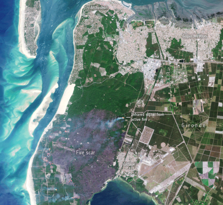
Satellite images showing the impact of the wildfire in Gironde between 12 and 17 July 2022
Satellite images show the impact of the wildfire in Gironde in July 2022. Click for more.

Ever since, the fire has traveled from the surface to underground; it’s still burning despite weeks of rainfall. The underground fuel was partially created by an old lignite (brown coal) mine that produced electricity for the region until it shut down in 1964. After he heard it was partly the reason the fire was still burning, a reader of the Sud Ouest daily newspaper shared images of a field trip he’d taken to the mine as a child.

The continuous fire’s other cause, though, is the land itself. The Landes forest region, where the fires are burning, used to be an extensive marshland filled with moors. That changed in the early 1800s when the area’s sand dunes were stabilized by humans so they could set up plantations and plant a vast pine forest for timber purposes.

The drained, dried-out peatland is as perfect a fuel as you could find for a wildfire. Making matters worse, the artificial forest standing on top of the peat has dried out as well — a result of severe ongoing drought. The combination has forced French authorities to essentially gut the area of all vegetation until all fires are out.

“We are constantly on guard,” said Pascale Got, who handles environmental issues for the Gironde département, according to The Local. “When vegetation starts to grow again, we cut it down. Given the amount that we have cut down so far, I don’t think there will be a resumption of wildfires, unless there is an exceptional drought.”

This kind of continuous fire, or “zombie fire,” isn’t unheard of. A similar fire in Louisiana’s Bayou Sauvage Urban National Wildlife Refuge burned for two months before it was extinguished on December 4. The continual burning plagued the area with “noxious” smoke.

Overwintering fires, wildfires that continue to burn deep in a fuelbed until weather favors flaming behavior and firespread, have also occurred with increased frequency in North America’s boreal forests. Research published in 2021 found that flare-ups from these overwintering fires could partially be predicted by monitoring edges of fire perimeters from the preceding year.

Officials worry that another period of severe drought could start new fires; according to the Connexion, Gironde officials plan to reforest the area in France once the fires have been completely resolved.


Researchers study conditions that can lead to overwintering wildfires

Sometimes called “zombie fires”

Boney Creek Fire in Alaska
Boney Creek Fire in Alaska, July 19, 2019. Photo by Camila Roy, BLM.

Spatiotemporal patterns of overwintering fire in Alaska

By Rebecca Scholten and Sander Veraverbeke
Vrije Universiteit Amsterdam

What are holdover and overwintering fires?
Fires can appear to be out, but retain smoldering combustion deep in the fuelbed and flare up again when the weather favors flaming behavior and fire spread. This phenomenon occurs not infrequently in boreal forests of North America, and presents a well-known challenge to firefighters. Over the last two decades, fire managers noted increasing occurrences where fires survive the cold and wet boreal winter months by smoldering, and re-emerged in the subsequent spring.

Scientists and managers seek better understanding of how these fires sustain during such unfavorable conditions. Fire managers have already started targeting locations where they expect fires to flare up again. However, they are missing detailed information on the environmental and climatic factors that facilitate these fires. This information is crucial to detect fires at an early stage and keep firefighting costs low. A research group at Vrije Universiteit Amsterdam is studying when and where these holdover fires emerge and how their occurrence is tied to specific geographic locations.

Mapping overwintering fires from satellite data
Since 2005, fire managers reported data on 39 holdover fires that survived winter in Alaska. However, the location and emergence date of these fires were used in conjunction with satellite data to develop an algorithm for overwintering holdover detection. From satellite imagery, we can only observe fires that are large enough to generate a considerable amount of heat and burn a large enough area. Consequently, 32 out of 39 reported overwintering fires were too small (all smaller than 11 ha, 25 out of 32 smaller than 1 ha) to be detected from space. The location and emergence date of these small overwintering fires were used for the calibration of an algorithm focused on large overwintering fires. From the remaining seven large reported overwintering fires, our algorithm classified 6 out of 7 as overwintering fire. In addition, our approach revealed 9 large overwintering fires that were not reported by agencies between 2002 and 2018 in Alaska. A results paper is currently in preparation.

The spread rate of smoldering fires is known to be very low, and a smoldering fire would spread only between 100 and 250 m in an entire year (Rein, 2013). So, overwintered fires usually emerge within or close to the previous year fire (Fig.1) and can re-emerge with flaming behavior as soon as favorable burning conditions appear in spring develop in to flaming forest fires before the major lightning-induced fire season. The onset of warm and dry conditions varies from year to year depending on the winter and spring temperatures and precipitation. These variables also shape the regional snowmelt day, which can be inferred from satellite observations. Indeed, our research indicates that holdover fires usually re-emerge within 50 days after the regional snowmelt. Overwintering fires are more likely to occur the year after a large fire
year (Fig. 2).

Overwintering wildfires
Figure 2: Years with a large burned area (grey bars) are more likely to generate
overwintering flare-ups (orange bars) than years with less burned area. Rebecca Scholten and Sander Veraverbeke.

Can we predict where overwintering may re-emerge?
It is not only important to know when these fires emerge, but also where. We therefore analyzed spatial drivers of the overwintering fires we detected. Our research indicates that holdover fires are facilitated in those regions of a fire perimeter that had burned deeper into the organic soil the year before. Deep burning is a characteristic of a high severity fire. We also observed that overwintering fires were more likely to emerge in lowland areas with black spruce-dominated forest. Overwintering fires thus have some temporal and spatial predictability. Monitoring the edges of fire perimeters from the preceding year in lowland forested peatlands early in the fire season, and especially after a year with large burned area, may prove beneficial to extinguish flare-ups from overwintering fires before they develop into a large flaming forest fire. This could be a cost-efficient strategy for fire management agencies. In addition, this would preserve terrestrial carbon by safeguarding it from combustion.

This article is from the Alaska Fire Science Consortium’s Fire Science Highlights.

Fire within CZU Lightning Complex burns 7 acres

In Big Basin State Park south of San Francisco — may be a holdover from the fire 9 months ago

Basin Fire at 12:25 PDT May 2, 2021
Basin Fire at 12:25 PDT May 2, 2021. From PG&E camera.

On Monday firefighters suppressed a fire that burned within the perimeter of the CZU Lightning Complex of fires. The blaze was in Big Basin Redwoods State Park south of San Francisco and could be a holdover from the 86,502-acre blaze from August, 2020.

When firefighters hiked into the fire it was less than two acres, but with the assistance of aircraft they stopped the spread after it burned about seven acres.

In January several other holdover fires were found in the footprint of the same fire.

Map of Fires in San Mateo and Santa Cruz Counties
Map of Fires in San Mateo and Santa Cruz Counties, Jan. 19, 2021.

There is a chance that considering the numerous very large fires that spread through California and Oregon last year, and with lower than normal precipitation during the winter, other similar holdover fires will be discovered. In many cases since they are within the burn perimeter, they may not be a serious problem. But if they are in a large unburned island, burning embers lofted into the air could ignite spot fires some distance away, perhaps outside the perimeter where there is an abundance of available fuel.

The Park has been closed for the last 9 months after the fire destroyed most of the infrastructure. On August 28, 2020 the Park released a list of the structures that were known to have been destroyed at that time:

  • Historic Park Headquarters
  • Historic (Main) lodge
  • Ranger Station
  • Nature Museum
  • Store
  • Maintenance Shop
  • Multiple park residences, including some Saddle Mountain Property structures
  • Multiple campground bathrooms
  • Gatehouse
  • Bridge between North Escape Road and Gazos Creek Road
  • Many structures at Little Basin
  • Jay Camp Seasonal Housing

Plane crash kills three while mapping fires in B.C.

A small plane checking a fire that burned last year crashed in British Columbia Saturday May 4 killing three occupants. The pilot of the single engine Cessna 182 and two passengers died in the accident while one passenger survived and is being treated after being flown to a Vancouver hospital by a Joint Rescue Coordination Centre helicopter.

Precision Vectors was under contract to the British Columbia Wildfire Service to use airborne infrared equipment to check fires from 2018 for residual holdover heat that persisted through the winter. Two of the deceased have been identified, both affiliated with the company — Lorne Borgal the CEO and founder of Precision Vectors, and Amir Ilya Sedghi who provided data analysis.

The Transportation Safety Board confirmed that the aircraft went down about 57 miles north of Smithers, B.C.

Our sincere condolences go out to the families, friends, and coworkers.

Medfra Fire survives Alaska winter, burns thousands of acres

Above: The Medfra Fire near the North Fork Kuskokwin River, northeast of McGrath, Alaska. Alaska Division of Forestry photo by Jason Jordet, May 29, 2016.

Most wildfires, if they are not completely extinguished in the summer or fall, do not continue burning over the winter and flare up again the following spring or summer. The Alaska Division of Forestry (ADF) says this appears to have happened on the 16,500-acre Soda Creek Fire 43 miles northeast of McGrath, Alaska. The fire survived the Alaska winter and continues to burn.

The ADF says as of May 30, what is now known as the Medfra Fire, had blackened an additional 2,000 acres, but more recent satellite data leads us to believe it is at least twice that size on Tuesday morning. It is likely, the ADF said, that it will merge with the Berry Creek Fire, another fire that likely survived the winter, three to four miles to the north.

Or the two fires may have already merged by today.

Medfra Fire map
Map showing heat detected by a satellite on the Medfra Fire as late as 2:14 a.m. MDT, May 31, 2016.
From the ADF, May 30, 2016:

…The Alaska Division of Forestry is formulating a plan of attack to protect any structures and Native allottments that may be threatened and utilizing natural barriers to check the fire spread toward the small settlement of Medfra about 20 miles to the southwest. North winds Sunday night kept the fire burning through the night and winds were expected to continue today.

The fire is burning along the north bank of the North Fork Kuskokwim River. One Native allotment and one cabin are threatened by the fire and State Forestry is developing a site protection plan to protect any values at risk.

The Medfra Fire was called in as a smoke report at 10:25 a.m. Sunday. It is suspected to be a holdover fire from last summer’s 16,500-acre Soda Creek Fire, as it originated in the Soda Creek Fire burn scar and spread into an unburned area with fresh fuel. Fueled by gusty north winds, the fire grew rapidly despite water drops from a helicopter and retardant drops from air tankers. By 2 p.m., the fire was estimated at 50 to 100 acres and by 6 p.m. it was estimated at 500 acres. The last estimated at 9 p.m. was 1,650 acres and growing.

Air retardant tankers dropped several loads of retardant on the fire Sunday to keep it north of the river and thus far the fire is burning parallel to the river on the north side. Twelve personnel are working on the fire on the ground, including eight smokejumpers from the BLM Alaska Fire Service. Several crews from Southwest Alaska villages are staged in McGrath and are ready to join the suppression effort when a plan is formulated.

The Berry Creek Fire burning 3-4 miles north of the Medfra Fire is expected to merge with the fire today. The Berry Creek Fire was reported at approximately 8:40 p.m. Sunday by an air retardant tanker working on the Medfra Fire. It too could be a holdover fire as it originated in an old burn scar. It was initially estimated at 5 acres burning in mostly black spruce but it grew to approximately 50 acres within an hour and was estimated at at least 320 acres as of 10 p.m. Tankers dropped two loads of retardant on the fire Sunday night but the intensity of the fire was such that the retardant did not have much of an effect.