What happens when a power company decides to turn off the electricity for millions of residents?

The preemptive power shutoff for 800,000 addresses by Pacific Gas and Electric in Northern California is directly affecting approximately two to four million residents. The power company took this action to prevent their feeble power line system from starting fires during this period of strong winds. Farther south in California, San Diego Gas and Electric has warned residents living at 30,000 addresses that their power could also be turned off this week.

The indirect effects of having no electricity expand to a much larger  population when you consider traffic lights not working, tunnels on highways being shut down, plus the closure of gas stations, schools, and businesses. At some point cellular telephone towers and infrastructure may exhaust their emergency power supply systems, not to mention the batteries in the public’s cell phones.

Firefighters’ communications could be hampered by the disabling of their radio repeaters on mountain tops. Notifying residents of approaching fires and conducting evacuations in order to save lives could be challenging.

All that is the assessment of someone hundreds of miles away. For the thoughts of a person much closer to what is actually happening on the ground, we turn to Rob Carlmark, a meteorologist for ABC10 in Sacramento, who is surrounded by areas affected by PG&E’s power shutoff. Here, with his permission, are samples of what he has been writing on his Twitter account, @rcarlmark:


10:25 a.m. October 9, 2019

So here is what’s happening on the ground in California for the fire weather story. It’s genuinely freaking everybody out. If we get ZERO fires out of this (small miracle) the power shut off will be remembered for a long time. #MorningBlend10

Rob Carlmark
Rob Carlmark photo.

Despite the pretty large media effort by PG&E to warn people of the power outages…many people we are talking to at closed gas stations had no idea. Turns out not everyone…especially in rural areas look at the internet all day. Some of these folks were BLINDSIDED. We have to take them at their word because they are far away from the windiest areas affecting lines or COULD affect lines. Many work far away, and fuel up often. If you are at a gas station…let’s face it you NEED gas and maybe can’t drive 15-20 miles away to get it…or wait in long lines to get gas. They also have an unexpected day off work…maybe cancelled school..kid/kids to pick up and figure out what to do for DAYS with no power. Of course the alternative is having power on…and a well known source for fires active.

This is a tough spot to be in for 100,000s of customers which likely includes million+total in actual population if you extrapolate for households etc.

They are not going to reimburse people for spoiled food since it was planned. If an outage was caused by an extreme event and weather they might…case by case basis.

Also remember a lot of these people just got hit with a non-renewal for home insurance and if they found someone…it costs drastically more. Also remember that many of these people are actively trying to move…sell their home…can’t find insurance for new buyer or are dropping their prices all the time. This is the APEX of stress in some of the most beautiful places you ever could live.

We need to add more places… the Bay area is about to find out today if one of the major tunnels…MAJOR…will have to shut down for power outages at noon. Traffic there is a true daily horror show…and if you find this out…at work you are going to freak.

We haven’t even talked about Southern California…they too will experience massive outage issues potentially…STRONGER winds and LOWER humidity.

WE HAVEN’T EVEN HAD A FIRE YET! If that happens…which the odds are fairly high…it immediately turns into a dangerous life-threatening event with little info, or ways to get info (no power…no gas).

Finally…peak wind will be middle of the night [Wednesday night/early Thursday]. It’s not just about power…there are DOZENS of ways fires start and any fluke accident could set up many communities for a dangerous moment.

If we can get through this…the power might not come back on for a few DAYS in some areas after the fact (no strong winds) while they inspect lines. fire or not this story will continue for many days more.


4:19 a.m. PDT October 10:

Update from what’s going on in California with this fire weather/power outage emergency. We are right in the thick of it and it’s not over yet.

We had a VERY close call in a town called Moraga near the Bay Area overnight. Fire broke out near a nice suburb surrounded by open land…a true urban/wildland interface situation. It was dicey, scary and in the middle of the night…gusts were 35mph+ nearby and evacuations were door to door with no cell service and power shut off.  By the hard work of firefighters and perhaps the advantage of having roads and access the fire is mostly contained and a nightmare scenario has been avoided…for now.

From what we can tell this is an area with a planned power outage and it’s a reminder that a fire can start form dozens of different ways…not just power arcs. We don’t know cause, but since the power was shut off there it’s worth exploring other causes

Supplies are running really low in power outage areas…water, flashlights, generators etc. have been in short supply like a true disaster emergency situation.

Easily the biggest complaint is “It’s not windy at my house…the power should be back on” Gusts near the dams/hydropower/transmission lines though are VERY strong up to 52 mph so upstream impacts are creating downstream confusion
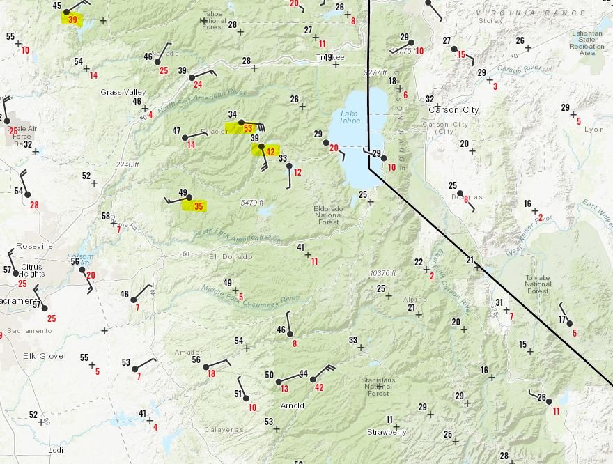
Observed wind speeds in California
Observed wind speeds in California early Thursday morning. Rob Carlmark.

In short…it’s ongoing…people are on edge…every stoplight is a four way stop with traffic issues…people have NO idea when power is coming back…it’s a big deal that is getting bigger today.

I do see the weather changing tonight for many…less wind but still dry so there is an end to this in the weather world…but the power thing…it’s going to be some time.

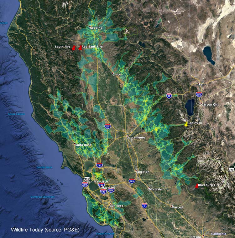
PG&E plans to turn off power to 600,000 addresses to prevent wildfires

This is a response to a forecast for strong winds and Red Flag Warning conditions

PG&E power turn off
Areas in which PG&E expects they will turn off the power Wednesday morning, October 9, 2019.

Pacific Gas and Electric is notifying customers at 600,000 addresses that their electricity will be turned off as a proactive response to a forecast for enhanced wildfire danger. The plan is to throw the switches at 4 a.m. October 9 which could affect millions of people in nearly 30 northern, central, coastal, and Bay Area counties. Based on the latest weather forecasts and models, PG&E anticipates the period of peak winds will occur from early Wednesday morning through midday Thursday. (UPDATE: Tuesday afternoon PG&E raised the number of addresses that will have their power shut off to 800,000)

Since the company’s power lines have caused numerous wildfires in recent years, especially during windy conditions, they have decided to turn off the  power during periods of high fire danger rather than harden their infrastructure to  make it resistant to strong winds.

The weather forecast for some of the areas identified as part of this “Public Safety Power Shutoff” predicts humidity in the teens and north to northeast winds of 15 to 25 mph gusting at 40 to 50 mph beginning late Tuesday night and lasting into Thursday.

PG&E is asking customers to:

  • Update their contact information at pge.com/mywildfirealerts or by calling 1-866-743-6589 during normal business hours. PG&E will use this information to alert customers through automated calls, texts, and emails, when possible, prior to, and during, a Public Safety Power Shutoff.
  • Plan for medical needs like medications that require refrigeration or devices that need power.
  • Identify backup charging methods for phones and keep hard copies of emergency numbers.
  • Build or restock your emergency kit with flashlights, fresh batteries, first aid supplies and cash.
  • Keep in mind family members who are elderly, younger children and pets. Information and tips including a safety plan checklist are available at pge.com/wildfiresafety.

Briceburg Fire burns hundreds of acres north of Mariposa, CA

The fire is burning on both sides of Highway 140 that leads to Yosemite National Park

UPDATED at 1:53 p.m. PDT Oct. 8, 2019

Briceberg Fire
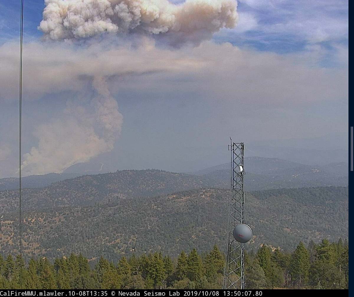
The Briceburg Fire as seen from the Mt. Bullion camera near Mariposa, CA at 1:50 p.m. PDT Oct. 8, 2019.

Activity on the Briceburg Fire  north of Mariposa, California, increased after noon when the smoke column broke through the inversion.


9:31  a.m. PDT October 8, 2019

Briceburg Fire
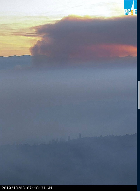
The Briceburg Fire as seen from the Bullion camera near Mariposa, CA at 7:10 a.m. PDT Oct. 8, 2019.
map Briceburg Fire Yosemite highway
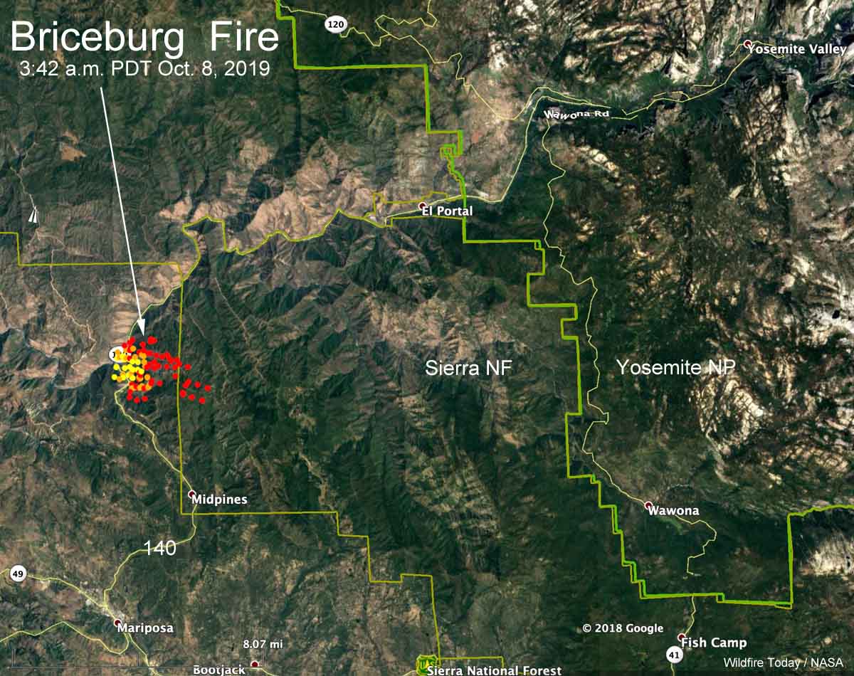
Map showing heat detected on the Briceburg Fire at 3:42 a.m. PDT October 8, 2019. It had become well established inside the Sierra National Forest.

The map above shows heat detected by a satellite on the Briceburg Fire at 3:42 a.m. Tuesday. It indicates growth on the north and east sides, some of which could be firing  operations by firefighters to stop the spread.

CAL FIRE is reported at about 9 a.m. PDT Tuesday morning that it has burned 800 acres. Our very,  very rough unofficial estimate leads us to believe that with the firing operation it could be twice that size.

The fire is on  both sides of Highway 140 just west of the Sierra National Forest 12 air miles southwest of the El Portal entrance to Yosemite, 7 miles north of Mariposa, and one mile west of the Sierra National Forest. At 6:46 a.m. PDT Highway 140 was closed in the Briceburg area.

Below: time lapse video of the Briceburg Fire as seen from the Bullion camera near Mariposa, CA.


Continue reading “Briceburg Fire burns hundreds of acres north of Mariposa, CA”

Wildfire forces closure of Highway 178 northeast of Bakersfield, CA

map Cattle Fire
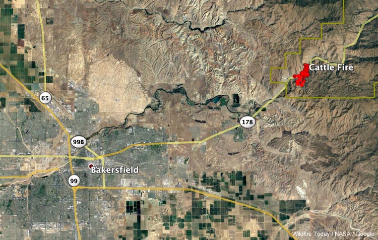
The map shows heat detected on the Cattle Fire by a satellite at 3:48 a.m. PDT Oct. 5, 2019.

Updated at 10:52 a.m. PDT October 5, 2019

A new fire that ignited overnight 9 miles northeast of Bakersfield, California has forced the closure of State Highway 178. The fire, named Cattle Fire, is just inside the boundary of the Sequoia National Forest.

There is a report that the spread of the fire has been temporarily stopped at about 93 acres.

Kern County Fire Department said the highway could be closed through the day on Saturday.

Photos of homes being rebuilt after the Tubbs Fire in Santa Rosa

Map Tubbs, Nuns, Atlas Fires
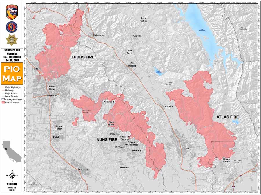
Map of the Tubbs, Nuns, and Atlas Fires. October, 2017.

When the Tubbs Fire burned through Santa Rosa and Sonoma County, California in October 2017, it destroyed over 5,600 structures and burned almost 37,000 acres.

Photographer Kent Porter has documented some of the rebuilding efforts in Santa Rosa with photos taken soon after the fire and again recently.

Generators causing fires during planned power shutoffs

Some power companies in California are turning off the electricity during periods of high wildfire danger to prevent fires

Generator Fire power outage PG&E
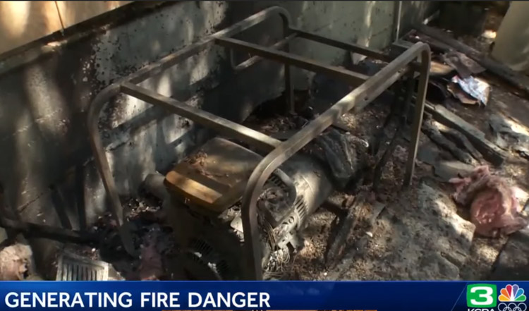
One of the generators that caught fire during PG&E’s planned power outage. Screenshot from video below.

In what Pacific Gas and Electric calls a “Public Safety Power Shutoff”, the company turned off the power to 48,000 customers Tuesday and Wednesday in the Sierra foothills of California.

Following many fires created by their electrical equipment, PG&E began the program to prevent additional fires.  Some residents are using generators when they lose their power to pump water and to keep medical equipment and refrigerators running, but on Tuesday and Wednesday three fires in Nevada County were caused by generators.

PG&E and other companies, including San Diego Gas & Electric, have opted to turn off power to their customers during periods of high fire danger rather than harden their infrastructure to prevent failures that start fires.