The US Forest Service has announced that one of the four people killed in the McKinney Fire in Northern California was Kathy Shoopman, a long-time FS employee. The agency said she died in her home in the community of Klamath River as a result of the fire on July 29, the day the fire erupted.
Ms. Shoopman started her career as a lookout at Baldy Mountain Lookout, west of Happy Camp, in 1974. Since then, she has staffed Lake Mountain Lookout, and most recently Buckhorn Lookout, a post she has held since 1993. She lived in the community of Klamath River for nearly five decades and was a talented artist, gardener, and a devout animal lover.
All four victims lived in Klamath River, which was ordered to evacuate on July 29 as the fire spread rapidly. It has now burned more than 60,000 acres. Ms. Shoopman was the first victim to have been positively identified.
Our sincere condolences go out to Ms. Shoopman’s family, friends, and co-workers.
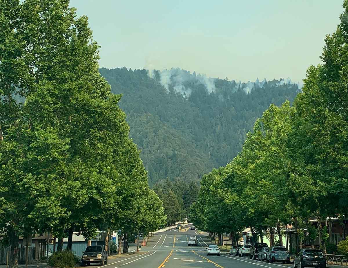
Willow Creek downtown during the Six Rivers Lightning Complex of fires, Aug. 7, 2022. InciWeb.
The wildfires in the Six Rivers Lightning Complex grew incrementally Monday, bringing the total acres burned up to about 8,900 acres when it was mapped at 9:00 Monday night. (See map below)
“Given the full-suppression tactics on this fire, crews will continue to fight fire aggressively in order to keep fire as small as possible,” the incident management team wrote in a Monday evening update. “Personnel are working to find areas to fight fire directly while continuing to provide community defense for Willow Creek, Seely Mcintosh, Salyer Heights, and other areas along the Trinity River.”
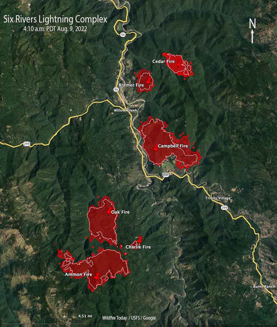
Map of the Six Rivers Lightning Complex. The red shaded areas were the perimeters at 9 p.m. August 8, 2022. The white lines were the perimeters about 24 hours previously. The red dots represent heat detected by a satellite at 4:10 a.m. Aug. 9, 2022.
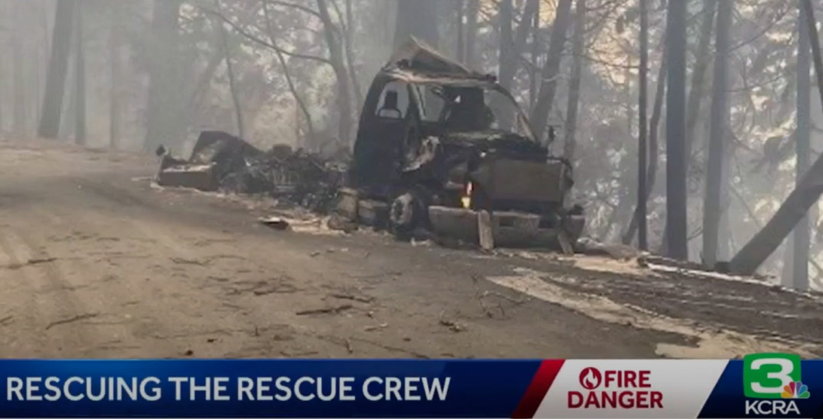
KCRA News reports that two firefighter crew carrier vehicles were destroyed by the fire. Dave Whitt, Chief of the Shingle Springs Band of Miwok Indians Tribal Fire, said “We had almost a million dollars worth of fire apparatus lost but nobody’s hurt, everybody’s safe.”
Two crew carriers burned in the Six Rivers Lightning Complex Fire, Aug. 8, 2022
With the destruction of the vehicles, 15 of the firefighters lost all of the personal gear they brought to the fire except what they were carrying at the time. Gone were sleeping bags, tents, extra tools, clothing, and personal items. Without their gear they were unable to set up tents and camp overnight like the other firefighters, so the Red Cross helped out by treating them like evacuees, providing a place to sleep when they were off duty.
Chief Whitt told Wildfire Today that he expects the US Forest Service compensation/claims process to replace the fire trucks and firefighting equipment. The tribe may assist the firefighters to replace their personal belongings, he said, but was not sure.
Resources assigned to the fire include 14 Type 1 Crews, 8 Type 2 Crews, 11 ST (strike teams) Type 3 Crews, 12 Dozers, 4 Chippers, 11 ST Type 6 Engines, 4 ST Dozers, 11 Type 3 Engines, 7 Water Tender Support, and 2 Feller Bunchers for a total of 525 personnel.
The weather forecast continues to predict moderate and normal conditions.
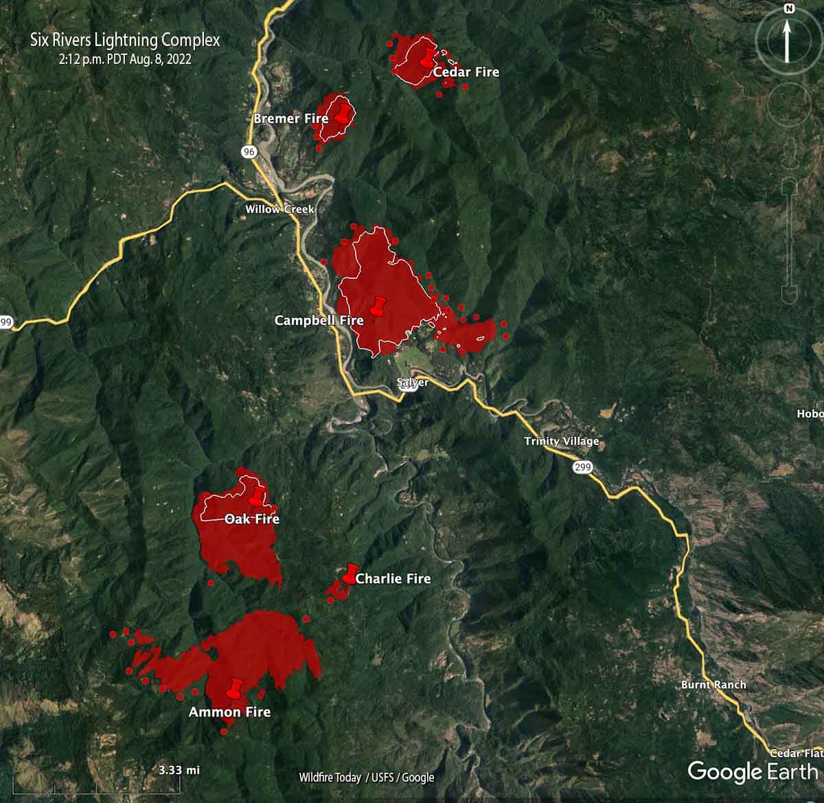
Map looking north from the south end of the Six Rivers Lightning Complex. The red shaded areas were the perimeters at 8:26 p.m. Aug. 7. The white lines were the perimeters about 24 hours before. The red dots represent heat detected by a satellite at 2:12 p.m. Aug. 8, 2022.
The incident management team that assumed command of the Six Rivers Lightning Complex at 6 a.m. Sunday August 7 said on Monday, “This is a full suppression fire. Firefighters will aggressively fight fire whenever it is safe to do so.”
Among their objectives, they intend to keep the fire west of Lone Pine, south of Horse Linto Creek, east of Brannan Ridge, and north of Ammon Ridge.
Humboldt County has issued additional evacuation orders. The current information is at the county’s website.
The fire is in a remote area of northwest California in the Six Rivers National Forest between Redding and Eureka.
The team reported that last year’s snow event left a lot of trees dead and down on the ground. If ignited, it can result in fire behavior that is more substantial than what would usually be anticipated this time of year.
Map of the Six Rivers Lightning Complex. The red shaded areas were the perimeters at 8:26 p.m. Aug. 7. The white lines were the perimeters about 24 hours before. The red dots represent heat detected by a satellite at 2:12 p.m. Aug. 8, 2022.
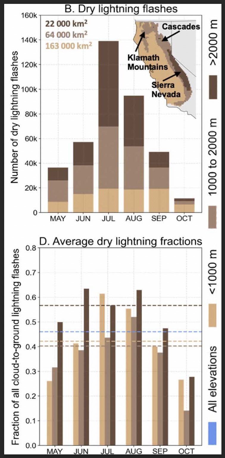
Researchers studied the climatology of dry lightning in California
(B) Total number of dry lightning flashes across three elevation zones (<1000 m, 1000–2000 m, >2000 m) within the domain for each month between 1987–2020. Text indicates the area of each elevation zone, and inset map shows the geographic distribution of the elevation zones and major mountain ranges. (D) The three elevation zones for each month (bars). Dashed lines in (D) indicate the dry lightning fraction averaged across all months for each zone. Blue dashes in (D) represent the dry lightning fraction computed from all months and elevation zones. (From the paper)
A group of six researchers who studied the occurrence and characteristics of cloud to ground lightning in Central and Northern California found that nearly half, 46 percent, was dry, accompanied by less than 0.1 inch of precipitation.
Of course dry lightning is the bane of land managers and is much more likely to ignite a wildfire than a wet thunderstorm. And on the occasions when there are thousands of down strikes, it can overwhelm the capacity to suppress what can be hundreds of fires.
The six scientists used daily gridded lightning and precipitation observations (1987–2020) in combination with atmospheric reanalyses, to characterize the climatology of dry lightning and the associated meteorological conditions during the warm season (May–October) when wildfire risk is highest.
The paper the group produced is available as open source: “Meteorological and geographical factors associated with dry lightning in central and northern California.”
Daniel Swain, a prolific user of Twitter, used the platform today to highlight some of the group’s findings. In the tweet below, click on “read reply” to see more discussion and illustrations.
We assess regional-scale atmospheric conditions favorable for dry lightning in central & northern California (N&C CA), as well as seasonality. We find that nearly half of all lightning strikes in N&C CA are “dry” (accompanied by <0.10 in. of rain). (2/n) https://t.co/DkooDBG0ggpic.twitter.com/1eZpRIG9cX
The six researchers who participated in the project were Dmitri A. Kalashnikov, John T. Abatzoglou, Nicholas J. Nauslar, Daniel L. Swain, Danielle Touma, and Deepti Singh.
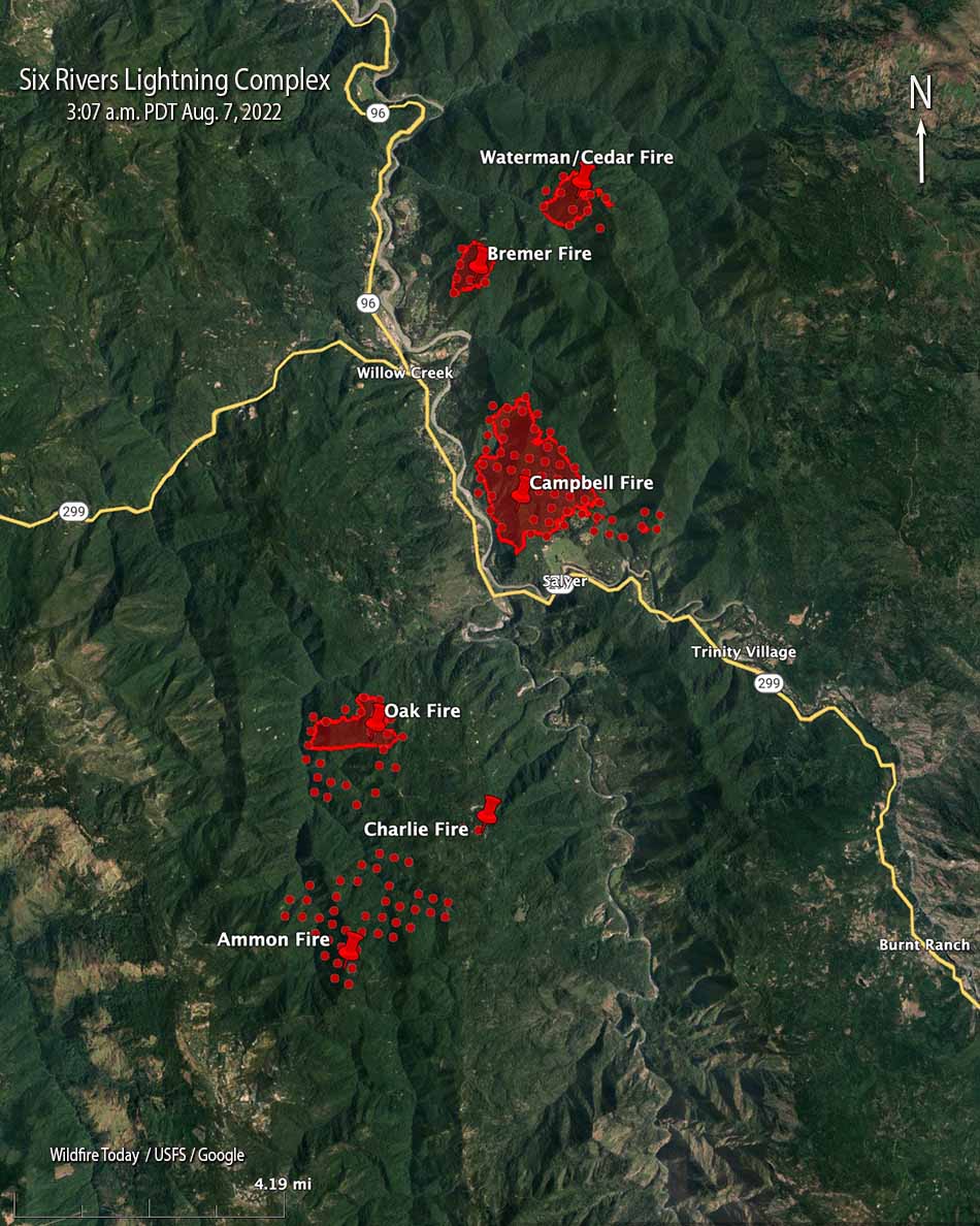
Six Rivers Lightning Complex, north end. The red shaded areas were the perimeters at 8:32 p.m. Aug. 6.
Saturday night at 8:32 a fixed wing aircraft mapped four of the eight fires on the Six Rivers National Forest that comprise the Six Rivers Lightning Complex of fires. The three closest to Willow Creek and east of Highway 299 at that time were the Bremer (213 acres), Campbell (1,526 acres), and Cedar (250 acres).
As can be expected when a dozen fires all start at about the same time in rugged country, there has been some confusion about the names of the fires. We did the best we could to sort that out, but the names on these maps could be subject to change.
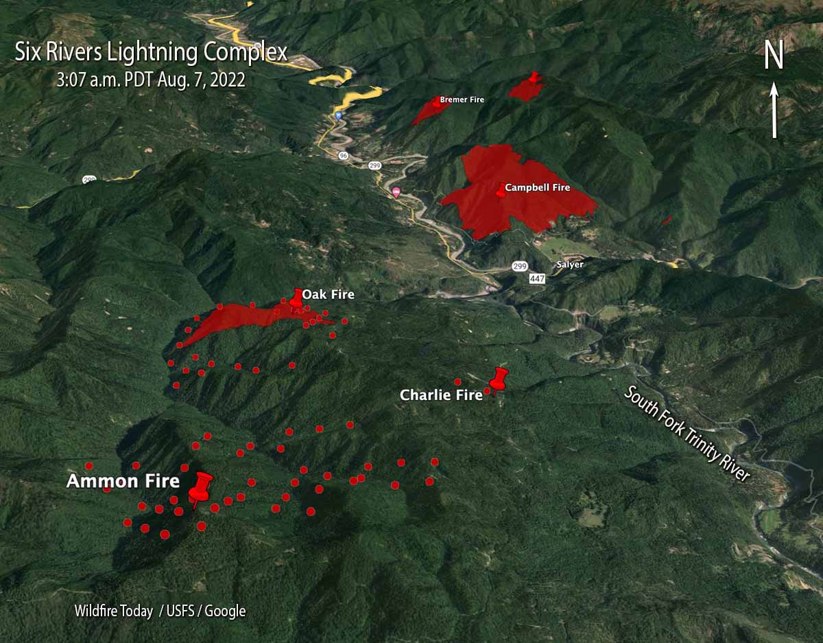
Six Rivers Lightning Complex, south end. The red shaded areas were the perimeters at 8:32 p.m. Aug. 6. The red dots represent heat detected by a satellite at 3:07 a.m. August 7, 2022.
The Type 2 Incident Management Team 11, led by Incident Commander Christopher Fogle, will assume command August 7th at 6:00pm.
Six Rivers Lightning Complex. The red shaded areas were the perimeters at 8:32 p.m. Aug. 6. The red dots represent heat detected by a satellite at 3:07 a.m. August 7, 2022.
Updated at 8:13 p.m. PDT August 6, 2022
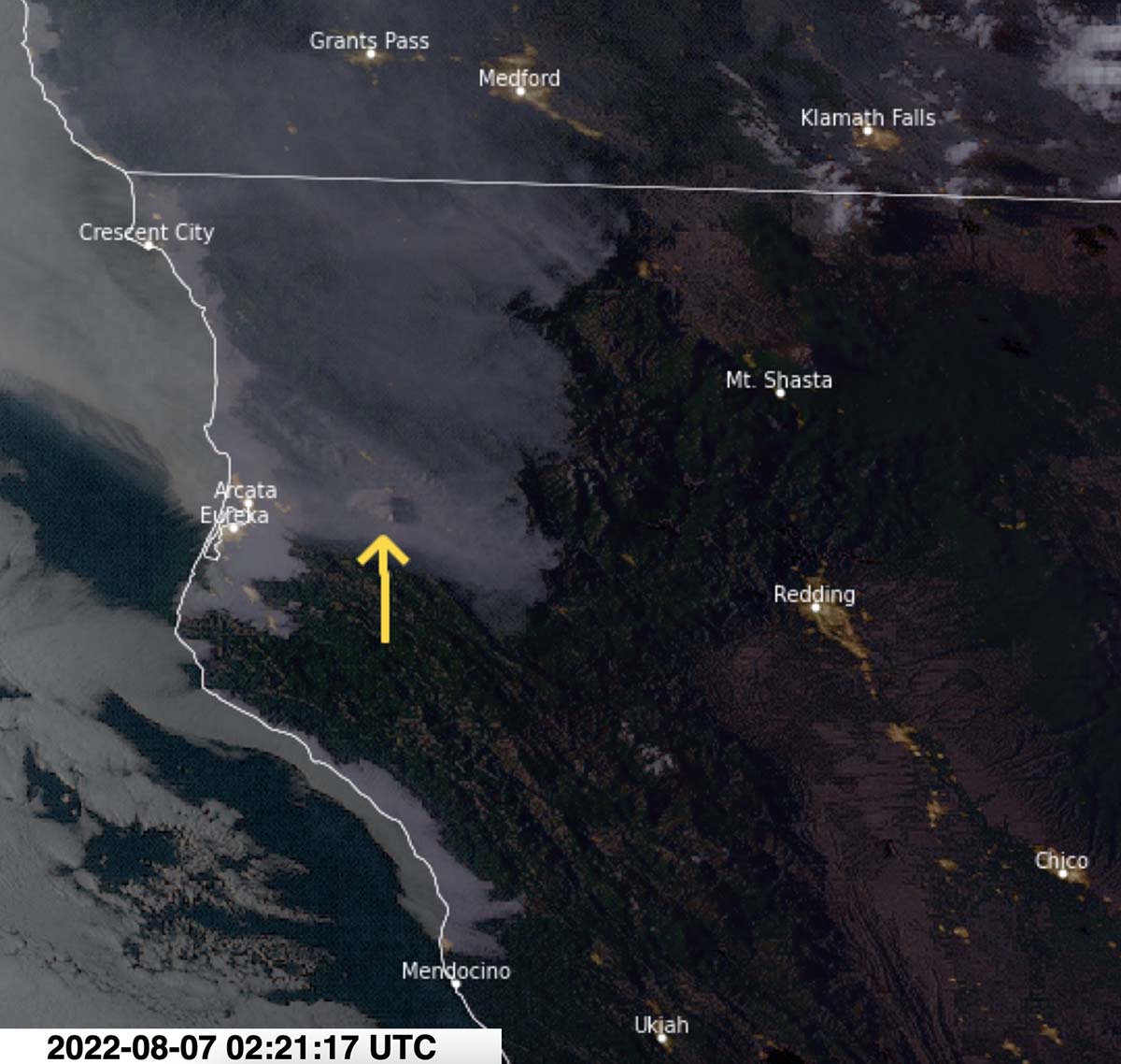
Satellite photo showing smoke from the Six Rivers Lightning Complex of fires at 7:21 PDT Aug. 6, 2022. NOAA.
Updated at 8:02 p.m. PDT August 6, 2022
Campbell Fire, part of the Six Rivers Lightning Complex, taken from Lilys Thai Kitchen by Basho Warson Parks, Aug. 6, 2022.
The Six Rivers National Forest is calling the fires near Willow Creek, California, the Six Rivers Lightning Complex. They released the following information and map on Saturday.
We cannot stress this enough- This is a VERY ACTIVE INCIDENT and is emerging and changing rapidly. Please don’t take notifications lightly and stay informed.
WATERMAN: Approx. 75 acres. Fire is located northeast of Willow Creek on Waterman Ridge Road 7N02 Forest Route 4.
CEDAR: Approx. 80 acres. Fire is located near Waterman Fire.
BREMER: 15 acres. Fire is located northeast of Willow Creek on ridgetop above the Bigfoot Subdivision.
FRIDAY: Fire is located south of Willow Creek ½ mile up Friday Ridge Rd from Hwy 299.
OAK: 200 acres. Fire is located south of Willow Creek. Near FS Road 5N31 and 6N20.
CHARLIE: Contained. Located south of Willow Creek near the Oak Fire and along FS Road 6N20.
CORRAL: Fire is located northeast of Willow Creek on Tish Tang Ridge.
CAMPBELL: Due to fire activity, the Bravo and Campbell fire have merged and is now being called the Campbell fire. Approx. 150 acres. Located south of Willow Creek on the west side of Campbell Ridge above Campbell Ridge above Campbell Ridge Road.
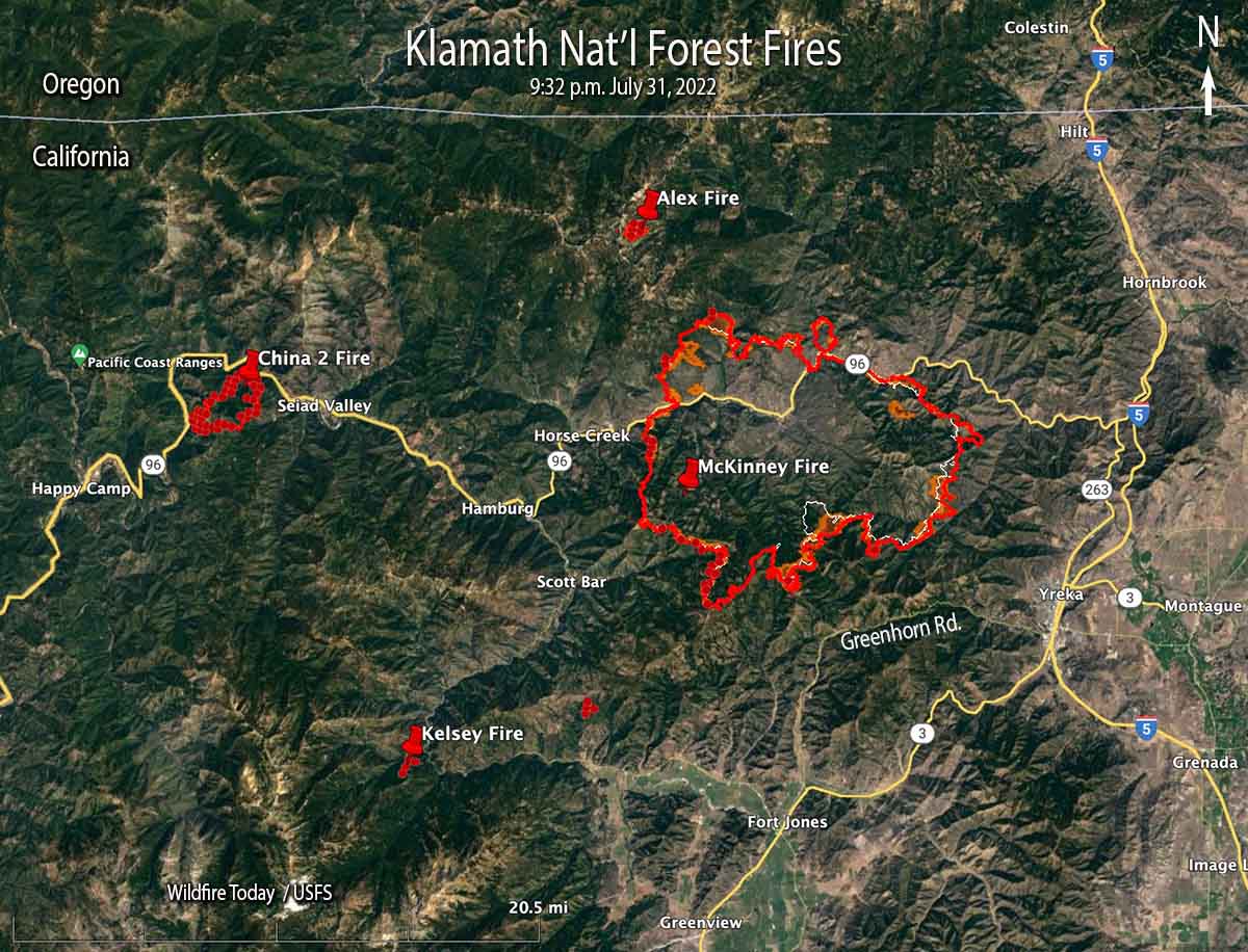
McKinney and other fires on or near the Klamath National Forest, 9:32 p.m. July 31, 2022.
The Siskiyou County Sheriff’s Office announced early Monday morning that at about 10 a.m. Sunday two individuals were found deceased in a burned vehicle in the path of the McKinney Fire in Northern California. The vehicle was in a residential driveway along Doggett Creek Road off Highway 96 west of the community of Klamath River, California.
To see all articles on Wildfire Today about the McKinney Fire, including the most recent, click HERE.
Rain on the west side of the fire very early Sunday morning and a heavy smoke inversion helped limit growth Sunday, but also kept aircraft mostly grounded. The weather station on Mt. Baldy on the western edge of the fire received just over half an inch, Scott Barr three miles west of the fire got 0.19″, and Oak Knoll off Highway 96 received 0.01″. Several locations near Yreka recorded no precipitation.
Map of the McKinney Fire at 9:32 p.m. PDT July 31, 2022. The brown areas represent intense heat.
The fire was mapped Sunday night at approximately 55,493 acres. It is being managed under Unified Command with the US Forest Service and the CAL FIRE.
Saturday night the McKinney Fire was:
5 miles from Yreka
6 miles from Interstate 5
9 miles from Fort Jones
4 miles from Scott Bar
2 miles from Horse Creek
The Siskiyou County Sheriff’s Office ordered evacuations of more than 2,000 people near Yreka. Details can be found on their Facebook page. A Zonehaven Aware map is also available.
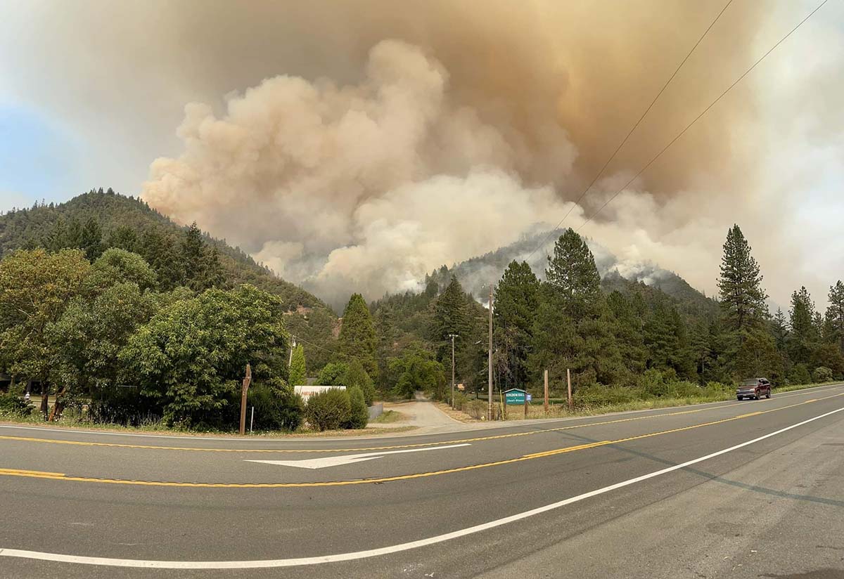
The Siskiyou County Sheriff’s Office has confirmed that several structures have been destroyed. Sheriff’s office Spokeswoman Courtney Kreider said residences along Highway 96 in the Klamath River drainage burned. She did not have a specific number. An online video shows that the Community Hall in Klamath River burned.
At least 10 fires, including the McKinney Fire, were burning in Siskiyou County as of late Sunday night, according to the Siskiyou County Office of Emergency Services.
Fire officials said the spread of the Alex Fire near Condrey Mountain four miles north of the McKinney Fire has been stopped. It was mapped at about 140 acres.
The China Fire west of Seiad has burned 1,989 acres south of Highway 96.
The Kelsey Fire was 10-15 acres Sunday afternoon and has evacuation orders in place. Numerous resources are on scene and more continue to arrive. It is west of Scott River Road nine air miles southwest of Scott Bar.
Highway 96 is closed and Interstate 5, which is six miles east of the fire, remains open.
Monday’s weather forecast calls for a 25 percent chance of showers and isolated thunderstorms with a high of 80 to 93 degrees with the humidity dropping into the 20s in the lower elevations. The wind will be out of the west at 4 to 7 mph with gusts to 14 mph.
The AlertWildfire camera in Northern California on Herd Peak recorded the effect of what is likely outflow winds from a thunderstorm affecting smoke from the McKenney Fire. At the time on Sunday afternoon July 31, 2022 it had burned about 52,000 acres northwest of Yreka. It appears that the fire is spreading across the ground, but most likely it is just smoke.
To see all articles on Wildfire Today about the McKinney Fire, including the most recent, click HERE.
Rain on the fire
It was very spotty, but some locations on the McKinney Fire received rain Saturday night between 10 p.m. and 3 a.m. Sunday morning. The weather station on Mt. Baldy on the western edge of the fire received just over half an inch, Scott Barr three miles west of the fire got 0.19″, and Oak Knoll off Highway 96 received 0.01″. Several locations near Yreka recorded no precipitation.
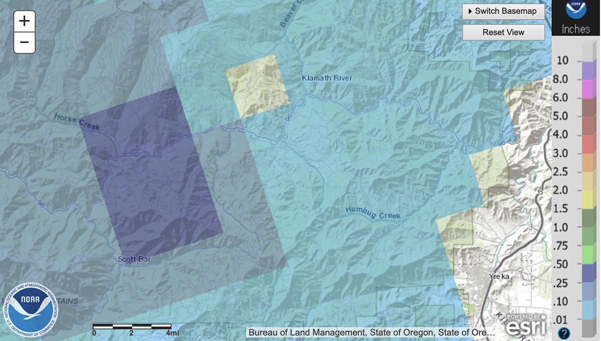
There are very few weather stations in or near the fire area, but the National Weather Service produced the map below with estimated precipitation amounts based on radar observations.
Radar observed precip, for the 24-hour period ending at 5 a.m. PDT July 31, 2022. NWS.
The west side of the fire received the most precipitation, according to the radar, with much less on the east side. The radar data is just an estimate, but it appears possible that a good sized portion of the west side received at least a wetting rain, with much of that side experiencing between 0.10 and 0.50″. If this is the case, the east side should see more fire growth for at least the next day or so than on the west side.
Fire activity
The rain combined with an inversion Saturday evening to slow the fire, but activity increased in some locations around midnight. Crews were actively engaged in structure protection in the Klamath River area. Little progression was observed on the southeast side closest to Yreka.
The McKinney Fire was mapped Sunday afternoon at 52,499 acres. The China 2 Fire 15 miles west of the McKinney Fire has burned 1,652 acres on the south side of Highway 96.
Sunday
Priorities for Sunday are to continue structure preparation and protection in the Highway 96 corridor, and around the communities of Fort Jones and Yreka.
Homes destroyed
The Siskiyou County Sheriff’s Office has confirmed that several structures have been destroyed. Sheriff’s office Spokeswoman Courtney Kreider said residences along Highway 96 in the Klamath River drainage burned. She did not have a specific number.
Updated at 5:36 a.m. PDT July 31, 2022
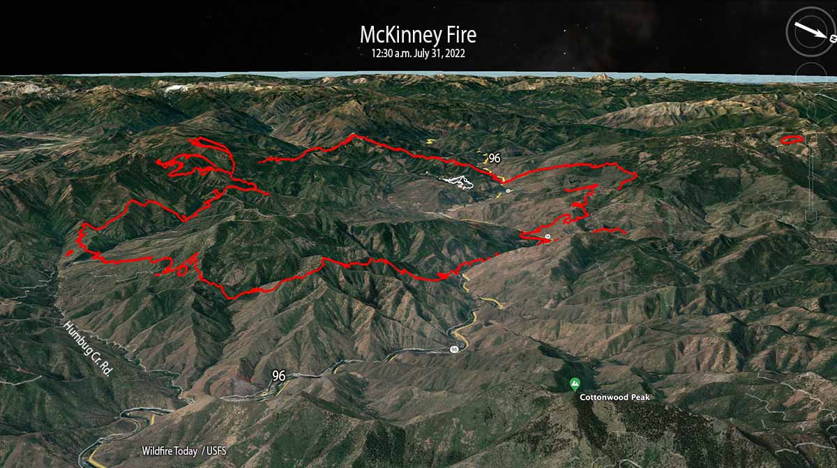
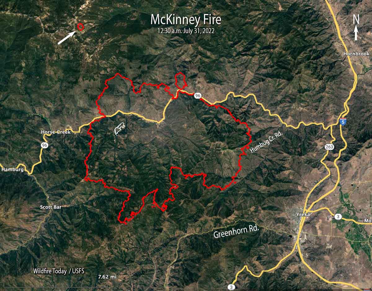
McKinney Fire 3-D map, looking west-southwest at 12:30 a.m. PDT July 31, 2022. The white lines were the perimeter at 5:19 p.m. on July 29.
The McKinney Fire in Northern California eight miles south of the Oregon state line was very active throughout the night. When it was mapped by an aircraft at 12:30 a.m. Sunday it had grown to 51,468 acres. During a satellite overflight at 3:38 a.m. about 90 percent of the heat detected was on the east and southeast sides.
This was the only complete mapping of the fire since noon on Saturday due to thunderstorms and lightning in the area which restricted flights of air tankers and helicopters.
McKinney Fire map at 12:30 a.m. PDT July 31, 2022. The white line was the perimeter at 5:19 p.m. on July 29.
At 12:30 a.m. Sunday it was 5 miles northwest of Yreka, 2 miles north of Greenhorn Road, 5 miles west of Highway 263, 4 miles east of Scott Bar, and 2 miles east of Horse Creek.
The mapping flight found a 75-acre fire burning four miles northwest of the McKinney Fire east of Condrey Mountain. It is unknown at this point if it a new fire or a spot from the McKinney.
Another fire 15 miles west of the McKinney Fire, the China 2 Fire, has burned approximately 1,000 acres south of Highway 96 in the Seiad Valley area.
Weather
Isolated and scattered thunderstorms with little or no rain are predicted for the area on Sunday with gusty outflow winds of 40-50 mph and cloud to ground lightning. Pyrocumulus could regenerate with potential for rapid fire growth and spread. There is a 5 percent chance of wetting rain. The relative humidity will be 15 to 25 percent.
Updated 6:41 p.m. PDT July 30, 2022
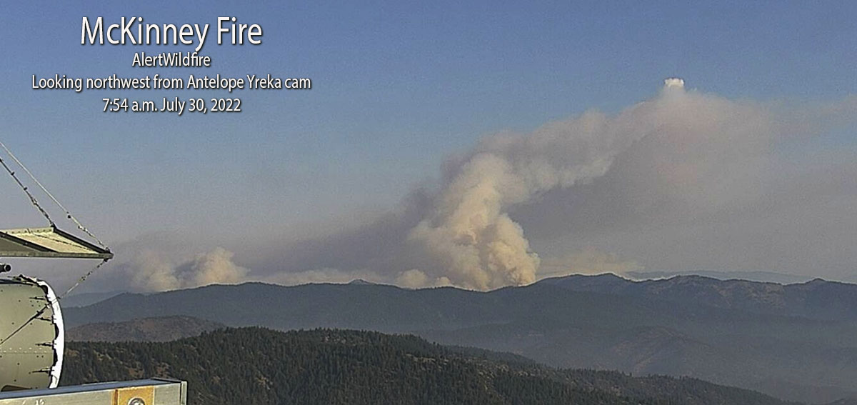
Saturday afternoon the area around the McKenny Fire northwest of Yreka, California was covered by cumulonimbus clouds, thunderstorms with lightning. This made it very difficult for air tankers, helicopters, or mapping aircraft to work over the blaze. Even the AlertWildfire cameras on mountain peaks late in the afternoon could see nothing but smoke. But satellite imagery peeking through breaks in the clouds detected intense heat from the fires.
The video below shows lightning and heat detected by a satellite during a 2-hour period ending at 6:21 p.m. PDT July 30 in Northern California and southwest Oregon. The red areas represent heat from the fires. The white line is the Oregon/California border. The white flashes are lightning.
Evacuations are in effect over a large area, ordered by the Siskiyou County Sheriff. Details can be found on their Facebook page. A Zonehaven Aware map is also available.
At 3 p.m. Saturday the US Forest Service estimated the fire had burned 30,000 to 40,000 acres.
Updated 1:20 p.m. PDT July 30, 2022
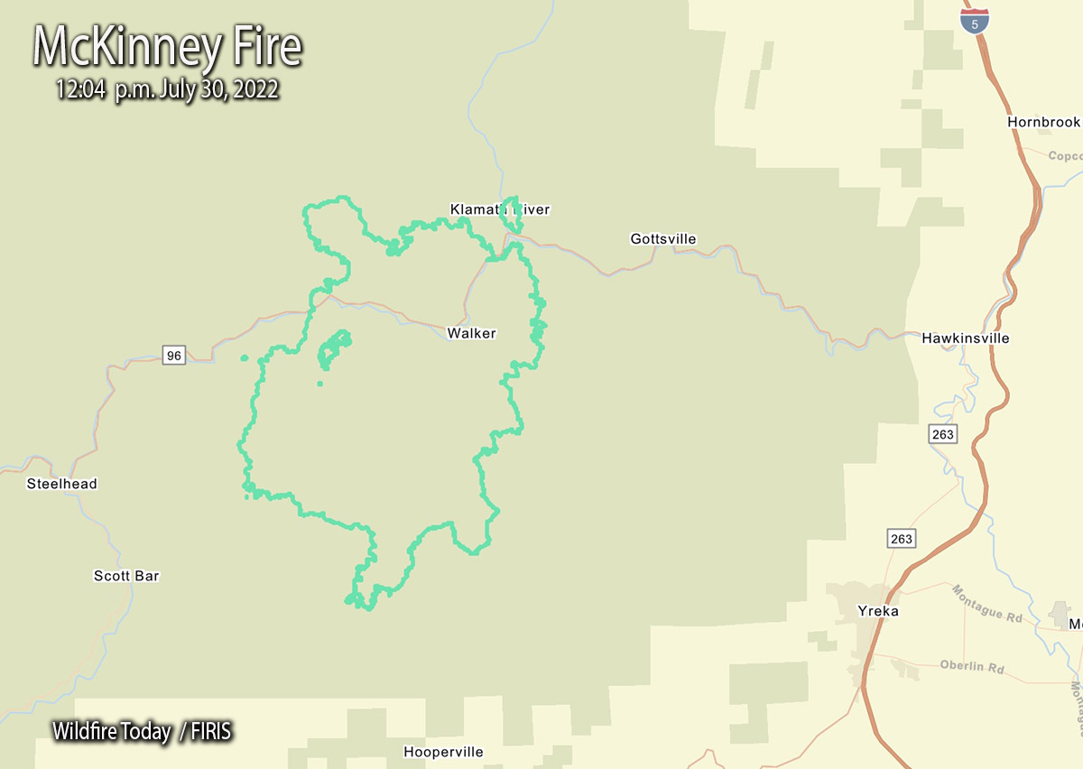
McKinney Fire map, 12:04 p.m July 30, 2022
The FIRIS aircraft mapped the McKinney Fire at an astounding 29,493 acres just after noon today. That explosive growth is less than 24 hours after it was reported at 2:15 p.m. Friday. (See map above)
This current map shows us that at 12:04 p.m. Saturday it was 9 miles west-northwest of Yreka, 3 miles northwest of Scott Bar, and 3 miles west of Gottsville.
During its first 22 hours it spread north 4 miles, east 5 miles, south 6 miles, and west about 2 miles.
9:48 a.m. PDT July 30, 2022
The McKinney Fire northwest of Yreka, California grew rapidly after it was reported Friday afternoon south of Highway 96 in the Klamath National Forest. Since then it has spread north across the highway and also to the south. At about 5 a.m. Saturday the Siskiyou County Sheriff said it was approximately four miles from Scott Bar after having been very active all night.
At about 8:45 a.m. on Saturday the Klamath National Forest estimated it had burned approximately 18,000 acres. The most recent perimeter map available is from Friday at 5:19 p.m., when it was only 65 acres. This current estimate from the Forest Service indicates it is 277 times larger. Additional perimeter mapping data was most likely prevented by lightning and thunderstorms in the area.
The fire was 14 miles northwest of Yreka when first reported, but grew closer overnight.
Evacuations are in effect over a large area, ordered by the Siskiyou County Sheriff. Details can be found on their Facebook page. A Zonehaven Aware map is also available.