A television station in Sacramento, ABC10, has recently produced several videos 8 to 13 minutes long about the wildfires in California. We will be showing you a few of them over the next couple of days.
The example below is about the Eldorado Hotshots, and features a former military sniper and another who initially received his fire training as a member of an inmate crew.
The blaze in Northern California is nearly contained
Aerial photo, off Herb Lane near Skyway in Paradise. From the Butte County drone mapping project.
Large quantities of rain that began Wednesday are helping firefighters contain the Camp Fire that devastated most of Paradise and the adjacent Concow community in Northern California. Rainfall in the last 72 hours in the county, Butte County, varied from 0.94″ to 7.10″.
To see all of the articles on Wildfire Today about the Camp Fire, including the most recent, click HERE.
CAL FIRE reports that the only uncontained section of the fire is in steep, rugged terrain that is unsafe for firefighters to access due to the heavy rains. There is indirect control line in that area and firefighters are monitoring the situation. Once safe to do so, crews will assess the situation and determine if direct line is necessary. The agency said the fire has burned 153,336 acres.
After the rain this week the Redding Searchlight quoted Stephen Horner, a public information officer for the Camp Fire, as saying, “The fire is out”. Large wildfires, especially megafires like this one, are not usually declared officially “out” until there is nothing burning anywhere within the perimeter. In spite of rain and snow, trees, roots, and logs can continue burning for months; some may overwinter and continue to burn into the following Spring.
The number of fatalities has risen to 84 with 475 reported as unaccounted for. Almost 14,000 homes have been destroyed.
This week some residents of Magalia were allowed to return to their homes, but other areas, especially in Paradise, are still under evacuation orders.
The rain has made it much more difficult to search through the ashes to find and recover bodies.
One of the primary tasks still facing firefighters is the removal of hazardous trees that are still standing but are dead or partially burned and likely to fall.
Agencies in Butte County have worked with cooperators to acquire aerial photography of the populated areas that were the most severely affected by the Camp Fire. On 500 drone flights they took 70,000 photos that have been georeferenced and formatted into a map. The still photos, videos, and 360-degree images can help residents check the status of their homes. It was a massive undertaking that was completed in just a couple of days by 16 drone teams and several organizations that used the data to produce the map and videos.
Near Orchard Drive in Paradise. From the Butte County drone mapping project.
The photos and videos can help residents check the status of their homes
Photo taken by a drone in Paradise near Kilcrease Circle.
A large group of mapping and drone experts have photographed from the air the Paradise, California area that was devastated by the Camp Fire that roared through the communities November 8. The photos and videos shot by drones were all georeferenced and put into a map format, making it possible for residents to check the status of their homes. Drones flew above all of the major roads shooting videos, and 360-degree photos were taken from the air in 200 locations which can be panned and zoomed. The resolution is very good since they were taken with 20 megapixel cameras.
Photo taken by a drone in Magalia near Indian Drive.
The maps can be viewed at the Butte County website. The site is a little glitchy and I found that it did not work well with the Chrome browser; the street names, videos, and 360-degree photos were not available. It worked fairly well with the Firefox browser, but a window on the left side could not be eliminated which obscured about half the map. I did not try it with Internet Explorer. In spite of these issues, what the group accomplished in about two days is an incredible achievement, and may be the first time the process has been used on this scale to provide such detailed information to a population suffering from a natural disaster.
To see all of the articles on Wildfire Today about the Camp Fire, including the most recent, click HERE.
The 16 teams of drone operators conducted 500 flights in two days to collect 70,000 photos over 17,000 acres.
In addition to this resource, officials are mapping one by one the structures affected by the fire. That map is also available to residents who want to check on the status of their homes.
The video below explains the technical details of how the imagery was collected and displayed.
Robert DePalma, 59, left, and William Erlbacher, 39, right, of Concow, CA. CAL FIRE photo.
CAL FIRE reported that two suspects have been arrested for the burglary and looting of a CAL FIRE station during the Camp Fire on November 8.
Robert DePalma and William Erlbacher, both of Concow, California, were arrested on five felony counts including vehicle theft, looting during an emergency, and possession of stolen property.
Their bail is set at $250,000 each.
The fire has killed at least 81 people and destroyed over 13,700 residences in Paradise and other nearby communities in California. About 870 people are still unaccounted for.
Our Opinion:
Looting an evacuated area that has been devastated by a natural disaster is one of the most disgusting, abhorrent, and sleazy crimes there is. But doing it at a facility where public employees are out helping citizens and putting their lives on the line takes it to a repugnant new level. If DePalma and Erlbacher are found guilty they deserve the the most severe sentence allowed under the law.
Today I was reading an article about how the communities in Northern California are dealing with the risk from wildfire. One item that got my attention was where a “forestry and wildfire specialist” was quoted describing the Fountaingrove area of Santa Rosa which was devastated by the Tubbs Fire in October of last year.
…a housing development in a rural area that had been built following the highest fire safety standards. Vegetation had been cleared as required, and the homes were built of fire-resistant materials.
The article correctly stated that the development had been “reduced to ashes by the Tubbs Fire”.
“How could that have happened?”, I thought. Fire resistant building standards and cleared vegetation? Firefighters know that if those two characteristics can be checked off, a structure has a much better chance of survival. So how did the community get wiped out?
The Fountaingrove community is 4 miles north of the intersection of Highways 101 and 12 in Santa Rosa. The Tubbs Fire, the deadliest of the fires in 2017, burned into the north section of Santa Rosa, including the Fountaingrove area. It killed 22 people, destroyed 5,643 structures, and burned 36,807 acres.
Map showing the perimeters of the Pocket, Tubbs, Nuns, and Atlas Fires. CAL FIRE October 15, 2017.
I would not call Fountaingrove a “rural area”. The thousands of homes there are very tightly packed, as you can see in the satellite photo below taken about five months before the Tubbs Fire.
Satellite photo of an area in Fountaingrove May 17, 2017, before the Tubbs Fire. Google Earth.
The next three photos are all of the same area, showing structures on Fir Ridge Road before and after the Tubbs Fire of October, 2017.
Fir Ridge Road area of Fountaingrove before the Tubbs Fire. Google Maps.Satellite photo of the Fir Ridge Road area in Fountaingrove, June 16, 2017. Google Earth.Satellite photo of the Fir Ridge Road area in Fountaingrove, October 17, 2017. Google Earth.
The photo below was taken before the fire, a few blocks south of the ones above. This home and all others around it burned.
A home on South Ridge Road in Fountaingrove before the Tubbs Fire. Google Maps.
The Fountaingrove area burned in the 1964 Hanley fire. During the 53-year period until the next fire, the 2017 Tubbs Fire, the houses grew back along with a great deal of vegetation. Most of the homes have shrubs in the yards and multiple large trees, often between the houses that are very close together. Some of the structures are partially obscured from aerial photos by limbs hanging over the roofs.
It is difficult to tell if the homes in these photos were constructed of fire resistant materials. But it is clear that other Firewise principles were not being followed.
In a fireprone environment there should be no flammable material within 5 feet of a structure, and in the Home Ignition Zones 5 to 100 feet away, trees need to be 6 to 18 feet apart depending on the distance from the building. If on a slope, these distances have to be increased substantially.
An excellent video that elaborates on these principles has been produced by the NFPA. It points out that the areas in between the trees do not have to be nuked. But to be fire resistant they need to consist of green grass or fire resistant small plants, and should be raked or mowed close to the ground.
If a structure meets these Firewise guidelines, it stands a much better chance of surviving a wildfire. However, if the weather conditions are extreme, such as 60 mph winds and single digit humidity which can lead to spot fires igniting a mile ahead of the main fire, it can be difficult to save a structure.
Most homes are ignited not by the main flaming front of a fire, but from burning embers that land out ahead and start new fires. Likely receptors for these embers are leaves in a gutter, mulch, wooden decks, lawn furniture, attic vents, and accumulations of dead grass, pine needles, leaves, and other flammable material.
When a community is initially planned, the engineers may have done some things right, such as the design of the streets, and water systems. But if everything else is left up to the knowledge and discretion of developer and homeowner, very important principles might be ignored.
Fountaingrove did not meet all of the Firewise guidelines, but the streets were wide, making it easier for large fire trucks to access the structures. The very close spacing of the homes means that if one burns, the radiant heat alone can ignite its neighbor.
Other things to consider in mitigating the wildfire threat include multiple evacuation routes — if one becomes compromised by the fire, another could remain open. Large open spaces without flammable vegetation can serve as safety zones for residents who can’t escape. Backup electrical power sources that can keep pumps running so that community water tanks remain full can ensure firefighters have water at hydrants.
With the warming climate leading to extreme fires and fire seasons that are nearly year round, it is inevitable that deadly fires will strike many wildland-urban interface communities. Under the conditions we have seen in recent years, casually ignoring the threat will lead to more fatalities and property damage. It is not IF a fire will hit a fire prone area, but WHEN. The best solution is to learn to live with and adapt to fire, not ignore it.
Many factors can lead to an area being vulnerable to wildfire, including fire suppression leading to a buildup of vegetation, density of homes like at Fountaingrove, failure of homeowners to use Firewise principles, lack of community standards, insurance companies not understanding the issue, the federal government reducing expenditures for vegetation management and prescribed burning, lawsuits that halt vegetation management projects, and cutting the numbers of firefighters, air tankers, and Type 1 helicopters. When politicians take hold of just one of these issues while ignoring the rest, it can make it impossible to have a rational conversation about adapting to fire.
Discussions need to be thorough and nuanced, not politicized and influenced by industry that profits from using just a single, ill-conceived concept. And zeroing in on one vague term like “raking” and “poor forest management” simply confuse the general public when the complete picture is not illuminated.
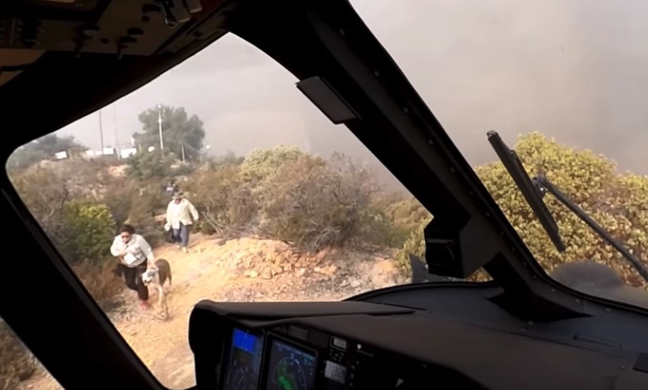
Three people and two dogs were were evacuated as the fire approached
Screenshot from the LA Fire Department video below. Three people and two dogs were rescued as the Woolsey Fire approached.
(Originally published at Fire Aviation)
While on a water dropping mission on November 9, the second day of the Woolsey Fire in Southern California, a Los Angeles Fire Department helicopter received a new assignment. Civilians were trapped on a mountain top as the fire approached. Even as they were running critically low on fuel the pilots found a way to land on a ridge top that was littered with communication towers and vehicles.
The video below was shot from a pilot’s helmet camera.
It was great work, team work, by the pilots to successfully pull this off. We appreciate that he filmed what they were doing, and that their department approved and helped to publicize the fact that the recording exists. Some public agencies have draconian rules about their employees or the public taking photos or recording video of their activities. Videos like this can help citizens understand what fire departments do and how they are carrying out their missions even as politicians may lob uninformed verbal assaults their way.
CAL FIRE says the Woolsey Fire has burned 96,949 acres and 1,500 structures, with no breakdown of residences vs. outbuildings. The number of civilian fatalities has remained at three for several days.