New satellites can aid in management of wildfires

Imagery from GOES 16 showed dramatic smoke plumes from the Camp Fire

Screenshot from the GOES 16 time-lapse of the Camp Fire.

The NASA article below lays out how the agency believes the imagery from recently launched satellites can assist in the detection and management of wildfires.


GOES-16, operating as NOAA’s GOES East satellite, is proving to be an invaluable asset in detecting wildfires and helping forecasters provide proactive tactical decision-support services. The satellite’s main instrument, the Advanced Baseline Imager (ABI), offers three times more spectral channels, four times increased resolution, and five times faster coverage than the previous GOES imager. This means a much more detailed look at fire conditions, faster detection of hot spots, and the ability to track fire progression and spread in real time.

National Weather Service (NWS) incident meteorologists (IMETs) are using GOES-16 data to assist firefighting efforts. IMETs who deploy to wildfires are instrumental to the mission. An IMET’s first priority is to keep firefighters and the public safe amid rapidly changing wildfire conditions. During the peak of the Camp Fire in northern California in November 2018, the fire was advancing at a rate of over 100 football fields every minute. A shift in the winds could easily put firefighters in danger.

GOES East captured imagery of the Camp Fire in northern California on November 8, 2018. The wildfire developed in the early morning hours and spread quickly within very windy and dry weather conditions. Hot spots and a large plume of smoke are seen in this fire temperature RGB (red-green-blue) imagery is created with Advanced Baseline Imager bands 7, 6, and 5 (shortwave and near infrared bands), which are used to detect hot spots. To make this animation, the fire temperature imagery is made partially transparent and placed over a GeoColor enhancement, so both the fire’s hot spots and smoke plume are visible.

Timely satellite imagery is critical, life-saving information in a dynamic fire environment. In the past, IMETs had a single low-resolution image that updated every 15 minutes – typically the image was already 20 minutes old when it arrived to the forecaster. Now, GOES-16 frequently detects fires before they are spotted on the ground – often 10 to 15 minutes before emergency notifications to 911.

Alex Hoon, the NWS IMET for both the Camp and Carr Fires in California in 2018, says GOES-16 is crucial to an IMET’s mission to protect lives and property. “Now, forecasters are able to get incredible high-resolution images of the fire every single minute in the field, directly supporting firefighters who are engaged in the fire. Not only is this helping firefighters to more effectively fight fire, but more importantly, it’s helping to keep firefighters safe so that they can also come home to their families,” said Hoon.

GOES-16 is also used to pinpoint the exact location of a fire after reports of smoke. On July 2, 2018, the Pueblo County, Colorado, Emergency Management Office called the NWS Pueblo Weather Forecast Office (WFO) for assistance locating the source of smoke reported near Custer/Fremont/Pueblo County lines. GOES-16 showed a hotspot in northeast Custer County and the Pueblo WFO was able to provide the exact coordinates of what would become the Adobe Fire. Being in a remote and wooded area, the early and more precise geolocation of the fire was helpful for getting crews on the scene quickly.

GOES-16 observations are not just valuable for detecting wildfires but are also critical to observing and monitoring smoke from those fires. GOES-16’s ability to monitor smoke plumes in near-real time is particularly useful in directing firefighting efforts from the air. Deploying airplanes and helicopters to spray fire retardant is often hampered due to poor visibility. GOES-16 can help guide decisions for deploying flights by providing information on the exact location and motion of smoke from a fire. The smoke detection and monitoring information also enable better air quality forecasts.

The benefits from GOES-16 aren’t just seen during a fire but are also important in monitoring burn scars and predicting flash flood events from rain events after a fire. GOES-16 provides critical data for the entire lifecycle of a fire disaster – from drought to fire to floods and landslides.

The new capabilities from GOES-16 are a game-changer for fire weather forecasts and warnings. Soon, GOES-16 will be joined by its twin satellite, GOES-17, as NOAA’s operational GOES West. GOES-17 will provide even better resolution for U.S. West Coast firefighting efforts than GOES-16 due to its location over the Pacific Ocean.

New channels on the ABI provide more information to forecasters and the high resolution and rapid scanning give them high-definition images as often as every minute. Data from the ABI is helping forecasters locate hotspots, detect changes in a fire’s behavior, predict a fire’s motion, and monitor the post-fire landscape like never before. Providing this information to firefighters, emergency managers, and state and county agencies helps NOAA’s Satellite and Information Service meet its mission of protecting the nation’s environment, security, economy and quality of life.

A documentary about the Camp Fire at Paradise, California

There will probably be numerous documentaries released about the Camp Fire that erased much of Paradise, California as it killed at least 86 people and destroyed over 14,000 homes. Below is one of the first.

The fire will be an important part of California history, but it remains to be seen if it will be eclipsed in the next few years by even more unimaginable and disastrous fires as the climate becomes warmer and more prone to extreme events.

The film below, produced by Paradise-area film maker Golden Eagle Films, contains many interviews with residents that survived the inferno.


Thanks and a tip of the hat go out to Dave. Typos or errors, report them HERE.

Why did a 99-year old power line fail, igniting the Camp fire?

Investigators have removed parts of a transmission tower to examine more closely

Investigators are zeroing in on their goal to determine exactly what caused molten aluminum and metal to drop from a 115,000-volt PG&E power line tower at about 6:15 a.m. on November 8 near Poe Dam seven miles east of Paradise, California. A few hours later most of the town had been reduced to ashes as 50 mph winds pushed the wildfire through the community, killing at least 85 people and making thousands homeless.

As reported by an article in the Mercury News, something failed on the tower, causing a power line to get loose and whip around, striking metal which instantly heated, melted, and dropped to the ground igniting the vegetation. It could have been “a tiny O-ring that holds up rows of disc-shaped insulators, or possibly fatigued steel from one of the tower’s arms”, the article explains. The tower was built in 1919 which raises the possibility of worn out parts and metal fatigue. CAL FIRE has removed some pieces from the tower to examine further.

The newspaper also reports that CAL FIRE is investigating a possible second point of ignition below a PG&E lower voltage distribution line that occurred about half an hour after the first failure.

The Camp Fire started 13 months after the disastrous fires that burned in the Napa Valley in October of 2017. There are reports that at least 12 of them were caused by Pacific Gas & Electric power lines.

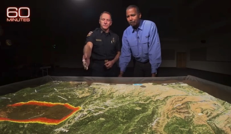
On 60 Minutes Chief Pimlott describes the rapid rate of spread of the Camp Fire

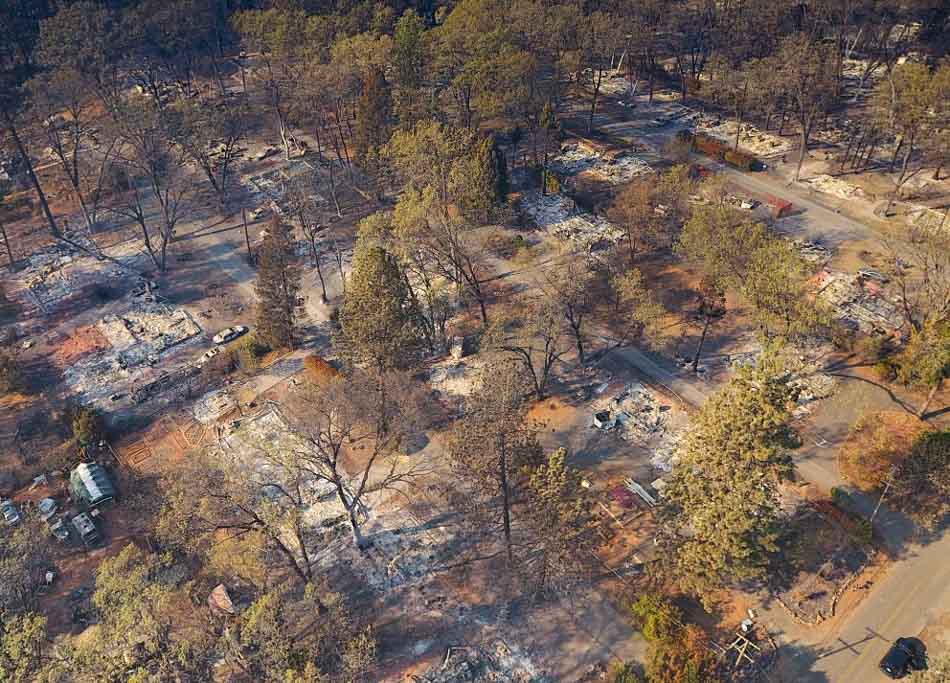
Camp Fire at Paradise California
Chief of CAL FIRE Ken Pimlott explains on 60 Minutes how the rapid rate of spread of the Camp Fire at Paradise, California. Screenshot from 60 Minutes video.

This is a 1 minute clip from a piece on Sunday’s edition of 60 Minutes in which Ken Pimlott, Chief of CAL FIRE, describes how the Camp Fire was growing during its first burning period at “one football field per second”. I assume he means it was consuming 1.3 acres per second which is the size of an American football field, rather than the rate of spread of the flaming front. The video shows one of those cool sand tables onto which a computer projects a spreading wildfire. They are excellent for training exercises and modeling fire behavior.

This clip was taken from a very good 10 to 15 minute piece on Sunday’s 60 Minutes about the Camp Fire, and is worth checking out. You can see the entire 42-minute show on the CBS website including the section on the fire, but you’ll have to watch the commercials.

List of unaccounted for in Camp Fire reduced to 11

Businessman gives $1,000 to each student at Paradise High School

Camp Fire Paradise area
Camp Fire, Paradise area. Butte County photo.

After reaching a high of more than 1,300 people, the number that are unaccounted for in the Camp Fire near Paradise, California has shrunk to just 11. Below are the last names, first names, age and  location if known:

  1. Baker, Harriett, Oroville
  2. Banks, Darla
  3. Casilla, John, 50-60, Paradise
  4. Cody, Florence, Paradise
  5. Demianew, John, 54, Paradise
  6. Fabila-Martinez, Sara, 50, Paradise
  7. Krug, Wendy, 46, Paradise
  8. Ruel, Devon, Chico
  9. Saubaysa (Sabalsa), Noe (Alejandro), 23
  10. Sparks, Johnm, Paradise
  11. Tafoya, Noelle

The Sheriff’s Office asks those who are listed and are safe to call the missing persons call center at 530-538-6570, 530-538-7544 or 530-538-7671.

The number of fatalities has been reduced to 85 after, according to the sheriff’s office,“remains originally thought to be separate cases have since been proved by DNA to be the same case.”

To see all of the articles on Wildfire Today about the Camp Fire, including the most recent, click HERE.

Of the 85 dead, three remain unidentified. Of those identified, 43 have been “positively identified,” with the rest still tentative, sometimes based on circumstantial evidence.

A San Diego businessman has given $1,000 checks to students and staff at Paradise High School.

Robert S. Wilson
Robert S. Wilson

From NPR:

“A San Diego businessman wanted to do something to help young people affected by the Camp Fire, which decimated the city of Paradise, Calif., earlier this month.

“So Bob Wilson came with two suitcases full of $1,000 checks – enough for each of Paradise High School’s 980 students and 105 staff members, including teachers, janitors and bus drivers.

“On a rainy Tuesday night, the students and staff from a town now dispersed showed up at nearby Chico High School, where Wilson handed out the checks — $1.1 million in all, according to The Associated Press.

“Wilson, 90, made his money in commercial real estate and shopping centers, and he’s also a partner in operating six Fish Market restaurants in California.”

Man sentenced to 5 years for burglarizing fire department truck during Carr Fire

Brian Martinson
Brian Martinson, Chico Police Department

A man who stole items from inside a Redding Fire Department truck during the Carr Fire at Redding, California received much more than the 1-year sentence plus probation recommenced by the Probation Department. Judge Cara Beatty gave Brian Daniel Martinson five years in county jail, according to the Shasta County District Attorney’s Facebook page.

Mr. Martinson had pleaded guilty to grand theft and committing the crime during a natural disaster.

Below is an excerpt from an article in the Redding Searchlight:

Martinson was accused of stealing items belonging to Redding firefighter Erick Mattson that were inside a fire department utility truck while it was parked in front of Mattson’s home.

Mattson was at his Palo Cedro home resting in between fighting the Carr Fire when Martinson broke into the truck.

In August, Martinson was arrested in Chico after being caught shoplifting from a Sportsman’s Warehouse. Officers there found Martinson with a backpack belonging to the firefighter and items from the fire department.

The stolen property included more than $5,000 worth of things that included a laptop and a hard drive containing family photos. Chico police said at the time the hard drive wasn’t located.

Butte County investigators questioned Martinson and he admitted to burglarizing the fire truck, the DA’s office said.

The Carr Fire started July 23, 2018, killed eight people and burned over 229,000 acres and 1,604 structures.

In a different but similar incident, the two men who were arrested on the first day of the Camp Fire for stealing a vehicle and other items from a fire station at Jarbo Gap November 8 have pleaded not guilty to the crimes. Robert DePalma and William Erlbacher, both of Concow, California are scheduled to appear in court December 6 for a preliminary hearing. They remain in custody with bail set at $250,000 each. More information about this incident is at the Chico Enterprise-Record.

The Camp Fire burned more than 153,000 acres at Paradise California, killed approximately 85 people (as of November 25, 2018), and destroyed over 14,000 homes.