Rain stops the spread of the Camp Fire

The blaze in Northern California is nearly contained

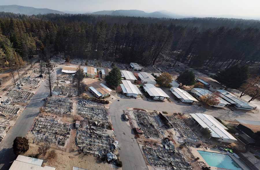
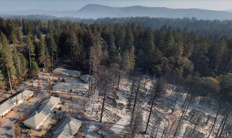
aerial photo Paradise Camp Fire
Aerial photo, off Herb Lane near Skyway in Paradise. From the Butte County drone mapping project.

Large quantities of rain that began Wednesday are helping firefighters contain the Camp Fire that devastated most of Paradise and the adjacent Concow community in Northern California. Rainfall in the last 72 hours in the county, Butte County, varied from 0.94″ to 7.10″.

To see all of the articles on Wildfire Today about the Camp Fire, including the most recent, click HERE.

CAL FIRE reports that the only uncontained section of the fire is in steep, rugged terrain that is unsafe for firefighters to access due to the heavy rains. There is indirect control line in that area and firefighters are monitoring the situation. Once safe to do so, crews will assess the situation and determine if direct line is necessary. The agency said the fire has burned 153,336 acres.

After the rain this week the Redding Searchlight quoted Stephen Horner, a public information officer for the Camp Fire, as saying, “The fire is out”. Large wildfires, especially megafires like this one, are not usually declared officially “out” until there is nothing burning anywhere within the perimeter. In spite of rain and snow, trees, roots, and logs can continue burning for months; some may overwinter and continue to burn into the following Spring.

The number of fatalities has risen to 84 with 475 reported as unaccounted for. Almost 14,000 homes have been destroyed.

This week some residents of Magalia were allowed to return to their homes, but other areas, especially in Paradise, are still under evacuation orders.

The rain has made it much more difficult to search through the ashes to find and recover bodies.

One of the primary tasks still facing firefighters is the removal of hazardous trees that are still standing but are dead or partially burned and likely to fall.

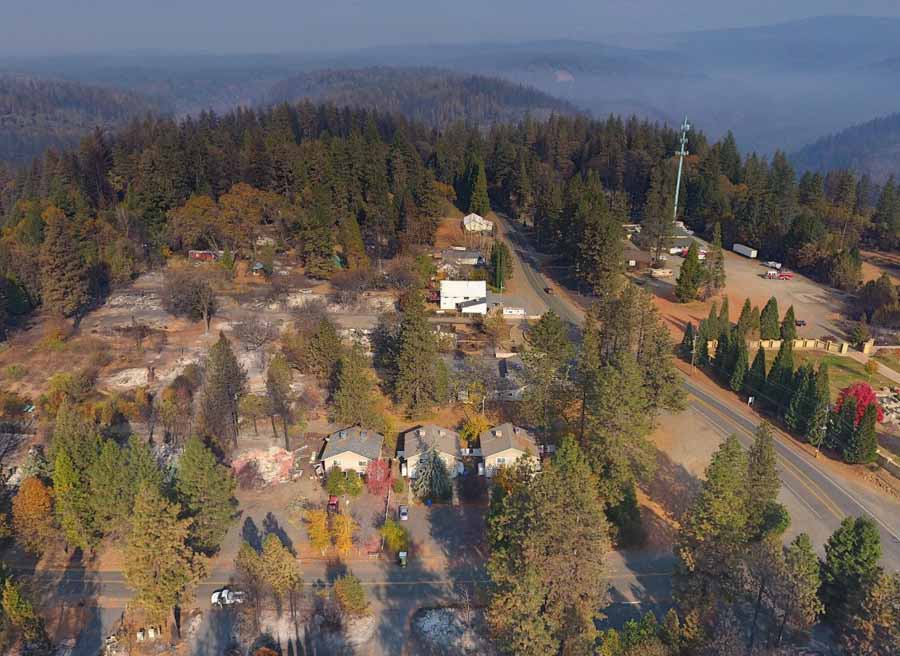
Agencies in Butte County have worked with cooperators to acquire aerial photography of the populated areas that were the most severely affected by the Camp Fire. On 500 drone flights they took 70,000 photos that have been georeferenced and formatted into a map. The still photos, videos, and 360-degree images can help residents check the status of their homes. It was a massive undertaking that was completed in just a couple of days by 16 drone teams and several organizations that used the data to produce the map and videos.
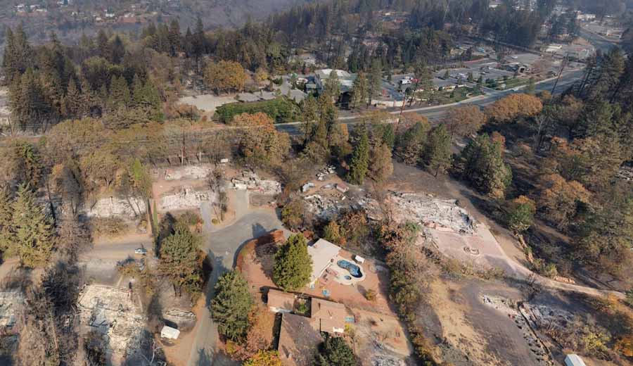
aerial photo Paradise Camp Fire
Near Orchard Drive in Paradise. From the Butte County drone mapping project.

Drones photograph the damage in Paradise caused by the Camp Fire

The photos and videos can help residents check the status of their homes

Camp Fire drone photo
Photo taken by a drone in Paradise near Kilcrease Circle.

A large group of mapping and drone experts have photographed from the air the Paradise, California area that was devastated by the Camp Fire that roared through the communities November 8. The photos and videos shot by drones were all georeferenced and put into a map format, making it possible for residents to check the status of their homes. Drones flew above all of the major roads shooting videos, and 360-degree photos were taken from the air in 200 locations which can be panned and zoomed. The resolution is very good since they were taken with 20 megapixel cameras.

Camp Fire drone photo
Photo taken by a drone in Magalia near Indian Drive.

The maps can be viewed at the Butte County website. The site is a little glitchy and I found that it did not work well with the Chrome browser; the street names, videos, and 360-degree photos were not available. It worked fairly well with the Firefox browser, but a window on the left side could not be eliminated which obscured about half the map. I did not try it with Internet Explorer. In spite of these issues, what the group accomplished in about two days is an incredible achievement, and may be the first time the process has been used on this scale to provide such detailed information to a population suffering from a natural disaster.

To see all of the articles on Wildfire Today about the Camp Fire, including the most recent, click HERE.

The 16 teams of drone operators conducted 500 flights in two days to collect 70,000 photos over 17,000 acres.

In addition to this resource, officials are mapping one by one the structures affected by the fire. That map is also available to residents who want to check on the status of their homes.

The video below explains the technical details of how the imagery was collected and displayed.

Two suspects arrested for looting fire station during Camp Fire

DePalma And Erlbacher
Robert DePalma, 59, left, and William Erlbacher, 39,  right, of Concow, CA. CAL FIRE photo.

CAL FIRE reported that two suspects have been arrested for the burglary and looting of a CAL FIRE station during the Camp Fire on November 8.

Robert DePalma and William Erlbacher, both of Concow, California, were arrested on five felony counts including vehicle theft, looting during an emergency, and possession of stolen property.

Their bail is set at $250,000 each.

The fire has killed at least 81 people and destroyed over 13,700 residences in Paradise and other nearby communities in California. About 870 people are still unaccounted for.


Our Opinion:

Looting an evacuated area that has been devastated by a natural disaster is one of the most disgusting, abhorrent, and sleazy crimes there is. But doing it at a facility where public employees are out helping citizens and putting their lives on the line takes it to a repugnant new level. If DePalma and Erlbacher are found guilty they deserve the the most severe sentence allowed under the law.

Secretary of Interior blames “environmental radicals” for California wildfires

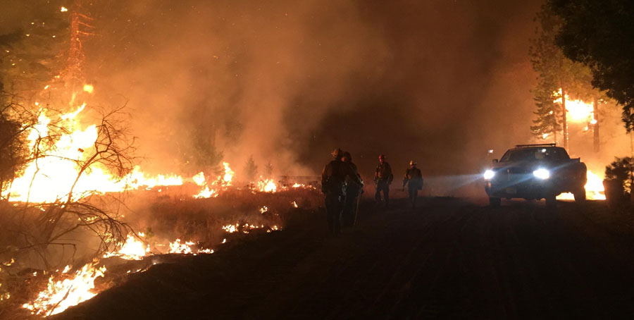
Camp Fire
A firing operation on the Camp Fire. Inciweb photo. Click to enlarge.

Ryan Zinke, like his boss President Trump, blamed something other than the extreme wind, low humidity, and drought for the two recent devastating wildfires in California that have killed 80 people.

Below is an excerpt from an article at The Hill:

Interior Secretary Ryan Zinke blamed “environmental radicals” for the California wildfires that have killed at least 77 people, saying they stop forest management practices that could have prevented the fires.

Days after touring the damage of the Camp fire, the deadliest in California’s history, Zinke went on Breitbart News Sunday and declared “it’s not the time for finger-pointing” on the causes of the fires.

But minutes later, he put the blame squarely on environmentalists, contending that they stood in the way of clearing brush, doing prescribed burns and other actions.

“I will lay this on the foot of those environmental radicals that have prevented us from managing the forests for years. And you know what? This is on them,” Zinke said.

While touring the Camp and Woolsey Fires Saturday Mr. Trump reiterated at every stop that he believes forest management in California was the key issue in preventing devastating fires, and threatened to cut fire funding for the state. He mentioned the “forest nation” of Finland as a good example that spends “a lot of time raking and cleaning….”

The fatality count on the Camp Fire east of Chico rose again Sunday as search teams found another set of human remains to bring the total loss of life to 77, with 993 unaccounted for. The current tally for the number of homes destroyed is 11,990, and acres burned, 151,000. The number of commercial structures burned rose from 367 to 472.

The remains of three individuals have been found in the Woolsey Fire at Malibu, California. That fire has burned 96,949 acres and 1,130 structures.

Smoke creates record high pollution levels in California cities

The Camp Fire continues to affect air quality

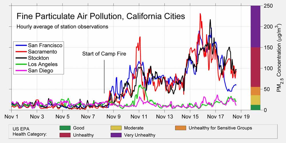
smoke pollution particulates record California cities
Records show a large increase in particulates in some California cities after the Camp and Woolsey Fires started on November 8, 2018. Via @RARohde. Click to enlarge.

Areas in Northern California have been suffering through unprecedented air pollution since the Camp Fire started November 8 east of Chico. Sacramento, San Francisco, and Stockton have all recorded record high levels.

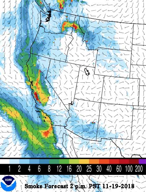
The animation below shows the predicted wind direction for Northern California at 9 a.m. PST November 19, 2018. If accurate, the wind could bring smoke from the Camp Fire, which is just east of Chico, down into the Sacramento Valley, the Bay Area, and the Central Valley on Monday. This condition should reverse Tuesday through Friday with the smoke being pushed to the north away from San Francisco, but Saturday could again bring wind and smoke from the north if the Camp Fire is still active.

On Sunday and Sunday night the Camp Fire was active on the east side and will likely produce a significant amount of smoke Monday. But Wednesday through Friday should bring copious amounts of rain to the fire area, perhaps more than two inches, which will definitely inhibit the production of smoke and slow the spread of the fire — at least.

The fatality count on the Camp Fire rose again Sunday as search teams found another set of human remains to bring the total loss of life to 77, with 993 unaccounted for. The current tally for the number of homes destroyed is 11,990, and acres burned, 151,000. The number of commercial structures burned rose from 367 to 472.

wildfire smoke forecast map
The forecast for the distribution of wildfire smoke at 2 p.m. PST November 19, 2018. NOAA.

President visits the devastating wildfire at Paradise, California

Mr. Trump traveled to a burned trailer park at the Camp Fire

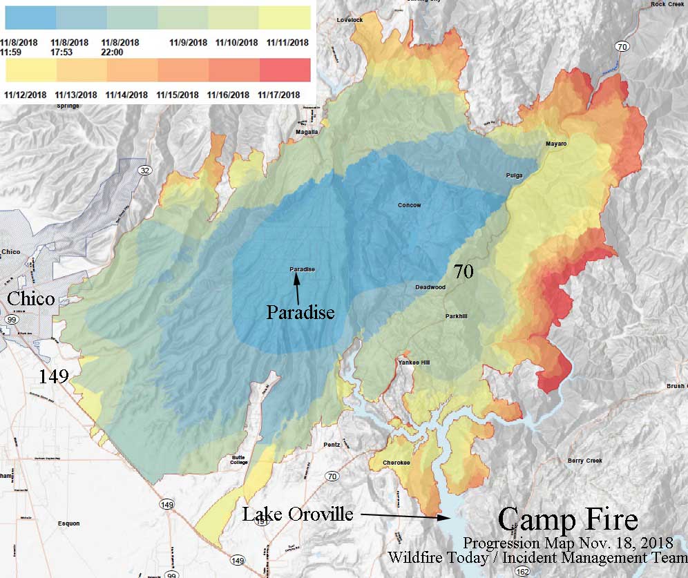
Progression map of the Camp Fire
Progression map of the Camp Fire, November 17, 2018. Base map produced by the Incident Management Team. Notations and insertion of legend by Wildfire Today. Click to enlarge. A full-size version of the map can be downloaded (large 3 MB file).

(UPDATED at 1:31 p.m. PST November 18, 2018)

Yesterday President Trump traveled to California to see first hand the destruction caused by the two recent very large fires in the state. Air Force One landed at Beale Air Force Base and then Mr. Trump helicoptered in Marine One about 40 miles north to the Incident Command Post for the Camp Fire at Chico where he met with Governor Jerry Brown and Governor-elect Gavin Newsom. He also had a very short briefing from the Incident Commander as they looked at the progression map (see the map above).

To see all articles on Wildfire Today about the Camp Fire, including the most recent, click HERE.

Saturday evening Butte County Sheriff Kory Honea announced that five more bodies were found, bringing the total number killed on the Camp Fire to 76. More than 1,200 are on the unaccounted for list, but officials warn that it most likely includes duplications and errors. According to CAL FIRE the fire has burned 149,000 acres, 9,891 residences, and 367 commercial structures.

The group toured a portion of the burned area in Paradise with the city’s Mayor Jody Jones, and made a stop at the Skyway Villa Mobile Home and RV Park.

President Trump Camp Fire visit
President Trump at the Skyway Villa Mobile Home & RV Park in Paradise, California, site of the Camp Fire. Screen shot from Global News video.

While at the Incident Command Post Mr. Trump promised to include $500 million in the Farm Bill in what he called “a new category, management and maintenance of forests”. At every stop Saturday he reiterated that forest management was a key issue in preventing devastating fires, including later in the day when visited the Woolsey Fire in Southern California. Firefighters and California residents are still reeling from the President’s November 10 tweet when he wrote:

There is no reason for these massive, deadly and costly forest fires in California except that forest management is so poor. Billions of dollars are given each year, with so many lives lost, all because of gross mismanagement of the forests. Remedy now, or no more Fed payments!

During his visit Mr. Trump mentioned the “forest nation” of Finland as a good example that spends “a lot of time raking and cleaning….”

When a reporter asked him if he had changed his mind about climate change after viewing the damage, he said:

No, no. I have a strong opinion. I want a great climate. I think we’re going to have that and I think we’re going to have forests that are really safe.

The video below was filmed while the President was at the Incident Command Post for the Camp Fire.

On Friday Butte County officials asked those who want to help the thousands of residents who lost all of their belongings, to not donate clothing or other items, but to send cash. The logistics of accepting clothes, including cleaning, storage, and redistribution, are very space and time consuming, especially in light of the rain that is in the forecast. “Shelter and drop-off locations are at capacity and cannot take any more items!” the county said on its Facebook page.

Below is a map of the Camp Fire, updated at 6:40 p.m. PST November 17, 2018, and then, photos of the mobile home park taken before the fire.
Continue reading “President visits the devastating wildfire at Paradise, California”