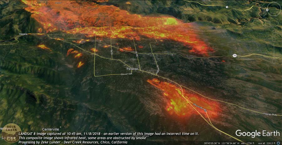
Satellite imagery of Camp Fire seven hours after it started

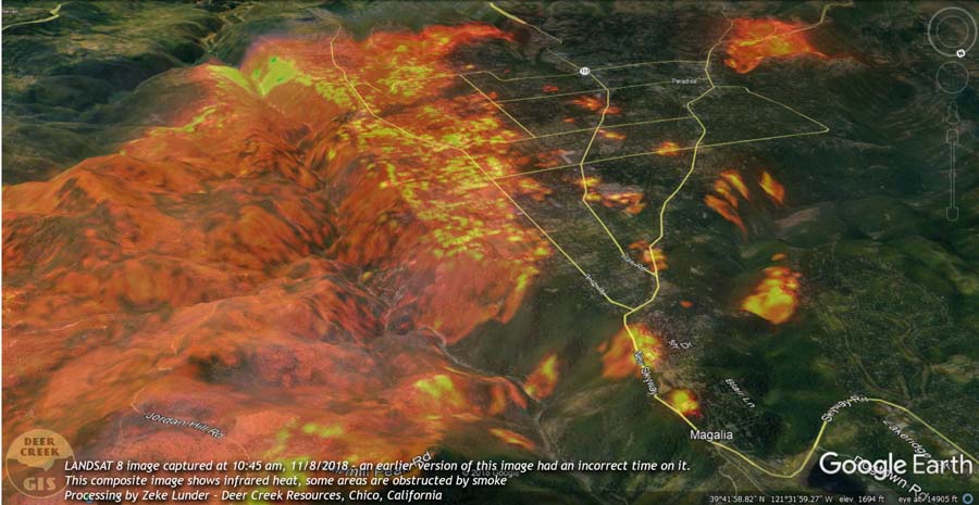
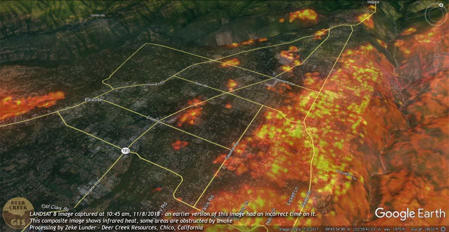
Deer Creek Resources of Chico, California has produced five images that show the Camp Fire about four and a half hours after it started near Pulga, California on November 8, 2018.  Zeke Lunder used data from LANDSAT 8 with the infrared heat layer to map the location of the fire at 10:45 p.m. PST. By that time it was burning thousands of homes in Paradise.

(The images below show the corrected time stamp of 10:45 a.m. on November 8, 2018.)

Camp Fire satellite photo 10:45 am Nov. 8, 2018. Zeke Lunder

Camp Fire satellite photo 10:45 am Nov. 8, 2018. Zeke Lunder

To help get oriented take note of the north indicator that is at the top-right on four of the four photos. Presumably north is at the top in the other photo (above).

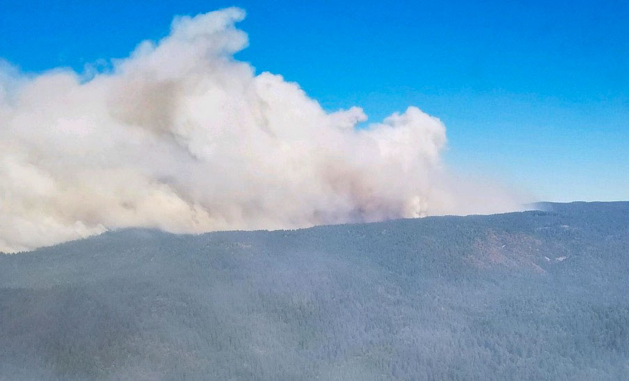
Camp Fire satellite photo 10:45 am Nov. 8, 2018. Zeke Lunder

Camp Fire satellite photo 10:45 am Nov. 8, 2018. Zeke Lunder

Camp Fire satellite photo 10:45 am Nov. 8, 2018. Zeke Lunder

To see all articles on Wildfire Today about the Camp Fire, including the most recent, click HERE.

Smoke obscures some areas, as Mr. Lunder wrote, but it appears that significant spotting was occurring. During that seven-hour period the wind was out of the northeast at 8 to 15 mph gusting at 21 to 35 mph. At noon the relative humidity was 13 percent. A few hours before the fire started the wind was from the northeast at 32 gusting up to 52.

Here is more information about the fuels that the fire was burning through in the first few hours.

CAL  FIRE has not released the cause of the fire but Pacific Gas & Electric disclosed to the Public Utilities Commission that one of their high voltage power lines had a disruption in service on Pulga Road near the Camp Fire at 6:15 a.m. the day it started, November 8. The burn pattern along with the wind direction would lead one to believe that it is likely that the point of origin of the fire was in the general vicinity of Pulga Road and the small community of Pulga, but this is not confirmed. The fire was reported at 6:29 a.m.

The Camp and Woolsey Fires have burned more than 10,000 structures

The death toll increased Thursday evening to a total of 66 for the two fires in California.

map destroyed homes structures camp fire paradise california
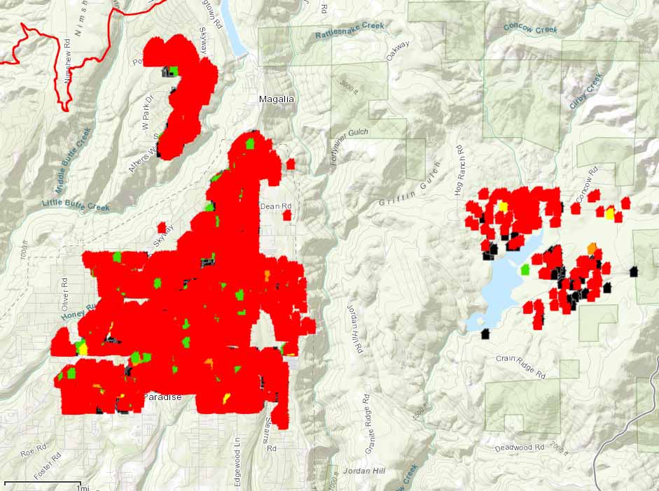
Red icons represent structures that are more than 50 percent burned in the Paradise and Magalia areas of the Camp Fire. The full zoomable map is HERE, where a person can search for individual addresses.

(UPDATED at 8:07 p.m. PST November 15, 2018)

Thursday evening fire authorities updated some of the information about the Camp Fire which has devastated areas around the town of Paradise, California. According to the Butte County Sheriff’s Office the number of fatalities has risen to 63, an increase of 7 over the last 24 hours. And surprisingly, the number that are unaccounted for changed from 130 to 631. Some of those could be in shelters, relocated to another part of the state, or without means of communication.

As of Thursday evening the fire has destroyed 9,700 single residences, 118 multi-residences, and 290 commercial structures, for a total of 10,108 buildings.

According to CAL FIRE, the Camp fire has burned 141,000 acres, an increase of exactly 1,000 acres in 24 hours.


(Originally published at 8:25 a.m. PST November 15, 2018)

A total of more than a quarter of a million acres have burned in the Woolsey and Camp Fires in California.

About 460 workers and 22 cadaver dogs are assessing the path that the Camp Fire took as it devastated the town of Paradise in Northern California on November 8. The estimated number of homes destroyed in the blaze is fluid and keeps rising, reaching 8,756 Thursday morning with another 260 commercial structures destroyed. The fatalities the crews have discovered has risen to 56, with 130 people still unaccounted for.

To see all articles on Wildfire Today about the Woolsey Fire, including the most recent, click HERE. For the Camp Fire, click HERE.

For the last several days the Camp Fire has continued to spread on the north and east sides, at a slower rate than earlier, but still adding thousands of acres each day. CAL FIRE is saying the fire has burned 140,000 acres.

ESRI and CAL FIRE, working with local emergency service providers, have established a mapping system that displays the status of structures affected by the Camp Fire. It is still a work in progress and is far from complete, as the workers survey the more than 10,000 homes in the Paradise and Magalia areas. Residents can view the map and search for addresses at the internet site.

Some of the refugees from the Camp Fire who have not been allowed into the burned area are living in temporary shelters and camping in parking lots of Walmart and other businesses.

In southern California, the Woolsey Fire has grown very little in the last couple of days, but unburned islands of vegetation occasionally ignite and put up substantial smoke columns. Officials estimate that 504 structures have been destroyed, but a survey that was 25 percent complete Wednesday evening found 370 that were confirmed to have burned. The numbers have not been broken out by residences, outbuildings, and commercial structures.

At about 12:20 Thursday morning a firefighter on the Woolsey Fire was struck by a passing civilian vehicle on the Pacific Coast Highway and was flown to Los Robles Regional Medical Center in Thousand Oaks. The injuries for the firefighter, who was from South Kitsap Fire and Rescue in Washington, were non-life threatening. Officials said it was not a hit and run incident.

On Wednesday fire officials raised the death total to three on the Woolsey Fire. CAL FIRE is saying the blaze has burned 98,362 acres.

Camp Fire continues to spread to the north and east

The number of fatalities within the fire area increases to 42

Camp Fire
Camp Fire. Photo credit: CAL FIRE.

The Camp Fire continues to march farther to the east and north as the dry, windy weather hangs on in California. Monday the blaze grew by about half a mile along most of the north and east perimeter. It was most active east of Highway 70, south of Stirling City, and on both sides of Lake Oroville.

(To see all articles on Wildfire Today about the Camp Fire, including the most recent, click here.)

CAL FIRE said Tuesday morning the fire has burned 125,000 acres.

The number of civilian fatalities within the fire area has increased by 13 on Monday to bring the total to 42. Butte County Sheriff Kory Honea has not said the number of deaths is likely to increase, but he has requested additional cadaver dogs, portable morgue units, and about 150 additional search and rescue personnel to assist in the search for human remains. About 200 people remain unaccounted for.

Fire officials estimate that the structures destroyed include 6,522 single residences, 85 multi-residences, and 260 commercial buildings.

CAL FIRE has released a map that shows the status of structures affected by the Camp Fire. The new map is still incomplete and is a work in progress.

firefighters fire trucks wildfire Camp Fire
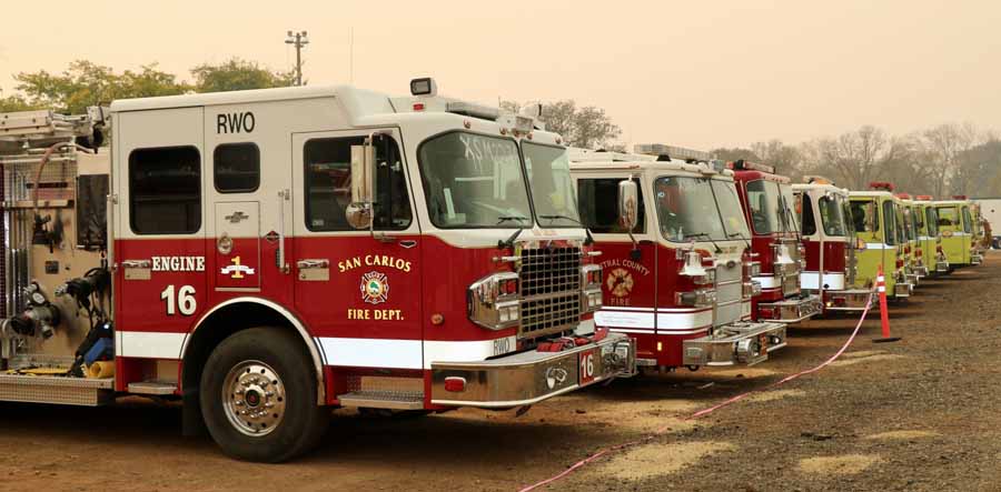
Firefighters came from long distances to assist suppress the Camp Fire, CAL FIRE photo.

The resources assigned to the fire include 622 fire engines, 97 hand crews, 21 helicopters, 107 dozers, and 71 water tenders for a total of 5,139 personnel.

map Camp Fire November 12 2018
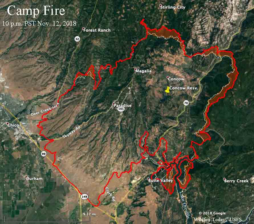
The red line on the map was the perimeter of the Camp Fire at 10 p.m. PST November 12, 2018. The white line was the perimeter about 24 hours before.

CAL FIRE releases map showing status of structures affected by Camp Fire

The fire has burned more than 117,000 acres at Paradise, California east of Chico.

map structures destroyed camp fire california
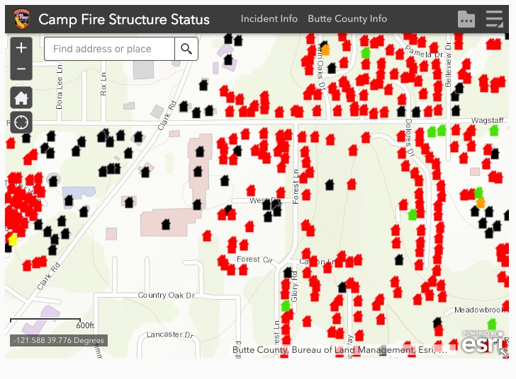
Example of data collected about damage to structures in the Camp Fire. Scroll down to see the interactive map.

The California Department of Forestry and Fire Protection (CAL FIRE) has released a map that shows the status of structures affected by the Camp Fire. The blaze has burned more than 117,000 acres at Paradise, California east of Chico.

(To see all articles on Wildfire Today about the Camp Fire, including the most recent, click here.)

The data is work in progress and not all areas have been surveyed for damage. The information from the field inspections is subject to change. It appears that the data is not restricted to just structures in Paradise, CA.

To see the map, click above on the “Terms” and then “OK”. After you read the Information, you may want to click on the “X” to remove the box that covers half of the screen.

If the map above fails to work, an alternative is to view it here.

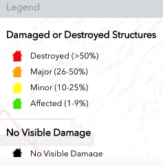
The legend for the map is below:

legend map fire structures damaged

CAL FIRE reports that 6,453 residences and 260 commercial structures have been destroyed in the Camp Fire.

Congratulations to ESRI and CAL FIRE for developing and releasing this useful tool.

(To see all articles on Wildfire Today about the Camp Fire, including the most recent, click here.)

Fire officials release list of structures burned in Camp Fire

The Butte County Sheriffs’ Office has confirmed 29 fatalities in the burned area

map Camp Fire Paradise California wildfire
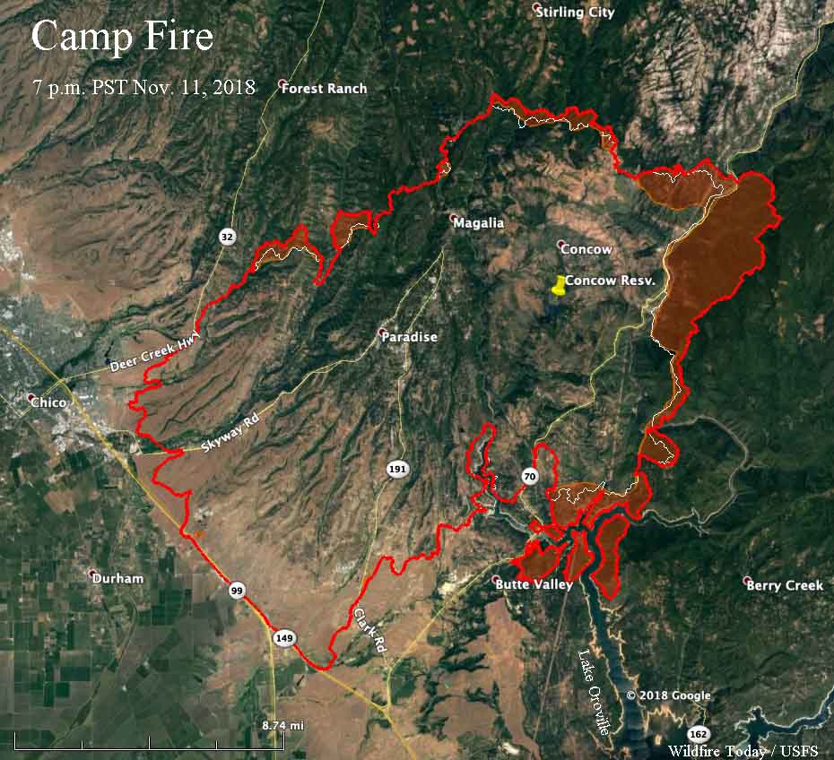
Map of the Camp Fire. The red line was the perimeter at 7 p.m. PST November 11, 2018. The white line was the perimeter about 24 hours before. Intense heat is indicated by the red shaded areas. Click to enlarge.

(UPDATED at 7:35 a.m. PST November 13, 2018)

Since the article below was published the California Department of Forestry and Fire Protection has released a map that shows the status of structures affected by the Camp Fire. The new map is still incomplete and is a work in progress.


(Originally published at 8:48 a.m. PST November 12, 2018)

The town of Paradise, California has released a partial list of structures that have been destroyed or at least 50 percent damaged in the Camp Fire. The surveys to assess the damage are ongoing and so far the list only covers 695 structures. The official estimate is that 6,453 homes have burned.

(To see all articles on Wildfire Today about the Camp Fire, including the most recent, click here.)

As of Sunday afternoon the Butte County Sheriffs’ Office had confirmed 29 fatalities in the burned area, while 228 people are still considered missing and unaccounted for. Some of the missing could be in shelters or no longer have cell phones. More than 100 were removed from the list after they were found.

The Sheriff’s Office has set up phone lines for a Missing Persons Call Center where the public can provide and receive information about missing individuals.

The numbers are:
530-538-6570
530-538-7544
530-538-7671

The Camp Fire was very active on the east side Sunday, spreading for over two miles east of Concow and spotting across the north end of Lake Oroville. The east side was less active, but still added about 1,000 acres southwest of Magalia.

CAL FIRE is reporting that the fire has burned 113,000 acres, but the agency often intentionally under-reports the size of large fires by 10 to 15 percent.

The homes of at least 53 firefighters burned in the Camp Fire, according to the International Association of Fire Fighters. The organization set up a disaster relief center for firefighters in Chico and so far have helped more than a dozen emergency responders.

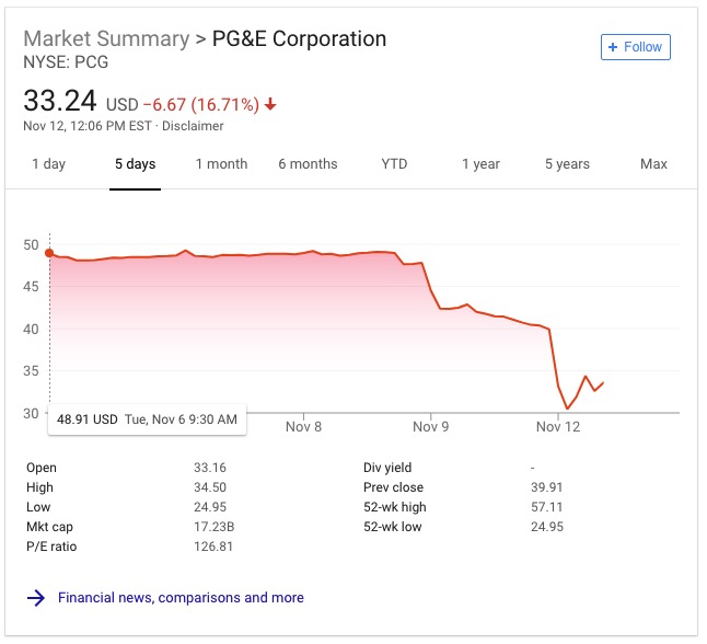
Pacific Gas & Electric disclosed to the Public Utilities Commission that one of their high voltage power lines had a disruption in service on Pulga Road near the Camp Fire at 6:15 a.m. the day it started, November 8. The fire was reported at 6:29 a.m. In the following days the stock price plunged 33 percent.
PG&E stock price plunges