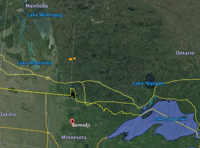
The National Interagency Fire Center has mobilized two BAe-146 air tankers and one King Air lead plane to assist the Canadian provinces of Ontario and Manitoba. Tankers 10 and 41 will be working out of the air tanker base at Bemidji, Minnesota 86 miles south of the US/Canadian border.
The aircraft were ordered primarily for the Kenora #18 Fire that straddles the border between Manitoba and Ontario (the brown dots in the map below). But they could be used for fires in either province.
According to the U.S. National Interagency Fire Center, Canada has not requested U.S. assistance specifically for wildfires in Alberta. The aid, they said, was requested through a bilateral firefighting assistance agreement with the Canadian Interagency Fire Center (CIFC). At this time, Canada has not requested additional resources or assistance from the U.S., though NIFC and the CIFC are frequently communicating.
I have seen chatter in recent days, here and elsewhere, very critical of both the United States for not sending firefighters to help out with the large wildfire in Alberta, and of Canada for not asking for help. Alberta Wildfire Management has said they have enough firefighting resources and don’t need international assistance. We checked with Jennifer Jones, a spokesperson for the U.S. Forest Service at the National Interagency Fire Center, and she confirmed that the United States government has not been asked by Canada for any resources.
It is unfortunate that this natural disaster has turned into a political football in some circles. Generally wildland firefighters are isolated from politics, other than depending on politicians for funding and occasionally succumbing to pressure to put air tankers in the sky even though they know that in certain conditions they will be completely ineffective. Firefighters call the retardant delivered to a fire under those conditions “CNN drops” — made for television — simply to appease the public and reduce the pressure felt by politicians. Thankfully CNN drops are rare.
But this pressure to send United States firefighters or hardware to Alberta falls into that same category. It would be a CNN deployment. Photos would be taken of firefighters boarding planes headed north, and then lining up at an Incident Command Post in Alberta.
The fire management personnel in Canada say they’ve got this. The United States, Russia, Mexico, Australia, Taiwan, Israel and the Palestinian Authority all offered help, according to John Babcock, a Global Affairs Canada spokesperson, but it is not needed.
Canada and the U.S. have often helped each other out, lending ground personnel and aircraft back and forth to assist during unusually busy wildfire seasons. There is no hesitancy to do this. People criticizing politicians and fire management personnel about a perceived lack of sharing need to calm down. Let the professionals decide what they need and don’t need. To a firefighter, a fire is not an emergency. It’s what they do.
If Alberta needs help, they’ll ask for it. If they ask, the U.S. will send resources north.
These first two maps are updated versions of the wildfire smoke maps down below. The smoke has gotten a little closer to the northeast United States.
Wildfire Smoke map, Weatherunderground, 4:30 p.m. May 8, 2016Wildfire Smoke map, NOAA 3:17 p.m. May 8, 2016
****
(Originally published at 12:31 a.m. MDT, May 8, 2016)
Wildfire smoke, at 12:05 a.m. May 8, 2016. WeatherUnderground
The fires in Alberta, Canada continue to create smoke that drifts into into Saskatchewan, Manitoba, the central United States, and many areas in the eastern U.S.
Wildfire smoke map generated at 10:24 p.m. May 7, 2016. NOAA.
To see the most current smoke reports on Wildfire Today, visit the articles tagged “smoke” at https://wildfiretoday.com/tag/smoke/
The massive wildfire in Alberta, Canada continues to grow. Smoke from the fire even reached Florida this afternoon. pic.twitter.com/vXnFxSozya
The homeowners gave Storyfull News permission to post this video. Apparently the home in Fort McMurray, Alberta had a security camera with a live feed over the internet.
More information about the huge fire at Fort McMurray, Alberta that at the last count has burned about 1,600 structures and 387,000 acres (157,000 hectares).
“#ymmfire” refers to the airport code for the Fort McMurray International Airport in Alberta. The entire population of the city, more than 80,000, was ordered to evacuate when it became obvious it was going to be overrun by the fire.
Below is an excerpt from a May 4, 2016 article at Slate about the weather in Canada:
…Canada’s northern forests have been burning more frequently over recent decades as temperatures there are rising at twice the rate of the global average. A 2013 analysis showed that the boreal forests of Alaska and northern Canada are now burning at a rate unseen in at least the past 10,000 years. The extreme weather of recent months is also closely linked with the ongoing record-setting El Niño conditions in the Pacific Ocean, which tends to bring a warmer and drier winter to this part of Canada. Last month, Canadian officials mentioned the possibility of “large fires” after over-winter snowpack was 60 to 85 percent below normal and drought conditions worsened.
This week, a strong atmospheric blocking pattern—a semi-stable extreme arrangement of the jet stream—reinforced an unseasonable heat wave and helped temperatures reach 90 degrees Fahrenheit (32.2 degrees Celsius) on Tuesday in Fort McMurray, 40 degrees Fahrenheit above normal, eight degrees above the daily record high, 15 degrees warmer than Houston, and the same temperature as Miami. While fleeing, some evacuees had to turn on their air conditioners…
THIS ARTICLE WILL NO LONGER BE UPDATED. We started a fresh thread on May 16 and will update it as needed.
(UPDATE at 9:41 p.m. MDT, May 9, 2016)
On Monday evening Alberta Wildfire Management updated the size of the huge fire in the Fort McMurray area, now saying it is 204,000 hectares, which is over half a million acres (504,000 acres) and 788 square miles.
The cooler and more humid weather in the forecast for the next few days should give firefighters a better chance to make some progress in slowing the fire down in certain areas. A few locations received some light rain over the last day or two.
Alberta Wildfire Management revised the reported size of the Fort McMurray fire to 161,000 hectares, an increase of 4,000 over this morning’s figure.
The Alberta government has not responded to an offer from Russia to supply ground and aerial resources to assist with the fire.
Below is an excerpt from an article at ctvnews:
…The offer involves sending converted Ilyushin Il-76 transport planes — the kind occasionally leased by the Canadian military — that can dump as much as “42 tons of fire retardant into fire spots,” according to a statement on the web site of Russia’s Civil Defence, Emergencies and Elimination of Consequences of Natural Disasters.
In addition, Moscow said it has “rescuers and specialists with necessary equipment” ready to help on the ground, if need be…
****
(UPDATED at 10 a.m. MDT, May 8, 2016)
The fire at Fort McMurray, Alberta did not grow a much as expected on Saturday. The satellite detections of heat Saturday night showed some expansion on the southeast side but there were no major additions to the footprint. Sunday morning Alberta Wildfire Management is reporting the same size as 24 hours before, 157,000 hectares (387,000 acres). Perhaps they will show a revised figure when they get a chance for a mapping flight.
Map showing heat detected by a satellite on the Fort McMurray fire. The most current heat (some of the red dots) on the map were detected at 10:43 p.m. May 7, 2016.
In the video below Wildfire Manager Chad Morrison gave an update on the fire as of Saturday.
The weather on Sunday could promote more growth of the fire on the east and northeast sides. The high at Fort McMurray will be 65 °F under partly cloudy skies, with 20 percent relative humidity and 18 mph winds out of the west-southwest.
Aerial footage, below, of Fort McMurray looks at the destruction in the Abasand and Beacon Hill neighborhoods.
Alberta Wildfire Management reported Saturday morning that the fire near Fort McMurray has burned 157,000 hectares (387,000 acres). That is almost double the size reported Friday morning, but many of those additional hectares were acquired on Thursday.
Map showing heat detected by a satellite on the Fort McMurray fire. The most current heat (some of the red dots) on the map were detected at 11:47 p.m. May 6, 2016.
On Friday the fire continued to spread to the southeast and is now on both sides of Highway 881 southwest of Anzac. There was also significant growth north of Fort McMurray on the east side of Highway 63.
The weather on Saturday will be conducive to additional spread of the fire to the east and northeast. The temperature at Fort McMurray will reach 80 °F, with 19 percent relative humidity and west-southwest winds of 6 to 13 mph.
On many recent days the temperature in this area of Alberta has been far higher than average. Historically the average high at Fort McMurray in April is 49 °F, and in May is 63 °F. On Tuesday the high temperature set a new record, eight degrees above the record high for that date.
On Friday about 1,200 vehicles with residents who had fled north from Fort McMurray and then became stranded were escorted south back down Highway 63 through the fire and the heavily damaged city. They will relocate at least temporarily in emergency shelters or with friends or family far from the fire. Helicopters hovered overhead to watch for flare-ups along the highway, one of which halted the convoy for an hour.
Others are being airlifted out of the fire zone, as were 7,000 on Thursday, according to authorities. About 15,000 people remain stranded north of the devastated city, but not all will leave, Alberta Premier Rachel Notley said.
The fires in Alberta continue to send smoke into Saskatchewan, Manitoba, the central United States, and many areas in the eastern U.S. To see the most current smoke reports on Wildfire Today, visit the articles tagged “smoke” at https://wildfiretoday.com/tag/smoke/