Fire in Jasper National Park requires evacuation of park visitors by helicopter

Fire near Excelsior Creek
Fire near Excelsior Creek in Jasper National Park in Alberta, Canada. Photo by Parks Canada.

(UPDATED at 3:40 p.m. MT, July 10, 2015)

Map of fire in Excelsior Creek
The brown and red dots represent heat detected by a satellite of a fire in Excelsior Creek in Jasper National Park. The most recent detections were at 5:18 a.m., July 10, 2015.

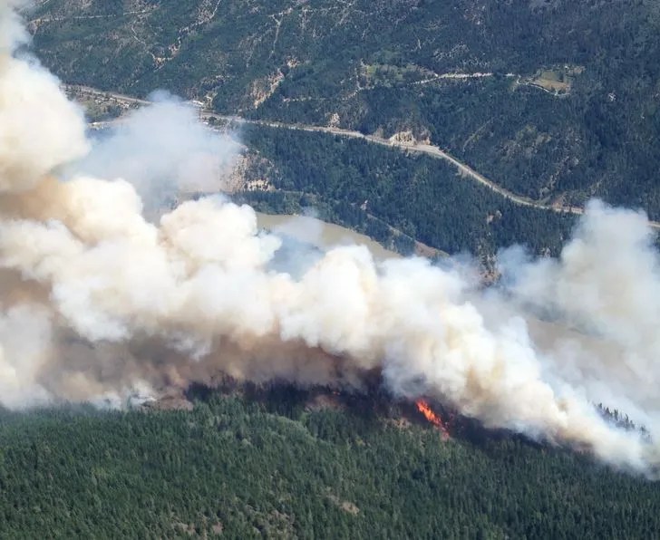
The map above shows the approximate location of the fire at 5:18 a.m. on June 10 in Excelsior Creek in Jasper National Park in Alberta. The fire in the Maligne Valley is approximately 9 miles (15 km) east of the community of Jasper.

Friday morning it was reported to have burned approximately 5,000 hectares (12,000 acres). Friday afternoon a light rain fell in the area, slowing the spread for a while.

****

(Originally published at 10 a.m. MT, July 10, 2015)

With a wildfire in Jasper National Park in Alberta, Canada spreading rapidly, fire managers evacuated about 82 people, including 52 that were flown off the Skyline trail by helicopter.

The fire was reported at 3:30 p.m. on Thursday approximately 15 km (9 miles) south of the municipality of Jasper. Visitors are being evacuated from the Maligne Valley, the Skyline trail, and Maligne Lake.

Below is an excerpt from the Edmonton Journal:

“We see this as the highest priority fire in the national parks right now,” said David Smith, a fire and vegetation specialist for Jasper who is also serving as incident commander.

According to Smith, the fire is between 200 and 250 hectares [494 to 618 acres] in size, moving at about 15 metres [49 feet] per minute. As temperatures drop and the sun sets, the fire is expected to “settle down” overnight.

Crews are currently fighting the fire by air only as conditions prove too hazardous for ground crews at this time. Despite the high number of fires across the prairies, there are crews slated to arrive in Jasper Friday, before noon.

Though the fire is currently out of control, Smith said people in Jasper need not worry about their safety. At this time there are no park facilities in the way of the fire and because the wind is pushing the fire up to Maligne Lake, Smith said, “the town of Jasper is 100-per-cent safe.”

The video below is a 2-hour time-lapse of the smoke from the fire, shot Thursday from 6 p.m. until 8 p.m., compressed to 30 seconds.

These next photos are general shots of fires and firefighters in Alberta, sourced from the Facebook page for “Alberta Wildfire Info”.

Fire north of Slave Lake
Fire north of Slave Lake, July 9, 2015
Firefighters from Jalisco, Mexico
Firefighters from Jalisco, Mexico assisting with wildfires in Alberta.

Alberta firefighters

Alberta firefighter

Time-lapse of a fire in Canada

This is an interesting video of a wildfire in Canada. Contrary to the description with the video that we referenced earlier, it was shot in Nelson, British Columbia. (Thanks Fis and Keith.)

In the second half of the video the fire appears to be influenced by a down-slope breeze.


Acres burned in Alaska and Canada far ahead of average

Big Beaver Creek Fire
The Alaska Highway was closed to all traffic due to aggressive fire behavior observed on the Big Beaver Creek Fire in British Columbia Wednesday afternoon. The highway is closed between 386 km (Mile 250) and 418 km (Mile 260). British Columbia Wildfire Service photo.

It is barely mid-summer and wildfire activity in Alaska and western Canada has been much higher than average for this time of the year. As of July 8, the number of acres burned in Alaska is the second highest ever recorded for an entire year — 2004 holds the present record, but on a year to date basis, the state now is ahead of the same date in 2004 for acres burned.

The area blackened in Canada already exceeds the annual 10-year average for an entire year. The government has activated about 1,000 military personnel to help fight wildfires in Saskatchewan. Firefighters from eastern Canada have been mobilized to assist in the western provinces, and one BAe-146 air tanker from Missoula, Montana is also lending a hand.

Canada weeks area burned through July 1, 2015
Canada area burned on a weekly basis through July 1, 2015.

Alaska is also receiving help from firefighters in the lower 48 states. For example on Tuesday five 20-person crews were dispatched from California to Alaska, while snow flurries have been occurring for the past several days on the Inyo National Forest in California. Other Forests in the state received rain on Wednesday.

Here are some wildfire numbers, current on July 8, 2015:

  • United States: 30,017 fires, 3,821,726 acres
  • Alaska: 650 fires, 3,208,107 acres
  • Canada: 4,672 fires, 6,546,562 acres
Canada fires, July 8, 2015
Alaska Fires July 8, 2015

Contract faller killed on British Columbia fire

The British Columbia Wildfire Service released this information late Sunday night, July 5, 2015:

We sign off with heavy hearts tonight. We were saddened to learn that a contract tree faller working with us on the Old Sechelt Mine fire suffered a fatal injury while felling a danger tree earlier today. Our thoughts and prayers go out to his friends, family and co-workers.

This is a tragic reminder of the dangerous work being done by personnel across the province to respond to wildfires.

Our sincere condolences go out to the family, friends, and co-workers.

The Old Sechelt Mine Fire has burned 80 hectares (198 acres) since it was discovered July 2 two km northwest of Sechelt.

UPDATE at 7:30 p.m. MT, July 6, 2015: Kelowna Now reports that the coroner has identified the faller as John Joe Phare, age 60, from Roberts Creek.

Thanks and a tip of the hat go out to Mike.

Smoke is helping to control wildfires in Canada

Satellite view, smoke Canada fires
A satellite view of the location of fires in Canada July 2, 2015, represented by the red dots. Smoke can be seen drifting to the south and southeast.

You don’t usually think of smoke benefiting firefighters, especially their health, but the pollutants over a very widespread area are modifying the weather, making it a little easier to corral the numerous wildfires in some areas.

Below is an excerpt from The Weather Network.

Thursday, July 2, 2015, 5:14 PM – Even as plumes of heavy smoke from Alberta and Saskatchewan wildfires force thousands from their homes, officials find a silver lining, as the smoke is actually keeping the fires more under control.

Evacuation centres in central and southern Saskatchewan are reportedly housing at least 5,000 people as of Thursday, all displaced from their homes by thick smoke drifting down from wildfires burning in northern parts of the province. The evacuations were prompted by the significant health risk this smoke represents, and Environment Canada has issued special air quality statements for northeastern Alberta, all of Saskatchewan and all but the northeastern regions of Manitoba in response.

Despite this health risk, though, the thick smoke is actually having a beneficial impact on the very fires that are producing it in the first place.

“As much as it’s not good for people, because the cloud layer filled with smoke and is so thick, our temperatures are roughly 10 degrees cooler and our humidity is 10 to 15 per cent higher,” said Steve Roberts, Executive Director of Saskatchewan’s Wildfire Management Branch, according to the Canadian Press. “That combination means the fire activity drops significantly.”

“It’s helped us secure, especially, those fires that are close to communities by putting people on the ground and getting some hose lines in place.”

But, the smoke is a double-edged sword. Sometimes the reduced visibility grounds firefighting aircraft:

The video below of a wildfire in Saskatchewan is stunning. It appears that the photographer was quite close to a very, very active fire.

If your device can’t handle the video above, try it at this site.

To see the most current smoke reports on Wildfire Today, visit the articles tagged “smoke” at https://wildfiretoday.com/tag/smoke/

Cisco Road Fire south of Lytton, B.C.

(UPDATE at 10:27 a.m. PT, June 12, 2015)

Cisco Road Fire
Cisco Road Fire, June 11, 2015. Photo by B.C. Wildfire Management Branch.

The British Columbia Wildfire Management Branch says the Cisco Road Fire south of Lytton, B.C. has been mapped at 1,500 hectares (3,700 acres). The size will increase as the fire crews conduct strategic burning operations.

Cisco Road Fire
Cisco Road Fire, June 11, 2015. Photo by B.C. Wildfire Management Branch.

Firefighters will be watching for high winds today — predicted to be southerly for most of Friday morning, with the chance of a shift to northerly later in the afternoon. Crews did experience a trace amount of precipitation on some areas of the fire Friday morning.

****

Cisco Road Fire
Cisco Road Fire south of Lytton, BC at 3:22 pm PT June 11, 2015.

(UPDATE at 5:29 p.m. PT, June 11, 2015)

The British Columbia Wildfire Management Branch said at 2:58 PT that the new wildfire, now named Cisco Road Fire, west of the Fraser River south of Lytton (map) has burned about 600 hectares (1,482 acres) and is zero percent contained:

This fire is displaying aggressive fire behaviour (Rank 5) and is located in difficult terrain [Rank 5 fire behaviour is a crown fire that has the potential for short-range spotting] . Winds 40 gusting 60 km/hr [25 mph gusting to 37 mph] from the south are continuing to challenge suppression efforts. There are currently 22 firefighters on site, with 20 more en route. Three helicopters are providing bucking support for ground crews.

An Evacuation Alert and Order have been issued by the Lytton First Nations Band for nearby First Nations communities.

I wonder about the future of the live cam that is getting these great photos? If the wind shifts to come out of the north, it will probably be toast, unless it can be evacuated, or unless it has sufficient clearance around it. I think the cam is looking north, and that jives with the south wind described above..

****

(Originally published at 2:32 p.m. PT, June 11, 2015)

Lytton wildfire
An image grabbed from a live web cam of a fire south of Lytton, B.C. at 3:22 p.m. MT, June 11, 2015.

A new wildfire south of Lytton, B.C. has gotten a running start up a steep slope, as you can see in the photo that was captured by a live camera operated by Lyttonnet. Not much information is available yet, but CBC News reported at 1:57 p.m. PT that it was 150 hectares (370 acres) on the west side of the Fraser River. The B.C. Wildfire Management Branch says the fire was reported around noon and is threatening structures near Lytton, roughly 100 kilometers north of Hope.

Here is another photo grabbed from the live camera earlier in the day:
Lytton BC fire