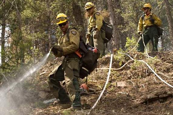
Colorado Springs FD protects a structure on the Black Forest Fire

Yesterday we posted two videos produced by the Department of Defense showing a wildland firefighter’s view from his helmet camera while fighting the Black Forest Fire near Colorado Springs, and another that featured the military’s participation in the firefighting effort on the Fire.

Now we have another, this time produced by the Colorado Springs Fire Department which gives the viewer a close-up look at how one of their engine crews protected a residence as the fire approached. The five-minute video summarizes what the crew did over a two-hour period to keep the house from burning, which was made more difficult by a ring of mulch the homeowner had carefully placed around the house. If you have never fought a wildland fire or been engaged in structure protection as a fire spread toward the building, you will be impressed by what it can look like from a firefighter’s point of view.

Congratulations to the Colorado Springs Fire Department for putting this video together.

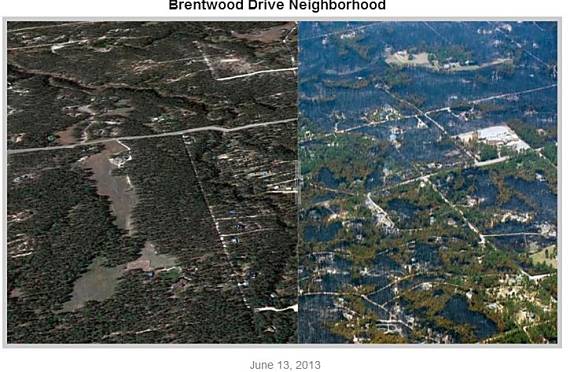
Black Forest Fire, before and after

Black Forest Fire, Denver Post, before-after
Black Forest Fire, Denver Post, before-after (this is an example, and will not slide back and forth)

The Denver Post has put together some before and after photos of the area where the Black Forest Fire is burning near Colorado Springs, CO. The before photos were harvested from Google Earth, and the after photos were taken within the last day or two. After you go to the site (don’t try it on the sample above), with your mouse, grab the slider and move it back and forth. The photos don’t always line up, but it’s a good way to see where crown fires took out all of the trees, and to get an idea of how much fuel (vegetation) was close to the structures.


Thanks go out to Dick

Black Forest Fire, Colorado Springs

(UPDATE at 9:25 a.m. MT, June 18, 2013)

The video below was shot by KKTV chief photojournalist Mike Petkash. It was posted Tuesday morning, June 18.

An update from the El Paso County Sheriff’s office lists 502 primary residences that were destroyed in the Black Forest Fire and another 18 with partial damage.

American Red Cross Disaster Assistance Teams are doing assessments within the fire perimeter. Utility crews continue assessing and securing service to residences for future re-entry. Excess resources are being released as incident objectives are being met. Firefighters continue to mop up and secure around structures to prevent further loss.

****

(UPDATE at 11:47 a.m. MT, June 17, 2013)

A tweet from KKTV in Colorado Springs:


That is the first time I have heard of this happening — survivors from a massive, very destructive wildfire less than a year before hold a picnic for survivors of another even more destructive wildfire that occurred just a few miles away.

Thunderstorms on Sunday brought 0.11 inches of precipitation to the Black Forest Fire area, which aided firefighters in their mop up efforts. The storm also produced lightning that ignited three new fires in the burn area which were quickly suppressed by firefighters, according to Incident Commander Rich Harvey.

The size of the fire has been more accurately determined to be 14,280 acres; on Saturday it had been listed at 15,500 acres. The cost of fire suppression is estimated at $5.5 million and 4,100 people are still under mandatory evacuation orders. The Denver Post has a map showing evacuation areas and the locations of structures that have burned.

Firefighters are placing flagging at residences, and writing on it the the date, time, and the name of the crew that checked and mopped up the area.

Incident Commander Rich Harvey told CNN on Sunday, June 16:

The perimeter work is done, now we’re focused on coming interior and making sure that all the heat that could eventually create sparks that could get over our line are done — we call it mop up.

At an 11:15 a.m. MT briefing on Monday, IC Harvey said the fire is 75 percent contained. (More information about “containment”.)

A Monday morning news release from the IMTeam detailed some of their plans for the day:

A continuing threat exists to structures within the fire perimeter due to the potential for extreme fire behavior from gusty winds from developing thunderstorms. The potential for re-burn from remaining hot spots within the ground fuels remains a concern. Firefighters will continue to grid the fire area for hotspots, especially around structures.

A media tour scheduled for Monday morning during which members of the press were going to be transported around the fire in a bus was postponed and no new date was established.
Continue reading “Black Forest Fire, Colorado Springs”

Dispatcher may have mishandled 911 call about Waldo Canyon Fire

If a 911 dispatcher had handled an incoming call differently, it is possible that the disastrous Waldo Canyon Fire could have been suppressed long before it killed two people and burned 18,000 acres and 347 homes in Colorado Springs.

On April 19 we covered the time line on the fire, including the fact that it took firefighters 16 hours to find it after the first smoke report at 7:50 p.m. on June 22, 2012. Between 7:30 a.m. and 7:50 a.m. the next day another 911 caller reported the fire and indicated that he had been running on a trail and apparently had been close to the fire and knew the actual location. But the dispatcher said the Forest Service was responding, and thank you. Four hours later at noon firefighters finally found the fire 16 hours after the first report.

KKTV transcribed the 911 call from the runner:

Dispatcher: “On Saturday, June 23, 2012 at 7:50 a.m.”

Dispatcher: “This is the El Paso County Dispatch.”

Caller: “I’m calling on the suspected Waldo fire; I was running the trail today and went up on one of the dog legs after I smelled a little bit of smoke. There’s a spot about a couple hundred feet wide that’s still smoldering a little bit.”

Dispatcher: “Right….Pueblo Forest Service checked on that last night they said that they would be sending up another unit first thing this morning to check on it, but they are aware of it and they will be up there shortly this morning. Okay?”

Caller: “Yeah. I just wanted to make sure.”

Dispatcher: “Sure. Thank you.”

The El Paso County Sheriff’s Office report about the fire mentioned the runner’s call:

…[The caller] was advised that responding agencies were aware of the report. The reporting party’s contact information or specific location was not captured or reported to responding agencies as the dispatcher believed responding agencies were aware of the location of the fire.

Later in the Sheriff’s report, the call was referred to again:

…Pinpointing more specific location would potentially expedite response. Obtaining specific information from witnesses as to their location with respect to the sighting of smoke/fire and responding to reporting parties’ locations as they were reporting signs of the fire would more narrowly identify the location of the fire.

There is no indication in the reports that the U.S. Forest Service requested a helicopter or any other aerial resources to assist in locating the smoke, which was in the Pike National Forest just west of Colorado Springs.

Colorado Springs Fire Chief to retire

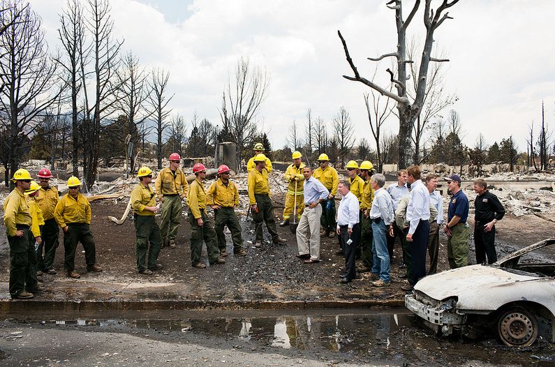
President Obama at Waldo Canyon Fire
President Barack Obama views fire damage with firefighters and elected officials at the Waldo Canyon Fire in Colorado Springs, Colo., June 29, 2012. (Official White House Photo by Pete Souza; click to enlarge)

Rich Brown, the Chief of the Colorado Springs Fire Department, has announced his retirement. Even though he has been criticized for the way the fire department handled the 2012 Waldo Canyon fire that killed two residents and burned 347 homes, some employees within the city’s administration have said that Chief Brown is simply done, and ready for retirement after serving for 32 years. He became Chief in December, 2011, and his retirement is effective April 30, but he will remain on the city’s payroll as a consultant for six months at his annual salary of $147,657 plus benefits, according to an article in the Colorado Springs Gazette.

A person could wonder if Chief Brown’s job has been a lot less fun since the details about how his department responded to the Waldo Canyon fire have become public.

An excellent article in the Colorado Springs Independent last December was written after an examination of hundreds of documents including reports written by firefighters working on the fire. If the article is correct, and I have no reason to believe it is not, it exposes complete failures in pre-incident planning, qualification and training of fire department personnel, evacuation planning and execution, logistics, daily incident planning, strategy, and tactics. Apparently this large, modern city with an extensive, very vulnerable wildland-urban interface was completely unprepared to manage a large wildland fire and evacuations.

The article does not criticize firefighters. It points out the failures in preparedness and management of the fire by upper level officials, before, during, and after the incident.

Sheriff’s office releases report about Waldo Canyon Fire

Vandenberg Hotshots on the Waldo Canyon Fire. Photo by Kari Greer

In Colorado the local sheriff is responsible for the suppression of wildfires in unincorporated areas, regardless of the amount of training and experience the elected official may have in the management of wildfires. Yesterday the El Paso County Sheriff’s Office released a 27-page report about the Waldo Canyon Fire that blackened over 18,000 acres, burned 347 homes, and killed two people when it spread into Colorado Springs June 26, 2012. We can add this report to the two already issued by the city of Colorado Springs, and hopefully, a report to be released some day by the U.S. Forest Service which initially had jurisdiction for the fire that started in the Pike National Forest just west of the city.

Even though the most serious impacts of the fire were in Colorado Springs, the city refused to delegate authority for the Incident Management Team to manage the fire within their city limits, and pretty much operated on their own as hundreds of homes in the Mountain Shadows area burned and two people were killed. The County Sheriff’s report referred to this in an indirect way, as seen below:

“In preparation for the arrival of the Type 1 Team, Delegations of Authority were received from all affected jurisdictions except one agency. ****Note**** Delegations of Authority in this context refer to documents that permit state and national resources to provide assistance in local jurisdictions. These documents do not diminish or relinquish the responsibility of local authority.”

Here are some key developments during the first five days of the fire:

Friday, June 22, 2012. The first smoke report was at 7:50 p.m. The U.S. Forest Service and several agencies responded, but did not locate the smoke. All of the firefighters were released at 9:48 p.m. by the USFS who had assumed command of the incident.

Saturday, June 23, 2012. The next morning at 6:58 a.m. the USFS was back on scene. At 7:30 a.m. there was another report of smoke in the area. At noon after several other reports of smoke, the fire was located. About 20 minutes later more firefighting resources were ordered including a single engine air tanker. This is the first indication of any aviation resources, helicopters or air tankers, being requested for the fire. Shortly after that the Colorado Springs Fire Department ordered the voluntary evacuation of several areas. That afternoon a Type 3 Incident Management Team assumed command of the fire and a Type 1 IMTeam was ordered. Mandatory evacuations for some areas began at 3:12 p.m.
Continue reading “Sheriff’s office releases report about Waldo Canyon Fire”