117 Fire burns structures south of Colorado Springs

The sheriff’s office reports 10 structures have burned

Above: satellite photo showing the location of the 117 fire south of Colorado Springs. The red dots on the map represent heat detected by a satellite at 2:30 p.m. MDT April 17, 2018.

(UPDATED at 11:33 a.m. MDT April 18, 2018)

A more accurate estimate of the size of the 117 Fire between Colorado Springs and Pueblo puts it at 41,000 acres. Military helicopters, Chinook and Blackhawks, are assisting firefighters by dropping water.

A deputy sheriff said he was driving at 35 mph near the fire Tuesday and it was moving faster than he was.
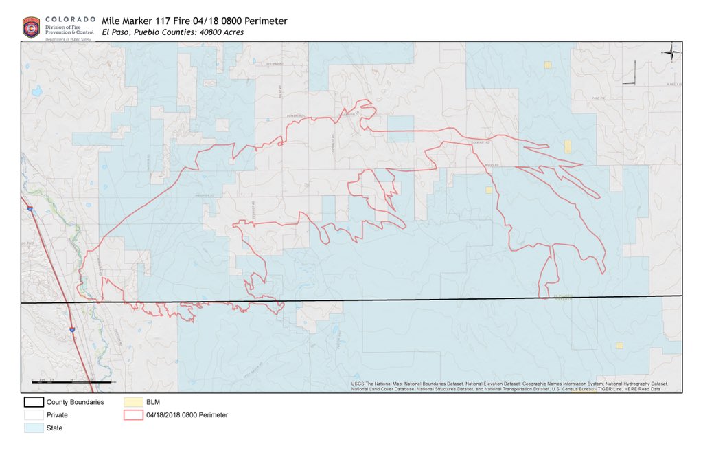
Map of the 117 Fire
Map of the 117 Fire, at 8 a.m. MDT April 18, 2018

***

(UPDATED at 7:15 a.m. MDT April 18, 2018)

The El Paso County Sheriff’s office reported Wednesday morning that the 117 Fire between Colorado Springs and Pueblo, Colorado has burned an estimated 60,000 acres. The fire is still active in El Paso and Pueblo Counties but the wind speeds recorded at Fort Carson and Pueblo have decreased Wednesday morning — calm to five mph, compared to gusts of 50 to 80 mph Tuesday afternoon.


The wind on Tuesday was too strong for helicopters, air tankers, or Colorado’s Multi-Mission Aircraft to fight or even map the fire, but officials hope to get the MMA into the air this morning to give firefighters a better idea of the scope of the blaze.

****

(Originally published at 9:38 p.m. MDT April 17, 2018)

The 117 Fire has burned at least 4,000 acres about halfway between Colorado Springs and Pueblo, Colorado. The sheriff’s office reports 10 structures have burned. The fire started Tuesday along the Interstate 25 corridor about halfway between Colorado Springs and Pueblo. It spread quickly pushed by very strong winds.

There are few public weather stations near the fire but a station north of Pueblo recorded sustained wind speeds between 9 a.m. and 2 p.m. of 45 to 60 mph gusting at more than 80 mph. The minimum relative humidity was four percent. A weather station at Fort Carson south of Colorado Springs had winds of 30 to 40 gusting above 50 mph during the same period.

Until about 2 p.m. the wind was out of the southwest. The extreme speed created a very narrow fire that grew seven miles to the northeast by 2:30 p.m. Monday. Later in the afternoon the wind shifted to come out of the south and then the southeast and east. The shifting direction could cause firefighters to be caught unexpectedly near a rapidly advancing flank or head of the fire.

The El Paso County Sheriff’s office announced mandatory evacuations on their Facebook page.

There are reports that a law enforcement patrol vehicle burned and a fire engine was damaged by the quickly spreading fire.

The county declared the fire a disaster and they are in negotiations with the state to take over the fire.

The area was under a Red Flag Warning Monday and Monday evening. The forecast for the 117 Fire area Monday night calls for 20 mph winds gusting to 30-40 decreasing to 7 mph by 8 a.m. Tuesday. The high temperature Tuesday should be 59 degrees with 13 percent relative humidity  along with much calmer winds.

The wind on Monday was far too strong to allow any helicopters or air tankers to take suppression action on the fire, but that will probably change on Tuesday.

Fort Carson reports 20 training related vegetation fires in last 12 months

Two recent fires started on the base burned a total of 5,000 acres, two homes, numerous outbuildings, and dozens of vehicles.

A spokesperson for Fort Carson, a U.S. Army base south of Colorado Springs, admits that 20 fires in the last 12 months have been a result of training activities on the base, according to KOAA. Below is an excerpt from their report:

On March 16, a fire caused by live ammunition training on a Fort Carson artillery range burned nearly 3,000 acres off Mountain Post property, destroying two homes, numerous outbuildings, and dozens of vehicles.  Sunday, a wildfire caused by shooting on the Cheyenne Mountain Shooting Complex public shooting range burned more than 2,000 acres and forced the total closure of a roughly 10-mile stretch of I-25 for more than an hour.

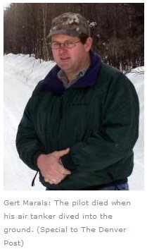
Gert MaraisLocal residents and elected officials are wondering if there is anything the base can do to reduce the number of fires started by training, such as eliminating dangerous activities during periods of elevated fire danger.

Ten years ago this month the pilot of a single engine air tanker was killed while helping firefighters on the ground contain a fire that started on Training Area 25 at Fort Carson. Wildfire Today wrote about the report released by the National Transportation Safety Board, which indicates there were very strong winds that day when Gert Marais died:

At the time of the crash, a U.S. Forest Service person on the ground who was directing the SEAT estimated that at the time of the crash the wind was out of the southwest at 30-40 knots. Winds at the Fort Carson airfield, 5 miles from the crash site, were between 20 and 40 knots from 1300 to the time of the accident at 1815.

Strong winds like occured on April 15, 2008 often indicate high wildfire danger if the relative humidity is low and the vegetation is dry.

Thanks and a tip of the hat go out to Bean.
Typos or errors, report them HERE.

Wildfire starts on Colorado military post, burns 2,100 acres

The Carson Midway Fire burned hundreds of acres in Colorado Friday, March 16, 2018. Photo credit: Tri-Lakes Monument Fire Protection District

Evacuations remained in place Friday night and several structures reportedly burned after a fire broke out on a Colorado military post and spread to surrounding areas, officials said. 

The fire, which started midday Friday in the southeastern portion of Fort Carson’s training area, burned approximately 2,100 acres in Pueblo and El Paso counties — on and off the Army post — by Friday night, according to the Pueblo County Sheriff’s Office. 

Firefighters from Fort Carson, near Colorado Springs, in conjunction with El Paso and Pueblo county agencies worked the Carson Midway Fire through the day Friday.

Air resources from Fort Carson worked with Bambi Buckets to assist fire fighters on the ground, officials said. Additional fixed-wing air assets have been requested and are on scene.

Approximately 100 Pueblo County residents living in the Midway Ranch area were evacuated. A large-animal shelter was also established at the Colorado State Fairgrounds.

The cause of the fire is under investigation.

Additional details about the number of structures affected were not immediately available.

Red flag warnings were issued across the region Friday. Gusty, dry conditions are forecast to return Saturday, according to the National Weather Service.

Stateline Fire burns more than 20,000 acres in New Mexico and Colorado

The fire is burning in the area where Colorado, New Mexico, and Oklahoma converge

Above: satellite image showing the Stateline Fire. Red indicates heat, and the burned area appears black.

(UPDATED at 9:15 p.m. MDT March 12, 2018)

Here is an update from fire officials at 9 p.m. MDT March 12:

“The Stateline Fire burning in Union County, north of Clayton, New Mexico is now 50% contained. An estimated 27,658 acres has burned, of which 16,898 acres is on state and private land in New Mexico, 10,750 in Colorado and 10 acres in Oklahoma.”

****

(Originally published at 7:20 p.m. MST March 10, 2018)

The Stateline Fire burning in Union County, north of Clayton, New Mexico, is currently estimated at 21,253 acres, of which 7,160 acres has crossed over into Colorado.  The fire started Thursday morning March 8 on private property in New Mexico.  There is no immediate threat to structures at this time. Fuels include piñon, juniper, oak, and grass. Currently there are more than 80 personnel from multiple agencies fighting the fire. The cause is under investigation.

The has also crossed from New Mexico into Cimarron County in Oklahoma, making it one of the few fires that have burned in three states.

Stateline Fire
Stateline Fire. Photo credit: Albuquerque Fire Department.

Thanks and a tip of the hat go out to L M.
Typos or errors, report them HERE.

Strong winds recorded in CO, NE, KS, and OK

Above: Map showing maximum wind gusts in Nebraska at 1:25 p.m. MST March 5, 2018.

(Originally published at 1:32 p.m. MST March 5, 2018)

As predicted in the Red Flag Warnings Monday morning, strong winds are are occurring in Nebraska, Colorado, Kansas, and Oklahoma.

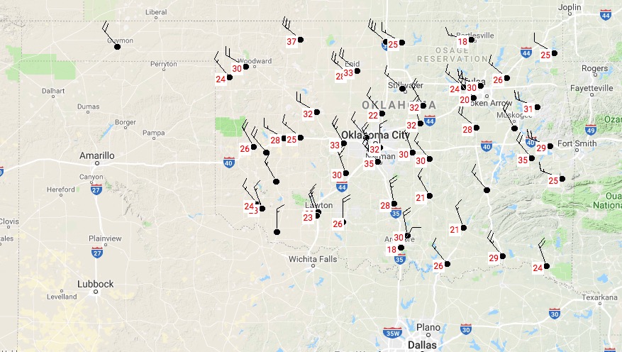
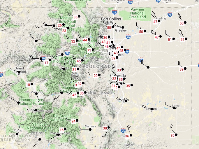
These maps of the four states show maximum wind gusts updated at 1:25 p.m. MST March 5, 2018.

Kansas

Kansas strong wind
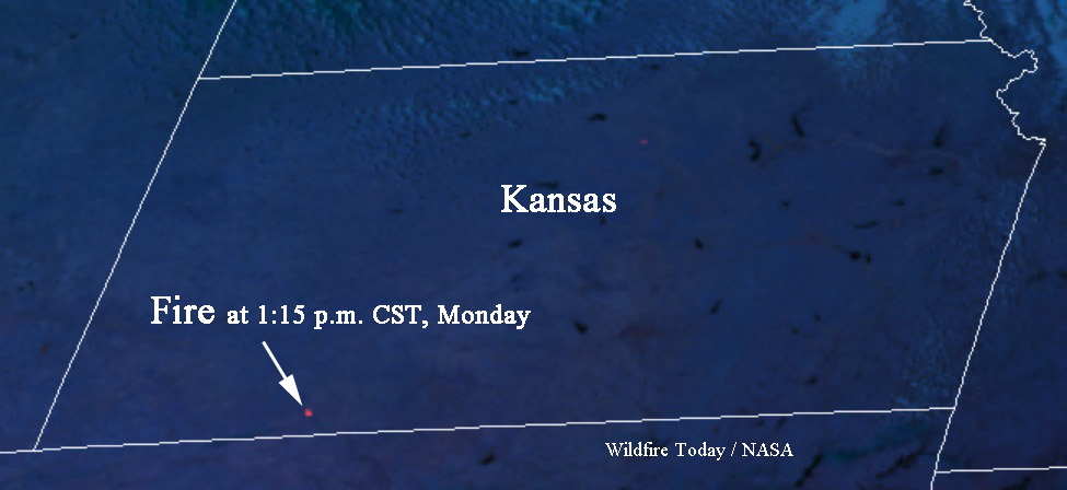
Matt told us about a fire in Clark County, Kansas. The GOES 16 satellite detected it.

fire clark county kansas
The map below shows a fire detected by a satellite in Clark County Kansas at 1:15 p.m. CST March 5. It is south of Dodge City and west of Ashland.

UPDATE at 1:54 p.m. MST March 5, 2018: the satellite is detecting another fire in Kansas, farther west, near Hugoton.

UPDATE at 3:19 p.m. MST March 5, 2018. The fire in Clark County is reportedly contained. That fire and the one farther west are no longer being detected by the satellite.

Oklahoma

Oklahoma wind

Colorado

Colorado strong wind

Three fires Sunday in eastern Colorado

The map above shows the location of three fires in Colorado March 4, 2018.

(Originally published at 7:21 p.m. MST March 4, 2018)

Three wildfires broke out in eastern Colorado Sunday while the area was under a Red Flag Warning. A weather station near Fort Carson recorded relative humidities in the single digits and wind gusts above 50 mph.

Fort  Carson Fire

A fire close to Fort Carson south of Colorado Springs burned 644 acres near a housing development. About 400 residents, some of them on the military post, were forced to evacuate and Gate 5 leading into the base was closed.

#grassfire on #fortcarson #toodry #norain #nosnow #cosprings

A post shared by Ethan Beute (@ethanbeute) on

Forest Ridge Fire

A fire southeast of Denver and south of Kiowa near CR 45 and CR 118 burned 370 acres and destroyed at least four homes and five barns. Residents in the area were told to evacuate and the Elbert County Fairgrounds sheltered 37 horses, 3 cats, & 6 dogs. By late afternoon firefighters had stopped the spread and officials lifted the evacuation orders.

Rabbit 22 Fire

The Rabbit 22 Fire burned 9,700 acres in the southeast corner of Colorado south of Holly and Granada.