Cold front drives numerous large wildfires in Kansas

Above: Large wildfires (red) in Kansas as detected by a satellite at about 1 p.m. MST March 6, 2017.

(UPDATED at 5:43 p.m. MST March 6, 2017)

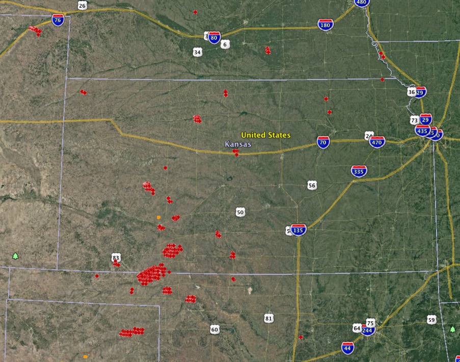
Below is an updated map showing growth of some of the fires in Kansas, especially the one 17 miles southeast of Meade, Kansas that burned from Oklahoma into the state. That one, using very rough satellite data, appears to be more than 130,000 acres.
map wildfires kansas
The red areas represent wildfires in Kansas detected by a satellite at 4:07 p.m. MST March 6, 2017.

There was a report, as yet unconfirmed, that in Kansas a tornado moved over a going fire.

****

(Originally published at 4:17 p.m. MST March 6, 2017)

Strong winds along with relative humidities in the teens and twenties are causing problems for firefighters in the western half of Kansas. The passage of a cold front is bringing sustained wind speeds of 30 to 40 mph with maximum gusts in the 40’s and 50’s.

On the map above we identified and very roughly mapped four of the largest fires. The acreages shown are estimates based on satellite detections of heat at about 1 p.m. MST on Monday. One of them has burned from Oklahoma into Kansas.

  • 53,000 acres; 17 miles southeast of Meade, Kansas. It is in Meade and Beaver Counties in Kansas, and Clark County in Oklahoma.
  • 6,500 acres; in Clark County 23 miles east of Meade, Kansas.
  • 7,000 acres; in Lane County Kansas 10 miles southeast of Dighton, Kansas.
  • 4,000 acres; in Rooks County Kansas just southwest of Stockton, Kansas. Residents in part of the city have been ordered to evacuate.

A fire in Logan County in the northeast corner of Colorado has burned 6,000 acres 20 miles northeast of Sterling.
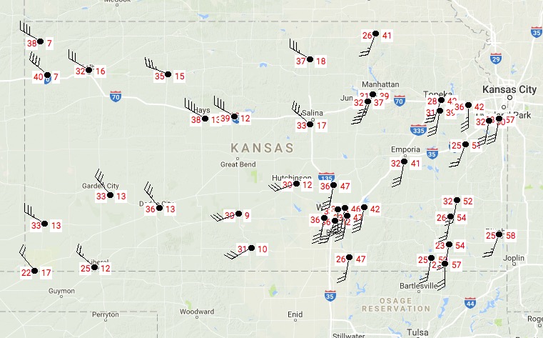
wind and rh in kansas wildfires map
In Kansas at 3:52 p.m. MST. Sustained wind speed on the left and relative humidity on the right.

Before the cold front passed the fires were driven by a southwest wind (see the animated radar map below). As the front passes the wind is shifting 90 degrees to come out of the northwest. This could be a very, VERY dangerous situation for firefighters on the south side of the fires, as the right flank turns into the head of the fire.

map kansas fires infrared
Satellite infrared image showing heat from fires (in black) in Kansas, 3:45 p.m. MST March 6, 2017.

Wildfires in Colorado while fire weather warnings affect 7 states

Above: Red Flag Warnings and Fire Weather Watches affect seven states, February 10, 2017.

(UPDATED at 2:57 p.m. MT February 10, 2017)

Evacuations, earlier mostly lifted, have been reinstated for the wildfire west of Longmont, now named the Rogers Fire.

The name of the fire northwest of Boulder is Wagon Wheel Gap Fire.

****

Originally published at 10:07 a.m. MT February 10, 2017.

While Red Flag Warnings and Fire Weather Warnings are in effect in seven states, two fires erupted early Friday morning just outside the warning area in Boulder and Longmont, Colorado.

Before 7 a.m. a grass fire started near the 5000 block of Nelson Road west of Longmont that forced the evacuation of 125 homes. It burned two barns and a haystack before firefighters stopped it at 15 acres.

Just after 8 a.m. a second fire broke out northwest of Boulder near the intersection of Lee Hill Drive and Wagon Wheel Gap Road that required the evacuation of 157 homes. At the last report at 9:10 a.m. it had burned three to five acres.

There is no indication so far that the two fires, 12 miles apart, are related.

The video below shows the fire near Boulder burning in steep terrain.

Strong winds that pushed the fires have also toppled semi-trucks across the state and left 3,960 customers without power in Boulder County.

It is unusual to have wildland fires burn structures and require evacuations only an hour or two after sunrise in mid February. Much of the front range in Colorado has had less snow than usual. When I drove through the area a few days ago there was virtually no snow on the ground near Colorado Springs, Longmont, and Denver, and these are areas above 5,000 feet.

Most of the Red Flag Warnings were issued around 5 a.m. on Friday and will expire at 5 to 6 p.m. local time today, depending on the area.

map fires longmont boulder
Map showing the location of fires near Boulder and Longmont, Colorado.

Incident Management Team from Colorado assisted with the Chimney Tops 2 Fire

The following article, written by Phil Daniels, is from the Colorado Division of Fire Prevention and Control and describes an assignment of the “Gray Team” on the fire that burned into Gatlinburg, Tennessee in late November.

****

“The Southern Area of the US had been suffering from significant drought for most of 2016.  Early in November, the George Washington / Jefferson National Forest requested our crew to respond to Virginia to be available for fires which may occur.  They didn’t have to wait long! During their over two week assignment, the crew worked on two large fires in addition to their being pre-positioned for new fires.

Later that month, the USFS requested that we deploy our Multi Mission Aircraft to South Carolina to assist in the detection of new fires and provide mapping and other services to existing fires.  The MMA flew missions daily across all of the southern states for over three weeks.

Finally, on the week of Thanksgiving, the Southern Area again asked for our assistance; this time requesting a Type 3 Incident Management Team to preposition to Eastern Tennessee in case of a large fire needing a higher level of management.  Our Team departed for Johnson City, TN, on November 27, but before they could arrive they were diverted to the Great Smoky National Park to manage the Chimney Tops 2 fire just South of Gatlinburg.

Our arrival coincided with the mass evacuation of Gatlinburg and the team members got to experience first hand the chaos associated with moving 25,000 people down a single road in advance of an inferno.

For the next two weeks, our team and the Southern Area “Red Team” (a type 1 IMT) assisted the Park and the surrounding communities in suppressing the wildland fires and returning their lives to as close normal as possible.

The team consisted of experts in the area of incident management from DFPC, Boulder Rural Fire Rescue, Pagosa Fire Department, and the BLM.  Each of the team members were able to have a positive impact on their counterparts in the towns of Pigeon Forge and Gatlinburg.”

****

The fire spread into Gatlinburg, killing 14 people, burning 2,013 homes and 53 commercial structures, and causing more than $500 million in damage.

For the most current information about the Chimney Tops 2 Fire at Gatlinburg, see our articles tagged “Chimney 2 Fire”.

Typos or errors, report them HERE.

Two large wildfires in Colorado

Two fires over the last two days in Colorado have burned a total of almost 2,200 acres. 

wildfire red flag warning
The red-shaded area was under a Red Flag Warning Friday, December 16, 2016.

The largest fire started Thursday night when very strong winds blew over a truck which then skidded along the road, creating sparks.  The blaze, now contained, burned about 2,000 acres near Interstate 25 south of Walsenburg, Colorado.

A fire near Loveland, Colorado also started Thursday night. Loveland Fire and Rescue reports that they have it contained at 189 acres.

A large portion of southeast Colorado was under a Red Flag Warning on Friday, but it expired at 6 p.m.

Snow will begin in the area Friday night after midnight and will continue off and on into Saturday afternoon. The high temperature near Walsenburg Saturday will be around 15 degrees.


Spread of the Junkins Fire slows

Above: Junkins Fire. Undated photo by the Incident Management Team.

The Junkins Fire has spread very little over the last two days. Most of the changes to the perimeter have been on the south side east of Highway 165, and on the northeast side south of Greenwood.

The number of personnel assigned has grown to 918. The latest size estimate is 18,132 acres. Evacuation orders are still in effect for County Road 387. Highway 165 and Custer County Road 358 are now open, however some spur roads in the fire area remain closed.

Progression Junkins Fire
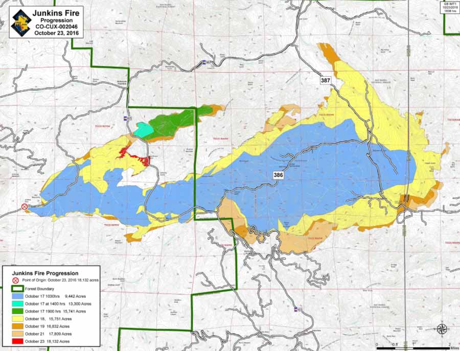
Progression map of the Junkins Fire. The large blue area burned 9,442 acres on the first day, October 17. Click HERE to see a higher resolution version.

Firefighters are working on containing the northern flank, progressing east from Highway 165. Indirect dozer and hand line will be constructed along the Hardscrabble Creek drainage in preparation for planned firing operations. The northeast and eastern divisions remain in monitor and patrol status with engines continuing to secure areas around structures.

Along the southern portion of the fire, crews continue burning operations where needed, constructing direct line where possible. Multiple water sources have been established to assist as mop up operations continue.

bobcat Junkins Fire
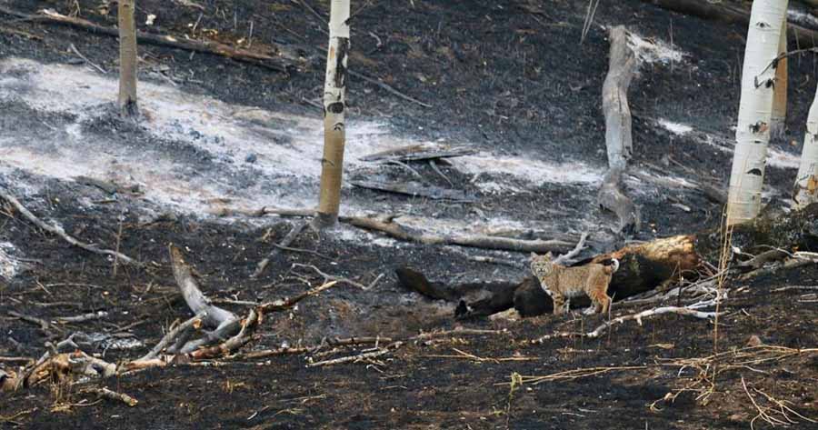
A bobcat on the Junkins Fire near Highway October 25, 2016. USFS photo by Daryl Bressan.

Articles on Wildfire Today tagged “Junkins Fire”.

Firefighters continue to battle the Junkins Fire west of Pueblo, Colorado

Above: Map of the Junkins Fire, October 21, 2016. The black line is completed fireline, while the red line is uncontained. Produced by the incident management team.

(UPDATED at 10:48 a.m. MDT October 22, 2016)

The number of structures burned in the Junkins Fire west of Pueblo, Colorado has been updated. Officials are now saying 8 homes and 19 outbuildings burned, but only one of the homes was a primary residence. The incident management team is still calling the fire 17,809 acres.

The last of the evacuation orders for the portion of the fire in Pueblo County have been lifted. Evacuations are still in effect in some areas of Custer County.

The number of personnel and equipment assigned to the fire has significantly increased, to 722.

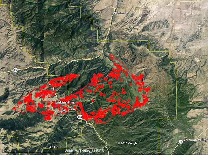
The map below shows heat detected by an aircraft at 12:18 a.m. MDT October 22, 2016.

map junkins fire
Map showing heat detected by an aircraft over the Junkins Fire at 12:18 a.m. MDT October 22, 2016.

Continue reading “Firefighters continue to battle the Junkins Fire west of Pueblo, Colorado”