Colorado fire chiefs’ recommendations for improving wildfire response

Each year since 2013 the Colorado Legislature has created interim Wildfire Matters Review Committees, with the apparent primary purpose of proposing bills relating to wildfire. And every year the Colorado State Fire Chiefs Association (CSFC) submits to the committee a broad range of recommendations for improving the state’s ability to mitigate and respond to wildfires.

This year is no exception. On August 15, CSFC Executive Director Garry Briese testified before the 2016 committee, providing the association’s view of the progress that has been made, the work underway, and the work that remains to be done on seven priorities that the CSFC first identified in 2013.

The written version of the testimony is an interesting look at how the association’s recommendations have evolved since 2013. For each of the seven priorities an update was added every year showing the history of the progress made, or not made, in each category.

Their seven recommendations, with the three highest priorities at the top, are:

  1. Ensure the stability and reliability of the current Colorado statewide emergency radio system;
  2. Continue to invest in the development, expansion and implementation of the State resource mobilization plan;
  3. Expand the current local, regional and state command, control, and coordination capabilities;
  4. Provide sufficient funding to the Division of Fire Prevention and Control (DFPC) to fulfill its stated missions;
  5. State aviation resources are an essential and integral part of the initial attack on WUI fires; 
  6. Develop measurable and clearly articulated performance goals for response to WUI fires to guide the response of local, mutual aid and State resources; and,
  7. Recognize that while community and individual homeowner mitigation is an essential component of a comprehensive WUI strategy, it is not an effective immediate or mid-term solution to our State’s immediate threats.

The report identifies progress in mobilization, and called as success stories the multi-mission aircraft, the Colorado Wildfire Information Management System (CO-WIMS), and the Colorado Center of Excellence for Advanced Technology Aerial Firefighting. But much remains to be done, the CSFC report said, in communications, homeowner hazard mitigation, and support for incident management teams.

You can read the entire document here.

Thanks and a tip of the hat go out to Bean.

Fire whirl on Beaver Creek Fire two months after the fire started

fire whirl beaver creek fire
Fire whirl on Division G of the Beaver Creek Fire August 15, 2016. Photo by Charles Bolt, Engine 1419.

Firefighter Charles Bolt took this impressive photo of a fire whirl on the Beaver Creek Fire. It was tweeted by the Medicine Bow-Routt National Forests and Thunder Basin National Grassland.

More information about fire whirls, fire tornados, fire devils, firenados, and fire storms.

Since the Beaver Creek Fire started on June 19, 2016 it has burned over 36,000 acres in northern Colorado and southern Wyoming. It is being managed by the Atlanta National Incident Management Organization (NIMO). The team described their strategy:

This is a full suppression fire utilizing both ground and aerial assets. Firefighters are engaging the fire out of the timber in areas which give them the highest probability for success. This suppression strategy provides for both firefighter safety and the protection of life and property.

After almost two months, the team claims 44 percent of the perimeter has been contained. They expect full containment on October 21 (the year was not specified). It sounds like they may be stretching the definition of “full suppression”. So far they have spent $20,600,000 of taxpayers’ money.

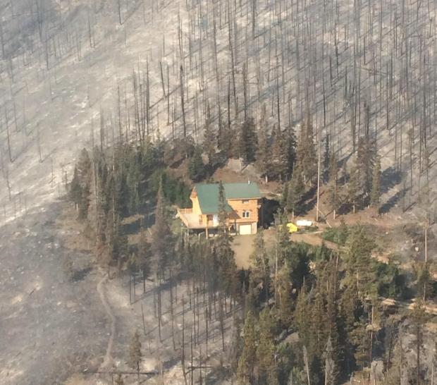
Here is another photo from the fire. Found on InciWeb, it is undated and uncredited.

Beaver Creek fire saved structure

Colorado’s Beaver Creek fire expected to burn into October

Firefighters are anticipating that it will take them until late October to contain the Beaver Creek fire, which is burning in one of the forests hardest hit by mountain pine beetle.

Tactics being used to contain the blaze have already emerged as a case study in how to suppress fire in an environment transfigured by thousands of dead trees.

Beetle-kill trees in the area thwarted firefighters’ attempts at a direct attack — downed trees made building a fireline difficult and gusts from helicopter rotors only caused more trees to fall, according to a lessons learned report published on July 27.

An indirect approach containing the fire became essential when initial attack crews felt radiant heat from flames a half a mile away:

Because of the extreme fire behavior exhibited early on in the Beaver Creek Fire, firefighters knew a direct attack would be both dangerous and ineffective…Firefighters removed fuels, wrapped buildings, laid hoses and sprinklers around the structures, and strategically burned out around buildings in advance of the fire.

The conditions in the Routt National Forest, along the Colorado-Wyoming border, also proved challenging to firefighter safety, according to a post from the incident management team on InciWeb.

The fire is burning in heavy beetle killed timber. The infested trees are subject to blowing over contributing large amounts of down timber and providing fuel for extreme fire behavior when strong winds and terrain features are in alignment, making the timbered areas unsafe for firefighters.

The fire, which started on June 19 in north-central Colorado, spread by several hundred acres during a hot, windy and humid day this week and forced firefighters to pull back to safety zones, The Denver Post reported.

As of July 29, the fire had burned 30,137 acres and is 12 percent contained.

Thanks to some northwesterly winds, Colorado residents can expect to see smoke from the Beaver Creek fire and other western wildfires this weekend, according to an update from the Colorado Department of Public Health and Environment.

Thanks and a tip of the hat go out to Allen.

Two fire crew vehicles hit by truck, 5 firefighters injured

Five members of the Mid-Plains Interagency Hand Crew received minor injuries.

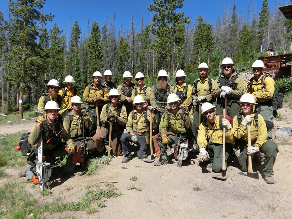
Mid-Plains Interagency Hand Crew
File photo of the Mid-Plains Interagency Hand Crew at the Beaver Creek Fire in Colorado. It was posted July 4, 2016 on the Mid-Plains Crew’s Facebook Page. The composition of the crew on July 15, the day of the vehicle accident, may have been different.

Two vehicles transporting members of the Mid-Plains Interagency Hand Crew were involved in a serious vehicle accident Thursday afternoon.

Five of the firefighters were transported to the Medical Center of the Rockies in Loveland, Colorado where they were treated and released with minor injuries.

At the time of the accident they were on Interstate 25 near Fort Collins en route to the Hayden Pass Fire south of Salida, Colorado. Traffic ahead of them came to an abrupt halt and the two vehicles were able to stop but the one in the rear had to swerve to the left to avoid the first crew vehicle.

A semi truck behind them tried to stop but careened into both firefighter vehicles, pushing the second truck into a cable median. A fuel tank on the semi truck ruptured, spilling about 50 gallons of fuel on the highway.

One of the crewmembers is a paramedic who was carrying Advanced Life Support equipment. That individual took charge of the medical response immediately at the accident scene.

The word we received is that both firefighter vehicles were totaled.

The Mid-Plains Interagency Type 2 Initial Attack Hand Crew can be assembled from a roster of fire-qualified personnel from Colorado, Nebraska, Kansas, and South Dakota. They can be from the National Park Service, U.S. Forest Service, U.S. Fish and Wildlife Service, local fire departments, state agencies, or other organizations.

Thanks and a tip of the hat go out to Mike.

Astronaut photographs Hayden Pass Fire

On Monday astronaut Jerry Williams posted these photos on Twitter from the International Space Station showing the Hayden Pass Fire 17 air miles southeast of Salida, Colorado

Perhaps with too much time on my hands I thought it would be interesting to attempt to duplicate them using Google Earth images with labeled landmarks. Click on the photos below to see larger versions.

Below, the first and third images are Mr. William’s, while the second and fourth are from Google Earth. The photos are looking east.

Jeff Williams Hayden Pass Fire
The smaller smoke in the distance may be the Hairy Fire on Ft. Carson south of Colorado Springs.

Hayden Pass fire

Jeff Williams Hayden Pass Fire

Hayden Pass Fire
The red fire perimeter was the location of the fire at 11 p.m. MDT on July 12. The white line is from 10 p.m. on July 11. Mr. Williams posted his photos on July 11.

Ours main article about the fire is HERE.